Ascent Log
- Ascent class — high-altitude and technical.
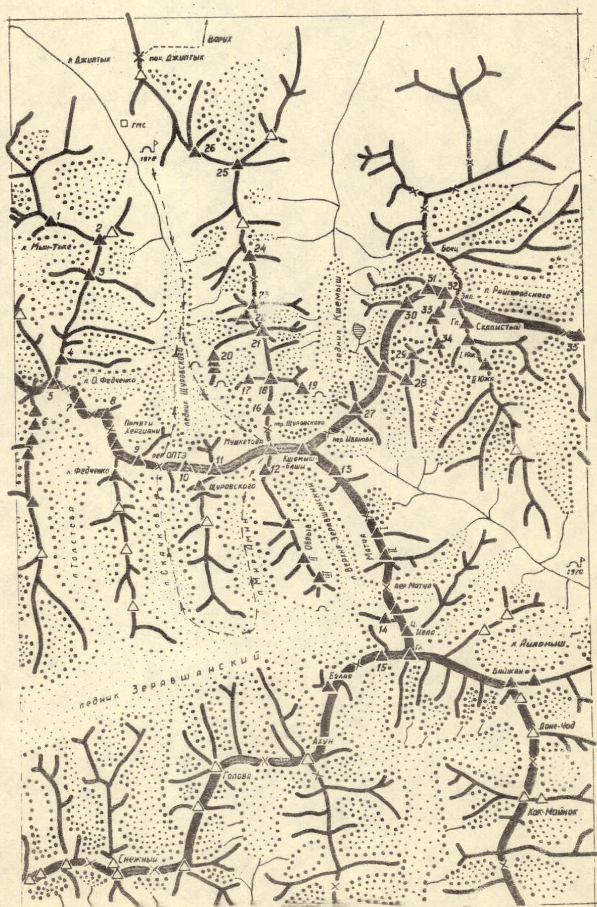
- Ascent area — Matcha node, Turkestan Ridge.
- Summit — peak Mushketova, height — 5300 m, ascent route via the center of the northwest wall.
- Proposed difficulty category — 5B.
- Route characteristics: a) height difference — 1900 m; b) length of sections with 5–6 difficulty category — 930 m; c) average steepness (sections 1–32) — 73°, (sections 32–46) — 50°.
- Number of pitons hammered for protection: rock — 192; ice — 17; bolt — 0.
- Number of travel hours — 54 (including descent), ascent — 48 h 30 min.
- Number of bivouacs and their characteristics — 4 bivouacs on the route, including two sitting bivouacs.
- Surname, name, patronymic of the leader, participants, and their qualification.
| № | Full Name | Qualification | Role |
|---|---|---|---|
| 1 | Adov Vladimir Timofeevich | CMS | Leader |
| 2 | Berezova Elizaveta Viktorovna | MS | Participant |
| 3 | Popov Vladimir Petrovich | CMS | Participant |
| 4 | Nikolaev Vladimir Nikolaevich | 1st sports category | Participant |
- Team coach: Bozhenov Nikolai Nikandrovich.
- The team started the route on July 20, 1978, and returned to "Ozerny" base camp on July 27, 1978.
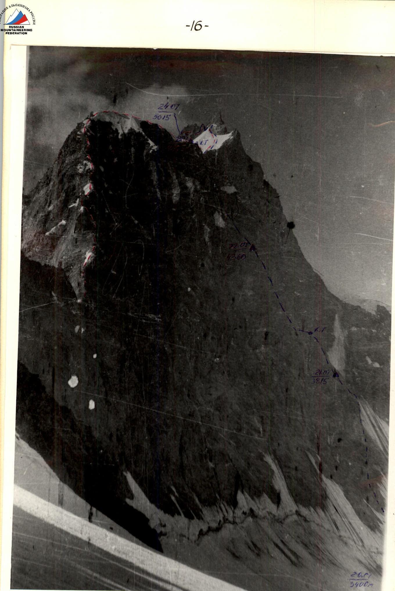
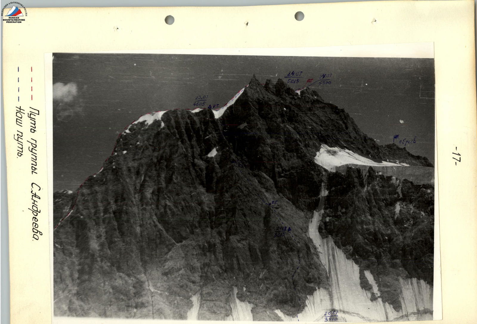
— S. Andreev's group path.
--- Our path.
Organizational and Tactical Ascent Plan
A reconnaissance sortie to the ascent area was conducted from July 18 to 19 to familiarize ourselves with the state of the northwest wall, establish a storm camp, observe rockfall regimes, and deliver food and equipment to the storm camp.
On July 18, a group consisting of Adov V.T., Berezova E.V., and Popov V.P. left "Ozerny" camp, located on the lateral moraine (left orographically) of Shchurovsky Glacier, to choose a route variant. They ascended to the glacial cirque, where the route begins, via the left part (orographically) of Shchurovsky Glacier in 3.5 hours and established a storm camp on a small central moraine, opposite the center of the northwest wall.
The reconnaissance sortie allowed us to choose the safest route in terms of rockfall danger, determine the location for crossing the bergschrund, and identify possible bivouac sites, as well as the rockfall regime.
The center of the wall features two rock triangles superimposed on each other, with the apex of the second (larger) triangle ending in a steep counterfort that reaches the northern ridge of peak Mushketova. The sides of the larger rock triangle are formed by narrowing downward gullies, creating giant funnels at the bottom of which powerful rockfalls concentrate.
Observations showed that the most rockfall-prone times are 11:00 and 20:00, i.e., when the wall begins to be illuminated and at sunset. The safest ascent path is through the center of the rock triangles. The left and right sides of the triangles are swept by powerful rockfalls, and individual rocks ricochet even into the center of the base of the lower rock triangle, so this part of the route should be traversed during the safest time, i.e., before 11:00.
The route can be divided into three parts:
- the first part is a rock triangle, the apex of which is connected to the second (larger) rock triangle by a small ridge (possible bivouac site);
- the second part is the second rock triangle, ending in a counterfort;
- the third part is the ridge with three large "jendarms".
The ridge section of the route is part of the northwest ridge traversed in 1969 (5B difficulty category). The most problematic section remains the lower rock triangle, bisected by a 100-meter white belt. The lower part of the wall, including the white belt, must be traversed within one day, as there are no visible bivouac sites, so it was decided to conduct preliminary route processing to allow the group to pass the white belt within a day, after which the wall becomes less steep. Additionally, this will enable the group to quickly traverse the most rockfall-prone section of the route the next day.
The route within the northwest wall is well observed from bivouacs on the opposite wall of the lateral moraine of Shchurovsky Glacier. It was decided to leave an observation group there.
To ensure the ascent, a group of four had the following equipment:
- main ropes 40 m × 3 (considering the need to process individual sections and traverse complex areas using double ropes);
- auxiliary rope 15 m × 1;
- Pamirka tent — 1;
- rock pitons — 35 pcs.;
- ice screws (corkscrew type) — 5 pcs.;
- ice screws (VTsSPS type) — 3 pcs.;
- carabiners — 28 pcs.;
- rock hammers — 2 pcs.;
- ice axes — 2 pcs.;
- crampons — 1 pair;
- block for pulling rucksacks — 1 pc.;
- "Tulip" radio station — 1 pc.;
- ladders — 2 pcs.;
- jammers — 3 pcs.
To reduce weight, the group took only one 4-person down sleeping bag on the route.
Food for the participants was planned for 8 days. Communication with the observation group and "Ozerny" camp was maintained using the "Tulip" radio station twice a day. The observation group visually monitored the climbers using a 12x binocular.
The team started the route in a composition of 4 people. The rope teams were formed as follows:
- Adov V.T. — Berezova E.V.
- Popov V.P. — Nikolaev V.N.
Table of Main Ascent Characteristics
Ascent route: Center of the northwest wall of peak Mushketova.
Height difference from Shchurovsky Glacier — 1900 m, including:
- Most complex rock sections (steepness > 75°) — 150 m;
- Ice sections (steepness ≥ 60°) — 160 m.
Average route steepness:
- Sections 1–32 — 73°;
- Sections 32–46 — 50°.
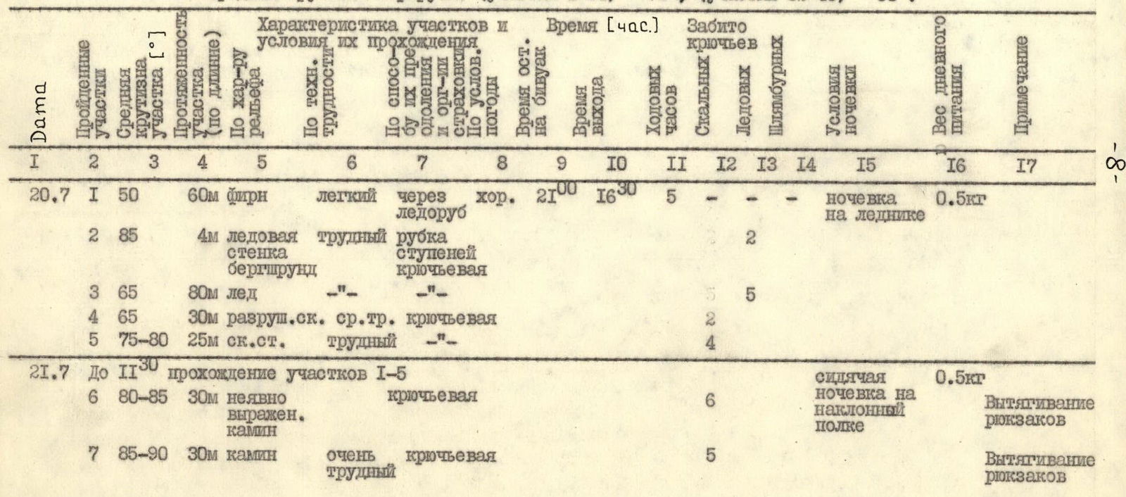
| Date | № | Steepness (°) | Length (m) | Section Characteristics | Movement Method | Bivouac Quality / Illumination | Departure Time | Travel Hours | Rock Pitons | Ice Pitons | Bolt Pitons | Total Pitons | Weight (kg) | Note |
|---|---|---|---|---|---|---|---|---|---|---|---|---|---|---|
| 20.07 | 1 | 50 | 60 firn | easy | via ice axe | good | 21:00 | 5 | - | - | - | - | 0.5 | bivouac on glacier |
| 2 | 85 | 4 ice wall | difficult | step cutting | piton | 2 | - | - | - | - | ||||
| 3 | 65 | 80 ice | -"- | -"- | 5 | - | - | - | - | |||||
| 4 | 65 | 30 destroyed rock | medium difficulty | piton | 5 | - | - | - | - | |||||
| 5 | 75–80 | 25 rock wall | difficult | -"- | 2 | - | - | - | - | |||||
| 21.07 | 6 | 80–85 | 30 vaguely expressed chimney | piton | 6 | - | - | - | - | 0.5 | sitting bivouac on inclined shelf, rucksack pulling | |||
| 7 | 85–90 | 30 chimney | very difficult | piton | 5 | - | - | - | - | rucksack pulling |
Continuation of the Table
| Date | № | Steepness (°) | Length (m) | Section Characteristics | Movement Method (Protection Organization) | Bivouac Quality / Illumination | Departure Time | Travel Hours | Rock Pitons | Ice Pitons | Bolt Pitons | Total Pitons | Weight (kg) | Note |
|---|---|---|---|---|---|---|---|---|---|---|---|---|---|---|
| 8 | 60 | 40 inclined rock slabs | medium difficulty | piton | 2 | - | - | - | - | |||||
| 9 | 70–75 | 70 inclined gap in rock wall | difficult | piton | 8 | - | - | - | - | |||||
| 10 | 85–90 | 25 chimney | difficult | piton | 4 | - | - | - | - | rucksack pulling | ||||
| 11 | 85–90 | 35 inner corner with chimney | very difficult | piton, ladders | 6 | - | - | - | - | rucksack pulling | ||||
| 12 | 60 | 40 destroyed rock slabs | medium difficulty | piton | 2 | - | - | - | - | |||||
| 22.07 | 13 | 60 | 80 rock slabs | medium difficulty | piton | good | 20–30 | 6 | - | - | - | - | 0.5 | semi-reclining bivouac on inclined shelf |
| 14 | 60 | 80 destroyed rock slabs | medium difficulty | piton | 7 | - | - | - | - | |||||
| 15 | 35 | 60 ridge top of rock triangle | - | - | - | - | - | |||||||
| 16 | 65–70 | 70 rock slabs | difficult | piton | 9 | - | - | - | - | |||||
| 17 | 75–80 | 25 inner corner | difficult | piton | 4 | - | - | - | - | |||||
| 18 | 65–70 | 35 rock slabs | medium difficulty | piton | 3 | - | - | - | - | |||||
| 19 | 75–80 | 20 rock wall | difficult | piton | 4 | - | - | - | - | |||||
| 20 | 70 | 30 smooth rock slabs | difficult | piton | 3 | - | - | - | - | |||||
| 21 | 65–70 | 65 rock slabs | medium difficulty | piton | 6 | - | - | - | - | |||||
| 22 | 75 | 20 inner corner | difficult | piton | 4 | - | - | - | - | |||||
| 23 | 70–75 | 35 rock counterfort | medium difficulty | piton | 3 | - | - | - | - | |||||
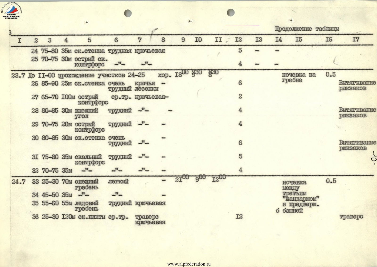
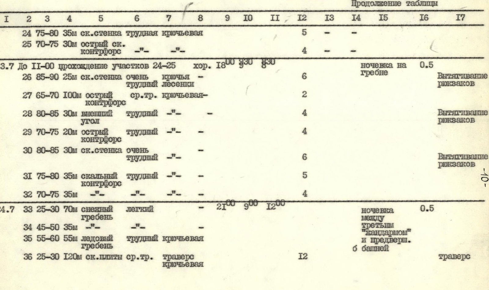
| 24 | 75–80 | 35 rock wall | difficult | piton | 5 | - | - | - | - | |||||
| 25 | 70–75 | 30 sharp rock counterfort | -"- | -"- | 4 | - | - | - | - | |||||
| 23.07 | 26 | 85–90 | 25 rock wall | very difficult | piton, ladders | good | 18:00 | 6 | - | - | - | - | 0.5 | bivouac on ridge, rucksack pulling |
| 27 | 65–70 | 100 sharp counterfort | medium difficulty | piton | 2 | - | - | - | - | |||||
| 28 | 80–85 | 30 outer corner | difficult | -"- | 4 | - | - | - | - | rucksack pulling | ||||
| 29 | 70–75 | 20 sharp counterfort | difficult | -"- | 4 | - | - | - | - | |||||
| 30 | 80–85 | 30 rock wall | very difficult | -"- | 6 | - | - | - | - | rucksack pulling | ||||
| 31 | 75–80 | 35 rock counterfort | difficult | -"- | 5 | - | - | - | - | |||||
| 32 | 70–75 | 35 | -"- | -"- | 4 | - | - | - | - | |||||
| 24.07 | 33 | 25–30 | 70 snow ridge | easy | - | - | - | - | - | 0.5 | bivouac between third "jendarme" and pre-summit 6th tower | |||
| 34 | 45–50 | 35 | -"- | -"- | - | - | - | - | - | |||||
| 35 | 55–60 | 55 ice ridge | difficult | piton | 12 | - | - | - | - | |||||
| 36 | 25–30 | 120 rock slabs | medium difficulty | traverse, piton | 16 | - | - | - | - | traverse | ||||
| 37 | 75–80 | 335 rock wall | difficult | piton | 4 | - | - | - | - | ascent to pass between 1st and 2nd "jendarme", rappel descent | ||||
| 38 | 75–80 | 25 | -"- | -"- | 3 | - | - | - | - | |||||
| 39 | 25 | - | - | - | - | - | ||||||||
| 40 | 25–30 | 200 ice-covered rock slabs | medium difficulty | traverse, piton | 16 | - | - | - | - | |||||
| 41 | 55–60 | 60 ice gully | difficult | piton | 4 | 2 | - | - | - | |||||
| 42 | 75–80 | 35 rock wall | -"- | -"- | 4 | - | - | - | - | ascent to saddle before summit tower | ||||
| 25.07 | 43 | 65–70 | 80 rock slabs | medium difficulty | piton | good | 22:00 | 4 | - | - | - | - | 0.5 | bivouac on Zeravshan Glacier |
| 44 | 65–70 | 40 ice | difficult | -"- | 2 | 1 | - | - | - | |||||
| 45 | 65–70 | 80 destroyed rocks covered with ice and snow | medium difficulty | 6 | - | - | - | - | ||||||
| 46 | 45–50 | 120 loose snow | easy | ice axe | - | - | - | - | - |
The team reached the summit of peak Mushketova at 12:00. The descent was made to the saddle via the ascent route, then via a gully to Mir-Amin Glacier and down to Zeravshan Glacier.
Total:
- travel hours including descent — 54
- rock pitons hammered — 192
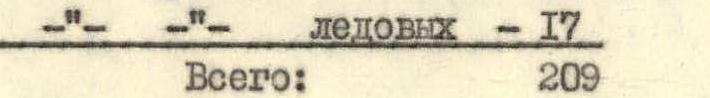
- ice pitons — 17
- Total: 209
Ascent Log
July 20. At 16:30, the rope team Adov V.T. — Berezova E.V. departed from the storm camp to process the route. Weather is excellent.
Remaining on bivouac:
- Popov V.P.
- Nikolaev V.N.
- Two observers: Kobozev V.D., Medvedskikh A.
Objectives of the sortie:
- Find the optimal passage through the bergschrund.
- Process the ice slope.
- Hang at least one rope in the lower part of the rock triangle.
Equipment taken for processing:
- One 40 m rope.
- One 80 m rope.
Decision on the bergschrund: pass at the point of detachment of the ice slab from the upper part of the ice slope, where the bergschrund step is smallest — 4 m. Difficult ice work with step cutting.
The 80 m rope was just sufficient to reach the base of the rock triangle.
At the moment Adov V.T. reached the rocks, a powerful rockfall descended from the right (by direction) gully. Individual rocks ricocheted into the area where Berezova E.V. was standing on belay, but the bergschrund reliably protected her. The first climber was already in a safe location.
Via destroyed rocks of medium difficulty, slightly traversing to the right, we hang another rope, leave hammers, pitons, and quickly descend, where a hot dinner awaits.
July 21. At 9:00, the group departed for the route in full composition. We pass the 80 m rope and throw it down to the observers. At 11:30, the first rope team reaches the end of the last rope hung yesterday. Straight up — a vaguely expressed chimney, which becomes more pronounced at the top.
Adov V.T. changes into galoshes and passes the first rope (difficult climbing, occasional swinging, but good holds), organizes belay on a ledge where two people can barely fit. The next rope is no less difficult but leads to a fairly spacious platform where we organize a transit (two ropes) rucksack pull. The block is very helpful!
Along inclined rock slabs with debris-covered ledges, we approach the base of the white rock belt. Very steep, overhanging monolithic rocks, but a narrow crack goes up to the right, which we decide to follow.
- Two ropes of complex climbing through the crack to the base of the chimney.
- The chimney is formed by a rock wall and detached rock blocks, ending about 30–35 m up.
- Further, two walls form an inner corner of 90°.
- Between the walls — a narrow gap, which can be called a chimney with some stretch, with a length of 35–40 m.
Adov V.T., using the full arsenal of chimney technique, reaches the end of the rock blocks, where there is a fairly good platform for organizing belay.
Next is an inner corner, perhaps the most complex section of the entire route:
- Steepness is over 90° in places.
- Monolithic rocks.
- Lack of holds.
- Practically no places for hammering pitons.
All this complicates its passage. The corner leads to overhanging rocks, so it's necessary to move right onto a smooth wall 3–4 m high, ending in an inclined ledge. Ladders were used when passing the wall.
Further — another transit rucksack pull, which after 4 pulls started to look worn out.
Passing the chimney and inner corner took about 5 h 30 min.
After the chimney, along inclined slabs — one rope of medium difficulty climbing and a relatively comfortable bivouac site — a small "sidewalk" where four people can fit. The last person reaches the bivouac site already at 22:00.
July 22. We departed from the bivouac at 9:30. Weather is good. The route is visible up to the exit onto the ridge.
Up to the top of the first rock triangle, the route consists of inclined slabs with individual small walls. Nikolaev V.N. leads. Today is his turn to work first. Slabs are not very steep — 60–65°, but there are few holds; the first climber wears galoshes and relies mainly on friction. Protection is piton with rope fixing.
To the top of the rock triangle from the bivouac:
- 4 ropes
- 3.5 hours of work
As expected, there's a convenient spot for bivouac on the "ridge" of the rock triangle. We build a cairn.
Next — the wall of the second rock triangle: wide at the bottom and turning into a counterfort at the top. We ascend via steep slabs under a vaguely expressed inner corner, bypassing overhanging rocks on the left. Along the inner corner, 25 m of complex climbing leads us to rock slabs again. There are few holds and places for piton placement. The first climber wears galoshes, relying mainly on friction.
Slabs turn into a 20 m rock wall. Climbing is complex. We gratefully recall the inventors of jammers — they allow passing very steep sections on fixed ropes without pulling rucksacks.
After the wall — another 90 m along rock slabs of medium difficulty. We approach the last obstacle before reaching the counterfort — an inner corner. One rope of complex climbing, but again, we manage without pulling rucksacks.
The first rope of medium difficulty on the counterfort leads to a small platform where we organize a bivouac. Berezova E.V. and Popov V.P. work on bivouac arrangement, while Nikolaev V.N. and Adov V.T. process the route.
Immediately beyond the bivouac site — a 30 m rock wall, steep but with good holds. After the wall, we pass another rope along a sharp counterfort under an overhanging rock bastion and descend to bivouac. The bivouac turns out to be semi-reclining again.
July 23. From 9:30 to 11:00, we pass the previously fixed ropes and reach under the rock bastion. Nikolaev V.N. leads. He attempts to bypass the bastion on the left but fails. Then he goes straight. Climbing is very complex. At the top — an overhanging rock cornice. We pass the cornice using ladders. At this section, we again organize rucksack pulling.
Further:
- along a sharp, steep counterfort under a rock ascent in the form of an outer corner;
- rocks are steep, monolithic, with few holds;
- again, rucksack pulling;
- then along the counterfort (20 m) to a large rock bastion leading to the ridge.
The lower part of the bastion (30 m) is the steepest, with very complex climbing and rucksack pulling. Further, the wall becomes less steep. After 70 m of complex climbing, we reach the ridge. On the top of the rock bastion, we build another cairn. In the ice hollow — an excellent bivouac site (compared to the previous ones). Fatigue is accumulating, the altitude is taking its toll, lack of water on the wall, and rucksack pulling are felt. It's 18:00, but we decide to stop for bivouac.
July 24. At 9:00, we reluctantly leave the bivouac. Along a snow ridge (70 m), transitioning to an ice ridge in the upper part (crampons, step cutting — 35 m), we reach an ice hollow under the first "jendarme", which we bypass on the left along inclined, icy slabs and debris-covered ledges.
The ascent to the saddle between the first and second "jendarme" is complex. Further along the ridge, 25 m — ascent to an intermediate "jendarme" with a sporty descent under the large second "jendarme". To the right, we see rappel anchors. Apparently, one of the previous groups bypassed the second "jendarme" on the right. We decide to bypass it on the left.
Along steep, icy rocks and debris-covered ledges, we traverse (200 m) into an ice gully leading under the saddle between the second large "jendarme" and the summit tower. Along the boundary between ice and rocks (60 m of difficult climbing) — under a rock wall. 35 m along steep rocks, and at 20:30, we reach the saddle under the summit tower, where we organize a bivouac.
July 25. We departed from the bivouac at 8:00 without rucksacks. From the saddle between the second "jendarme" and the summit tower, the ascent is initially along icy rock slabs (40 m), then a traverse to the left along ice with a transition to ridge rocks (30 m). Another 120 m of difficult climbing along icy rocks to the last rock massif, from where 60 m along blue, steep snow leads us to the summit. The summit is snow-covered. To the right, slightly below, rock outcrops are visible.
The descent to the saddle is via the ascent route. At 14:00, we begin descending along a snow-ice gully to Mir-Amin Glacier and further to Zeravshan Glacier, where we have our fifth bivouac.
July 26. We ascended via Skachkov Glacier to the OPTAE pass and descended to Shchurovsky Glacier into "Ozerny" camp.