21 TC-6
USSR Alpine Championship 1973
Kshmysch via North Face
Report on the Ascent by the Leningrad City Committee for Physical Culture and Sports
Brief Geographical Description and Sporting Characteristics of the Route
Kshmysch peak, 5300 m, is one of the highest peaks in the Matcha mountain cluster. It is located almost in the center of the Turkestan ridge between the peaks "25 лет ПНР" and Mushketov, and naturally closes the Kshmysch river gorge. The simplest path to the summit is via the Ivanov pass along the northeast ridge, category 4B.
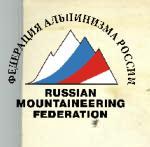
To the north, the massif drops off in an almost sheer wall with a height difference of 1800 m. The wall has significant glaciation. The rocks are heavily weathered. The possibility of traversing this wall, the main alpinist object in the area, is problematic due to both the high technical difficulty and the complexity of choosing a safe route (the wall is exposed to rockfall). In 1972, a team from Novosibirsk attempted to traverse the wall but managed to pass only a small part of the lower bastion before being forced to descend (see photo 1).
The route along the wall includes both purely rock sections of great steepness (about 90°) and length, reminiscent of the Uzba walls and routes in the Fann Mountains, as well as ice sections (rock with ice, icy slabs, steep ice slopes at the beginning of the route) - this makes the route similar to those found in the Bezengi walls (K Koshtan-Tau from the northwest, etc.). The route is significantly more demanding than many well-known walls due to the heavily weathered rocks, posing complex tactical challenges for the group related to organizing movement and ensuring safety. Thus, the route is closer to combined climbs, although rock work predominates. In terms of overall steepness, it is not inferior to purely rock routes: the overall steepness is about 80°, and the steepness of the most difficult sections is more than 80°.
Brief Description of Climbing Conditions in the Matcha Mountain Cluster
The Matcha mountain cluster differs from other Pamir-Alai regions with less stable weather. Rain and snow in the second half of the day and two- to three-day bad weather recurring every 5-6 days are not uncommon here. This makes the area similar to the Bezengi valley. There are significant temperature fluctuations between day and night. In the high-altitude zone, temperatures drop below 0 °C (in August down to –10…–15 °C) with sunset, making overnight stays in hammocks without tents problematic towards the end of summer.
The mountain relief is characterized by significant glaciation and snow cover, but there are almost no snowy slopes; under a thin layer of snow, there is usually ice, and the snow typically "does not hold" well: steps do not compact well, and snow collapses to the ice base.
The rocks in the area are heavily weathered, and rockfall is a characteristic phenomenon. Any route has an abundance of "live rocks."
Team Preparation and Training Cycle
a) Team Preparation
The team has existed for many years and has worked in various regions of the Caucasus and Pamir. It is composed of the best rock climbers from the "Trud" Sports Society and Leningrad. The team members have extensive experience with Bezengi ascents.
b) Training Cycle in the Mountains
The team arrived in the Kshmysch gorge together with the LIG alpine group on July 22, 1973. On July 25, we first saw the Kshmysch wall (during a special reconnaissance sortie). The wall looked very imposing. However, the snow and ice under the wall were blackened by rocks. Careful observation was required to choose the route.
By July 27, 1973, the base camp was set up, and on July 28, the team embarked on a training ascent. A peak in the Kshmysch area was chosen to simultaneously observe the wall. On July 29, we ascended the Yar-Tash peak, category 3B. Observing the wall did not bring us the desired reassurance. The "war" did not cease even at night. However, during this sortie, we managed to localize the active rockfall areas. The conclusion was not very reassuring:
- The left and rightmost parts of the wall are less exposed to rockfall than the rest of the wall;
- careful additional observation is required to precisely choose the route.
Meanwhile, it was necessary to focus on the team's athletic form.
On August 1, 1973, the team set out on a first ascent of the north counterfort of the Vertical peak (5130 m). The goal was to practice teamwork on complex terrain, improve athletic form, and further familiarize ourselves with the specifics of challenging ascents in the area. The ascent proved to be quite difficult (category 5B).
On August 7, 1973, we returned to camp.
On August 10, 1973, the duo Romanenko - Borzov ascended the Kirokhan peak, category 2A, with the additional goal of inspecting the north-east wall of peak S. Andreev.
To enhance the athletic form of participants Miasnikov and Romanenko, another challenging ascent was necessary. Moreover, the main task - choosing a route up the north face of Kshmysch - remained unsolved.
- The duo Solonnikov V. - Antonovsky D. headed under the wall for prolonged observation of the route;
- the trio Miasnikov V., Borzov Yu., Romanenko N. ascended the northeast ridge of peak S. Andreev, category 5B.
As a result of the observation, a route variant was chosen, and the ascent tactics were developed.
On August 14, 1973, Grachev A. and Vasiliev B., who had returned from Italy, arrived. Finally, everyone was together. After resting, on August 16, 1973, the first trio - Antonovsky D., Vasiliev B., Grachev A. - headed to the upper camp. The ascent began.
Observation of the Route and Ascent Tactics
Three cycles of observation were conducted:
- July 25, 1973 - initial observation. The fact of objective danger was established, and a general assessment of the route was made.
- July 28, 1973 - July 29, 1973 - localization of dangerous zones and a rough assessment of the feasibility of various route options.
- August 10, 1973 - August 14, 1973 - refinement of the ascent route.
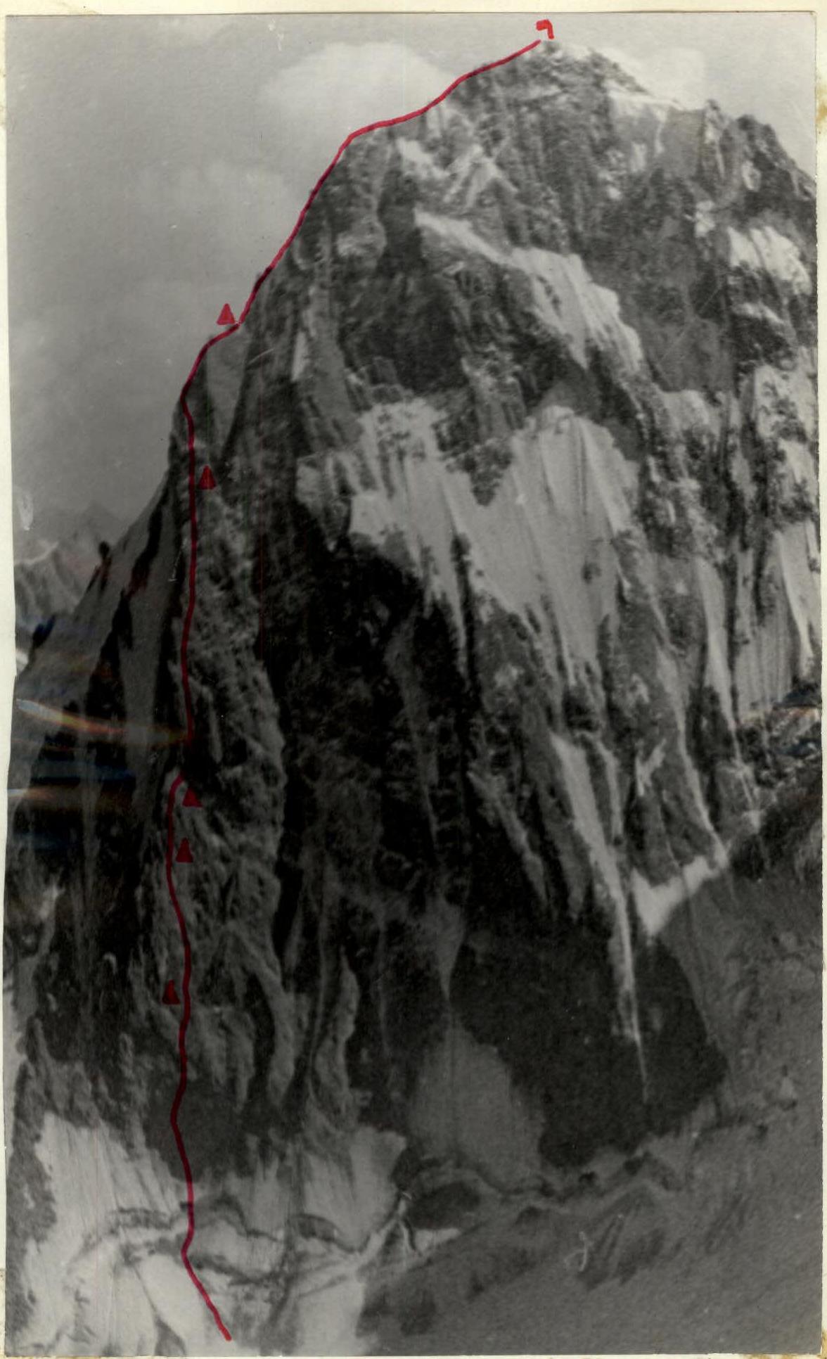
As a result of the observation, a diagram was compiled (photo 4).
Conclusions:
- The central and left parts of the wall are subject to constant rockfall at any time of day.
- The right part of the wall is affected by falling ice from above.
- The most active rockfall occurs from 11:00 and in the evening.
- After 11:00, the lower part of the wall (ice sections) is exposed to falling single rocks.
- The most calm period is during stable weather, in the second half of August (significant cooling), and during night and morning hours until 10:00-11:00.
- In the left and possibly right parts of the central wall, movement is practically safe during morning hours (until 11:00-12:00!).
- The "activity" of the wall is likely due to the weathered state of the rocks, and increased rockfall danger should be expected along the entire route due to "live rocks."
Based on the observation results, a route along the left part of the wall was chosen (photo 4). The starting point of the route required additional clarification, with two options considered:
- either through a rock protruding from the upper edge of the bergschrund;
- or to the right of it.
The Novosibirsk team's starting variant (via the "comma") was dismissed as objectively dangerous that year (and, indeed, during the ascent, repeated rockfalls were noted along this path).
The tactics were based on the following principles:
- The lower section must be traversed quickly (before 11:00), so a day of preliminary processing is necessary.
- NIGHT Stays (especially the first one) should be made under overhanging roofs (protected from rocks).
- During each night's organization, further processing of the route should be carried out to accelerate the group's overall movement.
- Movement should avoid going straight up, ensuring participants are not positioned directly above one another.
- Rucksacks should be maximally lightened since, in many places, due to rockfall danger, they will have to be carried.
- Early departures should be made on the first day and processing day (by late August, dawn is around 6:00).
Team Composition as per Application and Assault Group
The Leningrad City Committee for Physical Culture and Sports team was entered into the USSR Alpine Championship with the following composition:
- Solonnikov Viktor Aleksandrovich - Master of Sports, captain and coach
- Vasiliev Boris Petrovich - Master of Sports, deputy captain
- Grachev Andrei Borisovich - Master of Sports
- Antonovsky Dmitry Igorevich - Master of Sports
- Romanenko Nikolai Pavlovich - Master of Sports
- Solonnikov Vladimir Aleksandrovich - Master of Sports
- Borzov Yuri Vyacheslavovich - Candidate for Master of Sports
- Miasnikov Vladimir Lvovich - Candidate for Master of Sports
- Manoylov Yuri Semenovich - Candidate for Master of Sports
For the ascent, six of the strongest athletes were selected. We managed to form a homogeneous assault group in terms of strength and preparation, and this year the team entering the route was stronger than in 1972.
Assault Group Composition:
- Solonnikov Viktor Aleksandrovich - Master of Sports, captain
- Antonovsky Dmitry Igorevich - Master of Sports
- Vasiliev Boris Petrovich - Master of Sports
- Grachev Andrei Borisovich - Master of Sports
- Romanenko Nikolai Pavlovich - Master of Sports
- Borzov Yuri Vyacheslavovich - Candidate for Master of Sports
The observation group was led by team member, Candidate for Master of Sports, Miasnikov Vladimir Lvovich.
Ascent Plan
The ascent was planned as follows: one day for processing and six days for the ascent. The planned overnight stays are indicated on (photo 4) (First overnight stay under an overhang). The lower bastion was to be traversed in two days, followed by a day of processing the second bastion. Then, traversing the second and processing the third bastion (fourth day), followed by traversing the third bastion, and on the sixth day, reaching the summit (see route sheet). This ascent plan was executed with great precision (see photo 4).
Route Progression
First Day. August 16, 1973
The trio Vasiliev, Grachev, Antonovsky departed from the base camp and arrived at the camp under the route on the moraine ("Sunny Nights") by evening. The group brought the necessary equipment and supplies for the ascent.
Second Day. August 17, 1973
Vasiliev, Grachev, Antonovsky conducted additional observation of the lower part of the route to finalize and choose one of the two previously considered variants for traversing the ice ledge (upper edge of the bergschrund) and the ice slope.
The left variant - through a rock protruding from the ice ledge - was deemed safer, although it is somewhat more challenging than the right-hand option:
- more нависающая часть (overhanging part?);
- the ice slope is longer and steeper;
- however, the lower part of the bergschrund and the lower section of the ice slope are protected by the ice ledge.
By evening, Solonnikov V. arrived. It was decided that the processing group would consist of Vasiliev B., Grachev A., and Antonovsky D. They needed to depart early, attempt to hang ropes on the ice, and begin work on the rocks. Starting from 11:00-12:00, the lower part of the route (ice exit) could be exposed to single falling rocks, so special attention should be paid to organizing the group's return.
Third Day. August 18, 1973, Processing
At 6:00, the trio, carrying all available ropes and "hardware," exited through the labyrinth of crevasses along the pre-marked path, reached the glacier, and approached the route. A small ascent over ice covered with rocks, and the start of the route - a steep ice climb leading to the lower part of the bergschrund - was reached. The ice was dirty, with sand and small rocks frozen to it, and a steepness of about 60°. Movement was on front points with hook protection (section R0-R1). There were two pairs of crampons. The third participant, Antonovsky, moved on a Jumar, with vibram soles sliding, making progress difficult.
The group gathered at the lower edge of the bergschrund.
 The wall was quiet so far, but here the team was relatively safe, which was comforting.
Upward, a slightly overhanging ice slope - the upper edge of the bergschrund - stretched. To the left of the ice, a black, overhanging rock protruded. The path passed over ice beside the rock and then through a crack upward. Rock pitons and ladders were used (section 1-2, photo 7). Reaching the top of the rock took until 9:30. From below, it was expected to be faster.
Next was an overhanging ice section (section 2-3, photos 8, 9). Initially, a traverse, and then, on ladders and ice screws, an exit through the overhang onto an ice slope.
Further, the duo Vasiliev - Grachev worked. Antonovsky returned to camp via the hung ropes. The ice slope required step-cutting due to very hard and dirty ice; crampons did not hold well (section 3-4).
Finally, the duo reached the rocks. 12:00. The wall "started working." Rocks flew down the couloirs, but all were to the side. Grachev put on galoshes. There was a need to hurry.
After 15 m, the path was blocked by a cornice. Grachev moved left via a pendulum and then further along slabs with micro-footholds (section 5-6). Eventually, they managed to exit into an internal corner. From here, the path upward was a steep internal corner with small cornices. The rocks were still quite monolithic.
The ropes ran out. It was time to begin descent. Hung:
- 4 ropes of 45 m;
- one of 40 m.
Total - 220 m. Hammered in:
- 12 ice screws;
- 17 rock pitons.
Time - 16:00. Rappel was six-point. Descent took 1 hour. At 17:00, everyone was back in camp.
Tomorrow, it was necessary to:
- depart no later than 6:00;
- by 10:00-11:00, everyone had to be on the rocks.
Staying in the lower part of the wall later was dangerous.
At 18:00, team members from the Ivanovo-Frankovsk collection point reported that an accident had occurred in the Kavunenko group while descending from the Ivanov pass. We had no ropes and only one pair of crampons left. We set out.
The rescue of the injured party continued until 21:00.
Around 22:00, we returned to camp. Here, we were met by:
- Romanenko;
- Borzov;
- Miasnikov, who had arrived from the base camp with additional supplies and fuel.
Fourth Day. August 19, 1973 (First Day of Ascent)
At 6:00, we departed. The mood was combative. By 10:00, the last person passed the ropes hung on the ice. One rope was dropped to the observers. Crampons were worn by the first and last.
Rucksacks were hauled twice over 80 m. The wall "came to life." Sometimes rocks flew down the ice, but we were already higher, and it didn't threaten us. Processing the hung ropes on the rocks took another 2 hours. Rucksacks had to be continuously hauled.
The path upward went along a steep and narrow internal corner, transitioning into a crack (section R7-R8, photos 11, 12). Twice, small cornices were encountered, which were traversed head-on using ladders. It was cold. The group was moving quickly so far.
- A sheer wall with a small ledge;
- a slab that had to be traversed via a pendulum.
(Photo 14).
Further, an inclined crack led to the base of an internal corner (section R8-R9). Rucksacks were hauled onto a small ledge. Upward, a narrowing internal corner stretched (section R9-R10). It was necessary to stop on a piton twice. Then, a traverse right along an icy slab (section R10-R11). For the first person in galoshes, it was unpleasant, and even in vibrams, it wasn't pleasant. Live rocks became more frequent. Upward, a sheer wall with a small cornice and then a wide chimney with live rocks. A very difficult section (section R11-R12, photo 13). During rucksack hauling, rocks fell. Fortunately, the rocks overhung. The upper part of the route on Chapdara from the north came to mind. Apparently, the entire route was similarly weathered.
Sheer slabs (section R12–R13) and another 45 m along less steep rocks - we managed to pass with rucksacks. We were on a small ledge. 17:00.
Upward stretched a sheer and slightly overhanging wide corner. We wouldn't make it to the end of it today, and there was no safe overnight stay there? Besides, where we were, the ledge was directly under the corner, and once it was passed, it would be safe. To the right, 20 m away, under a cornice, was the planned overnight stay location. (Photo 15). There, the ledge was quite small, less than a meter wide. The duo Grachev - Romanenko set out for processing, while the rest worked on establishing the overnight stay. By 20:00, the ledge was equipped: a tent was suspended.
The processing duo returned. They advanced 60 m. The relief was very complex (Fig. 1, sections R14–R15, R15–R16, R16–R17, R17–R18, photo 16). Many huge slabs barely clung to the rock, requiring extreme caution during movement. Midway through the section, a cornice and then, apparently, a traverse of it along a slab to the right; but the slab was sheer, and on it, a thin layer of ice - that was a problem for tomorrow. For the day, 445 m were covered (including the processed section from the previous day). The tempo was good. Another 60 m were processed. 45 rock and ice pitons were hammered in. Climbing was extremely challenging, even in galoshes. On all sections that day, except R13–R14, rucksacks were hauled. The team was tired. We settled in for the night. Five people sat in the tent, and one lay outside, covered with a cloak. The overnight stay was not too comfortable but was safe - there was a cornice above. At 21:00, we had radio contact. We sent up a flare - all was well.
Fifth Day. August 20, 1973 (Second Day of Ascent)
Wake-up was at 6:00, departure at 8:00. Since it was assumed that from under the first cornice, movement would be under the second cornice and then, crossing the corner to its right part, towards a small ledge where rucksacks would be hauled, and then left upward (see Fig. 2), the lower ledge, from which rucksacks would be hauled, was a dangerous place regarding live rocks. Participants moved according to the following scheme (see Fig. 2):
- The duo processed the sections and began moving further to the ledge, while the rest remained at the overnight stay.
- The trio entered from the overnight stay and began moving under the cornice; the duo was on the ledge, and the last person was at the overnight stay.
- The first person moved further to the top of the corner; the trio gathered under the cornice.
- Two from the trio entered the ledge; the first person was at the top of the corner; the fifth was under the cornice; the sixth was at the overnight stay.
- The sixth person approached the rucksacks, and their hauling began.
- The last person reached under the cornice; the trio exited to the top of the corner.
- The fifth and sixth entered the ledge; the next cycle of rucksack hauling began.
With this movement, we managed to minimize the risk of participants being hit by live rocks on these sections, although the pace slowed slightly. The sections proved technically very challenging. When traversing the 1st cornice (section R18–R19, photo 17), it was necessary to hammer in a shovel piton. The frozen ice on the smooth slab was chipped away with a hammer. A pendulum was used. A wet, sheer slab led under the second cornice (photos 18, 19), and again a pendulum with a downward and rightward movement onto small holds covered in ice. Then, upward along the slab and along blocks frozen into the ice onto a small ledge. There were few cracks on the section; climbing was extremely challenging. Then, another traverse, but leftward under the cornices, into the corner. The corner slightly overhung. On ladders, we managed to exit onto its left wall and then upward (section R20–R21, photo 20, Fig. 1). The path was visible rightward and upward, crossing internal corners along icy slabs with a steepness of about 75°, entering a not clearly defined corner, and along it to the right part of the wall. (Photo 22). The rocks were a jumble of live rocks. Hauling rucksacks was impossible - it would inevitably trigger a rockfall; we had to climb with rucksacks (section R21–R22). The same situation persisted on the following sections. Movement along the corner, transitioning into a crack, and then along a wall with small holds. (Photo 21). Further, a very difficult section. From above, a cornice - it was traversed leftward and upward through a crack; here, live blocks overhung; through them onto a slab and then upward. Rucksacks could be hauled - rocks fell to the right (section R23–R24, Fig. 3). Another 20 m along an external corner to a small ledge. Here was the 1st control point. It was impossible to proceed further: the path went rightward along a wall and then into a wide internal corner filled with ice like a "mulda." Everything was clogged with live rocks, and rockfall was unavoidable. Time was 19:00. The duo Vasiliev - Grachev continued upward, while the rest descended along a chimney 20 m to a small ledge, where a sitting overnight stay was organized. The ledge was protected by a cornice, and rocks indicating the movement of the processing duo flew past. (Photo 24). The platform where the tent was suspended allowed four people to sit; two were perched on a ledge 2 meters to the right. The processing duo advanced about 100 m - this included exiting through an overhanging block (section R26–R27) onto a wall (section R27–R28) and into a "mulda" (section R28–R29). The rocks were covered with a thin 1-2 cm layer of snow; underneath were live rocks and ice. A very unpleasant and psychologically challenging place, but further movement was visible under the second sheer bastion. In the evening, via radio, we learned that Nezamtdinov had reached the summit. Radio communication was excellent; observers reported that they had been watching us the entire time. For the day, 180 m were covered, and another 100 m were processed. 51 pitons were hammered in. We worked for 12 hours. Everything was proceeding according to plan.
Sixth Day. August 21, 1973 (Third Day of Ascent)
Wake-up was at 6:00. Departure at 8:00. Again, the usual movement scheme was inapplicable. The processed 100 m had to be traversed one by one. Everyone remained at the overnight stay. As each 100-meter segment was completed, the participant signaled to the next that they could move. Climbing was very challenging; hauling rucksacks was impossible - they would go to the right and directly above the overnight stay. We had to climb with rucksacks. Another 20 m along slabs (section R29–R30) and then a traverse (section R30–R31) brought us under the II bastion. 14:00. The bastion stood as a sheer wall, an "étagère" of cornices (photos 26, 25). Here, an overnight stay would be established. The duo Grachev - Romanenko was to traverse the II bastion today. After a brief snack, they continued work. Simultaneously, the construction of the overnight stay began. Huge slabs were piled onto a detached rock. Four hours of intense labor - and a sitting overnight stay was built. After 20:00, Romanenko and Grachev returned. 135 m were traversed. There were still 40 m to the top of the bastion. Climbing on the bastion was very challenging: the beginning was a sheer wall, then through a cornice - an exit onto a sloping ledge and an external corner. Along the external corner and the right wall of the internal corner on ladders, a passage under the cornice, and along the left wall - an exit onto a small ledge (photos 23, 26, 25, Fig. 4, section R30–R31). From the base of the bastion, 45 m. Here was the II control point. Rucksacks would go easily - a sheer drop. Further upward along a wide chimney running through the middle of the bastion to a plug; on ladders - a traverse of the overhang to the right. Movement along the wall to the right, and again - entry into a wide chimney. Many live rocks were present. In the chimney, there was ice. Movement was on ladders. Climbing was extremely challenging. Along the right part of the chimney and the internal corner - an exit onto a small ledge to the right. To this point, 90 m, and here would be the rucksack reception point. Hauling rucksacks was convenient - if rocks fell, they would go to the right (see section R32–R33, photos 28, 29, Fig. 4). When traversing this part of the bastion, it was necessary to overcome overhanging sections, traverse sheer walls on small holds. Climbing was extremely tense and technically diverse. The relief was also diverse, with a steepness of 90° or more. It somewhat resembled the upper part of the route on peak Bodkhon via Zhitenev, but with more live rocks. We settled in for the night. Today, 160 m were traversed, and another 135 m were processed. Tomorrow, we were to approach the top of the III bastion. Via radio, we allowed the observers to move to the area of the temporary "Dugoba" camp and continue observation from there. The II bastion, although almost traversed, looked menacing, hanging right above us. Today, 24 pitons were hammered in.
Seventh Day. August 22, 1973 (Fourth Day of Ascent)
We departed at 8:00. In the morning until 9:00, it was usually sunny; today, however, it was overcast and cold. Perhaps the sun would come out in the evening: it usually reappeared around 16:00-17:00. By 11:00, we traversed the processed sections. Further, 15 m above the ledge, there was an inclined cornice. (Photo 27). We approached it and traversed leftward on ladders into a chimney; along the chimney - an exit to the top of the bastion. Once again, we used wooden wedges. Section R33–R34 was not easy, especially difficult for rucksacks. By 14:00, we gathered under the II bastion. Further - a jumble of live rocks. The first person (always climbing without a rucksack and in galoshes) traversed through overhanging blocks (section R34–R35) and traversed rightward along an icy slab. Here, hauling rucksacks was clearly impossible - rockfall was inevitable, and it was not possible to pull them through such relief. The same situation persisted further; another rope along icy rocks - and we exited onto a small saddle. Upward stretched a convex wall, in many places covered with ice and dusted with snow, and above - the almost sheer upper part of the III bastion. Ahead, a steep (about 75°) wall with ice (section R36–R37, photo 31). Along protruding rocks, we moved rightward into a system of internal corners. We attempted to organize rucksack hauling. A rucksack got stuck; rocks started falling. We had to climb with rucksacks. By 18:00. It was necessary to hurry, but we had to move very cautiously: many live rocks. Ahead, an internal corner, but it was clogged with rocks. We had to move onto the right wall with small holds (section R37–R38). The wall transitioned into an overhanging section. Along it, a crack stretched. On ladders, we traversed the overhang and then along the crack (section R38–R39, photo 32) exited into a wide internal corner and along it onto slabs. (Photo 34). By 20:30. We settled in for the night. After an hour of work, we managed to "clear" the rock, and a small ledge appeared. Four people would sit here; two would be on separate ledges to the left. Here was the III control point. The top of the III bastion did not seem challenging; tomorrow would tell. Radio communication with "Dugoba" was excellent. We sent warm clothing to the two "hermits."
Eighth Day. August 23, 1973 (Fifth Day of Ascent)
We departed at 7:00. The beginning was not very challenging, although there were many live rocks (section R40–R41). Further - an overhanging belt. Under it - an unpleasant traverse along icy slabs (section R41–R42). It was very cold. We had to warm our feet with active movements, while the first person climbed in galoshes. Through the overhanging belt, there was a passage on ladders, then movement along an external corner. (Photo 33). Hauling rucksacks was impossible. From below, it seemed that further would be a simpler section; but ahead lay an icy slab leading under a cornice; to the left, a chimney with an overhanging right edge, and in it - an overhanging live slab. Vasiliev B. approached the slab on ladders. Further movement was through the slab. Everyone watched Boris with tension. But the slab was frozen in place and held firm; soon he was already on the slab. Another 20 minutes - and he was left and above the chimney on a small inclined icy ledge (section R43–R44, Fig. 6). Quickly removing galoshes, he warmed his feet in stirrups. Here, we hauled rucksacks. Further, Grachev climbed. Half an hour along icy slabs, and he disappeared above a ledge. He asked for crampons. We began transporting rucksacks.
From below, it seemed that further would be a ledge and no particular complexity; but it turned out that under the next overhanging belt - slabs covered with rime ice (section R44–R45). To the left stretched an inclined, snow-dusted slab. Along it, a traverse on crampons, crossing a couloir, and exiting under a cornice on the left part of the wall (section R45–R46, Fig. 5, photos 36, 37). Here, a belay was established with subsequent rope retrieval. Memories of Bezengi routes on Koshtan-Tau from the north surfaced. There was less snow, but the ice here was more challenging. (Photo 38).
Further, a bit on ladders through a cornice along a wall. Here, it was very steep, but the rocks were again weathered, and we had to climb with rucksacks (section R46–R47). By evening. The third bastion proved very challenging to traverse. Characteristics of the section:
- Climbing in galoshes, crampons, vibrams;
- icy rocks, rime ice, overhanging sections;
- a mass of live rocks;
- frost, sleet.
This was not even Bezengi. From the overnight stay, it seemed we would cover these sections in 3-4 hours.
By 19:00. Upward stretched a wide (about 1.5 m) chimney, 70 m. Again, galoshes. Climbing was challenging but interesting (section R47–R48, photo 39). Further - a small wall (we stood on each other's shoulders) and along slabs (section R48–R49) - an exit onto a weathered ridge. Another 1.5 ropes - and we were on a small rocky ledge. Upward stretched an ice slope. The exit to the northeast ridge, category 4B, was visible. It was half past eight in the evening. We set up a tent. The overnight stay was good. We informed the observers that tomorrow we would exit to the summit. The wall was practically traversed.
The day was challenging. Over 13.5 hours of climbing, more than 400 m were covered along complex relief, of which more than 350 m were extremely challenging climbing. 41 rock and 4 ice pitons were hammered in. The weather was improving. Along the ridge, category 4B, a group from the Ivanovo-Frankovsk collection descended. Everything was in order with them, and with us too. On the ridge, before the overnight stay - the last, IV control point.
Ninth Day. August 24, 1973 (Sixth Day of Ascent)
We departed at 9:00. Upward stretched an ice slope. Movement was on front points (section R50–R51, photo 41). 2 rock and 4 ice pitons were hammered in. The first and last climbed with crampons. The rest moved on a fixed rope. After 40 minutes, we were on the ridge, category 4B, and after 2 hours - on the summit of Kshmysch.
From the ridge, the profile of the III bastion was perfectly visible (photo 40). We retrieved a notice left by the Ivanovo-Frankovsk group. It was pleasant to read a note left for us by Nezamtdinov's group.
At 12:00, we were at our overnight stay. We had lunch.
At 14:00, we began descent:
- Again, we exited onto the ridge, category 4B;
- moved along the ridge downward.
By 20:00, we were on the Kshmysch glacier. We spent the night on the moraine.
Tenth Day. August 25, 1973
We returned to the base camp. The ascent was complete.
Assessment of the Team's Actions
(Captain Solonnikov V.)
The team was well-prepared technically and physically, with evenly matched participants in terms of strength and preparation. The participants approached the ascent in good athletic form and with the desire to fulfill the planned tactical plan.
The team had to work in difficult conditions:
- complex relief;
- increased rockfall danger;
- cold (the wall was in shadow for most of the day);
- uncomfortable overnight stays.
All this required good willpower. Maintaining a high tempo and adhering to the planned route was a challenging task, but the participants coped with it.
- N. Romanenko restored his athletic form.
- Yu. Borzov fit well into the team.
- The duo Grachev - Vasiliev worked like a well-oiled machine.
- D. Antonovsky performed a large volume of work as the constant organizer of rucksack hauling.
In a difficult situation: ![img-3.jpeg]({"width":150,"height":252,"format":"Jpeg","uri":"https://summitx.info/media/1/c↗