Ascent Passport
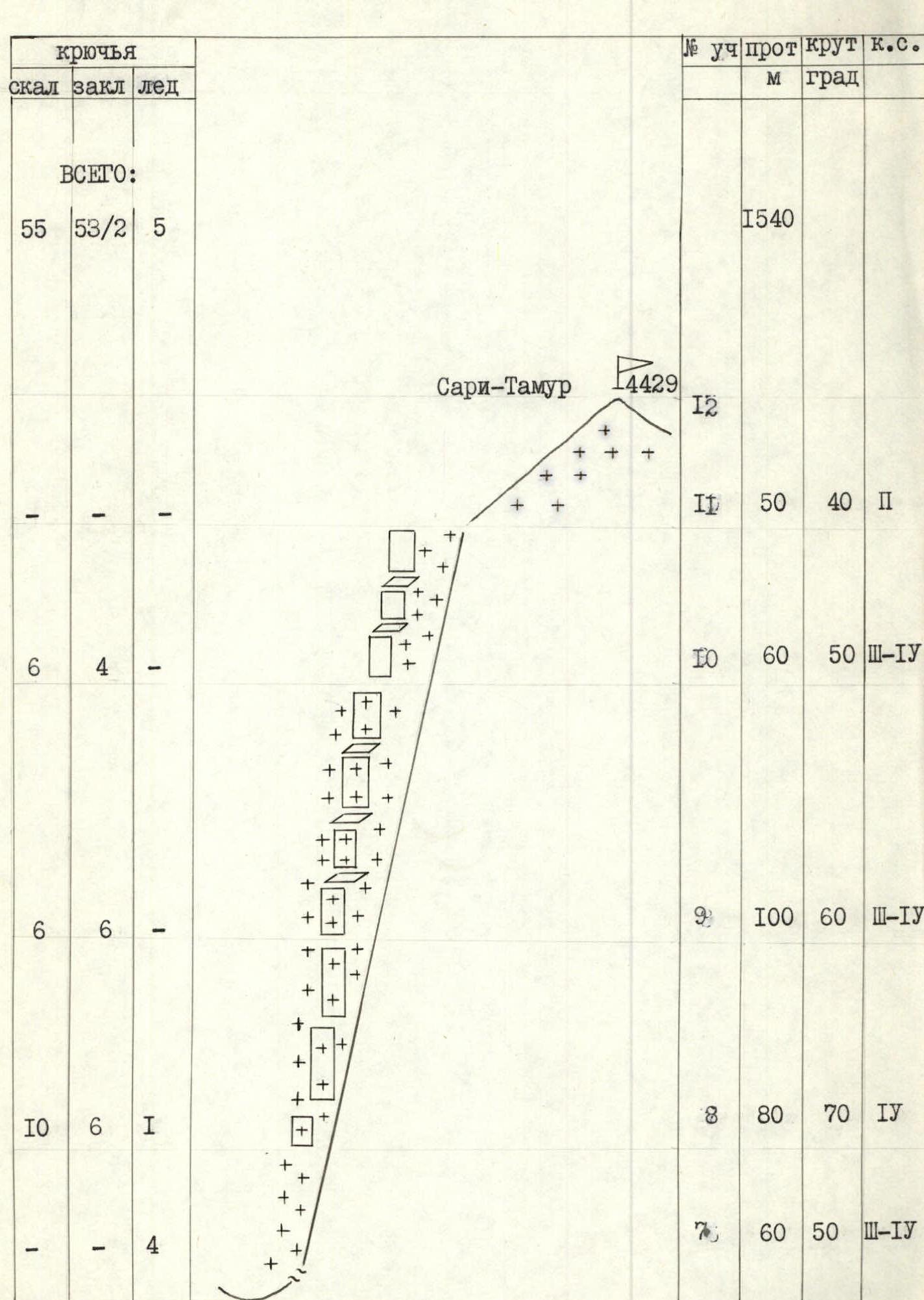
I. Ascent category — technical 2. Ascent area — Pamir-Alay, Zeravshan Ridge. 3. Summit — Sarit-Tamur (4429 m) via the western ridge 4. Proposed — 4B category of difficulty, combined route 5. Height difference — 1179 m. Length — 1540 m. Length of sections 4–5 category of difficulty — 350 m, of which 5 category of difficulty — 100 m. Average steepness of the wall section — 50° 6. Pitons driven: Rock: 55. Nuts: 33/2. Bolt: 2. Ice: 5 7. Climbing hours — 16 (1–2 days) 8. Overnight stays — 1, lying (on a ridge) 9. Group — AUSV "Varzob" The description was compiled based on the analysis of ascents by groups that took this path on descent. The description was compiled by Master of Sports of the USSR Glushko Vyacheslav Ivanovich.

1 — route via the Western ridge 4B category of difficulty (descent path) 2 — Klyunin's route via the left part of the SW wall 5B category of difficulty (1987) 3 — Rusyaev's route via the SW wall 5B category of difficulty (1984)
Photo — I Date of survey — July 27, 1987 Lens — "Lubitel-166"
Height of survey — 3100 m Distance — 3000 m Survey number — I
Map of the "Arch Plateau" area

Conventional signs:
- group's path
- location of the assault camp
- numbers and survey points
Note: in 1987, the map was adjusted according to the data of photopanoramic surveys.
Brief overview of the ascent area
The peaks 4429 (Sari-Tamur), 4292, 4369 (40th Anniversary of Victory) are located in the ridge of the Zeravshan Ridge, in the area of the so-called "Arch Plateau", in the immediate vicinity of the Zamin-Karora area.
The rocks are composed of limestone; the height difference for these peaks is about 1000 m.
In the second half of summer, climbers have to solve the problem of water supply, since there is no water on the routes.
Until recently, the area was rarely visited by climbers. In recent years, its popularity has increased dramatically. Routes have been laid on peak 4369 (peak 40th Anniversary of Victory):
- 1985 — V. Glushko — route 5B category of difficulty
- 1986 — A. Foigt — route 5A category of difficulty
- 1987 — A. Kotelnikov — route 5B category of difficulty
- A. Malinovsky — route 5A category of difficulty
Peak 4292 — 1986 — Z. Lenivkova — route 5A category of difficulty. Sari-Tamur (4429) — 1987 — O. Klonin — route 5B category of difficulty. The first ascent in the area was made by A. Rusyaev's group within the framework of the Central Asia Championship on peak 4429, the route is classified as 5B category of difficulty.
Approaches to the routes from the Dushanbe-Leninabad highway take 3 hours under 4369 and 6 hours under 4292 and 4429 (Sari-Tamur). The ascent begins from the pillar with a mark of 112 km.
Assault camps, as a rule, are located in juniper or birch forest.

Description of the route by sections
Section R0–R1. A series of inclined smooth slabs and "ram's foreheads" leads to the eaves of the SW wall. 900 m, 40°, 3 category of difficulty.
Section R1–R2. Practically vertical wall with two small eaves, passed using IT. Rocks with good relief, there are places for organizing insurance. 20 m, 90°, 5 category of difficulty.
Section R2–R3. Steep inclined internal corner leads to slabs. 40 m, 80°, 5 category of difficulty.
Sections R3–R7. Steep wall with good relief leads to a ridge between peaks 4292 and 4429. 170 m, 60–80°, 3–5 category of difficulty.
Section R7–R8. Ice-snow slope. Crampons required. Insurance via ice screws. Movement from the ridge along the northern side of the crest. 60 m, 50°, 3–4 category of difficulty.
Section R8–R9. Series of steep rock walls, местами залитых льдом, местами заснеженных. Movement in crampons. 80 m, 70°, 4 category of difficulty.
Section R9–R10. Series of snow-covered walls and narrow ledges. 100 m, 60°, 3–4 category of difficulty.
Section R10–R11. Series of short walls and ledges to the left of the snow patch leads to the "roof". 60 m, 50°, 3–4 category of difficulty.
Section R11–R12. Snow slope leading to the summit. 50 m, 40°, 2 category of difficulty.
Descent. Descent via the ascent route.