PASSPORT
- Technical category
- Pamir-Alay, Zeravshan Range
- Peak Akhun (5224) via the right counterfort of the Southeast wall
- Proposed 6B category of complexity, first ascent
- Height difference 1734 m, length 1892 m.
Length of sections with 5–6 category of complexity is 1752 m. Of which 6 category is 829 m. Average steepness of the main part of the route is 82.5°. Average steepness of the route is 76°.
- Use of protection points:
| rock anchors | piton anchors | ice anchors | chocks |
|---|---|---|---|
| 170 | 1 | 36 | 247 |
| 19 | 1 | 0 | 30 |
-
Team's total climbing hours: 52 h 30 min and days — 5
-
Overnights: 1st on a rocky-snowy ledge for 6 people, 3940 m. 2nd on a rocky-snowy ledge for 6 people, 4320 m. 3rd night at the same place as the second (due to bad weather). 4th night on a snow-made platform for 6 people, 4730 m.
-
Climbing and rock climbing qualifications:
Team leader:
- Arkhipov V.A. — Master of Sports, Candidate for Master of Sports
Team members:
- Kokhanov V.P. — Master of Sports, Master of Sports
- Kuznetsov A.V. — Master of Sports, Candidate for Master of Sports
- Kolesnikov K.I. — Candidate for Master of Sports, Candidate for Master of Sports
- Mozharov N.P. — Candidate for Master of Sports, Candidate for Master of Sports
- Naumov N.L. — Candidate for Master of Sports, Candidate for Master of Sports
-
Coach:
- Sapozhnikov Yuri Georgievich
-
Start of the route: July 12. Summit: July 16. Return: July 17.
-
Organization: Krasnoyarsk Kray Sport Committee.
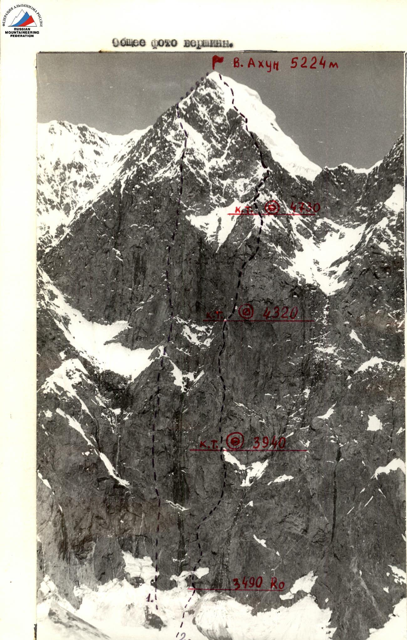
General photo of the peak
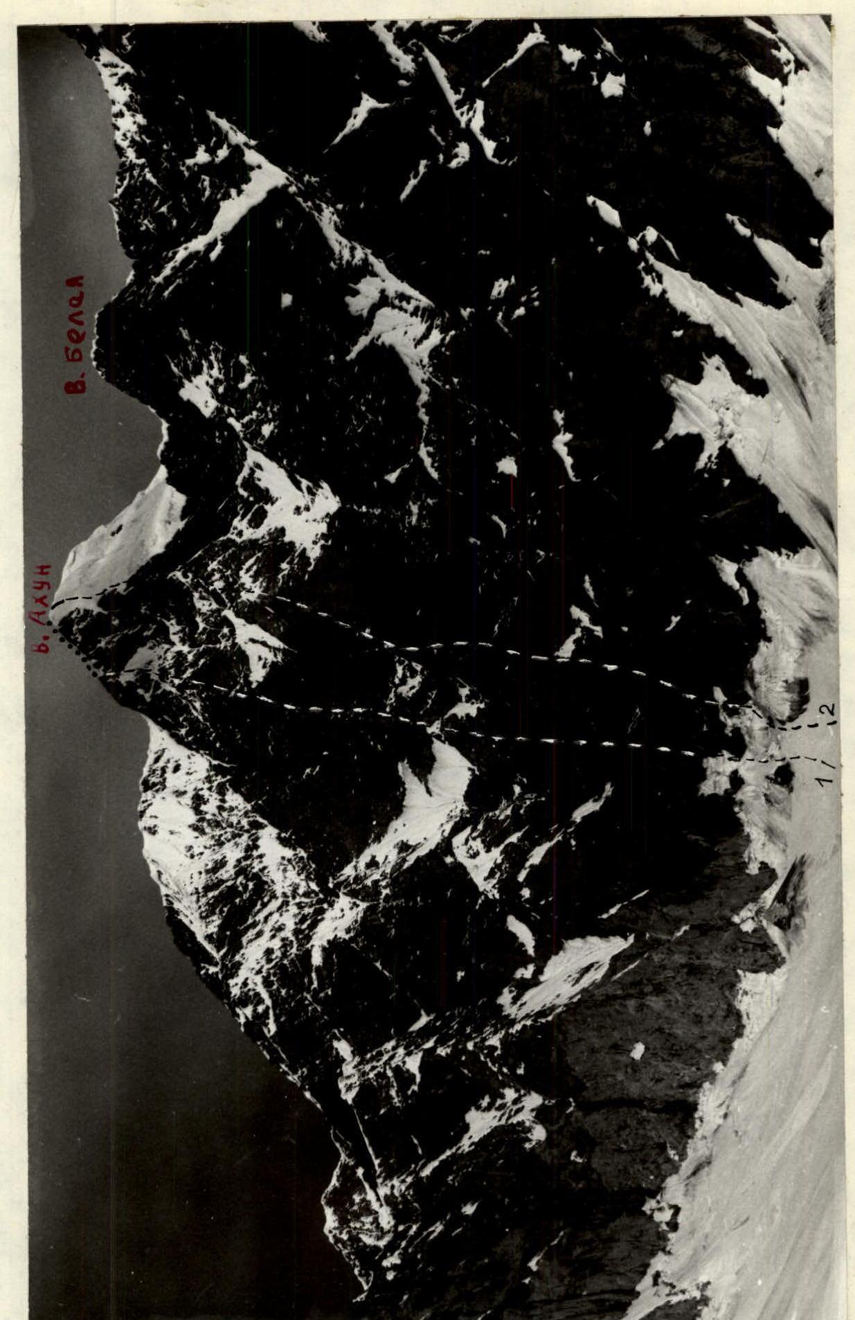
Date taken: July 1, 1988. Time taken: 12:00. Lens: Nikon F=50 mm. Distance: 1.5 km. Height: 3350 m. Shooting point #1. 1. Fedotov's route. 2. Team's route.
Date taken: July 3, 1938. Time taken: 12:00. Lens: Nikcz F=50 mm. Distance: 2 km. Shooting point 33. Height: 3650 m.
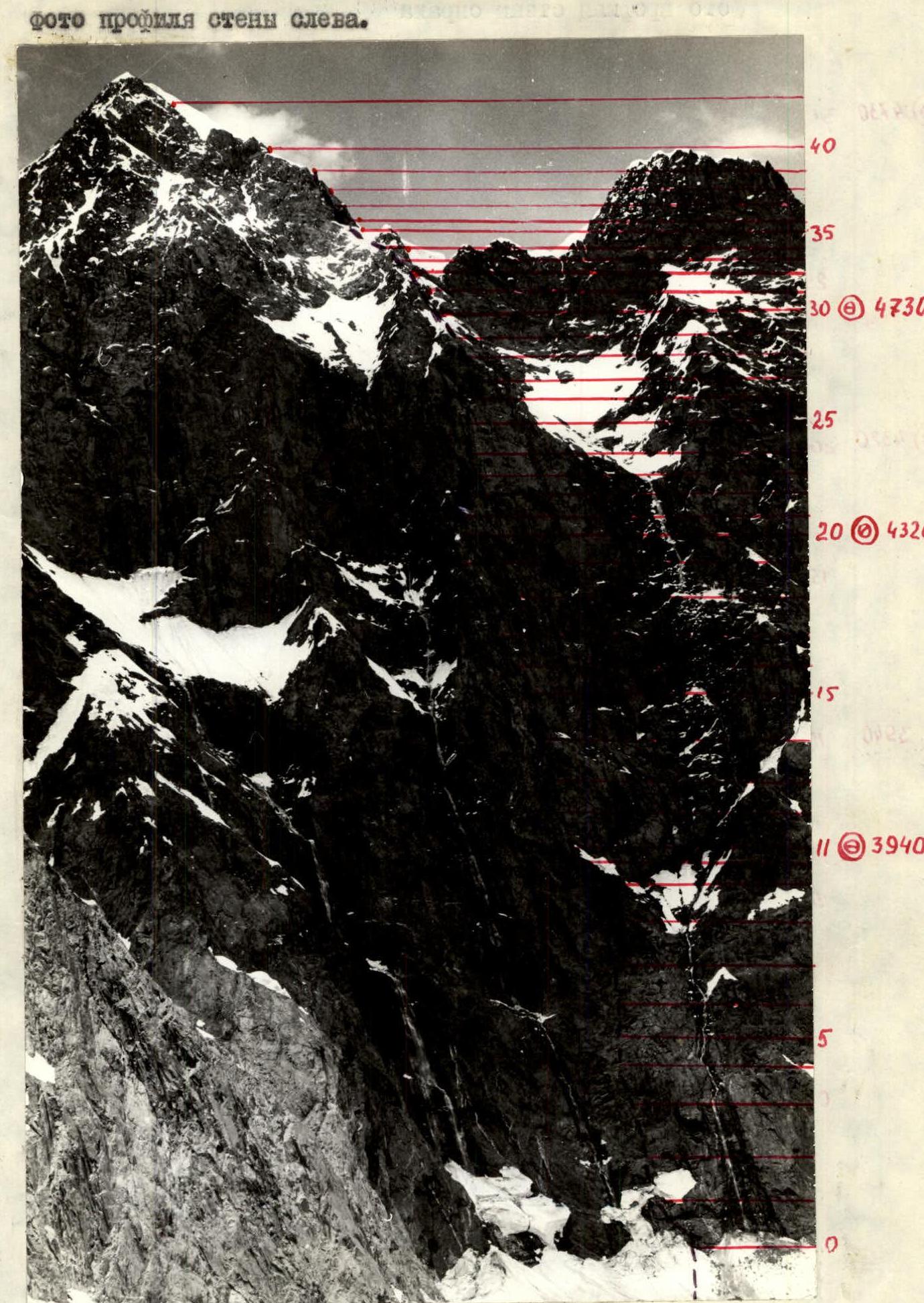

Left wall profile photo
Date taken: July 3, 1988. Time taken: 12:00. Lens: Nikor F=50 mm. Distance: 2 km. Height: 3650 m. Shooting point #3.
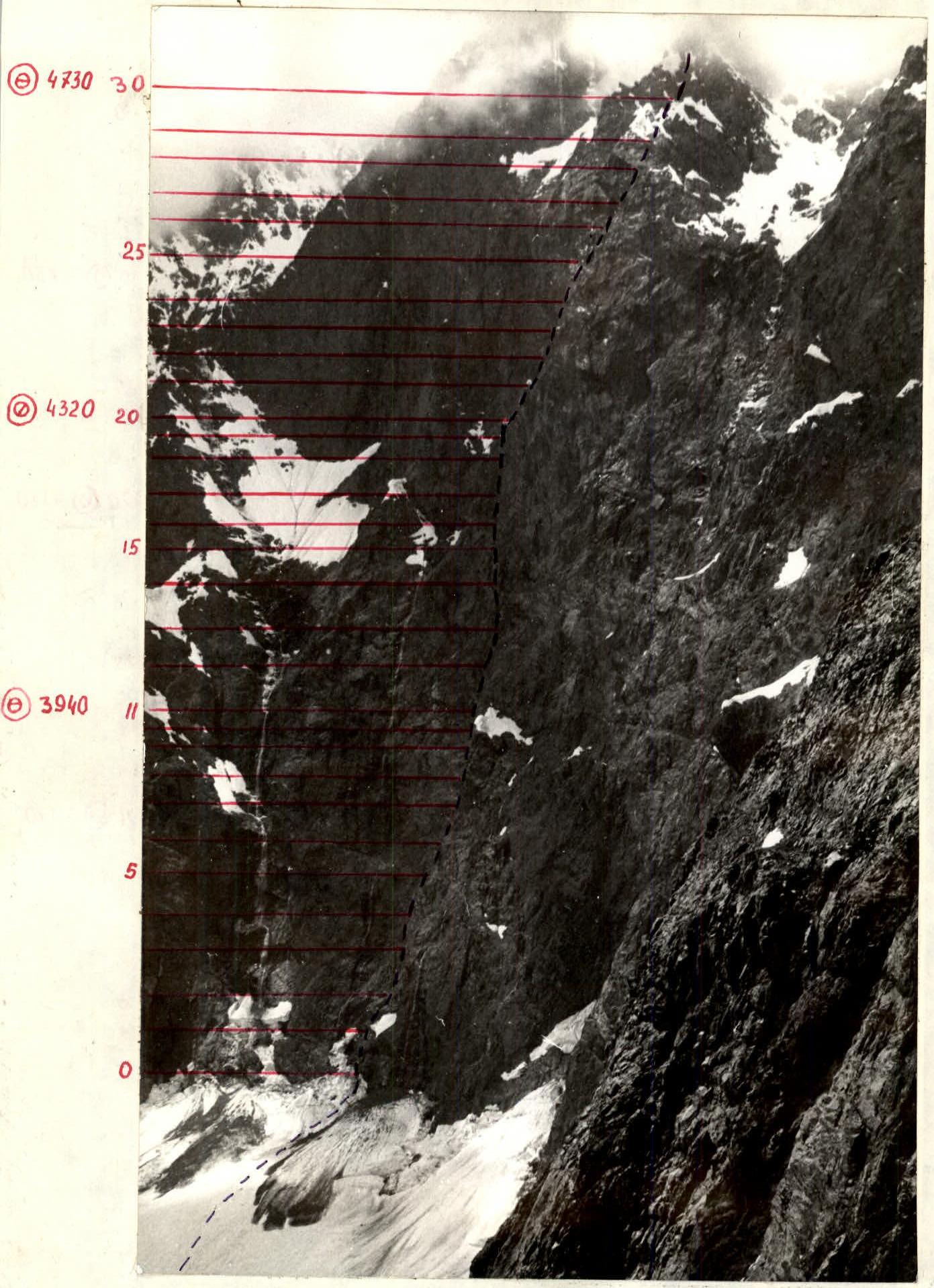
Right wall profile photo
Date taken: July 12, 1988. Time taken: 12:00. Lens: Nikor F=50 mm. Distance: 1 km. Height: 3600 m. Shooting point #2.
Area photopanorama
Date taken: July 5, 1988. Time taken: 13:00. Lens: Nikor F=50 mm. Distance: 2 km. Height: 3350 m. Shooting point #4. 1. Fedotov's route. 2. Team's route.
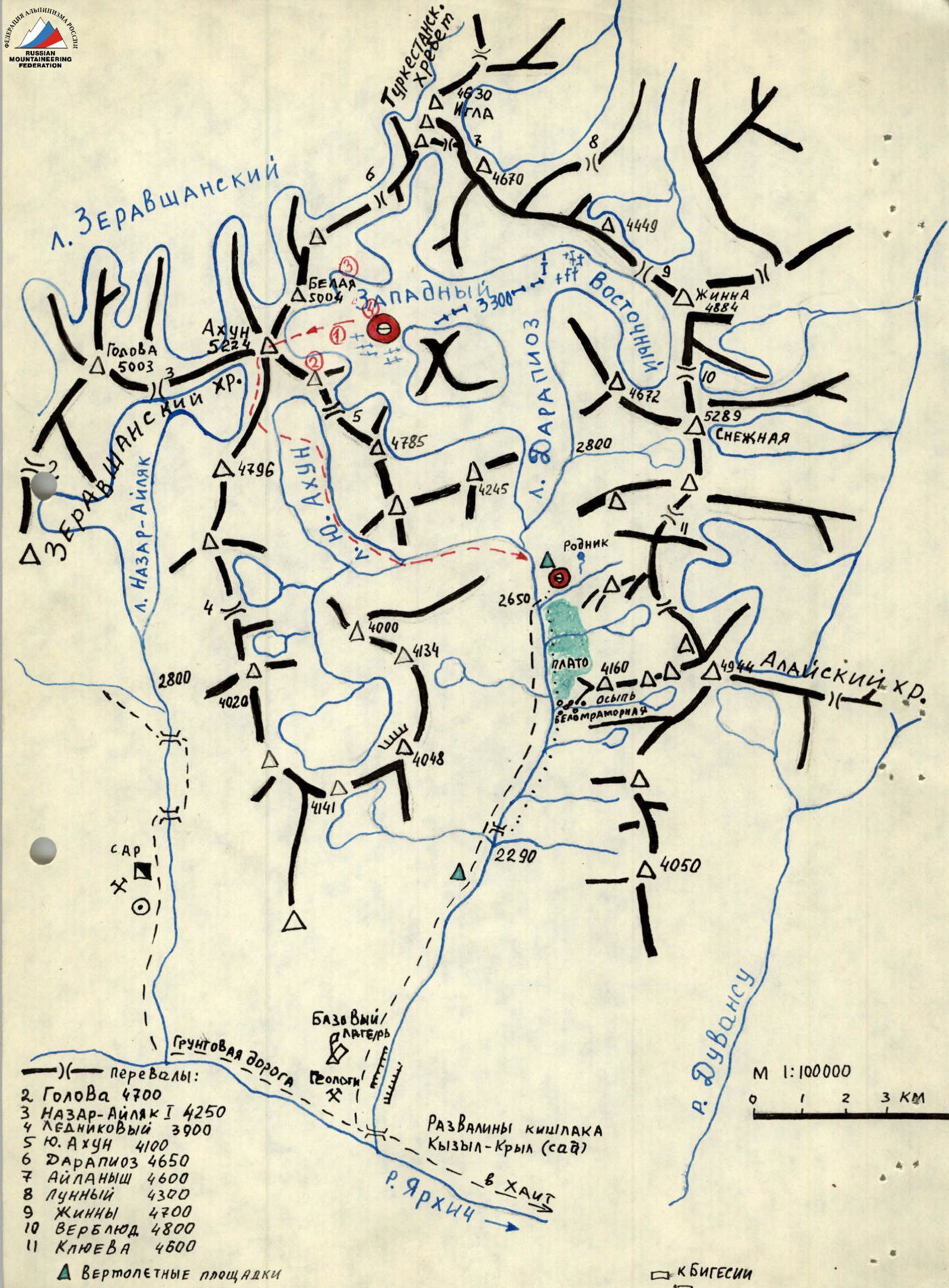
Brief overview of the ascent area
A route of 6B category of complexity was laid to peak Akhun (5224) in 1980 by a team led by Fedotov (LenVO training). This area was also visited by LenVO training in 1982. In 1983, a team led by Ivashchenko A. made a second ascent of the 6B category route via the center of the Southeast wall to peak Akhun. As seen from the data, the area is not frequently visited by climbers.
To reach the ascent object, one can travel from Dushanbe (via the Dushanbe-Jirgital road) to the village of Khait (260 km) by car. From the village of Khait, take a dirt road along the Yarhich river valley to the Darapioz river (30 km) by car. Here is a geologists' camp, where cars can reach, and this is where the base camp was set up. Up the Darapioz valley, 15–18 km to the intermediate camp near the glacier tongue, 7–8 hours. The trail follows the right (orographically) bank of the valley and crosses to the left bank via a snow bridge 6–7 km below the glacier tongue. The intermediate camp is located on the left (orographically) bank of the Darapioz river, at an altitude of 2650 m. There is a spring, a clearing, and a green meadow. Rest here is quite adequate. From the intermediate camp, ascend the glacier, sticking to its right side, to the confluence of the East and West Darapioz glaciers (2 hours). Cross the glacier from right to left and continue ascending roughly in the middle of the West Darapioz glacier. The glacier is open and crevasse-free. Overnights are on moraine outcrops under peak Akhun. From the intermediate camp to the overnight stays on the moraine takes 3.5 hours, and the approach to the start of the route from the overnight stays takes 1 hour. Peak Akhun is easily recognizable at first glance, matching the photograph.
The area's peculiarity is its highly unstable weather. The mountains in the area are composed of schist, gray granite, basalt, and magmatic rocks. The area is highly seismically active.
The peculiarity of the local flora is the abundance of "yugan" grass, which causes severe chemical burns on exposed skin; burns are especially severe on moist, exposed skin (in the rain villagers).
Team's tactical actions
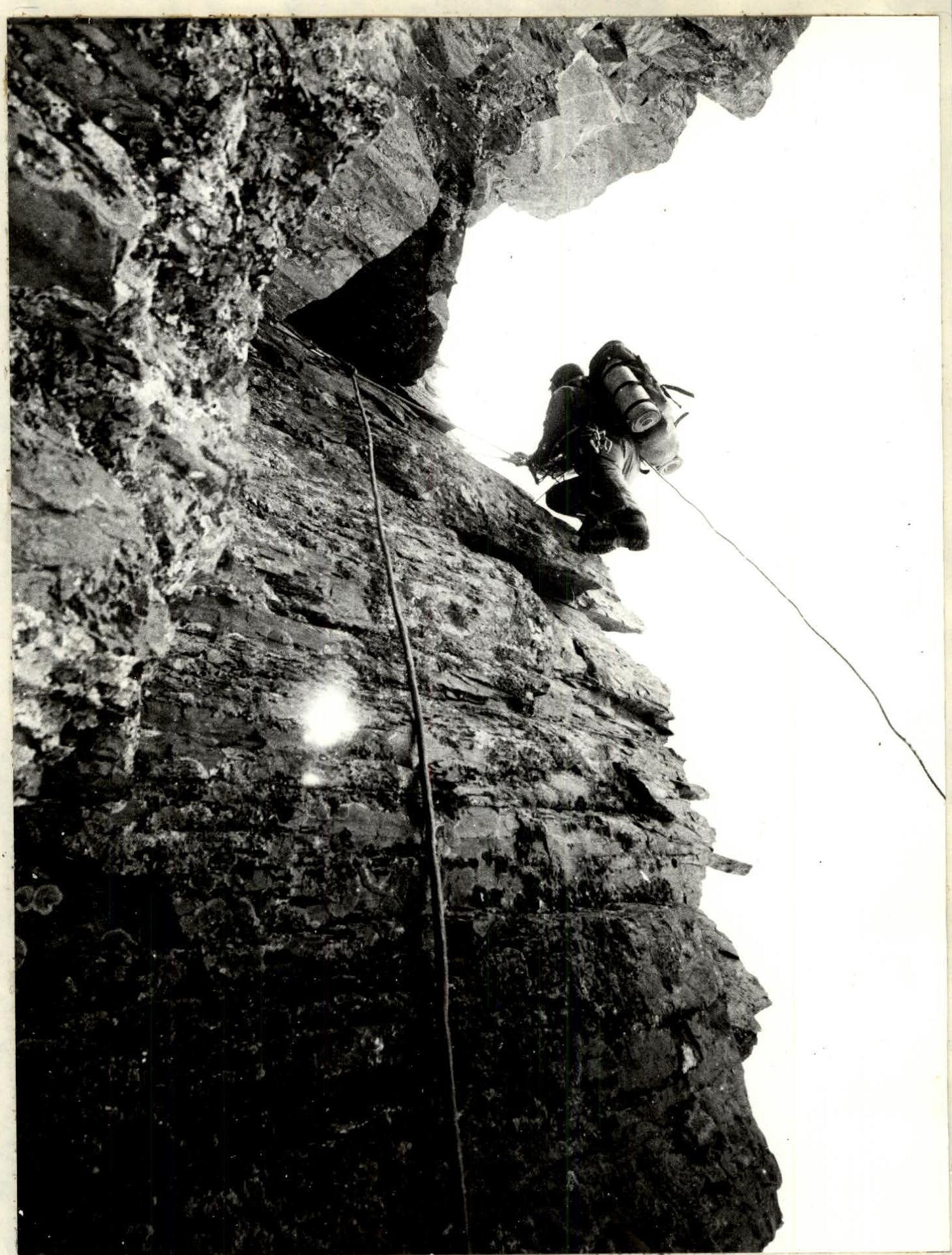
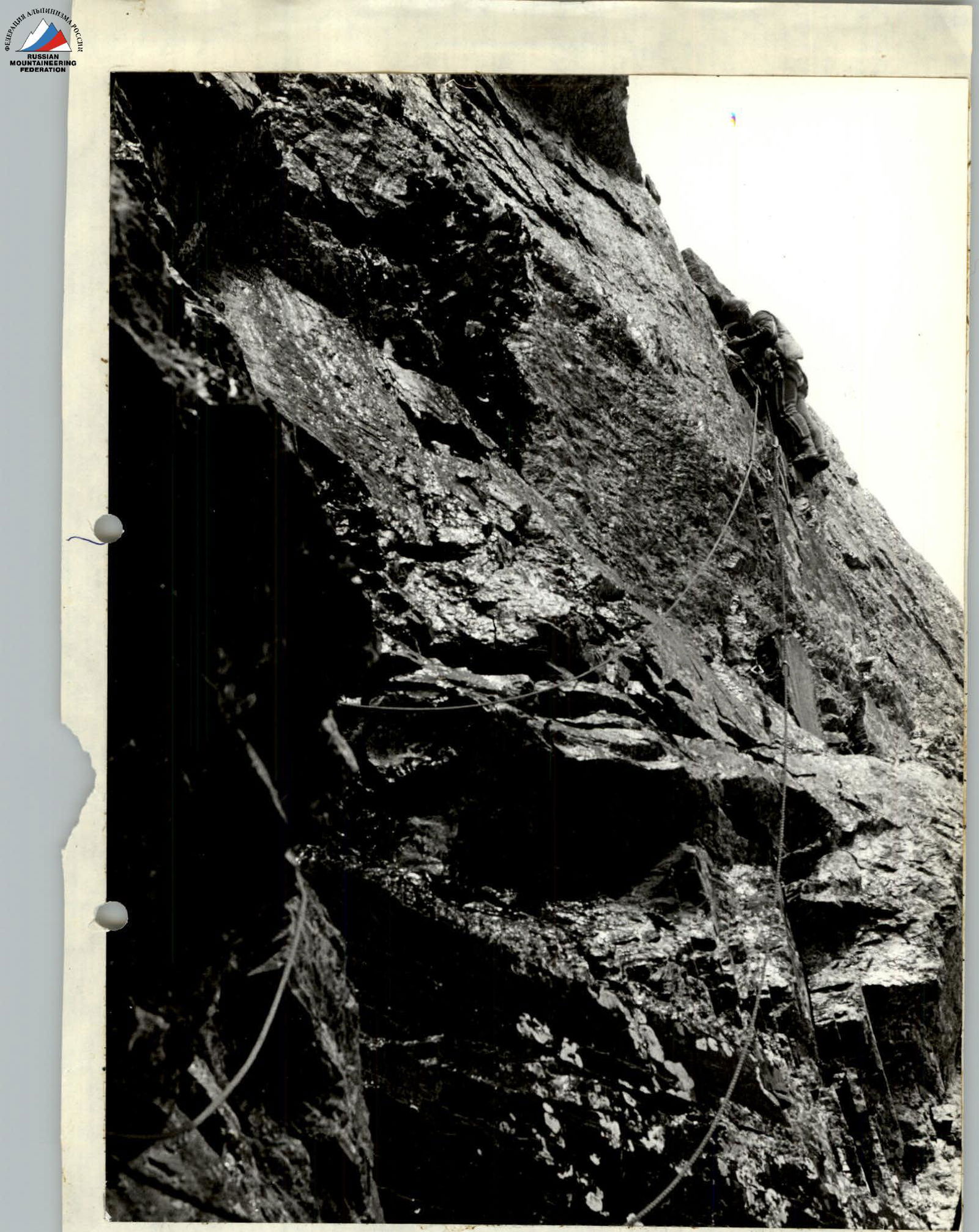
Tactical actions were carried out in accordance with the tactical plan, which was fully implemented during the ascent, with no deviations. Organization of rope team movement, their interaction, and leader changes were conducted according to the tactical plan. To ensure safety, the first climber moved without a backpack on double UIAA ropes using chocks, rock anchors, ice anchors, and piton anchors — see photos I, II. Belay points consisted of at least three blocked anchoring points — see photo II. Blocking was done using the Saratkin method with automatic equal load distribution on each anchoring point. Although the relief allowed the entire group to gather at belay points, it was not possible to gather more than 2–3 people. There were also hanging belay points (see UIAA diagram). Everyone in the group moved along the rope with top-rope protection (to prevent possible rockfall) — see photos 4, 5, 8. Movement on processed sections was done with bottom-rope protection — see photos 2, 6. The movement regime throughout the day was continuous; for nutrition, individual packs with high-quality products were used. Hot meals were consumed during overnight stays. The fourth team member recorded the route and took photographs as possible during the ascent.
The first overnight stay was organized on a snow-slab platform, R11, on a hacked-out rocky-snowy ledge under a corniche for 6 people in a sitting-semi-reclining position. The second overnight stay was on a snow-rocky ledge, R20, under a corniche in a tent for 6 people in a semi-reclining position — see photo 10. The platform under the tent was 60% made of snow. Due to worsening weather (rain throughout the night and morning, see movement graph), the tent was not taken down the next day, and the team worked on processing the route. The bad weather did not break the team's morale, although it added complexity. For the fourth overnight stay, having gained experience in making snow platforms, a convenient and safe platform was created under a corniche, with a tent for 6 people in a semi-reclining position, R30. The fifth overnight stay was on the descent, just below the summit, on a snow dome.
The route was completed with a sufficient physical and technical reserve. When encountering problematic sections, the team refined the planned variants and chose the most logical and safe path. Overnight stays were organized with at least 2 hours of daylight remaining, allowing for quality rest and preparation for the next day's movement. The lead pair processed the route, while the other four set up the tent and prepared dinner. All sections of the route were traversed reliably, with necessary safety measures in place for all team members. A rescue team with a medic was stationed at the intermediate camp. Interaction was organized with LenVO training, led by Dzhiraev. The LenVO base camp was located near our base camp; LenVO climbers were ascending peak 4160 and planned first ascents in the Darapioz valley area. Observers were stationed under the route. A "Kamaz" vehicle was kept on standby at the base camp. There was communication with geologists who had a helicopter at their disposal. Radio communication with the team was maintained according to schedule and was consistently stable.
There were no accidents or injuries.
As part of new equipment (for the team), a platform with a calandra-avizantova tent was prepared and manufactured. The platform was not taken on the route as suitable overnight locations were found. The tent has three setup options and, when taken to the wall, performed exceptionally well.
Table of food products and fuel
| Product Name | Total weight, kg |
|---|---|
| Bread | 1.5 |
| Boiled potatoes | 1.0 |
| Salted pork fat | 0.5 |
| Smoked pork fat | 0.5 |
| Sprats | 0.75 |
| Dried smoked sausage | 1.2 |
| Instant coffee | 1.0 |
| Chocolate | 1.0 |
| Groundnuts | 0.8 |
| Pine nuts | 1.0 |
| Dried apricots | 0.8 |
| Raisins | 0.8 |
| Condensed milk | 1.2 |
| Tea | 0.05 |
| Buckwheat groats | 0.3 |
| Canned stew | 1.0 |
| Cookies | 0.4 |
| Caramel candies | 0.5 |
| Dutch cheese | 0.5 |
| Salted red fish | 0.5 |
| Total | 14.4 |
| "Krasmash" gas stove, 2 pcs. | 2.0 |
| "Krasmash" gas cylinder | 0.8 |
| Food and fuel total | 17.2 |
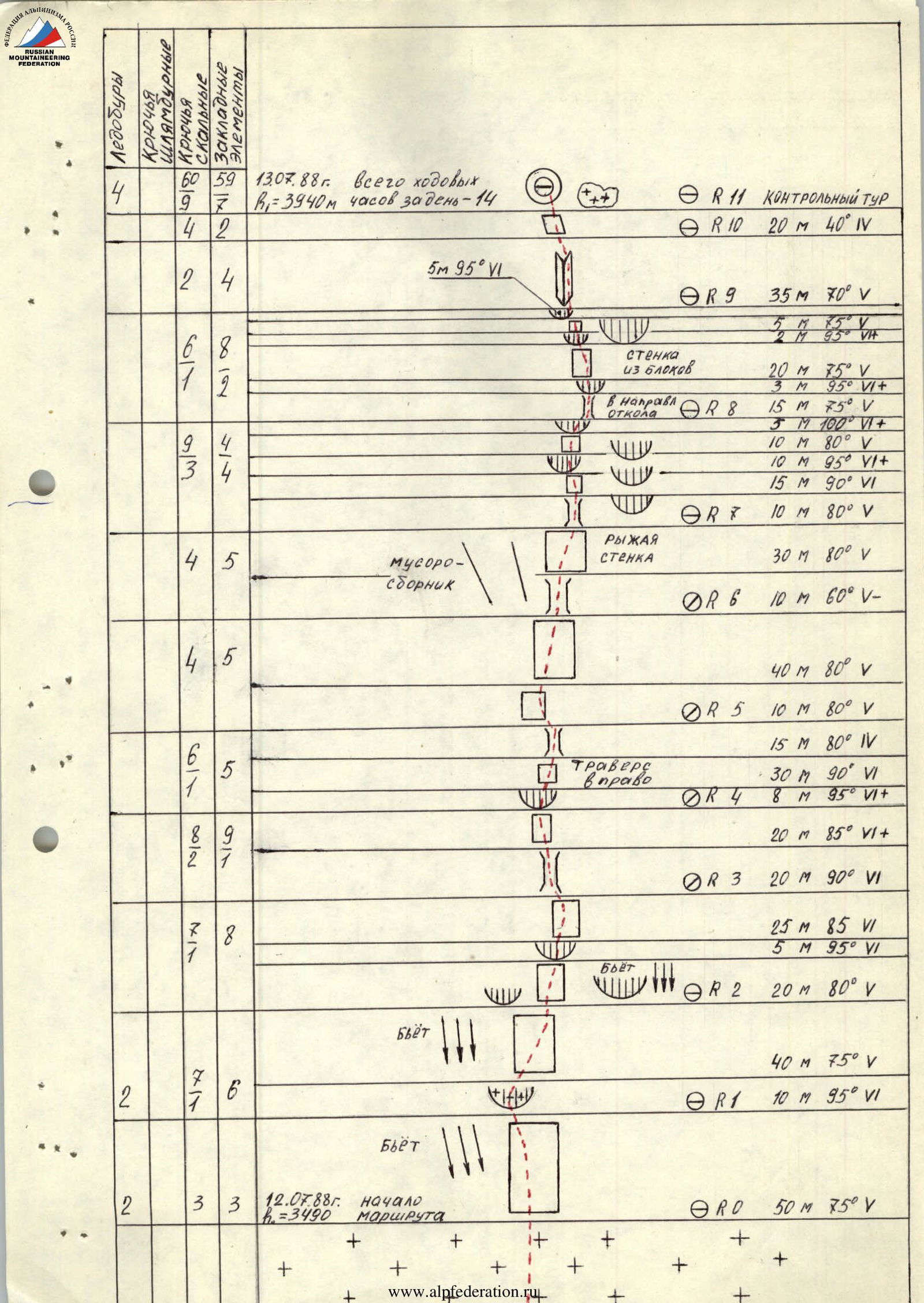
Technical description of the route by sections (diagram)
July 13, 1988. Total climbing hours for the day: 14. Height R1: 3940 m.
- R0: 50 m, 75° V. Start of the route on July 12, 1988, h=3490 m.
- R1: 10 m, 95° VI. Water spout.
- R2: 20 m, 80° V. Water spout.
- R3: 20 m, 90° VI.
- R4: 8 m, 95° VI+. Traverse right 30 m, 90° VI.
- R5: 10 m, 80° V. 15 m, 80° IV.
- R6: 10 m, 60° V–. Rubble collector. Red wall 30 m, 80° V.
- R7: 10 m, 80° V.
- R8: Towards the outcrop. 15 m, 90° VI. 10 m, 95° VI+. 5 m, 100° VI+. 15 m, 75° V. 3 m, 95° VI+. 20 m, 75° V. 2 m, 95° VIА. 5 m, 75° V.
- R9: 35 m, 70° V. 5 m, 95° VI.
- R10: 20 m, 40° IV.
- R11: Control point.
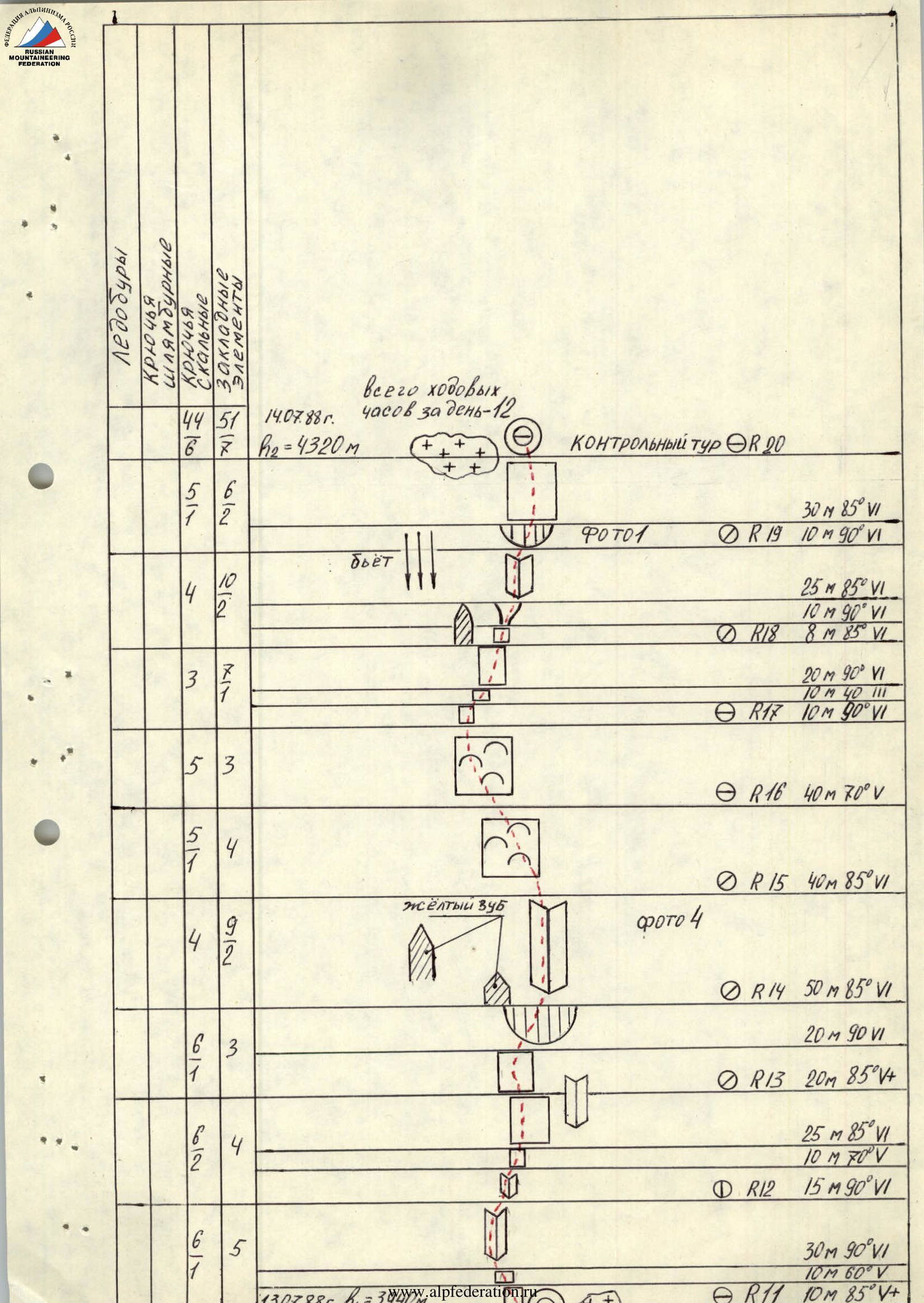
July 14, 1988. Total climbing hours for the day: 12. Height h=4320 m.
- R11: 10 m, 85° VI+. Water spout.
- R12: 15 m, 90° VI. 10 m, 70° V. 25 m, 85° VI.
- R13: 20 m, 85° VI+. 20 m, 90° VI.
- R14: 50 m, 85° VI. Yellow tooth.
- R15: 40 m, 85° VI.
- R16: 40 m, 70° V.
- R17: 10 m, 90° VI. 10 m, 40° III. 20 m, 90° VI.
- R18: 8 m, 85° VI. 10 m, 90° VI. 25 m, 85° VI.
- R19: 10 m, 90° VI. Photo 1.
- R20: Control point. 30 m, 85° VI.
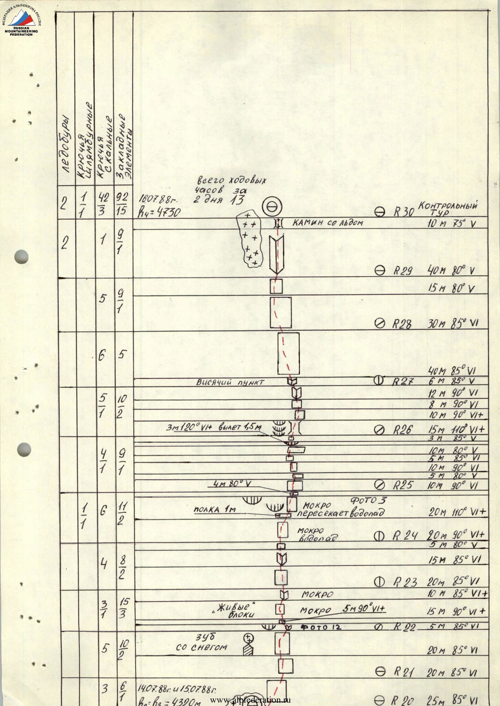
July 16, 1988. Total climbing hours for 2 days: 13. Height 4730 m.
- R20: 25 m, 85° VI.
- R21: 20 m, 85° VI.
- R22: 5 m, 85° VI. Photo 12. With snow. "Living" blocks. 15 m, 90° VI+. 20 m, 85° VI.
- R23: 10 m, 85° VI+. Wet. 20 m, 85° VI.
- R24: 5 m, 80° V. Wet. Waterfall. 20 m, 90° VI+.
- R25: 10 m, 90° VI. 5 m, 80° V. 10 m, 90° VI. 5 m, 85° VI. 10 m, 80° V. 3 m, 85° V. 15 m, 110° VI+. Wet. Photo 3 intersects the waterfall. Ledge 1 m. 4 m, 80° V.
- R26: 10 m, 90° VI+. 8 m, 90° VI. 12 m, 90° VI. 6 m, 85° V. 40 m, 85° VI. 3 m, 120° overhang 1.5 m.
- R27: Hanging belay point. 15 m, 80° V. 40 m, 85° VI.
- R28: 30 m, 85° VI.
- R29: 15 m, 80° V. 40 m, 80° V.
- R30: Control point. Chimney with ice. 10 m, 75° V. 30 m, 80° V+.
Total climbing hours: 52 h 30 min. 43 climbing hours per day: 13.30. h=5224 m peak Akhun.
- R31: 5 m, 80° V+. 15 m, 45° IV. 5 m, 80° V. 20 m, 85° VI.
- R32: 3 m, 30° III. 10 m, 75° V+.
- R33: 10 m, 85° V+. 10 m, 50° V. 50 m, 50° V.
- R34: 10 m, 90° VI. 20 m, 95° VI. 10 m, 85° V+. 35 m, 80° V.
- R35: 50 m, 80° VI. Ice-filled couloir of a gendarme, hanging belay point. Left slope steepness 60°. Avalanche hazard.
- R36: 40 m, 60° V–.
- R37: 80 m, 40° III. Stone with a "crown".
- R38: 110 m, 45° V–.
- R39: 80 m, 60° V.
- R40: July 16, 1988. h=5224 m peak Akhun.
Route description by sections
A certain difficulty is presented by the transition from snow through the bergschrund to the steep, 75° rocks — point R0. Here is the start of the route. The path is clearly visible — along the relief wall between two smooth slabs.
Section R0–R1 leads to a flattening before a snow corniche. To the left of the route, water spouts; the flattening is also being drilled. The snow corniche of section R1–R2 is passed directly. Later, in about 5 days, a passage between the snow and the rock might be possible. To the left, ledges are visible, but it's undesirable to go that way — it's rockfall-prone. The corniche of section R2–R3 is passed on the left side, with good relief. The wall has slots for shovel-shaped anchors, monolithic. Section R3–R5 — bypassing the red mirror on the left. Monolithic, not drilled. Section R5–R7 — monolithic rocks, passable with traversing to the right. Deviating left is not advisable — rockfall hazard. At the end of the section, there are destroyed rocks — "loose rocks". Section R7–R8 — we move to the left of the wall with three cornices, not being "pulled" left or right. Movement upwards towards the outcrop. Anchors go in well. In the upper part of section R8–R9 — a wall with a steepness of 75°, live blocks. Move very carefully. The cornices of the section are passed directly, with good relief. Section R9–R11 — movement along the snowfield; it's undesirable to step on the snowfield — you might slide off. At the top of the snowfield is an overnight stay, under a corniche, with a hanging control point in a tin can. The upper part of section R11–R12 — an internal corner, difficult climbing. The belay point is inconvenient. Section R12–R13 is overhanging with an internal corner; we move along the left part. The corner turns into a wall with a steepness of 85°, small footholds, difficult climbing. To the right, it's easier, but above, the path is blocked by cornices. The corniche of section R13–R14 is passed directly; the rocks have good relief. The belay point is to the right of the tooth with yellow streaks — an excellent landmark. Section R14–R15 — a large internal corner, good relief, monolithic, but steep — 85°. Climbing is difficult. Section R15–R17 — walls like "ram's foreheads", smooth, with small footholds. On section R17–R18 — movement towards the outcrop; in the middle part of the section, there's a flattening to 40°. Walls have many slots; anchors and chocks go in well. Section R18–R19 — movement along the edge of the counterfort wall. We don't step onto the counterfort — the wall spouts from the waterfall. The section is complex, with destroyed rocks. To the right are wet cornices. Therefore, we move through the overhang upwards and through the wall, where we can already see the overnight stay site. The wall is monolithic, has relief, and anchors go in well. Overnight stay. Hanging control point.
Section R20–R21: destroyed steep rocks, some wet. It's practically impossible to set up an overnight stay on the snowfield of section R21–R22 — it's too steep.
Section R22–R23: live blocks, wet rocks, small footholds. Zigzagging right-left-right, choosing a path and aiming for the base of the internal corner.
Section R23–R24: climbing is less tense, relief is richer.
Section R24–R25: the wettest section. It's intersected by a waterfall. Rocks are slippery, covered with slime, relief is limited to small footholds. Climbing is complex; a piton anchor is hammered in.
Section R25–R26: movement towards a depression in the wall. Cornices alternate with walls. Steep, extreme climbing.
Section R26–R28: an overhang that forms a niche or depression. A path is visible to the left along the internal corner, but above it's wet and the corner is blocked by a corniche. It's simpler to go straight up, although the climbing is extreme here too.
Section R28–R30: exit to a flattening. The wall part of the route is completed, but complex climbing will still be encountered.
Section R30: overnight stay, hanging control point in a tin can.
Section R31: begins movement along the counterfort ridge.
Section R34–R35: approach to a gendarme. The gendarme is passed directly.
Section R35–R36: approach to an ice-filled couloir. Climbing is complex; rocks are covered with ice. When observing the route, this section didn't seem problematic. Perhaps the bad weather made it more complicated. Movement in crampons.
The couloir divides the gendarme in two — section R37–R38. Movement in crampons; protection using chocks, rock anchors, and ice screws.
Section R38–R39: approach to a stone with a "crown". Snow.
Section R39–R42: snow, some ice. Steepness increases towards the top. The ice corniche is bypassed on the left.
The summit! The control point is on rocky outcrops.
Technical description of the route
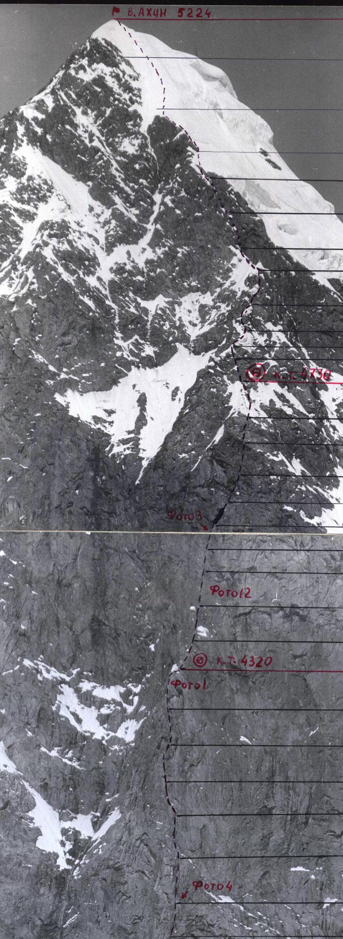
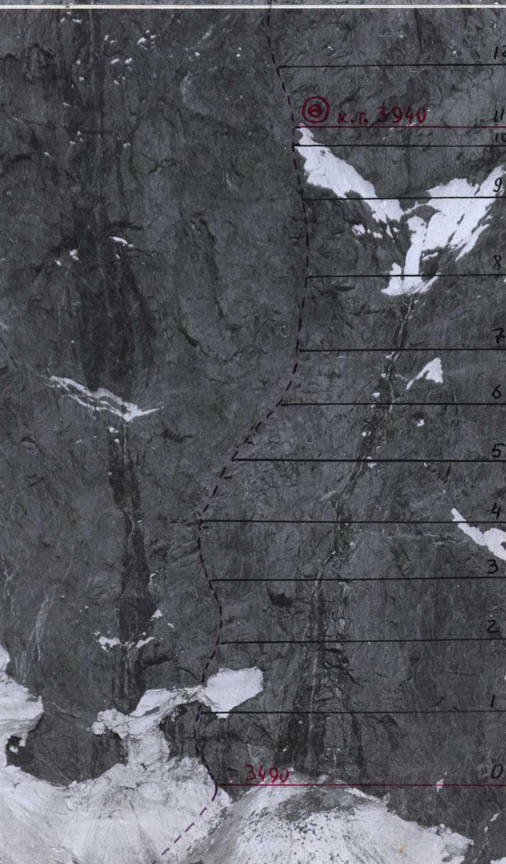
Photo 7. July 16, 88. Movement along a snowy slope, Section R35–R36. Lens: "Russar".
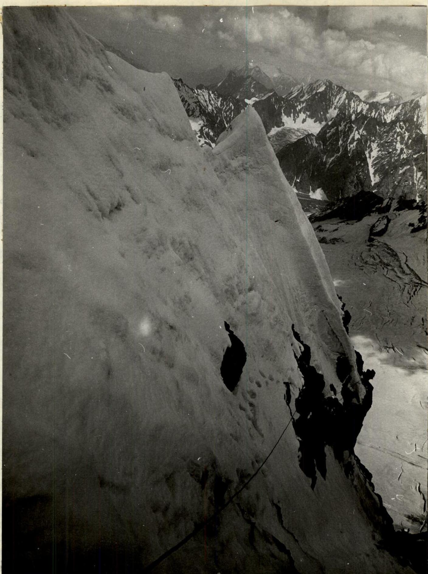
Photo 11. First climber moving without a backpack on a double UIAA rope. Belay point on three blocked points. Lens: "Russar".
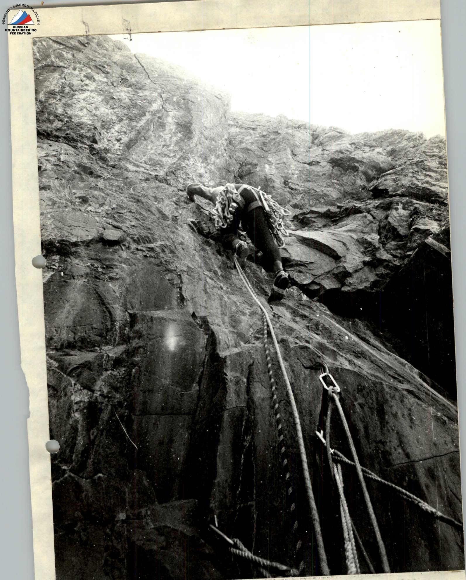
Photo 12. Cornice of section R22–R23. Lens: "Russar".