
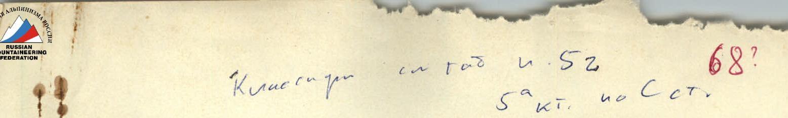
68
To the classification commission of the USSR Alpinism Federation
The route was included in the table according to a note made by V. Tselovakhin's group (1968), which passed the route to the ridge via Svido. (They named it via the S wall). The commission erroneously believed that both groups had passed the same route (this route — via the NW wall). The commission did not have S. Morozov's report.
- V. Shulepin
- April 20, 1984
Fann Mountains
Description of the first ascent: Skalnaya Stena peak – 5112 m, combined route via the north-west wall, 5B category of complexity. Completed on August 8–12, 1967, by a group organized by the sports club "GRANIT". Ascent leader — Master of Sports MOROZOV S.A.
Description compiled by: © V. Mironov, V. Bastrikov
Chelyabinsk Regional Alpinism Federation, 1967
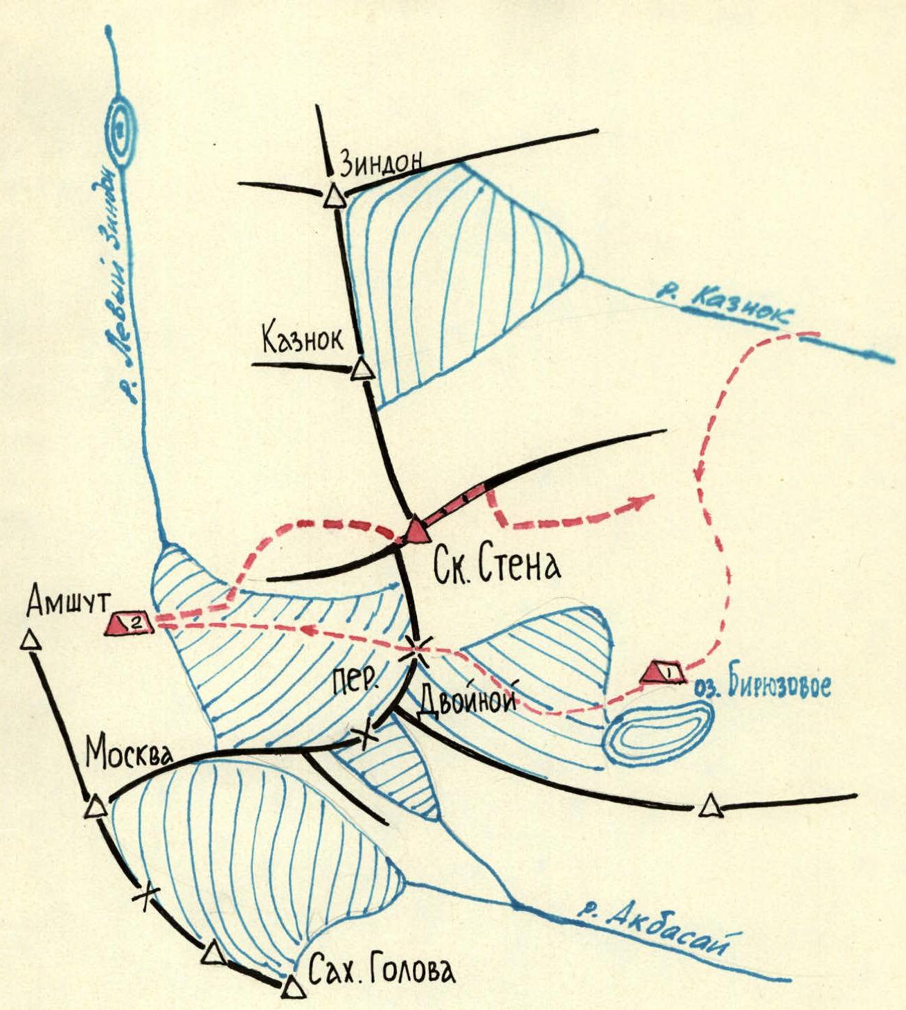
- Biwaks: 1 — near Biryuzovoe lake, 2 — observers'
- Approaches
- Route of the assault group
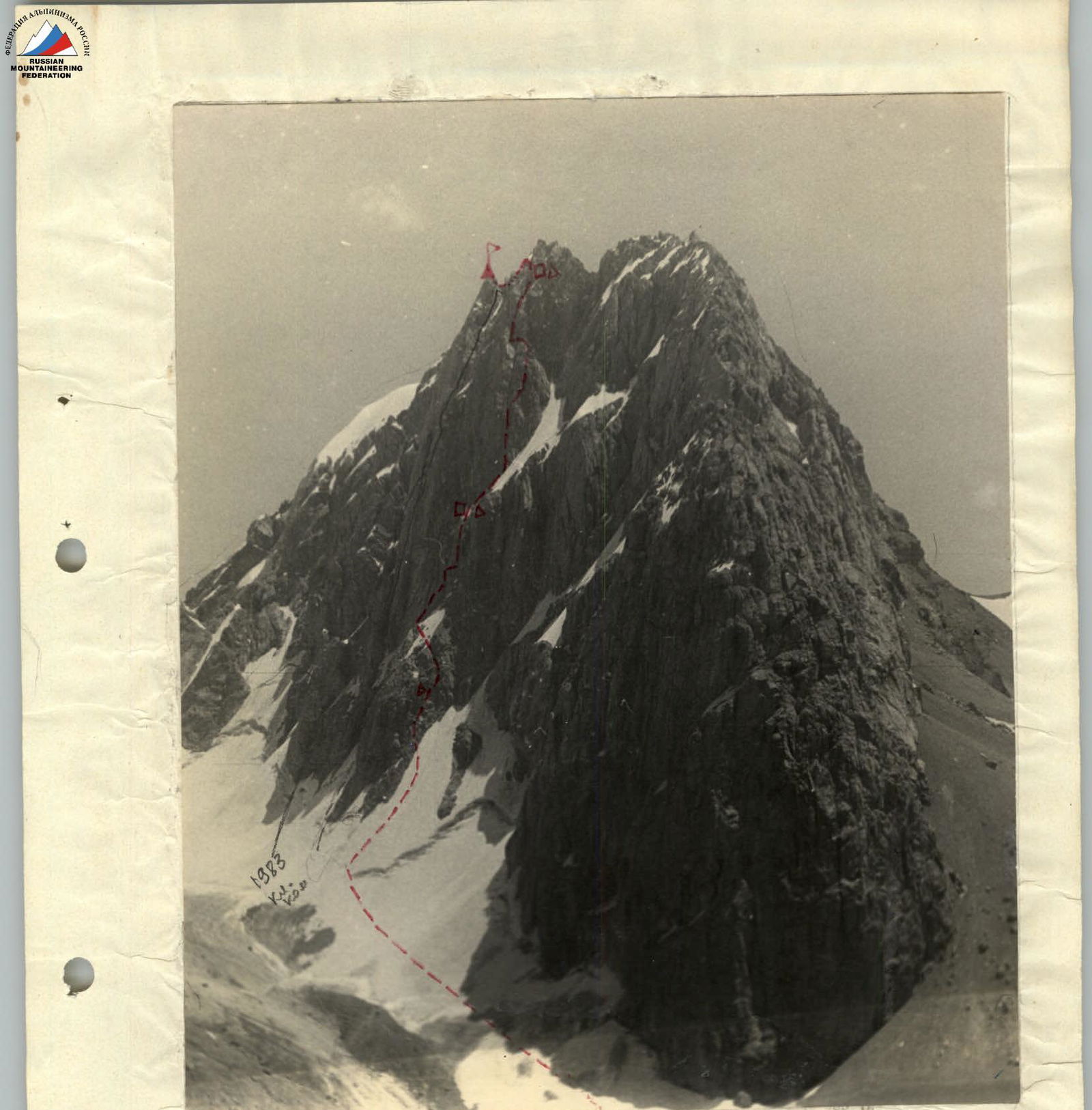
Skalnaya Stena Peak
north-west wall, view from the slopes of Amshut peak.
Movement of the group, overnight stays, control cairn, summit cairn.
Skatnaya Stena peak, elevation 5112 m, is located in the Fann Mountains, north of the "Dvoynoy" pass, in the watershed ridge. Nearby peaks include:
- to the north-east — "Kaznok" peak;
- to the west — "Krasnaya Moskva" peak.
The nearest settlement — Sary-Tog village — is 10 hours walking distance from Skalnaya Stena peak.
From the "Varzod" alpine camp, located on Iskander-Kul lake, to Skalnaya Stena peak — 12 hours walking distance.
Skatnaya Stena peak is an east-west trending ridge with sheer drops:
- to the west — a short ridge to the "Amshut" glacier;
- to the north and south — walls.
The eastern ridge from the highest point gradually descends and transitions into grassy slopes on the right bank of the Kaznok river.
The north-west wall of the peak has a significant (about 1300 m) height difference from the base to the highest point. The average steepness is 70–80°. There are icy sections on the wall.
The area is well-studied: pre-war expeditions led by E. Kazakova, Mukhin, and Gusev explored the region. A group from a Kazakh alpinist club conducted reconnaissance of routes to Skalnaya Stena peak but did not climb it.
Climbing conditions in the Fann Mountains are characterized by stable, good weather. There is little snow in July. Icy sections are difficult to traverse.
Since there were no previous ascents to Skalnaya Stena peak, significant attention was devoted to:
- reconnaissance of approaches to the peak;
- studying ascent routes;
- studying descent routes.
On August 2, 1967, a group consisting of Morozov S.A., Muravyev E.A., Mironov V.I., and Bastrikov V.P. departed from the base camp on the Kaznok river to Skalnaya Stena peak to scout the approach to the peak, overnight locations, and ascent and descent routes from the south.
On August 5, 1967, a group consisting of Muravyev E. and Mironov V., from an overnight stay on the shore of Biryuzovoe lake, conducted a survey of the peak from the west and north.
On August 6, 7, and 8, 1967, a group consisting of Muravyev E., Mironov V., and Bastrikov V. went to the slopes of Amshut peak and conducted observations through binoculars of the condition and behavior of the north-west wall. A final ascent route was chosen.
Based on the reconnaissance, a tactical ascent plan was developed, which included:
- an early departure from the base camp on the Amshut glacier moraine to pass the first icy section before the sun hit it (after 12:00 PM, it was exposed to rockfall);
- reliance on seated overnight stays due to the lack of identified overnight locations during the binocular reconnaissance;
- presence of a safe location for an overnight stay regarding rockfall when exiting to the second icy section (under the counterfort).
Descent was planned in three variants:
- via the eastern ridge, then north to a saddle above the northern branch of the Amshut glacier;
- via the western ridge, then south to the "Dvoynoy" pass;
- via the eastern ridge and descent down the southern wall.
The third descent variant was implemented. Group members: MOROZOV Sergey Aleksandrovich — Master of Sports, MURAVYEV Evgeny Aleksandrovich — Master of Sports, MIRONOV Viktor Ivanovich — 1st sports category, BASTRIKOV Vyacheslav Petrovich — 1st sports category.
The group composition remained unchanged during the ascent.
On August 9, 1967, at 5:00 AM, the group departed from the bivouac on the Amshut glacier moraine. At 6:00 AM, the group approached the start of the route and roped up. The rope teams formed as follows:
- first rope team: Bastrikov V.P. — Mironov V.I.;
- second rope team: Morozov S.A. — Muravyev E.A.
The first section is a 200 m long ice slope with a 45–50° incline. Movement was alternating, wearing crampons, with protection via ice axe and ice screws. Then, they reached the rocks. The rocks are boulder-like, of medium difficulty. Steepness is 60–70°. Many "live" stones. Movement was alternating. Protection via rock features and pitons. After 100 meters, they converged at the "Wet" corner with overhanging walls. There, they found a good ledge and left a note. Exit from the corner was to the right via a diagonal crack. Protection via pitons. From the "wet" corner upwards via ledges and chimneys, they approached the first icy section. The distance was two rope lengths. Protection via rock features and pitons. Before the icy section, they all gathered under a large boulder at the lower right corner of the icy section. Here, they put on crampons and crossed the first icy section, a 60–70 m wide slope with a 70° incline. Above the icy section is a large chimney covered with ice inside. This chimney collects all rocks falling from the ridge. Therefore, it is necessary to cross the first icy section before 12:00 PM, as it is exposed to rockfall from the chimney and the ridge after that time. The group crossed it at 9:00 AM and reached under the counterfort. Movement on the icy section was in crampons. Protection via ice screws.
The counterfort is a monolithic rock with few holds and cracks for pitons.
The first climber, Bastrikov V., ascended without a backpack, wearing rubber-soled shoes.
Route movement:
- from the counterfort via a diagonal crack to the left to an overhanging "plug";
- the "plug" was bypassed on the right;
- then straight up the sheer wall.
All participants ascended without backpacks, wearing rubber-soled shoes.
The wall is sheer slabs with very few holds and cracks for pitons.
Driven pitons were used as additional support points.
This section of the route is the most challenging.
After passing the wall, they ascended boulder-like rocks to under a rock counterfort, where at 6:00 PM, they set up a bivouac on an artificially created platform. They spent the night seated. On this platform, they built a cairn and left a note.
On August 10, 1967, at 8:00 AM, they continued on the route. Further movement was along the boundary between rock and ice. They traversed an icy slope with a 60–70° incline, wearing crampons, with alternating movement. Protection was via ice and rock screws. Bypassing the counterfort via ice was dangerous due to rockfall from the summit ridge. Movement on the counterfort was complicated by few holds, cracks, and "live" rocks. They approached the first internal corner and moved along it. Climbing was complex. Exit from the corner was via an overhanging two-meter wall. Then, they reached the second internal corner leading upwards. The exit from the second corner was blocked by an overhanging rock, which they bypassed on the right and climbed onto the counterfort ridge. Along the ridge, they reached a wall with overhanging rock ledges. Here, they removed their crampons and changed into rubber-soled shoes. They traversed the wall via a faintly visible ledge, leftwards, and approached the first internal corner. An attempt to pass the wall via this corner was unsuccessful. They moved another 20 meters and reached the base of the second internal corner with overhanging rock ledges. The first climber, Bastrikov V., ascended 60 meters. Climbing was complex. Driven pitons were used as additional support points. The corner was climbed without backpacks. There were no platforms for stopping on the wall. This is the second most challenging section of the route. From the wall, they reached a counterfort leading to the summit ridge. Movement on the counterfort was complicated by many "live" rocks. Protection via rock features and pitons. Along the counterfort, they reached under the summit ridge. On a talus ledge, they created a platform, set up a tent, and stopped for the night.
On August 11, 1967, at 8:00 AM, they exited onto the ridge leading to the summit. The ridge was heavily serrated. Movement was mostly simultaneous. Protection via rock features. "Gendarmes" were bypassed on the right and left.
The summit is a rock that drops steeply to the south and more gently to the north. On the summit, they built a cairn and left a note.
Further descent was along the ridge to the east. The ridge is ice-rock, destroyed. They reached a large, 40-meter ice pit. At the bottom of the pit is a depression with a small lake. On the left side of the pit is a rock resembling a sitting ptarmigan. From this "rock ptarmigan", two to three rope lengths along the ridge, they began their descent to the right:
- descent via steep talus gullies with alternating protection. Protection via rock features. Gullies are prone to rockfall. Descent via gullies — 6–7 rope lengths;
- 40 meters of traversing to the right under overhanging walls;
- from under the overhanging walls, a 40-meter rappel descent;
- then, 40 meters of "sport" descent to the left;
- a 60-meter rappel descent down a steep gully;
- they descended onto "ram's brows";
- from there, 40 meters of "sport" descent to the talus under the rock walls of Skalnaya Stena peak.
Descent ended at 7:00 PM. At 8:00 PM, they were at the overnight stay near Biryuzovoe lake.
Observation of the ascent was conducted by a group of observers consisting of:
- SERIKOV A.V. — 2nd sports category;
- GAVRILOV V.G. — 2nd sports category;
- LOKHOV N.A. — 2nd sports category.
Observation was conducted through binoculars. From the summit ridge, the observers were given a signal to move the camp from the Amshut glacier moraine to Biryuzovoe lake.
On August 12, the group of climbers and observers returned to the base camp on the Kaznok river.
Table of main characteristics of the ascent route
Ascent route: north-west wall of Skalnaya Stena peak. Height difference of the route is 1200 m; including the most difficult sections: rock — two (average steepness 80–90°); ice — none; average steepness of the route — 70°.
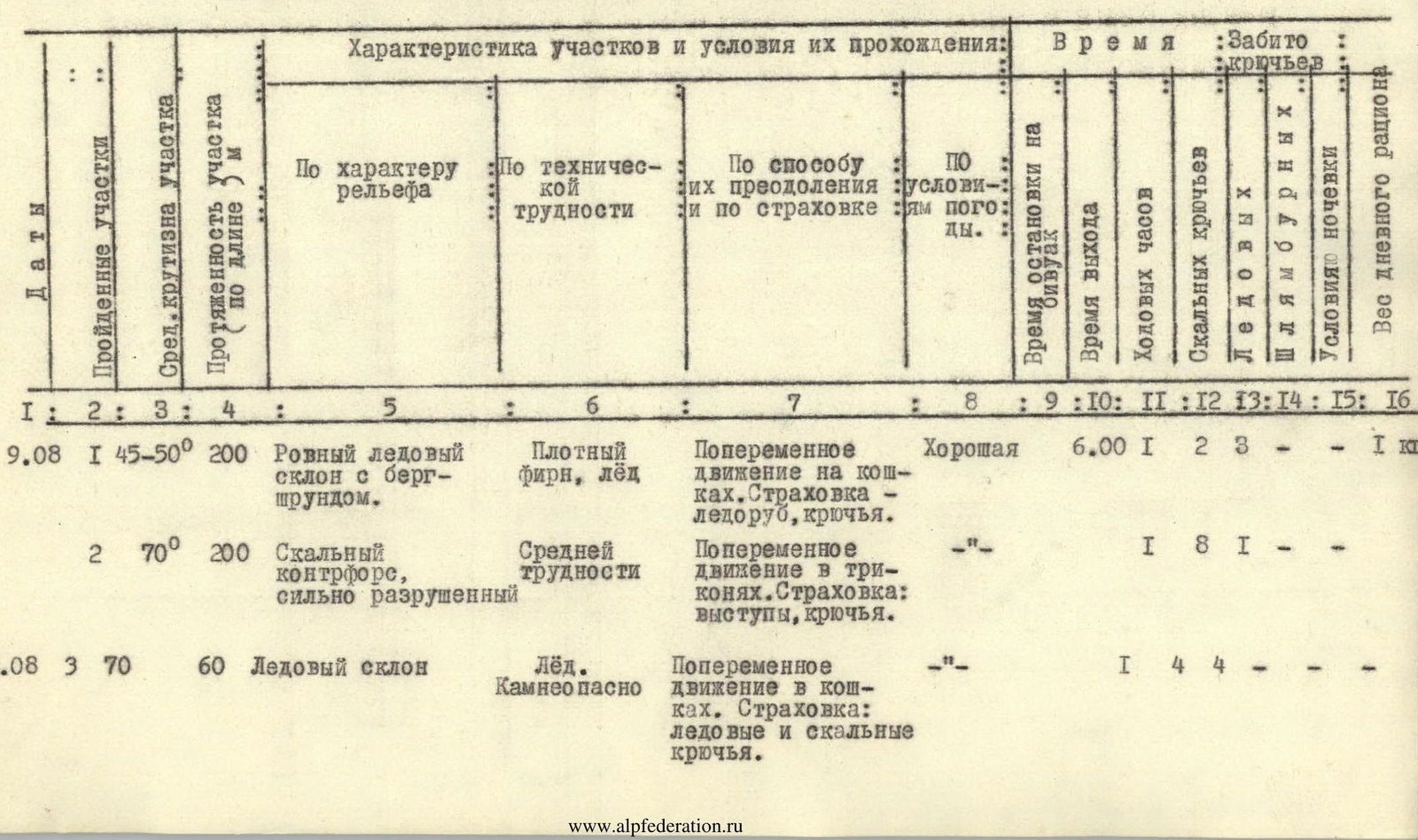
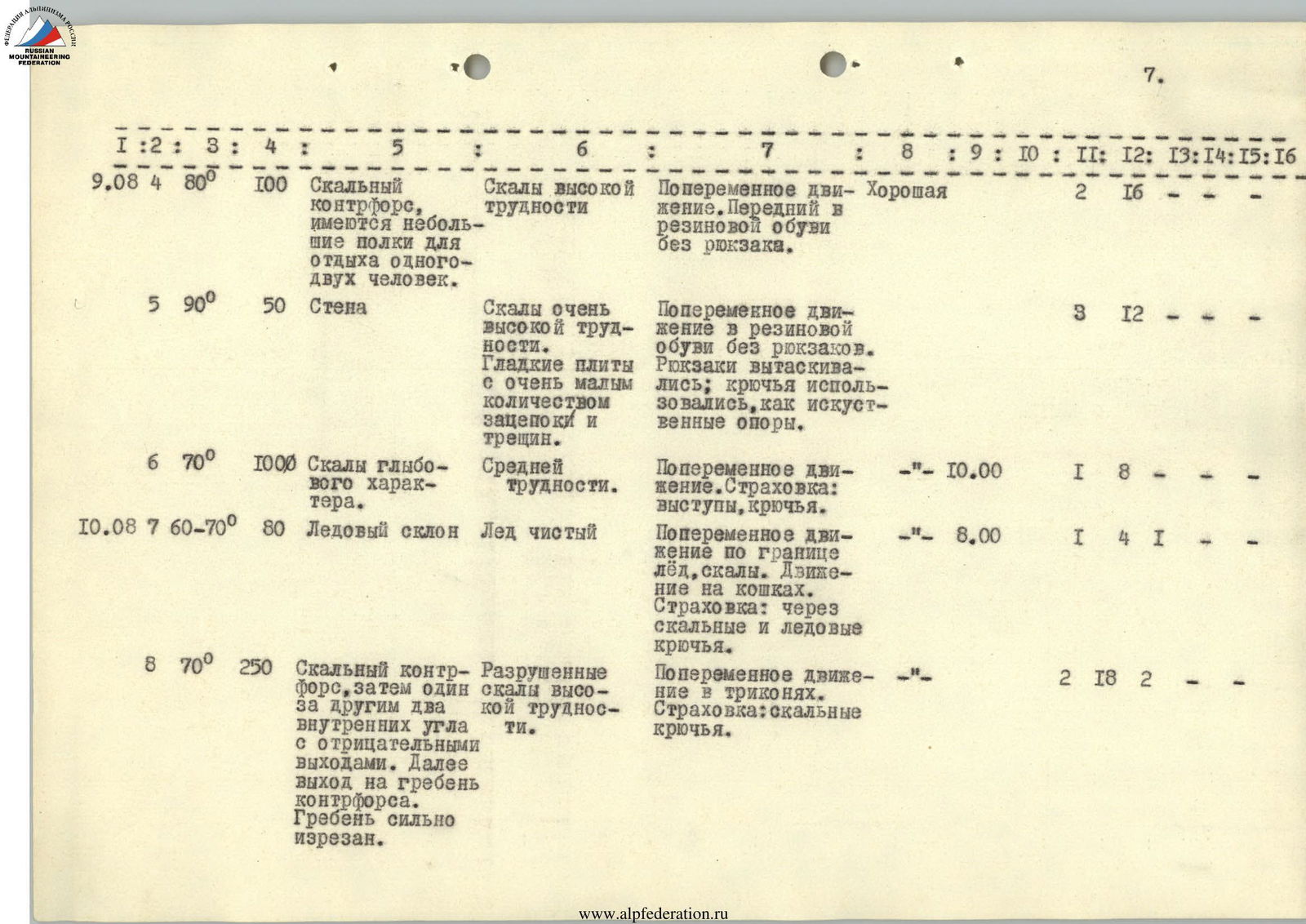
| Dates | Section | Steepness | Length, m | Character of terrain | Difficulty | Method of overcoming and protection | Weather | Time of exit | Working hours | Rock pitons | Ice screws | Shoulder pitons | Overnight conditions | Weight of daily ration | | :----- | :------ | :-------- | :-------- | :----------------------------------------------------------------------------------------- | :----------------------------------------- | :----------------------------------------------------------------------------------- | :$: | :---: | :----------- | :------------ | :----------- | :----------- | :-------------- | :--------------- | :------------------- | :-------------------- | | 9.08 | 1 | 45–50° | 200 | Flat ice slope with bergschrund | Firm snow, ice | Alternating movement in crampons. Protection: ice axe, screws | Good | 6:00 | 1 | 2 | 3 | — | — | 1 kg | | | 2 | 70° | 200 | Rock counterfort, heavily destroyed | Medium difficulty | Alternating movement in crampons. Protection: features, pitons | — | — | 8 | 1 | — | — | — | — | | 9.08 | 3 | 70° | 60 | Ice slope | Ice. Rockfall hazard | Alternating movement in crampons. Protection: ice and rock screws | — | — | 4 | 4 | — | — | — | — | | 9.08 | 4 | 80° | 100 | Rock counterfort, with small ledges for resting one or two people | High difficulty rocks | Alternating movement. First climber in rubber-soled shoes without a backpack | Good | — | 2 | 16 | — | — | — | — | | | 5 | 90° | 50 | Wall | Very high difficulty rocks. Smooth slabs | Alternating movement in rubber-soled shoes without backpacks. Pitons as artificial | — | — | 3 | 12 | — | — | — | — | | | | | | | with very few holds and cracks | holds | | | | | | | | | | | 6 | 70° | 100 | Boulder-like rocks | Medium difficulty | Alternating movement. Protection: features, pitons | — | 10:00 | 1 | 8 | — | — | — | — | | 10.08 | 7 | 60–70° | 80 | Ice slope | Clean ice | Alternating movement along the boundary of ice and rock. Crampons. Protection: rock | — | 8:00 | 1 | 4 | 1 | — | — | — | | | | | | | | and ice screws | | | | | | | | | | | 8 | 70° | 250 | Rock counterfort, then two internal corners with negative exits. Further exit onto the | Destroyed rocks of high difficulty | Alternating movement in crampons. Protection: rock pitons | — | — | 2 | 18 | 2 | — | — | — | | | | | | ridge of the counterfort. Ridge heavily serrated | | | | | | | | | | | | 11.08 | 9 | 85° | 40 | Wall with negative sections. At the base, a faintly visible ledge | Slabs of very high difficulty | Traverse under overhanging sections without backpacks in rubber-soled shoes. Pitons | Good | — | 2 | 6 | 1 | — | — | — | | | | | | | | used as additional support points | | | | | | | | | | | 10 | 85° | 60 | Wall, internal corner with overhanging sections | Slabs of very high difficulty | Ascent without backpacks. Pitons used as additional support points | — | — | 4 | 14 | — | — | — | — | | | 11 | 70° | 100 | Counterfort exiting onto the summit ridge | Steep rocks of high difficulty | Ascent with alternating protection via features and pitons | — | 7:00 PM | 1 | 3 | — | — | — | — | | 11.08 | 12 | 70° | 40 | Exit onto the ridge via the counterfort | Medium difficulty | Ascent with alternating protection via features | — | 8:00 | 0.5 | — | — | — | — | — | | | 13 | — | 120 | Ridge leading to the summit with gaps and "gendarmes" with a 20 m difference | Rocks of medium difficulty. "Gendarmes" | Simultaneous movement, protection via features | — | — | 1 | — | — | — | — | — | | | | | | | and gaps with a 20 m difference | | | | | | | | | |
The route to Skalnaya Stena peak from the north is more complex than routes such as:
- Central peak of Ullu-Tau from the north;
- Pik Purovskogo via "Surka";
- Pik Uzbekistan from the north-east.
The group assesses the routes to Skalnaya Stena peak from the north and west as 5B category routes.
Recommendations for the route
- The route to Skalnaya Stena peak is complex. It is difficult to find a place for a tent along the entire route. Therefore, the number of participants in the group should not exceed 4–6 people. Even for six people, it is challenging to gather in one place. It is best to have zip-off tents.
- The first half of the route is prone to rockfall. Therefore, it should be traversed early in the morning.
- It is necessary to have 40–50 rock pitons (horizontal and vertical), 5–8 ice screws, and 2–3 shovel pitons. Many pitons were required for the descent.
- The group did not bring sleeping bags, as the weather is stable at this time. They managed with down jackets.
- Provisions should be calculated for at least 3 days.
- Other routes to Skalnaya Stena peak include: a) Complete traverse of the ridge from west to east. Ascent via the wall from the Amshut glacier to the ridge and further along the ridge. b) Via the northern edge (it drops to the Kaznok glacier with ice walls). Exit to the ridge from the Amshut glacier via snow-ice ledges. v) Via the western wall from the "Dvoynoy" pass and further along the ridge to the summit.
All these routes are not below 5A category of complexity. Ascent leader and coach: S. Morozov
Comments
Sign in to leave a comment