Republican Climbing Club
Council of the Union of Sports Societies and Organizations
Kazakh SSR
Report
On the ascent of Peak Sugar Head (4971 m) via the northeast edge (Fann Mountains, Pamir-Alay) (First ascent)
Alma-Ata
1966 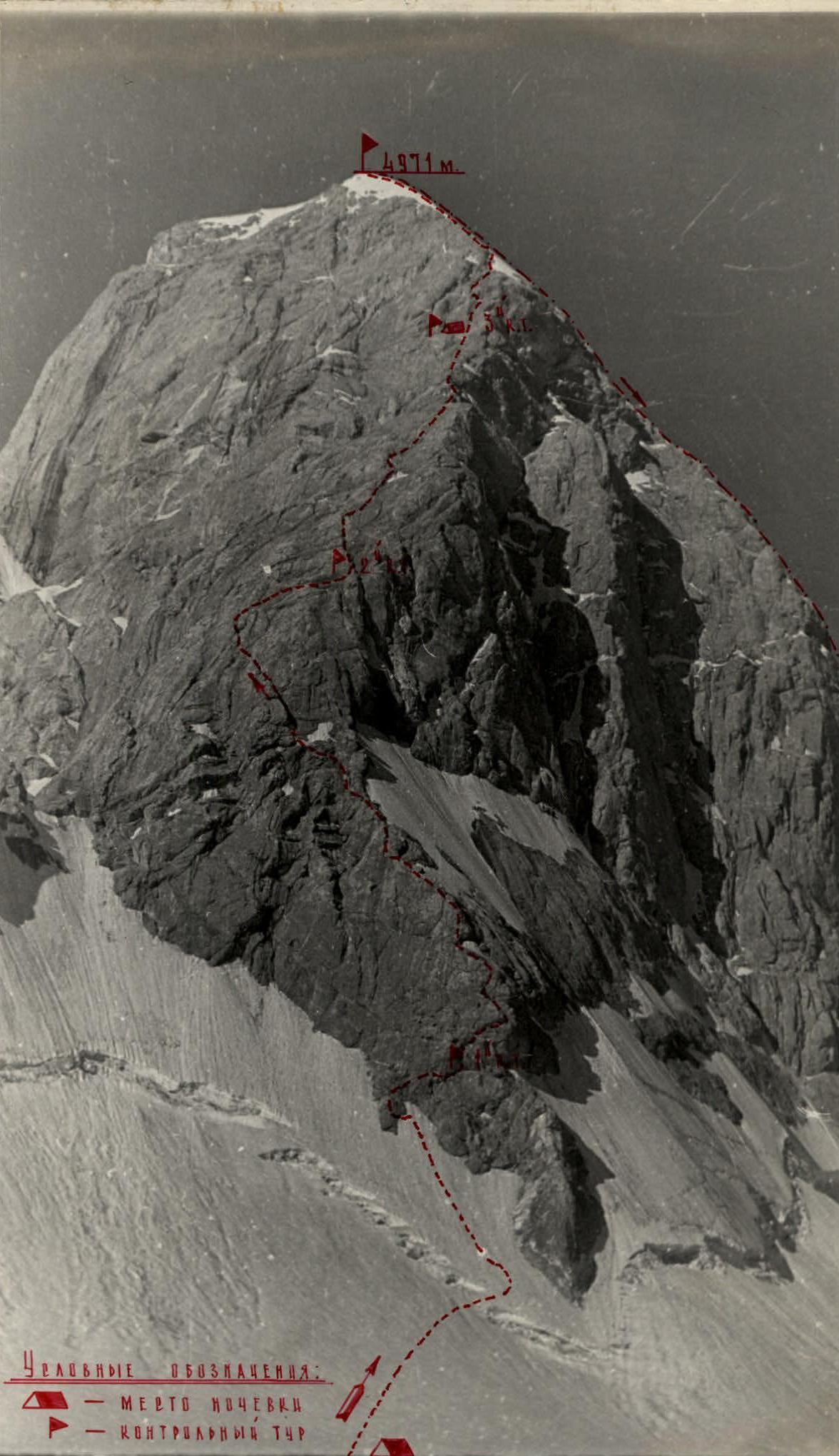
Photo #1
NORTHEAST EDGE
OF PEAK
SUGAR HEAD.
ASCENT ROUTE.
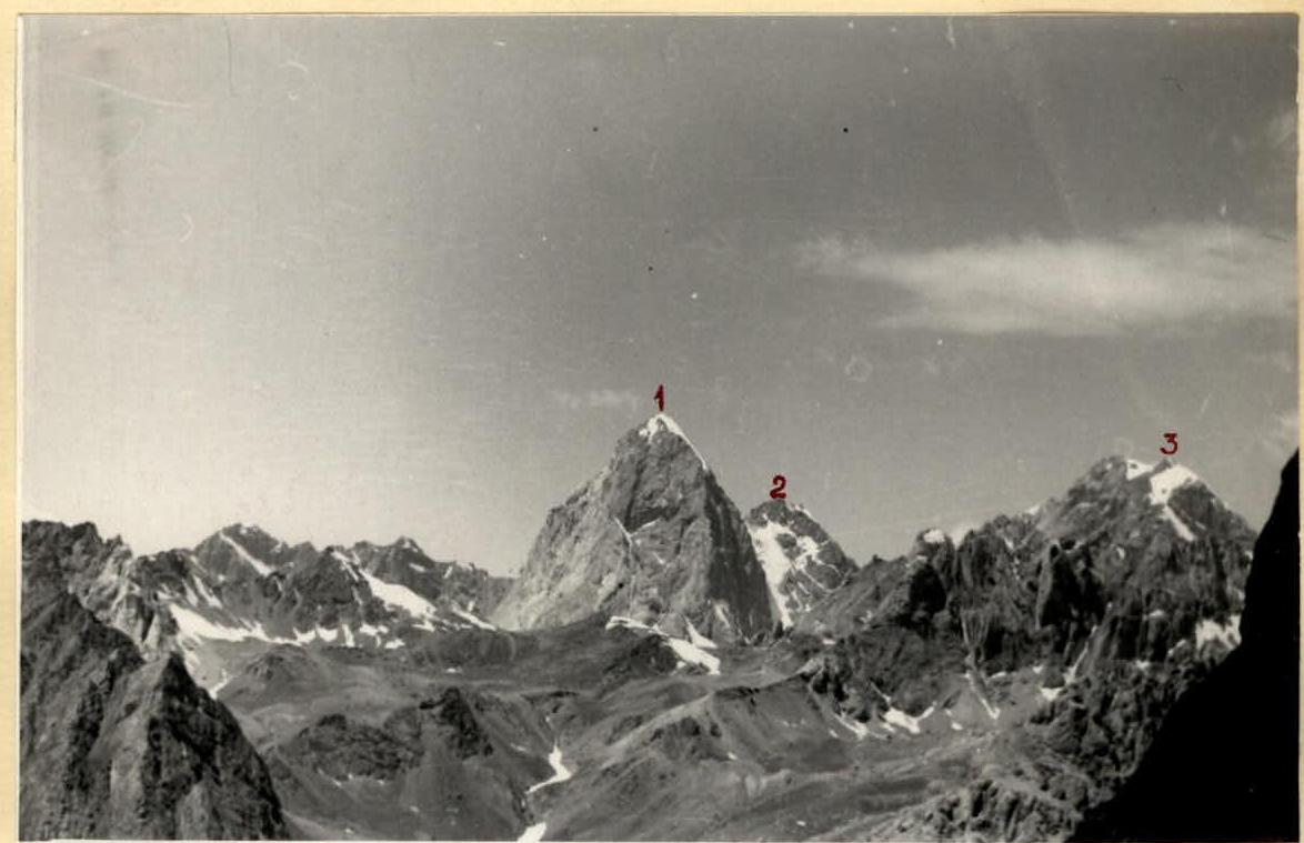
Photo #5
View of the southwestern group of peaks from the Kaznok pass.
- Sugar Head,
- Unnamed peak on the northwest ridge of Peak Sugar Head,
- Moscow.
The peak has the following ridges
- The northwestern ridge is narrow and steep, with a small destroyed peak in the middle. This ridge has been ascended, and the route is classified as category 5A.
- The southern ridge is rocky (leading towards the Pushnovat pass), very steep, composed of strong marble rocks. This ridge was first ascended by a group led by A.D. Terekhov (expedition of the Kazakh Climbing Club in 1966).
- Between the northwestern and southern ridges lies the southwestern sheer red wall with smooth negative walls. A route up this wall could be very challenging (requiring the use of piton hooks), but short (about 600 m).
- The second wall steeply drops into the Ahba-Say glacier cirque. It is less steep than the southwestern wall but significantly longer (about 1300 m). The wall begins with an ice-firn ramp with a large bergschrund at the top. The wall's considerable steepness (average 75–80%) deprives it of snow cover. The wall ends in a beautiful snow-ice dome (which is how the peak got its name from topographers), leading to the summit. The group ascended via the ridge and made a first ascent, rating the route as category 5B.
- The third wall, the southeastern one, is even more grandiose than the second, with a height difference of (1400–1600 m). It gives the peak a slender and beautiful appearance. It rises steeply from the glacier's foot. In the middle part of the wall, there are smooth slabs of great steepness. Obviously, these will be the key sections of the route. The wall is of great interest for a first ascent. Only a more serious task (participation in the USSR championship) prevented the group from ascending this wall.
The massif of Peak Sugar Head is composed of marble (southwestern wall), sandstone, and limestone (northern and southeastern walls).
Photo #7
View of Sugar Head from Peak Moscow.
— classified route, category 5A 
Photo #8
Southeastern wall of Peak Sugar Head. The profile of the northern wall is visible on the right.
These rocks, as is known, when destroyed, form particularly grandiose walls.
7. Approaches to the Ahba-Soy glacier area
On July 28, 1966, the group arrived at the Ahba-Soy gorge. The group faced the following tasks:
- a) conduct a training ascent,
- b) complete an ascent for the championship of the Kazakh SSR in mountaineering (with Peak Sugar Head or Moscow as targets),
- c) survey objects for ascents planned for the 1966 USSR mountaineering championship.
From the base camp, the group departed at 16:00, expecting to reach the Ahba-Soy glacier in 2–3 hours. The journey was hot, with no clouds in the sky. The path followed a trail along the Ahba-Soy riverbank; the gorge was fairly gentle. To the left, the walls of Peak Arg loomed menacingly. Initially, they shed excess clothing, but soon regretted it: the path was frequently crossed by branches of the poisonous yugan plant, requiring caution. The surroundings were picturesque, especially where water dominated. Birches and willows were found along the riverbank, and lush archa spread across the slopes. Except for Makhanov V. and Postnova N., everyone was there for the first time. We were eager to see our targets. Finally, after a significant ascent, we saw the upper part of Sugar Head. It was indeed a "sugar head": the summit rocks were crowned with a beautiful snow dome.
With renewed energy, we reached the alpine meadow zone. Our arrival caused discontent among the dogs guarding the flock. The entire gorge was visible, with Sugar Head blocking it; we now saw it from the foot to the summit. To the right, behind Sugar Head, Peak Moscow was visible, looking less impressive.
We set up camp under the Ahba-Soy glacier; aside from firewood, all amenities were available.
July 29 was planned for a training ascent.
8. Organization and tactical plan for the ascent
On July 29, early in the morning, the group departed from the intermediate camp and ascended the steep moraine to the Ahba-Soy glacier. From the glacier, both planned targets were visible. A more or less challenging ascent could be made:
- up the northern wall of Peak Sugar Head,
- up the southeastern wall of Peak Moscow.
An ascent up the southeastern wall of Sugar Head was immediately ruled out due to its perceived difficulty and the significant effort it would require. The group could not risk the main event of the expedition. Four team members (Melnikov V., Makhanov V., Sedelnikov V., Yuzhanov Yu.) were to ascend to the championship of the Kazakh SSR and then proceed to штурм (assault) Peak Chandara for the USSR mountaineering championship in the high-altitude, technically complex class.
Both walls were roughly equal in length, but the northern wall's average steepness was greater. The difficulty in ascending the southeastern wall was mainly in its lower part (350–400 m); the upper part transitioned into gentle, destroyed rocks. Conversely, the difficulties on the northern wall increased with altitude. The key sections (smooth slabs) were in the middle of the route, and the wall ended in a steep ice-firn dome. On the northern wall, the group was exposed to the sun, making the ascent more challenging due to potential sections of surface hoarfrost.
The northern wall of Sugar Head appeared significantly more menacing and complex than the southeastern wall of Peak Moscow. Upon final review and comparison of the routes, preference was given to the northern wall as more challenging (secretly, we had dreamed of it since Alma-Ata). The path to the summit was visible via the northeast ridge on the left side of the wall. Based on this, the training ascent route was determined:
- Ascend Peak Moscow via a simpler route,
- From the summit, clarify the route in the upper part of the northern wall.
- Additionally, from Moscow, we could examine Peak Scalnyaya Stena, an ascent planned for the USSR championship.
The most suitable path to Peak Moscow was the southeastern ridge, which was ascended on the same day. The ridge was ascended for the first time and rated as a category 4B route.
The group members felt good during the training ascent.
The doctor summarized observations during the ascent and in the intermediate camp and gave the "go-ahead" for the ascent. The ascent was scheduled for August 1.
On July 30, the group conducted another training ascent, this time to Sugar Head via the classified category 4B route (northwestern ridge). From this route, the path along the ice-firn dome and the upper part of the northern wall was carefully examined.
When compiling the tactical plan for the ascent via the northeast ridge of Peak Sugar Head, the group considered both practical experience and the results of training ascents. It was clear that for the first climber, overcoming the most difficult sections of the ridge would be possible only in crampons and without a backpack. Other participants would have to ascend using the first climber's rope. Backpacks on challenging sections would need to be lifted by rope.
This method of group movement naturally required a lot of time, so a speedy variant was dismissed.
General ascent scheme:
The assault group would leave the intermediate camp early in the morning, reach the Ahba-Soy glacier, and process part of the route on the same day. The next 3–4 days would be spent ascending the northeast ridge and descending via the northwest ridge.
Due to the ridge's significant steepness, hanging night bivouacs were possible.
Maximum relief for the group:
- High-calorie, lightweight food,
- Specialized equipment.
Signaling with flares according to a pre-compiled schedule. An observation group would ascend to upper bivouacs (on the glacier) on the day after the assault group processed the route and observe the assault group from there.
Communication with the base camp via a messenger.
9. Route description
After completing preparations in the intermediate camp, the assault schedule was finalized:
July 31 — rest day. August 1 — move to upper bivouacs and process the route. August 2–4 — ascend the northeast ridge and descend via the northwest ridge.
Return deadline to the base camp — August 5. The group departed from the intermediate camp at 5:00. In the pre-dawn darkness, they traversed the glacier's moraine and stopped at the upper bivouacs to rest. The weather was excellent. After a brief discussion, they decided:
- A four-person team without backpacks would process the route.
- The remaining pair would prepare lunch and finalize the equipment selection for the assault.
At 8:00, Sedelnikov V., Melnikov V., Gisantulin M., and Golodov Yu. began processing the route. We moved across the glacier towards the "shoe" descending from a not clearly defined counterfort. The glacier was riddled with many crevices, so we had to rope up.
Section R1. We approached the ice-firn ascent, intersected by a wide bergschrund. Securing ourselves with ice axes, we approached the bergschrund, which we crossed via a snow bridge, securing with ice screws.
Section R2. The ice-firn slope was up to 60° steep. We moved with insurance via screw hooks, bypassing the "shoe" on the left. The section ended in clean ice; we cut steps to approach a rocky outcrop. Along it, we ascended 10 m of medium-difficulty rocks and reached a platform where we could change shoes. Further, we encountered dry rocks, allowing us to wear crampons and sneakers. We left 100 m of rappel rope for descent on the ice section.
Section R3. Immediately after the platform, there was a 1.5 m wall; we ascended with a boost. Ahead lay slabs up to 60° with strong holds. The slabs ended in a small niche where we left the 1st control cairn. From the cairn, a faintly visible ledge led upward to the right, ending in a sheer wall towards the glacier. We moved, securing ourselves with rock pitons.
Section R4. The ledge led to a smoothed slab without holds, about 20 m long. Overcoming this slab in boots would have been very challenging. In crampons, the slab was traversed on friction; the nodule surface of the rocks provided good grip. The slab led to rocks resembling "ram's foreheads," about 100 m of medium-difficulty climbing, with an exit onto the "shoe's" crest. Ahead lay a smooth slab about 20 m long. After careful insurance, we passed it and reached a not clearly defined black internal corner with a ledge; to the left, large blocks broke off the wall.
Section R5. From the internal corner, via rocks resembling "ram's foreheads" without holds, securing with a titanium channel piton, the first climber reached under a rock overhang of rusty color. The overhang was bypassed to the right and upward (15 m, 80°) via a faintly visible crack using 3-step ladders. For those following, a 10-step ladder was hung. To the left of the overhang, there were dangerous "rock mines." Further, via medium-difficulty rocks, we exited sharply left onto a rock ledge with a small descent (about 3 m) onto a large smooth inclined shelf. Below us lay the wall; we saw the start of our route and the "shoe," which no longer seemed like a "shoe" from here.
The sun was now shining. We were hungry, and our ropes had run out. Using the laid perches, we descended, leaving the "forge" for the last section. Each perch rope was secured to 2 reliable pitons.
At the bivouac, the remaining pair treated the "processors" to a long-stale lunch — we hadn't planned to be so delayed.
The wall proved to be a tough nut, especially the last section. In the evening, a small meeting in the tent concluded:
- The group had underestimated the route; it was more challenging than expected but passable.
- For greater clarity and reliability in work on the ridge, additional pitons were needed.
- For bivouacs on the route, "zdarki" (portable sleeping bags) were necessary due to possible sitting bivouacs.
August 2. Early departure; with the first sun rays, we were on the ridge. We put on crampons and sneakers again on the rocky outcrop, hiding our boots in backpacks, which immediately felt heavier. We ascended at a good pace along the laid perches. In two places, we had to pull up our backpacks. By around 10:00, we were on the inclined shelf. Ahead lay a challenging psychological section (the shelf ended in a sheer wall).
Section R6. The group entrusted the most youthful member, Yura Golodov, to pass this section — let him get battle-hardened in the struggle with the mountains. Along the boundary of surface hoarfrost and rocks, Yura reached an inclined smoothed slab (75°) without holds, using ladders in some places, and then reached surface hoarfrost. Further, via a narrow wet rocky outcrop with screw and rock pitons for insurance, he reached a shelf, where the rest followed via perches and a thrown 10-step ladder. Even with perches, it was difficult to climb. We pulled up our backpacks. Well done, Yura! He passed this section well.
Section R7. Via medium-difficulty rocks with individual slabs, we ascended 80 m. Water flowed over the slabs; we tried not to wet our crampons. We exited onto an inclined shelf.
Section R8. Along the inclined shelf to the left and upward, we reached under a slab; the insurance point was in a niche under the slab. We bypassed the slab via a V-shaped couloir to the left and upward with piton insurance. Further, 50 m steeply upward to an inclined shelf and along it to a detached stone. From the stone, a wide shelf, littered with stones, led (be careful — the shelf ends in a sheer wall). The end of this shelf led onto a crest leading to the ice dome; we needed to follow it. To the right, a smooth wall with large internal corners dropped sheerly to the glacier.
We felt somewhat encouraged upon seeing the ice dome; the summit was somewhere beyond it. We examined Peak Moscow and its southeastern wall; the upper part was indeed easy, as observed from the glacier. There was a possible bivouac on the shelf.
Rare clouds drifted in. We snacked, smoked, left the 2nd control cairn, and continued.
Section R9. From the cairn upward along a 70° wall, 20 m without holds (climbed on friction), we exited onto medium-difficulty rocks and ascended 120 m to the ridge under a red rock on the ridge. Near the rock, there was a small platform with a snow cornice hanging to the right. The section was traversed with insurance via wooden wedges and ice pitons driven into rocks.
Section R10. The path along the ridge was impossible; we had to exit back onto the wall. With careful insurance, we traversed a slab devoid of holds and cracks; piton hooks and ladders were used. Very difficult climbing. Finally, this section was passed; we reached a small ledge with a niche (good insurance point). We pulled up our backpacks.
It was late; we felt we wouldn't reach the summit that day, especially as we were enveloped in clouds, and visibility worsened. We decided to bivouac on this ledge.
The bivouac, though sitting, was comfortable. We leveled the ledge, attached "zdarki," and prepared food. The "Febus" stove worked well; our mood was excellent — we had passed a significant part of the ridge, and the ice dome was nearby. Tomorrow, we should reach the summit. In the evening, the fog cleared, and we saw a light in the tent on the glacier; our observers were waiting for a signal. A green flare soared into the sky...
August 3. We left the 3rd control cairn in the niche. Departure at 7:00.
Section R11. From the 3rd control cairn, 100 m upward via medium and complex rocks, adhering to the crest. Exit onto a good shelf.
Section R12. From the shelf, exit under a negative angle 4–5 m, insurance via rock pitons, mainly petal-shaped. The angle was traversed on friction. From the negative angle, we exited back onto the crest. Insurance point, a platform for 2 people.
Section R13. Along the crest, 140 m, we ascended via medium-difficulty rocks to a large platform where a bivouac was possible.
Section R14. Along a very narrow ledge with surface hoarfrost and small gravel, we exited under a negative angle filled with surface hoarfrost (3 pitons). From under the angle, we continued left and exited onto "ram's foreheads," then 10–15 m to an inclined groove (50 m). The groove led onto the crest, to the boundary of ice and rocks. We put on crampons; further ascent in sneakers was impossible.
Section R15. Further movement was along the boundary of ice and rocks, exiting into an ice couloir, 45–50°, which was traversed with insurance via screw pitons. With step-cutting, we exited onto a dome-shaped platform. It was very difficult to find cracks for driving pitons. Shingled rocks flaked off when driving pitons.
Section R16. The next 60 m were traversed via shingled rocks; very difficult climbing in boots (we had grown accustomed to crampons). Exit to a 1.5–2 m wall, where insurance could be organized. Everyone gathered. We were now at the ice dome, towards which we had strived so eagerly. Beyond it lay the summit. The day was ending. The dome was effectively highlighted by the evening sun.
Section R17. The snow layer on the dome was thin. To ease our burden, we hadn't taken crampons. We had to cut steps. With step-cutting, we traversed about 100 m.
We insured ourselves with screw pitons. On the last 80 m, the snow became deeper; we switched to insurance via an ice axe. We reached a large snow platform — the highest point. To the side, 5 m away, on the rocks, was a cairn.
Before us lay the evening panorama of the Fann Mountains. We were tired but glad to have emerged victorious in our duel with nature once again.
We replaced the note and hurried to begin our descent. The descent followed the classified category 4B route, familiar from our previous ascent, so we descended quickly. Already in the twilight, we reached the saddle between Sugar Head and the unnamed peak on the northwestern ridge, where the category 4B route begins. Here, there were ready-made platforms for bivouacs. We conducted a communication session and climbed into "zdarki."
August 4. The sun found us still in our sleeping bags. Warming up under its rays, we packed our gear, and within 2 hours, we were back at the camp under the Ahba-Soy glacier, where we were met by observers. We congratulated each other on our victory.
Conclusions
- Group members, having experience in ascents via various routes in Central Tian Shan, Pamir, Trans-Ili Alatau, Kyrgyz Alatau, and the Caucasus, considered the route up the northern wall of Peak Sugar Head to meet the requirements of category 5B.
- During the ascent, new equipment samples were finally tested, proving to be excellent, especially screw ice pitons. The equipment was tested under various tactical combinations during a challenging ascent. During the ascent of Peak Chapdara (for the USSR championship), the equipment tested on Sugar Head was primarily used.
- During ascents in the Ahba-Soy glacier area, especially on the northeast ridge of Sugar Head, participants preparing for the assault on Peak Chandara (entered for the USSR championship in the high-altitude, technically complex class) received good training and coordination, testing various tactical options while passing route sections. Other participants significantly improved their technical and tactical skills.
- The tasks set before the group upon departure to the Ahba-Soy glacier area were accomplished.
Table of basic technical characteristics of the ascent route up the northern wall of Peak Sugar Head — 4971 m
Height range (maximum) — 1200 m. Average steepness — 70°.
Number of pitons:
- Rock — 140 pcs.
- Ice — 4 pcs.
- Screw — 25 pcs.
- Piton hooks — 4 pcs.
Climbing on ladders — 39 m.
| Section # | Height gain, m | Section length, m | Average steepness, ° | Brief terrain characteristics | Section and passage conditions characteristics | Piton usage | Time, h |
|---|---|---|---|---|---|---|---|
| Day one | |||||||
| R1 | 80 | 150 | 30 | Ice-firn ascent | medium difficulty | 3 screw | 8:00–17:00, 9 |
| R2 | 60 | 100 | 50–60 | Ice-firn slope with bergschrund. Rocky outcrop | medium difficulty | 1 screw, 6 screw | |
| R3 | 40 | 80 | 60 | 1.5 m wall, 90°. Slab with strong holds. Rocky shelf | medium difficulty, difficult | 10 | |
| R4 | 120 | 140 | 70 | Smoothed slabs without holds, then "ram's foreheads" and again smooth slabs | difficult | 26 | |
| R5 | 40 | 60 | 70–80 | Rocks like "ram's foreheads," faint crack to bypass rock overhang | very difficult | 20, 8 | |
| Descent to upper bivouacs on the glacier | Bivouac in a tent, on the glacier | 8:00–17:00, 57, 9, 8 m | |||||
| Total for the first day: 340 m | |||||||
| Second day | |||||||
| Passage of sections R1–R5. Backpacks pulled up on sections R4, R5. | |||||||
| R6 | 100 | 120 | 75 | Inclined slab with surface hoarfrost, ice groove with narrow rocky outcrop | very difficult | 5 screw, 60 m | 5:30–18:00, 12:00, 18 |
| R7 | 50 | 60 | 40–50 | Rocks of medium difficulty with individual slabs | medium difficulty | 6 | |
| R8 | 100 | 170 | 40–50 | Inclined shelf, smooth slabs, inclined shelf | medium difficulty | 10 | |
| R9 | 140 | 150 | 60–70 | 70° wall without holds, especially difficult in the lower part, then medium-difficulty rocks with few cracks | difficult, medium difficulty | 8 rock, 5 wooden wedges, 3 | |
| R10 | 50 | 60 | 70–80 | Slab without cracks and holds | very difficult | 10 rock, 4 piton hooks, 6 x 50 m, 15 | |
| Total for the second day: 440 m | Sitting bivouac on a narrow ledge under rock protection. | 43, 8 | 6 x 110 m, 25 | ||||
| Third day | |||||||
| August 3, 1966 | R11 | 60 | 100 | 50 | Rocks of medium difficulty, sections of complex rocks | medium and difficult | 700, 21:00, 13, 10 |
| R12 | 60 | 60 | 60 | Negative angle | very difficult and medium difficulty | 7 | 1 x 60 m, 4 m |
| R13 | 110 | 140 | 50–60 | Ridge with rocks of medium difficulty | medium difficulty | 8 | |
| R14 | 60 | 60 | 60 | Narrow ledge filled with surface hoarfrost, transitioning into a negative angle filled with surface hoarfrost. Then "ram's foreheads," transitioning into a groove | difficult | 10 | 1 x 60 m, 2 m |
| R15 | 50 | 60 | 45–50 | Ice couloir leading to a dome-shaped platform | difficult | 4 screw | |
| R16 | 50 | 60 | 50 | Shingled rocks with slabs | difficult | 4 | |
| R17 | 100 | 180 | 40–50 | Ice-firn dome | medium difficulty | 9 (including 8 screw) | |
| Descent via the classified category 4B route to the peak on the northwestern ridge | Bivouac on platforms, lying in "zdarkekhs," classified route, saddle between Sugar Head and the peak on the northwestern ridge. | 44, 12 | 2 x 60 m, 6 m | ||||
| Total for the third day: 490 m | |||||||
| August 4, 1966 | Descent to bivouacs under the Ahba-Soy glacier, bypassing the southwestern wall, and return to the base camp. |
Description compiled by: V. Sedelnikov March 23, 1966