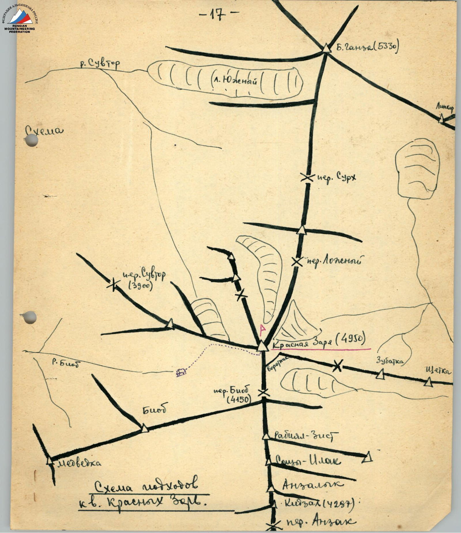
Description of the ascent to the peak Krasnykh Zory (from the south, approximately)
Peak Krasnykh Zory (4950 m) is located in the Fann Mountains in the upper reaches of the Biiob river, in a spur extending in a southwest direction from the peak Bolshaya Ganza.
The peak is rocky, almost without snow cover; ice is found in chimneys facing north. The rocks are heavily destroyed but have few cracks for driving in rock pitons. In the cracks, wedges are well used for belays.
The first ascent to this peak was made "to Krasnye Zori" in 1937 by the Rigzel-Kavakova group from the north. In the note left by the pioneers, it is indicated that they consider it as a 3B category of difficulty route.
We undertook an ascent from the south along the ridge. Approaches to the peak from Lake Iskander-Kul: up the Sarytog river, then along the Arg river, and then along the Biiob river to its upper reaches. It is better to spend the night before the pass, where there is water, firewood, and no wind.
From the overnight site, we ascend along the dry riverbed through the moraine to the western ridge along easy but heavily destroyed rocks. We reach the southern ridge, bypassing several easy gendarmes on the right and left. The ascent to the southern ridge from the overnight site takes 3-4 hours. A note lies at the beginning of the route.
The route can be divided into three sections:
- from the start of the route to the first col;
- from the first to the second col;
- from the second col to the summit.
The path to the first col is initially up an indistinct chimney to a plug (1 rock piton). We pass the plug "head-on" through a narrow gap between rocks. We bypass a small gendarme on the right and then go vertically up (25 m) through a wide gap (3 rock pitons) and exit along the ridge to large rocks. We bypass the rocks on the right from below and along a wide chute with a crack at the bottom (45 m), which is filled with rocks from above. At the top, to the left of the rocks, we exit onto a very narrow ridge and along it to a very destroyed second gendarme, which is overcome "head-on". We descend from the gendarme to the first col (4630 m).
After it, the ascent is vertically up 20 m along a wide crack with piton belays and to the left of the wall of the third gendarme along a small recess. The ascent to the ridge is visible through a jumble of rocks. The ridge is very sharp; along it for 15 m and then left along an inclined crack on the slabs (2 pitons) 10 m up and to the right, and 7 m up a sheer face (2 pitons).
Further:
- a heavily destroyed rocky section to the left of the ridge. Having overcome it, we approach the fourth gendarme.
- the gendarme is bypassed on the right through a 10-meter chimney with a steepness of 75–80° with ice (3 pitons).
- beyond the gendarme is the second col.
Beyond the second col, to bypass a very large rock on the right, we lose 15 m in height and ascend along a snowy-icy couloir 20 m long. We continue to move to the right of the ridge. The rocks are of medium difficulty. Belays are through ledges. We exit onto a small snowy slope and from it to the summit. The summit is a rocky area protruding 2 m above the snowy ridge. To the north of it, a ledge is visible 50 m below it. We were on the summit for 10 minutes. Throughout the ascent, there was a dusty haze, and the view from the summit was very poor. It is for this reason that we do not have a single photograph of the route sections.
The ascent was made on July 29, 1962, by a sports group consisting of:
- G.L. Gulnev — 1st sports category, leader;
- V.G. Mironenko — 2nd sports category, participant.
The group was released on the route according to the route sheet of the Varzob alpine camp. The ascent was continuously monitored by a support group.
The time required to complete the ascent from the start of the route to the summit is 7-8 hours. 11 rock pitons were driven on the route. Descent is by the ascent route.
We believe that the ascent should be classified as not less than 3B category of difficulty.
 The path of ascent to the peak Krasnykh Zory along the southern ridge. (Photo from the summit of Biiob)