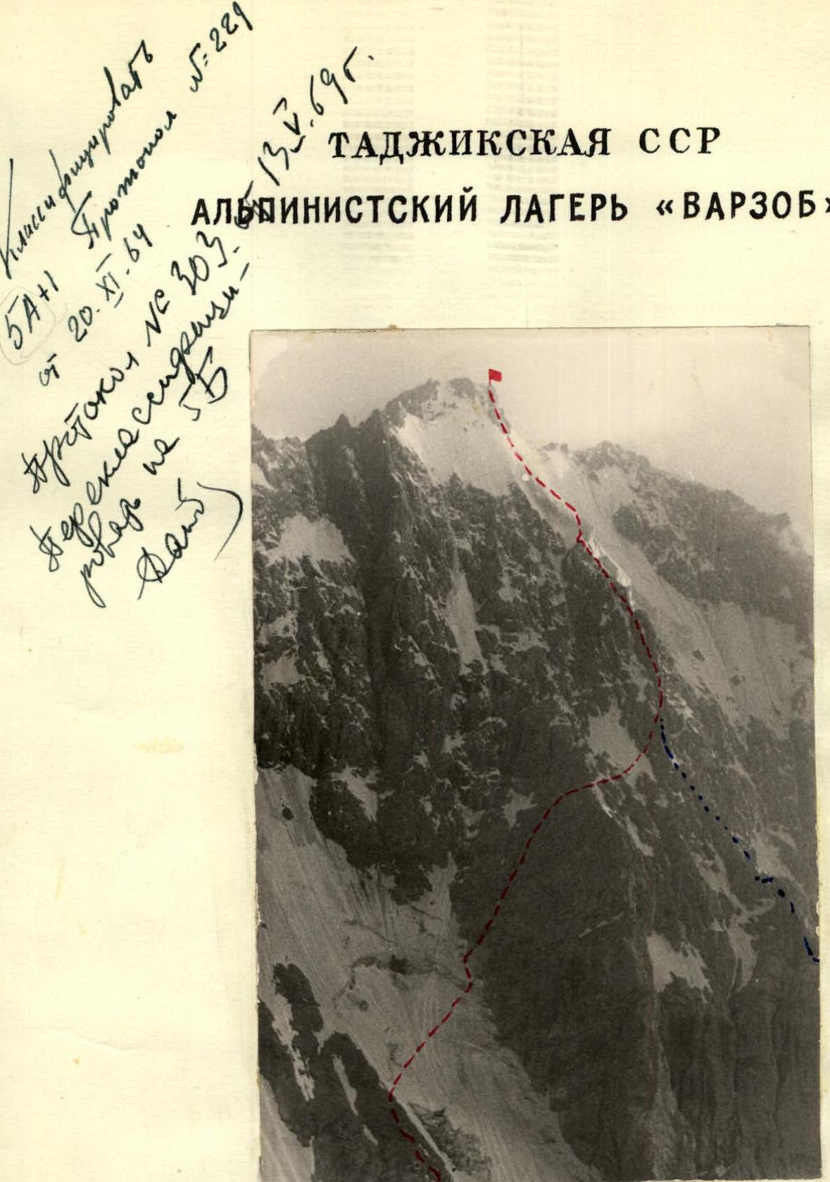
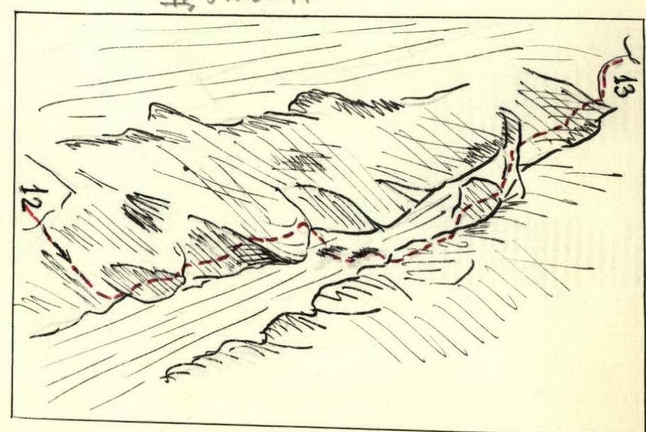
Dukdon — Central Peak, category 5B difficulty
Route Map
Description of the Ascent to Dukdon Peak, category 5B difficulty
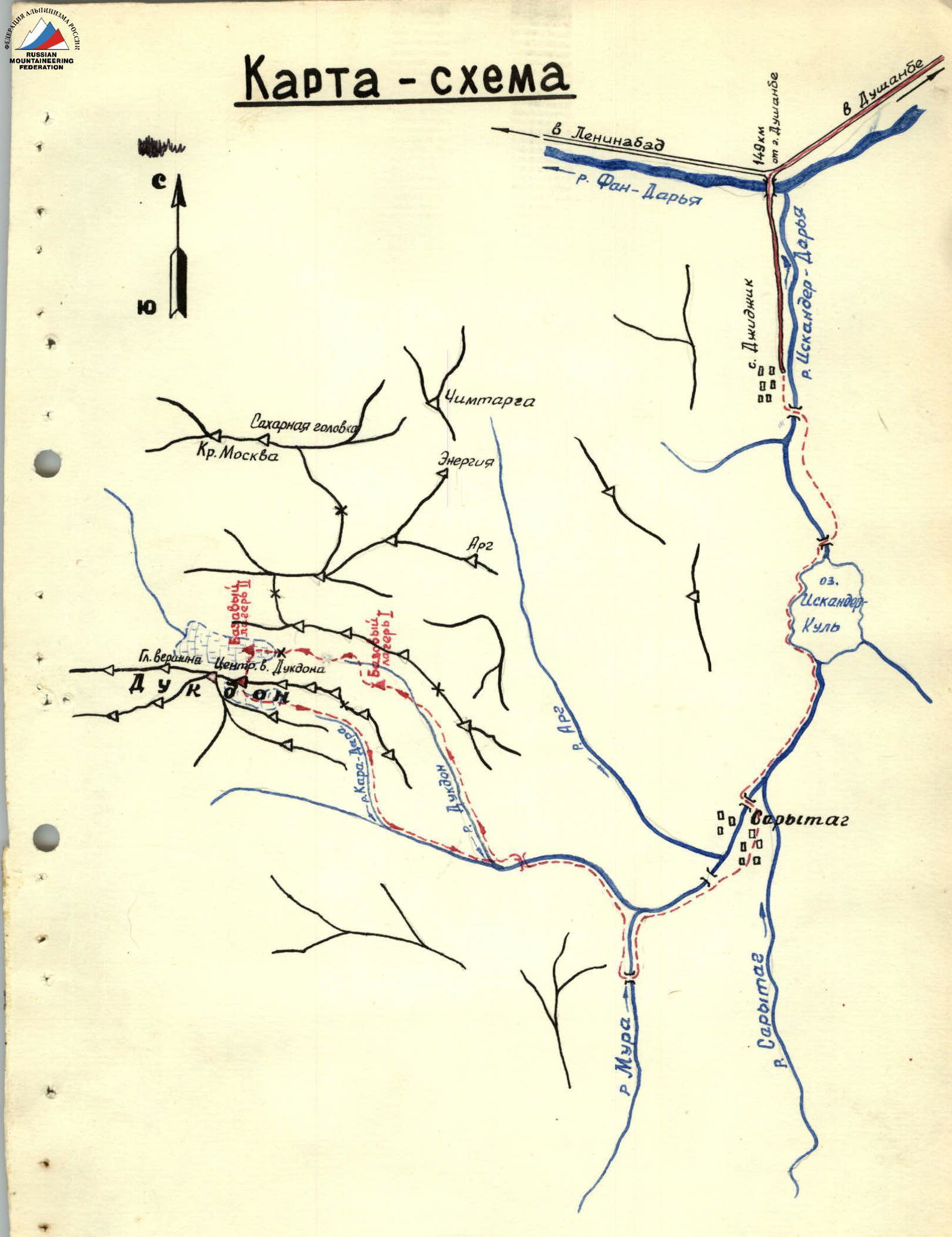
The Dukdon peak, with an elevation of 5200 m, is located in the Fann Mountains of the Pamiro-Alay region. The Fann Mountains are characterized by fault-block structures without pronounced foldings. The main Zeravshan ridge lies aside. The Dukdon massif stretches approximately 15 km in a latitudinal direction and includes several peaks above 5000 m.
The group targeted the central peak from which a southern spur branches off, transitioning into a parallel ridge.
The approach to Dukdon begins from the village of Dji-Djik, where the motorable road ends. The route continues:
- Along the Iskander-Darya River (3 hours).
- Around Iskander-Kul Lake (1 hour).
- Along the Sary-Tag River to the Sary-Tag village (2 hours).
- Along the Kara-Kul River to its confluence with the Dukdon River (4 hours).
- Up the Dukdon River towards the Dukdon Pass and 350 m below it (4 hours).
Preliminary reconnaissance allowed the group to identify a potential descent route to the south. As later confirmed, this was the only feasible descent route. Descending from the Dukdon massif elsewhere is either impossible or very challenging due to steep, smoothed walls and cliffs, some of which are dissected by waterfalls.
The base camp was set up on the medial moraine of the glacier descending from the Dukdon Pass to the west.
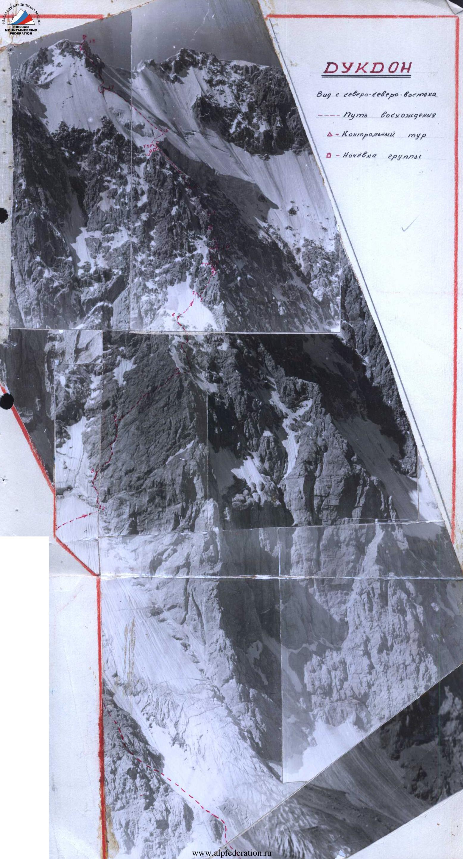
We proceed along the moraine, then on ice and snow, towards a broad couloir divided by a large rock outcrop stretching from top to bottom. The rocks are heavily weathered, with scree on the ledges. We ascend along this outcrop almost to its top (250–270 m) under the bergschrund on the right side of the couloir.
In crampons, we traverse the snow-ice slope under the bergschrund (R2) towards the wall. About 10 m from the rocks, we descend into the bergschrund, then ascend via a protruding grey rock, which is very smoothed, about 6–8 m high. Protection is provided by ice screws.
The climbing is very difficult because removing crampons is not feasible due to the presence of rimaye ice. We enter the upper edge of the bergschrund, then:
- Right onto a ridge of ice and rocks;
- Then along the angle formed by rocks and ice.
Difficult climbing leads to a sharp, steep snow ridge formed between rocks and snow (10 m). We traverse left onto a small wall, which is climbed via a crack on the left.
The section from the bergschrund to the wall is 120 m (R3). Protection is via pitons. It is advisable to climb this section early in the morning to avoid rockfall.
We continue straight to wet rocks with black spots, which are bypassed on the left. Above them, a couloir with rimaye ice terminates, with an exit on the right side. The couloir is prone to rockfall. After ascending 40–50 m, we move slightly right onto red rocks emerging in the ridge.
The section (R4) is 280 m long. The rocks are of moderate difficulty with holds, all smoothed; protection is exclusively via pitons. On the entire wall, belay points should be chosen under overhangs; rocks fall from the left from a red pillar and sweep the entire wall. Helmets are recommended. Due to this, the group had to move rightward along a smoothed, steep ledge protected by an overhang.
On this section, the following were used:
- 6 wedges
- Wide cracks
- 19 rock pitons
Between August 17 and 19, 1953, the group observed the route and prepared it up to the wet couloir, gaining a certain time advantage.
We reach the red rocks (which are crumbly with many loose stones) and ascend via a steep groove with vertical sections, using friction and jamming. The first climber goes without a backpack. We reach a snow patch on the wall. This section (R5) is 300 m long. Again, careful piton protection is used.
On the snowfield, there are outcrops of weathered rocks with scree (R6). We ascend these (120–130 m) to the highest rock (3 m high) on the snowfield, where there is a convenient, scree-covered ledge that can accommodate four people.
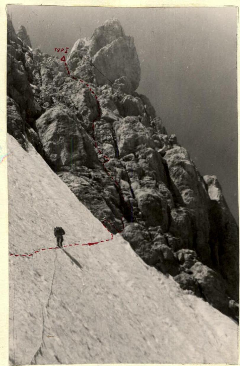
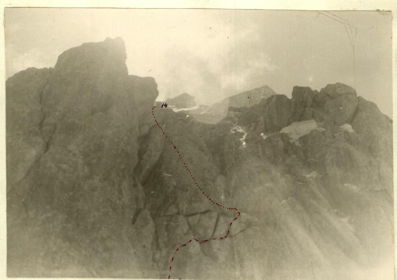
We traverse the snow patch (R7) almost horizontally towards a distinctive pillar resembling a finger, approached via a vertical cleft. (See photo). This snow-ice section is traversed in crampons, about 100 m long, with a gradient of approximately 50°; careful protection is provided by ice screws, and step-cutting is necessary. A piton can be placed in the rock. At the base of the wall with the cleft, we remove our crampons. The ledge is small, accommodating only two people, but 20 m to the right of the cleft, there is a larger ledge. The cleft (which turns into a narrow couloir at its upper part) is 120 m long, steep, and leads under the "finger" (R9), where a cairn is built — the first control point. Climbing is difficult for 10–12 m, then becomes easier.
The route continues first along a snow saddle (15 m) with careful piton protection, then onto a poorly defined counterfort.
The counterfort is composed of loose rock. There is a lot of rimaye ice. The ascent leads under a small overhanging wall (3 m), which is climbed with the aid of a 1.5 m ladder.
The counterfort ends at a steep, poorly defined saddle. The path then follows:
- Individual rocks protruding from the rimaye ice,
- Ice traversing rightward under the wall.
Here, we establish a bivouac. The length of this section (R10) from the control cairn to the bivouac is 90 m. The ledge is partially on rocks and partially cut into the ice, small, but better than alternatives. (See photo). Setting up a tent is challenging; 13.5 hours were spent reaching this bivouac.
Immediately from the bivouac:
- A 16 m wall. Climbing is complex and hazardous due to embedded and frozen loose rocks. The wall is climbed via a steep cleft.
- Then, a narrow (20–30 cm) ledge with rimaye ice and snow follows, slightly rightward; its length is 15 m. The climbing is emotionally intense.
- The ledge leads to a steep ice slope with rimaye ice, 70 m long.
The initial part of the ice slope is climbed on the left side. Two vertical walls, 7–10 m high, are encountered.
- The first wall is approached via steep (70°) rimaye ice and isolated rocks. The wall is climbed with difficult climbing. Additional support is provided by hanging ladders (10 m).
- The second wall is also climbed with difficult climbing, using rock pitons as additional points of support. Upon reaching this wall, a climber can be belayed by jamming a wedge.
The transition to the right side of the couloir (which drops 1.5 km down a wall) is achieved as follows. Rocks protrude from the rimaye ice (80°), spaced 2.0 to 2.5 m apart. A pendulum swing is used, grasping opposite rocks with hands and swinging the legs. Step-cutting is impossible on such steep and rimaye ice. Such sections are encountered twice on this part of the route.
We approach a large, overhanging rock frozen in ice, which is climbed with extremely difficult climbing. Active protection is impossible. We then move through a cleft, which is also climbed with extremely difficult climbing. Backpacks are pulled up along the wall to the right of the cleft with a blockage.
Fig. 1
The next 30 m of the route follow the crest of the counterfort from which the couloir begins. The rocks are very difficult; caution is necessary, with a rock gradient of 70°. From the bivouac to the counterfort, 14 pitons were used.
The crest of the counterfort is bypassed on the left, initially along steep rimaye ice under an overhanging wall. The ice lies in a thin layer on a slab. Progress is possible only by scratching holds in the ice; the rock to the right is smoothed. After 10–12 m, we reach a rock 2–3 m high with a small ice hollow underneath. There's no place to hammer a piton; we enter the rock by wedging between the wall and the rock.
Below the rock, a steep (70°) couloir with rimaye ice, about 300 m long, begins. The abundance of rimaye ice is due to a large hanging glacier above the route. We continue on rocks with good holds but very steep sections; after 40 m, we approach an internal corner with a gradient of about 70°. The upper part of the corner has a blockage, which is bypassed on the left by crawling along a ledge overhanging the ice couloir. After 20 m, we enter a snow saddle on the same counterfort. The entire section (R12) is 100 m. Climbing is very difficult. 18 pitons were used.
The snow saddle (R13), 10–15 m long, is traversed along the crest. The crest is very sharp, under a thin layer of névé. The saddle leads to a wall with two parallel, almost horizontal clefts. Climbing is difficult and hazardous due to loose rocks in the clefts. We enter the clefts (rightward) and reach a small couloir, which again leads us onto the crest of the counterfort. (See photo).
Along the crest, via difficult rocks, upward, about 50 m, we reach rocks protruding from the rimaye ice.
Then, leftward, an ice slope (55°) leads, 120 m long, to a snow ridge descending from the middle of the serac zone. This ice slope is climbed with careful piton protection. The first 40–50 m are climbed on the front points of crampons, and the rest of the slope, due to increasing steepness, requires step-cutting.
On the left side of the snow ridge, there's a good bivouac site where the first ascensionists spent the night. Here, a second control cairn is built. (See photo).
After the bivouac, the route follows ice with a gradient of about 55°, 120 m long, onto the upper part of the serac zone, which is heavily crevassed and covered with a thin layer of glazed calcareous deposits. Crossing this section (60 m) demands significant moral and physical effort. The section is hazardous, with small ice fragments falling. It is recommended to cross it early in the morning. Then, we proceed on snow for 200 m. The snow is dry, loose, and impossible to compact; protection via ice axe is unreliable. We approach a large bergschrund (R17), which is overcome on the left via extremely difficult climbing. The lead climber stands on a teammate's shoulders, cuts through the overhanging part of the bergschrund, hammers in an ice axe ahead, pulls themselves up by hand, and transfers their feet left onto the slope. The first climber, having reached the snow-ice slope above the bergschrund, belays the second climber on the rope. This is necessary because the further route traverses the snow-ice slope (60°) towards rocks above the bergschrund, 60 m away. A pendulum swing is possible. The bergschrund is crossed without backpacks, which are then pulled up from the rocks with a rope from the belay point above the bergschrund, as direct retrieval is impossible due to the overhanging part, and pulling from below is not feasible due to the significant height of the crevasse. The exit onto the rocks is very challenging. There's a small ledge on the rocks that can accommodate two people. Here, we remove our crampons.
It's not advisable to traverse the bergschrund on the right due to the need to cut steps in steep rimaye ice and the presence of large cornices on the crest.
After the snow and ice, the route follows rocks leading to the summit. This section (R18) is 200 m long and features very difficult (partially smoothed) rocks alternating with steep rimaye ice.
On the rocks, 10–15 m from the snow, there's a wall (3–4 m) with few holds, leading to an inclined ledge. The group used ladders here.
Next follows a vertical groove with rimaye ice. The groove's sides are heavily smoothed, 60 m long. It is climbed with artificial aids. The ice layer is thin, with smooth rocks underneath lacking holds. Step-cutting is impossible. 12 rock pitons and 3 expansion bolts were used.
The groove narrows from 1.5–2.0 m at the start to 0.5 m at the top and leads to a wall (15 m), which is climbed via a cleft going rightward and upward to the left. The rocks are difficult. The wall ends in a sharp break, forming a saddle suitable for a bivouac. (See fig.).
The route then follows a wall 12–13 m high (overhanging), then rightward along a ledge to a smoothed wall. This wall is bypassed on the left via steep rimaye ice (30 m), with protection possible via both rock and ice pitons. The section is hazardous due to an overhanging cornice on the left from the crest. From the ice, we exit onto the upper part of the summit wall. The rocks are heavily weathered; caution is necessary.
The ascent to the summit from the south is straightforward, via easy rocks. The descent from the summit directly southward initially follows fine scree, then "ram's foreheads" with scree, keeping to the crest on the left, 300 m. Then, 100 m along the crest, we reach snow.
On snow, directly downward to the south, we reach "ram's foreheads." Along broad, gentle ledges between the "foreheads" (400 m), we reach the start of a snow "necktie" wedged between the "foreheads."
This section is used to beware of rockfall; there's a small bergschrund below, which we pass, and then descend into the Kara-Sai gorge. Avoiding two seracs on the left and right via scree, and then via grassy slopes, we descend to the Kara-Kul River.
The route length by sections is:
- Bergschrund — start of the wall — 120 m
- Wall — snow patch — 400 m
- Rocks patch — snow patch — 120 m
- Snow patch — "finger" — 120 m
- "Finger" — first bivouac — 90 m
- First bivouac — ice (R18) — 300 m
- Start of ice — second bivouac — 120 m
- Second bivouac — bergschrund — 400 m
- Bergschrund (R17) — rocks — 60 m
- Subsummit rocks — 270 m Total route length: 2100 m
The total wall length is approximately 2.5–3.0 km.
The entire ascent took:
- Bivouac on moraine — first control cairn — 12 hours.
- First control cairn — second control cairn — 10 hours.
- Second control cairn — summit — 10.5 hours.
- Summit — Kara-Kul River — 9 hours.
The group of first ascensionists spent:
- Two nights on the wall;
- One night on the Central peak of Dukdon.
The total time for the ascent was 40.5 hours.
Group composition:
- Leader BUKHAROV G.S. — Master of Sports of the USSR, Kharkov
- Member ABDULAEV E.S. — 1st sports category, Dushanbe
- Member KORZHAVIN A.I. — 1st sports category, Dushanbe
- Member LAVRUSHIN V.I. — 1st sports category, Dushanbe
The group was equipped with:
- Main ropes: 2 × 60 m.
- Auxiliary rope: 1 × 40 m.
- Rock pitons:
- Expansion bolts — 10 pcs.
- Horizontal pitons — 25 pcs.
- Vertical pitons — 15 pcs.
- Duralumin wedges — 7 pcs.
- Ice screws — 10 pcs.
- Rock hammers — 2 pcs.
- Ice axes — 4 pcs.
Section of the route (R6–R7–R8–R9).

Section of the route (R9–R10) before the first bivouac.
Section of the route (R13–R14). Two characteristic horizontal clefts. Dukdon peak.
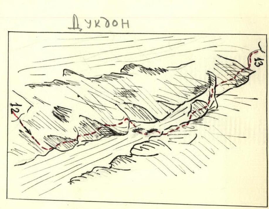
Route diagrams. Dukdon.
View from the north-northeast. Ascent route. Control cairn. Group bivouac.