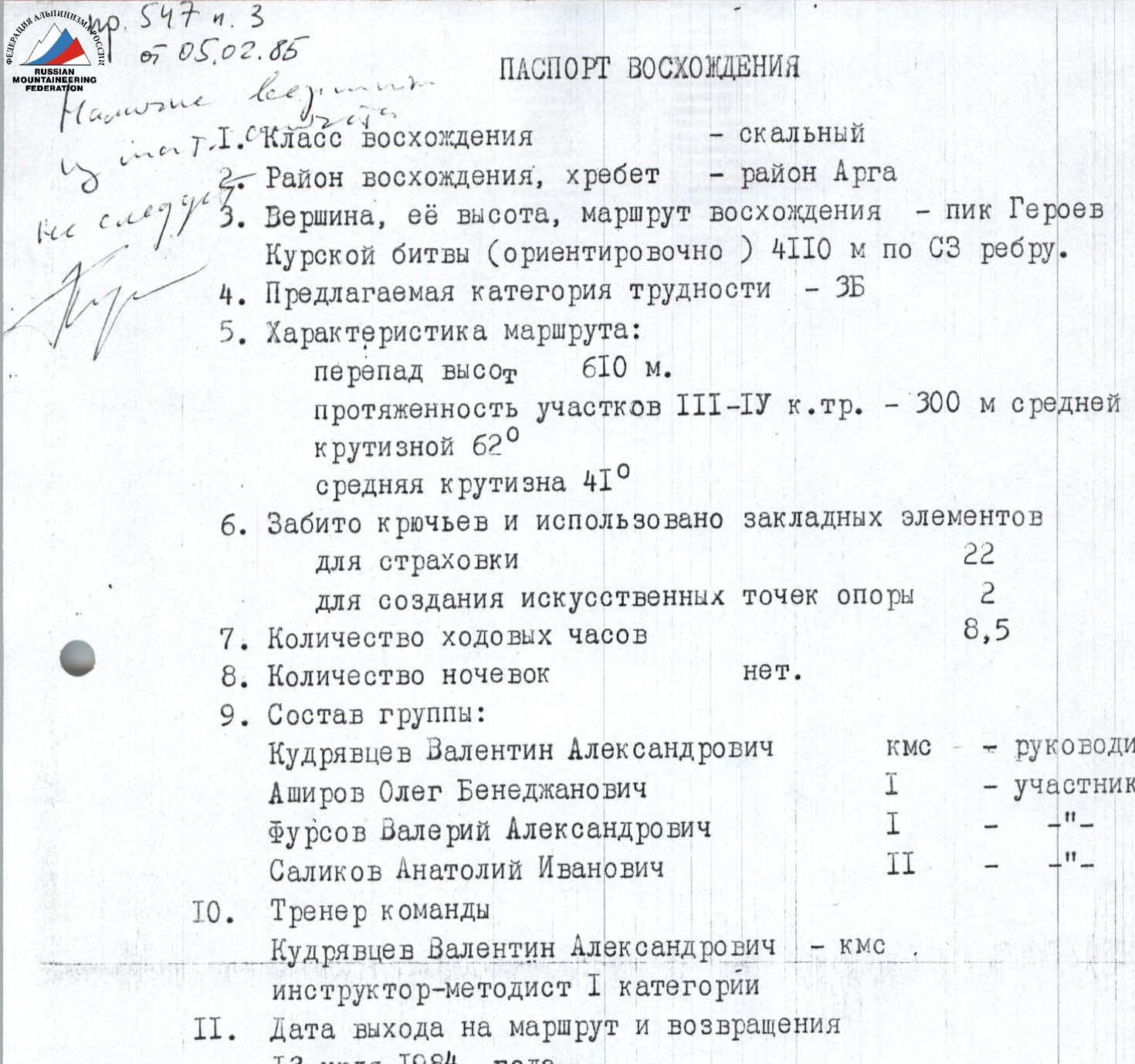
ASCENT DOCUMENT
- Type of ascent — rock climbing
- Climbing area, ridge — Arga area
- Peak, its height, ascent route — Peak Heroes of the Kursk Battle (approximately) 4110 m via NW edge
- Proposed difficulty category — 3B
- Route characteristics: height difference 610 m length of sections with III–IV difficulty category — 300 m with an average steepness of 62° average steepness 41°
- Number of pitons driven and chocks used for belaying 22 for creating artificial holds 2
- Number of climbing hours 8.5
- Number of nights spent no nights.
- Group composition: Kudryavtsev Valentin Aleksandrovich CMS — leader Ashirov Oleg Benezhanovich 1st sports category — participant Fursov Valery Aleksandrovich 1st sports category — participant Salikov Anatoly Ivanovich 2nd sports category — participant
- Team coach Kudryavtsev Valentin Aleksandrovich — CMS instructor-methodologist 1st category
- Date of departure and return July 13, 1984
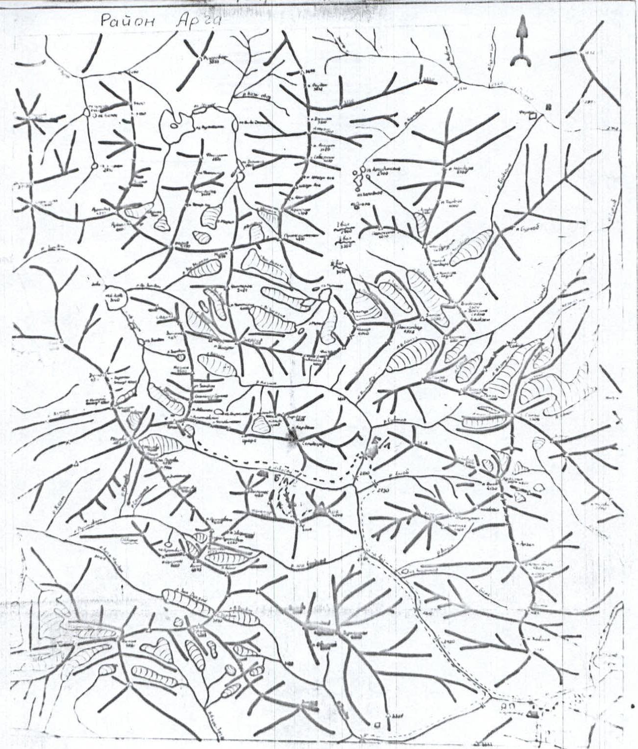
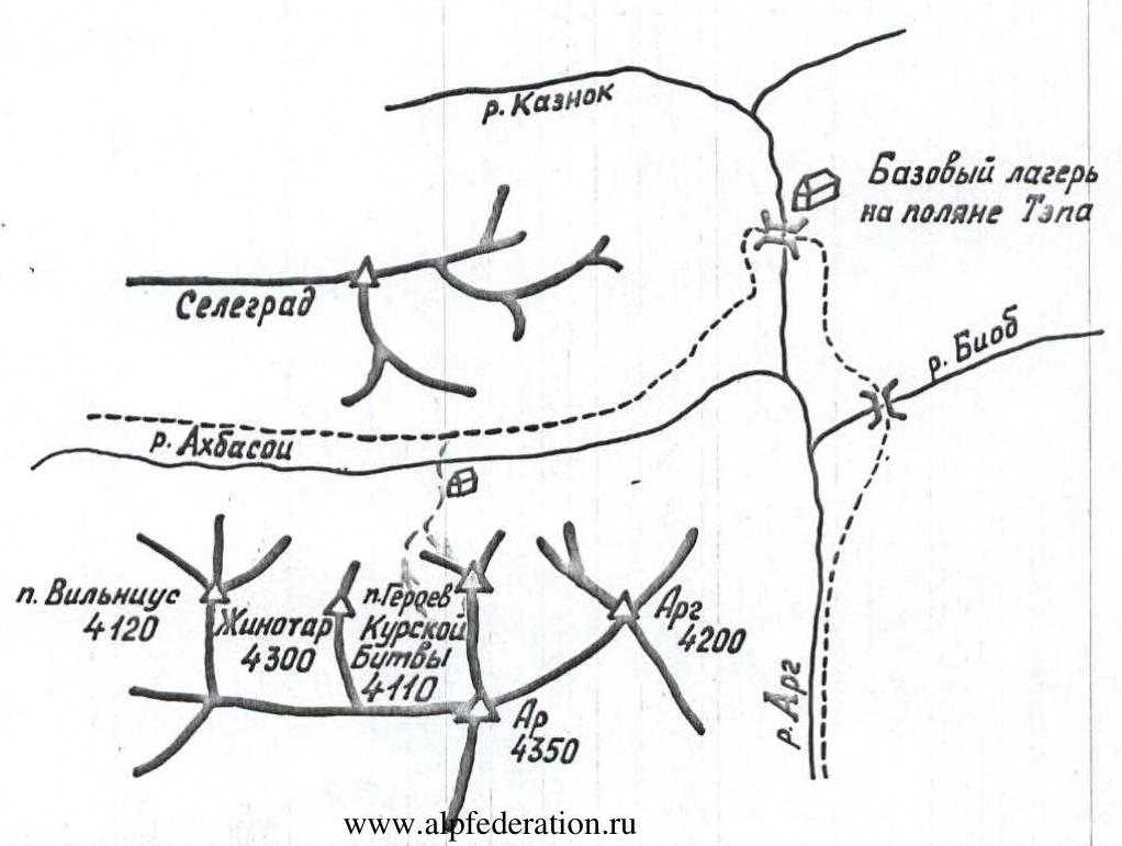
The summit of Peak Heroes of the Kursk Battle (4100) is located in the Fan Mountains in a spur branching off from the Arga peak, separated by scree-filled couloirs from the Arga and Zhinotar peaks. The starting bivouac is a temporary camp on the "Tepa" fields, situated at the confluence of the Kaznok and Akhbasoy rivers, 4–4.5 hours' walk from the village of Sarytag.
There are convenient areas near the river Akhbasoy within an hour's walk from the "Tepa" clearing.
From these areas to the start of the route, it takes 40–50 minutes to walk up the scree slope rising between the Zhinotar peak and Peak Heroes of the Kursk Battle.
Route Reconnaissance
The route was reconnoitered during sports ascents on nearby peaks while staying at the branch of the Varzob alpine camp under a collective permit.
Pre-Climb Preparation
Preparation for the ascent included pre-camp training of candidates for the collective permit and direct preparation in the mountains during the completion of standard ascents for the 1st sports category. The participants had completed 9–11 ascents in the Arga area over the preceding month, with 6 of these ascents being on routes of 4A–5A difficulty category.
Completed ascents:
- Arga peak via NW edge, 5A category — completed by the group in 10 hours;
- Sugar Head peak via NE ridge — completed in 9 hours.
This indicates good physical condition and good teamwork among the participants.
Equipment, food, and first aid kit were selected for a route of 4A–4B difficulty category.
Ascent Tactics
The tactical plan included:
- approaching the route and detailed inspection of the group's path on July 12, 1984;
- starting the ascent and descending to the bivouac on July 13, 1984.
Individual work by rope teams without setting up belays was planned. If necessary, the rope teams were to move in parallel to choose the optimal path.
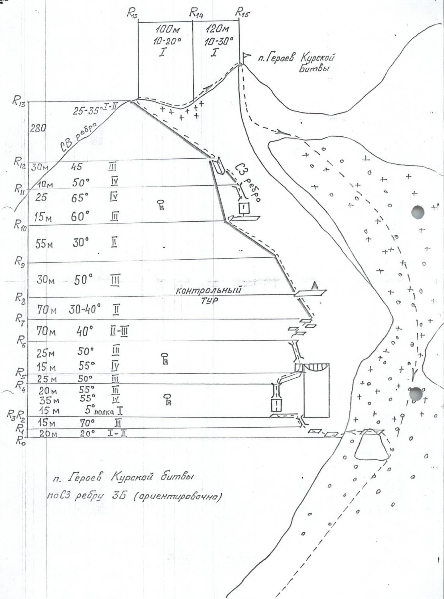
Table of Main Characteristics of the Ascent Route to Peak Heroes of the Kursk Battle via the Northwest Edge on July 12–13, 1984.
Route length — 905 m. Height difference — 610 m. Average steepness of the route — 41°. Average steepness of key sections — 62° over a length of 300 m. Length of sections with IV difficulty category — 85 m, III difficulty category — 215 m. Time taken to ascend to the summit — 8.5 hours. Table 1
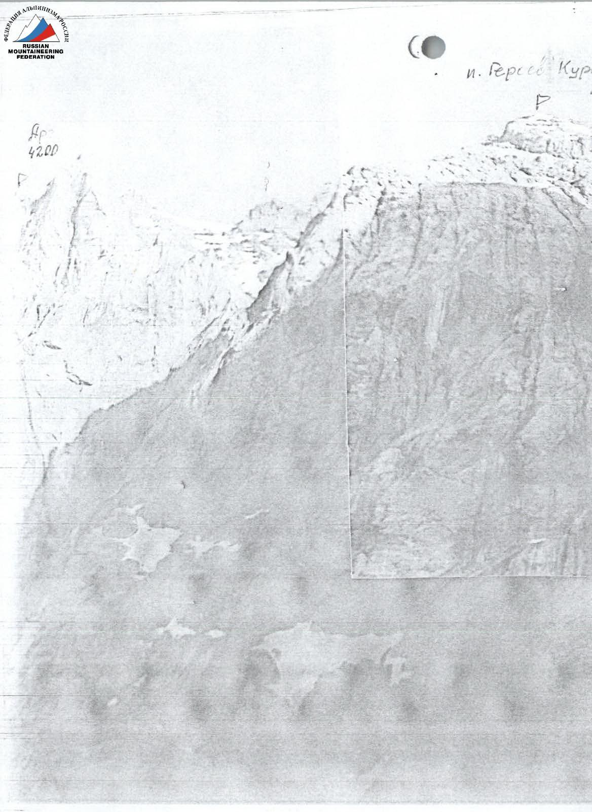
Table 1. Characteristics of Route Sections
| Designation | Average Steepness, ° | Length, m | Terrain Characteristics | Difficulty Category | Condition | Pitons | Chocks | Notes |
|---|---|---|---|---|---|---|---|---|
| R0–R1 | 20 | 70 | Shelves, simple rocks | 1–2 | destroyed | |||
| R1–R2 | 70 | 15 | Crack | 3 | monolithic, convenient holds | 1 | ||
| R2–R3 | 5 | 15 | Shelf | 1 | 2 | |||
| R3–R4 | 55 | 35 | Wall | 4 | monolithic | 2 | 3 | |
| 55 | 20 | Crack | 3 | monolithic | 1 | 1 | ||
| R4–R5 | 50 | 25 | Shelf | 2 | 1 | |||
| R5–R6 | 55 | 15 | Wall | 4 | monolithic, micro-holds | 2 | 1 | |
| 50 | 25 | Crack, chimney | 3 | monolithic | 2 | |||
| R6–R7 | 40 | 70 | Wall with small shelves | 2–3 | destroyed rocks | |||
| R7–R8 | 35–40 | 70 | Ridge | 2 | many projections | Control point at R8 | ||
| R8–R9 | 50 | 30 | Ridge | 2 | projections | |||
| R9–R10 | 30 | 55 | Ridge | 2 | projections | |||
| R10–R11 | 60 | 15 | Wall | 1 | micro-holds | 1 | ||
| 65 | 25 | Crack-chimney | 4 | good, monolithic rocks | 3 | |||
| R11–R12 | 50 | 10 | Ridge | 4 | monolithic | 1 | 1 | |
| 45 | 30 | Internal corner | 3 | monolithic | 2 | |||
| R12–R13 | 25–35 | 280 | Ridge, shelves | 1–2 | destroyed rocks, projections | |||
| R13–R14 | 10–20 | 100 | Ridge, snow | 1 | destroyed rocks, talus | |||
| R14–R15 | 10–30 | 120 | Slope | 1 | destroyed rocks, talus |
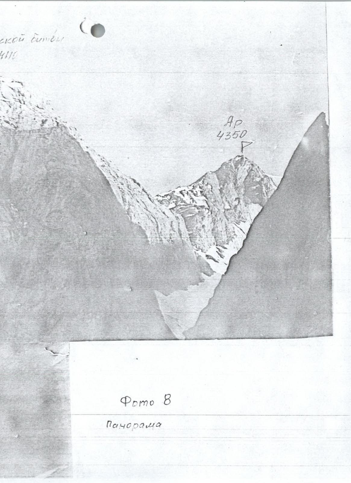
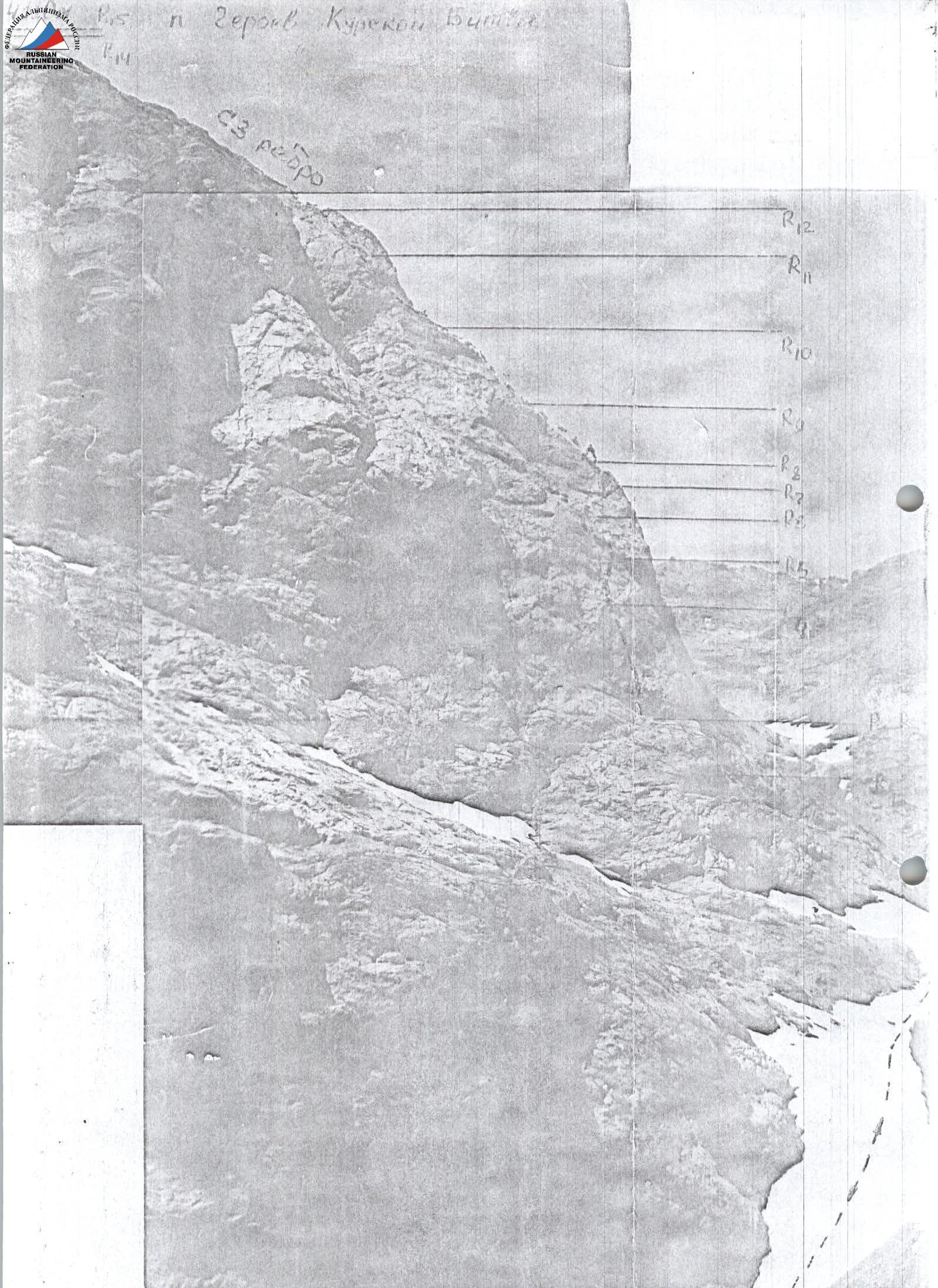
 Photo 7. Section R13–R15. Summit.
 UIAA Scheme
Section R4–R8. Exit from the crack onto a sloping shelf, then ascend up and to the right to reach the edge of the NW ridge wall. There are few places to set up intermediate belays. From the edge of the wall, ascend the laid-back wall with micro-holds to the start of a crack-chimney exiting from under the cornice of the NW ridge wall. Ascend the crack-chimney with good holds and then traverse diagonally rightward along the wall with small destroyed shelves, exiting onto the NW ridge. The further path to the summit follows the ridge. The first control point is located on a wide shelf-platform on the right side of the NW ridge. This shelf is not visible from below. The ascent to the first control point from the bivouac takes about 2.5 hours.
Section R8–R10. The path follows the ridge with simple rocks, where short sections (2–4 m) of moderate difficulty rocks are encountered. Along the ridge, 80–90 m to a wide shelf located on the right side of the ridge under a 120–130 m wall.
Section R10–R12. The path follows the right side of the ridge. First, ascend difficult rocks up and to the right to a vertical crack-chimney. There are few places to set up intermediate belay points on the wall; the crack has many places for large chocks.
The crack-chimney has reliable holds in the form of flaked rocks:
- from the crack-chimney, move left onto the ridge;
- then follow the internal corner with convenient holds;
- exit onto a platform on the ridge, marking the end of the 200-meter ridge ascent.
Section R12–R15. The ridge becomes gentler and less pronounced. There are small snow-covered and wet sections. These sections do not present significant technical difficulties. The length of the ridge with height gain is 200 m. After a pinnacle, there is a slight depression in the ridge, leading to the Summit, a distinct peak.
Descent from the summit is via scree-covered shelves toward Zhinotar peak — 80 m, then 50–60 m traverse leftward along shelves onto scree and snow-covered slopes, and descend to the start of the route. The descent takes about 1 hour.
In total, 905 m were covered, 8 pitons were driven, and 16 chocks were placed.
Brief explanation of Table 1.
From the "Tepa" clearing, follow the trail past Arga peak and approach Peak Heroes of the Kursk Battle. Cross the Akhbasoy river via stepping stones or a snow bridge.
Ascend the narrow scree-filled couloir between Zhinotar peak and Peak Heroes of the Kursk Battle under the NW ridge.
On the scree slope, there is a large rock outcrop with a wide platform at the top. Above us looms the cornice of the terminal wall of the ridge; slightly below, the start of a wide, gently sloping shelf encircling almost the entire northern slope of the peak is visible.
Section R0–R3. In rope teams, traverse the slope leftward along shelves and simple rocks under the NW ridge wall. The wall has a small cornice on the left side, from under which a crack ascends, turning into a chimney at the top. The exit into this crack is after completing sections R0–R5.
To the left under the NW ridge wall:
- through a narrow crack-chimney visible from below as a flake;
- exit left onto a shelf under the wall-slope descending from the NW ridge to the north;
- along the shelf, 10–15 m leftward.
Section R3–R4. From the shelf, ascend up and to the right along the wall to a vertical crack with flakes on the left side.
The wall is of moderate difficulty; the crack has sections requiring difficult climbing to overcome overhanging flakes. The holds in the crack are reliable.