Report on the first ascent of Peak "Vilnius" via the NW buttress, category 3B difficulty

Team of the "Zalgiris" Sports Society. Leader: A. P. Baublis. Coach: A. V. Petrov, Master of Sports. Vilnius, 1973.
1. Introduction. Rationale for the Route Choice
From July 13 to August 13, 1973, sports training camps for Lithuanian mountaineers were organized in the Fan Mountains by the Committee for Physical Culture and Sports under the Council of Ministers of the Lithuanian SSR. Along with other tasks, the camp leadership planned to ascend an unnamed peak and decided to name it "Vilnius" in honor of the city's 650th anniversary. During a consultation with N. Paganucci, a great connoisseur of the Fan Mountains, it was discovered that near the base camp, in the area of the Akhsu River (also known as Akhbaсай), there was a beautiful unnamed peak that was chosen as the object of the ascent.
2. Characteristics of the Ascent Object
Peak "Vilnius" is a rocky massif with steep walls on the east, north, and west sides, and only on the south side does it connect via a narrow pass to the "Zonatar" peak. From this pass, there is a convenient and quick descent via scree to the west. The northern wall connects to the eastern and western ridges, along which two ascent routes to Peak "Vilnius" were planned. Both routes are purely rock climbs, with snow only at the summit and in some places on the northern part of the peak. The approach to the foot of the peak is convenient and takes about 1.5–2 hours of walking from the base camp by the Arg River. The path goes along the right bank of the Akhsu River. After fording the river at the koshi (rapids), one exits directly to the routes. This location has a convenient spot for a bivouac.
3. Organization of the Ascent
3.1. Organizational and Tactical Ascent Plan
Upon arriving in the Fan Mountains, the group completed two joint ascents of category 4A difficulty: to Peak "Skalnaya Stena" (Rocky Wall) and "Bely Bars" (White Leopard). The third ascent object was chosen to be Peak "Vilnius". Later, ascents of categories 3B, 4A, 4B, and 5A were completed in the same group composition. During reconnaissance, two routes to the summit were identified: via the NE ridge and the NW buttress. The routes were preliminarily assessed as category 4A and 3B difficulty, respectively. The ascents were conducted simultaneously via both routes to ensure close communication between the groups. Radio communication was maintained using "Vitalka" radios.
The group took bivouac equipment and provisions for one day. The group had the following inventory:
- 2 main ropes, 40 meters each
- Auxiliary rope — 40 meters (a reepschnur was used to pull up backpacks on the R0–R1 section)
- 14 rock pitons (All-Union Central Council of Trade Unions type)
- 8 carabiners
- 2 hammers
The taken inventory proved to be sufficient. The ascent was made by two rope teams: Baublis — Peštaras and Svirskis — Zakarevičius.
3.2. Group Composition
For the ascent of Peak "Vilnius", a sports group was formed consisting of second-category climbers with 4–5 years of mountaineering experience:
- Leader — Algis Prano Baublis, born 1951, member of the All-Union Leninist Young Communist League (VLKSM), chemical engineer, address: Vilnius, Žeručiio St. 6–23
- Albinas Iono Svirskis, born 1951, member of VLKSM, technician, address: Panevėžys, Tulpių St. 4–20
- Alvidas Vitauto Peštaras, born 1953, member of VLKSM, address: Kaunas, Smėlio St. 29–1
- Linas Iono Zakarevičius, born 1947, member of VLKSM, address: Jonava, Pērgalės St. 7–2
3.3. Route Progression. Section Characteristics
Section R0–R1. Left the bivouac at 9:00. After ascending the scree slope, we approached the start of the route. It's a chimney — the most difficult part of the route. The chimney walls are vertical, smooth, with almost no holds. Climbing is difficult.
Features of the passage:
- In the middle part, the chimney narrows to 0.5 meters, and this section is passed without backpacks, which are later pulled up.
- At the top, the chimney ends with an almost horizontal ledge protruding 5 meters.
- Here, we turned left and moved along an inclined ledge (steepness — 50°, 15–20 meters).
- After passing the ledge and another 10 meters on easy rocks, we reached a convenient platform where we pulled up the backpacks.
Belays on this section were solely via pitons.
Section R1–R2. From the platform, we ascended 15–20 meters up and to the right, then traversed a 10-meter internal corner. We exited onto destroyed rocks (150 meters), which gradually turned into monolithic rocks.
Section R2–R3.
- Monolithic rocks, 250 meters long, steepness 30–40°.
Section R3–R4.
- At the top, these rocks end with a vertical wall.
- We turned left and reached the second serious spot on the route — a chimney.
- The chimney is 75 meters long, steepness up to 70°.
- It's best to overcome it along the left wall.
- Rocks are monolithic, holds are microscopic, movement is on friction.
- Climbing is of medium difficulty, with some difficult parts.
- There are loose rocks inside the chimney.
- The last 15 meters are easily traversed along the chimney itself.
- Then, we turned right and traversed another chimney in a stemming position, 30 meters long, steepness 40°.
Section R4–R5.
- After traversing about 30 meters on monolithic rocks, we reached the shoulder of the ridge.
- We built a control cairn and left a note.
- Further on, there were distinct rock ascents.
- The most difficult was the middle one: 50 meters long, steepness 40°.
- Pitons were required for belays.
Section R5–R6.
- 150 meters on easy, destroyed rocks, which ended with a gendarme.
- By passing the gendarme on the right, we overcame a monolithic rock dome of the "sheep's foreheads" type, 70 meters long, steepness 25–30°.
Section R6–R7.
- 400 meters along the destroyed pre-summit ridge, which ended with two elevations (150 meters between them).
- On the second elevation, together with the group that ascended via the NE ridge (leader: Candidate for Master of Sports Yu. Yurgelionis), we built a control cairn.
- This is the summit.
Section R7–R8.
- Descent from the summit via scree.
5. Conclusions
5.1. Assessment of the Group's Actions
The ascent participants were well-prepared for overcoming the route, making it hard to single out anyone. Everyone acted cohesively and attentively.
5.2. Route Assessment
The route is interesting, technically challenging enough, and left a pleasant impression on everyone.
- The choice of a difficult start to the route is considered logical because, although it's challenging, it's short and quickly leads to a route of the 3rd category of difficulty.
- It's possible to go left along the wall, but it's much longer and, in our opinion, would be at least category 4 difficulty.
- On the right, this wall is shorter, but it ends with negative angles everywhere in the upper part.
The route is recommended to be traversed only in good weather — in Vibram shoes, with the first climber in galoshes.
Group Leader (A. Baublis)
5.3. Route Characteristics Table
Route — Peak "Vilnius" via NW buttress, category 3B. Summit height — 4120 meters Height difference — 700 meters Steepness — 40° Number of difficult sections — 2
Ascent completed on July 31, 1973.
| Section | Steepness | Length | Difficulty | Belay | Start | End | Duration | Number of Pitons |
|---|---|---|---|---|---|---|---|---|
| R0–R1 | 80° | 40 m | difficult climbing | pitons | 10:00 | 12:00 | 2 hours | 6 |
| R1–R2 | 30° | 180 m | easy | 12:00 | 12:20 | 20 minutes | ||
| R2–R3 | 30–40° | 250 m | medium | 12:20 | 12:45 | 25 minutes | ||
| R3–R4 | 70° | 105 m | difficult | pitons | 12:45 | 13:45 | 1 hour | 5 |
| R4–R5 | 30–40° | 140 m | medium-easy | pitons | 13:45 | 14:30 | 45 minutes | 1 |
| R5–R6 | 25–30° | 220 m | easy | 14:30 | 14:50 | 20 minutes | ||
| R6–R7 | 15–20° | 550 m | very easy | 14:50 | 15:10 | 20 minutes | ||
| R7–R8 | 40–45° | 300 m | easy | 45 minutes |
Group Leader (A. Baublis)
 Ascent area diagram and route to Peak "Vilnius".
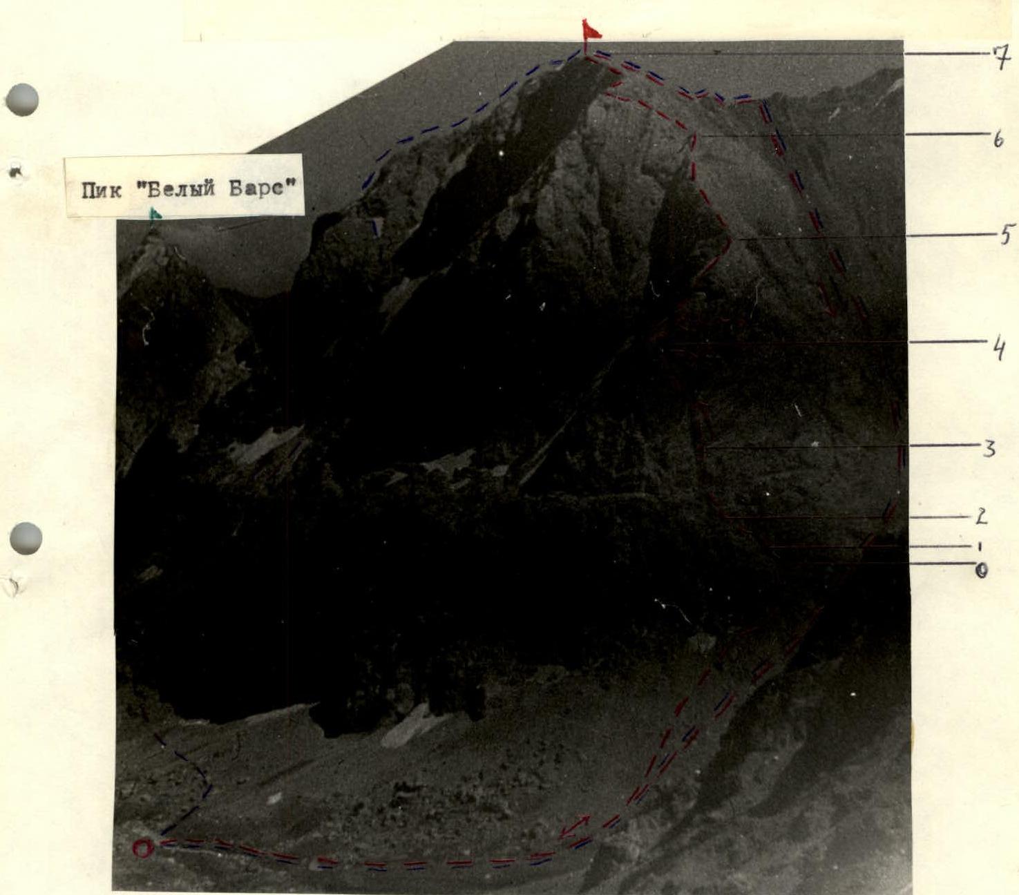 Route to Peak "Vilnius" via the NW buttress, category 3B. The route via the NE ridge, category 4A, is shown with a dashed line on the left. Peak "Bely Bars" (White Leopard).