PASSPORT
-
Rock climbing category
-
Fann Mountains, Arg valley
-
Peak Arg, 4200 m, via the north wall (variant by A. Maly)
-
Category 5B difficulty
-
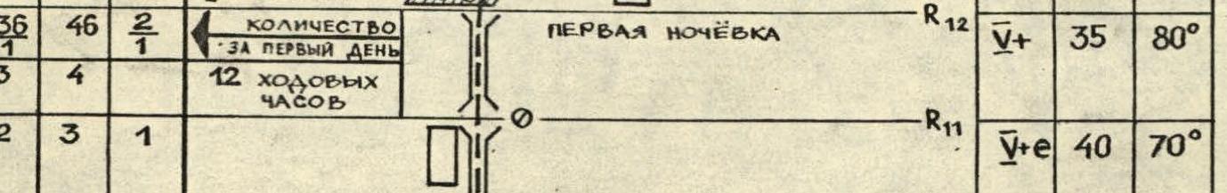
Elevation gain 1200 m
route length 1805 m, including 525 m of category U–U1 sections
-
Pitons used:
rock pitons: 78 bolt pitons: 6* chocks and nuts: 83 6 + 5* 1* 4
-
Climbing hours — 34, days — 3
-
Overnight stays 2 — lying down
-
Team leader: Andrey Yu. Bobylyov, 1st sports category
Team members: Mikhail M. Davy, 1st sports category; Oleg I. Skokov, 1st sports category; Alexander V. Suvorov, 1st sports category
-
Coach: Alexey V. Lebedikhin, Master of Sports of International Class
-
Departure to the route — August 10, 1987
summit reached — August 12, descent — August 12
-
Organization — Sverdlovsk Regional Sports Committee
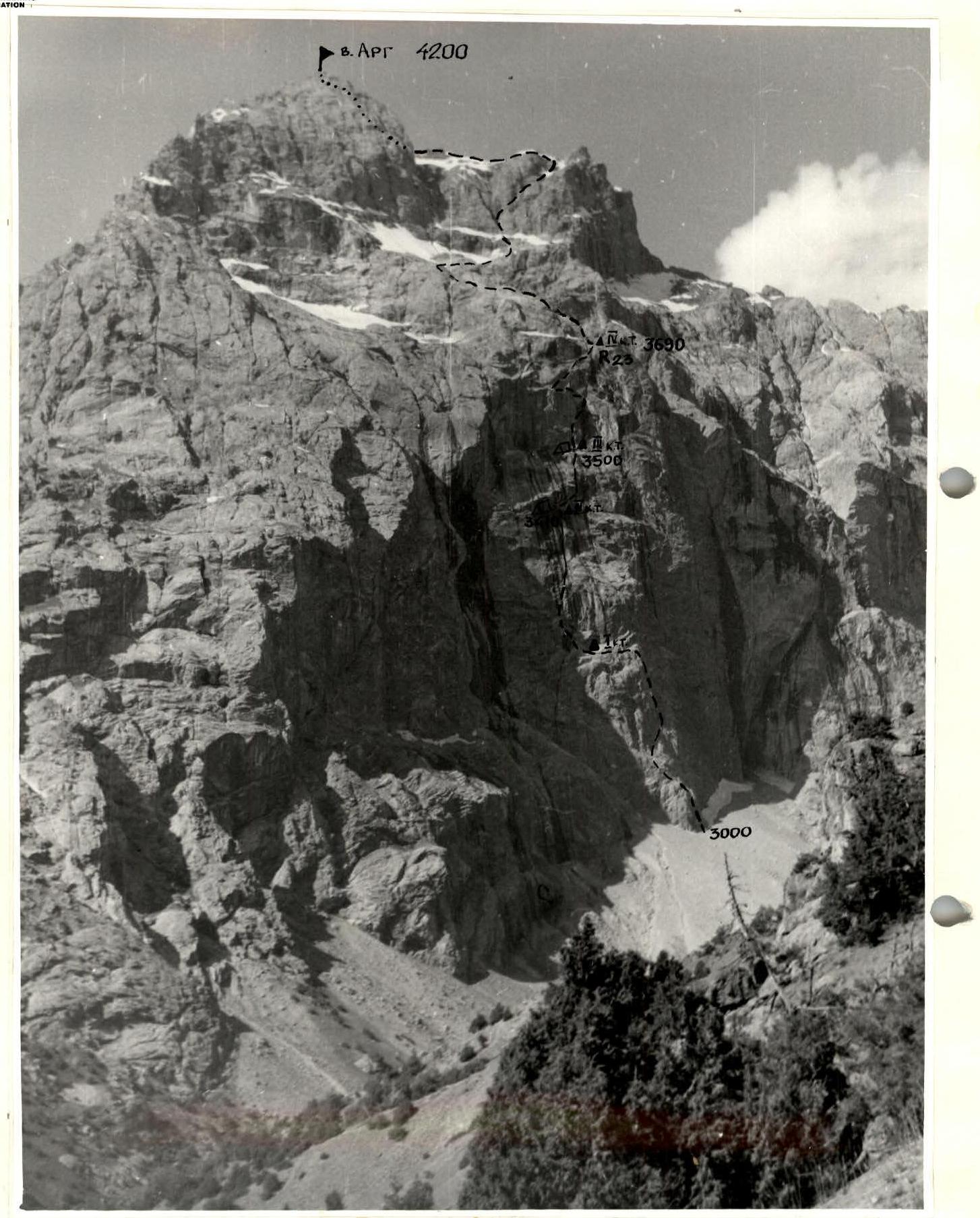
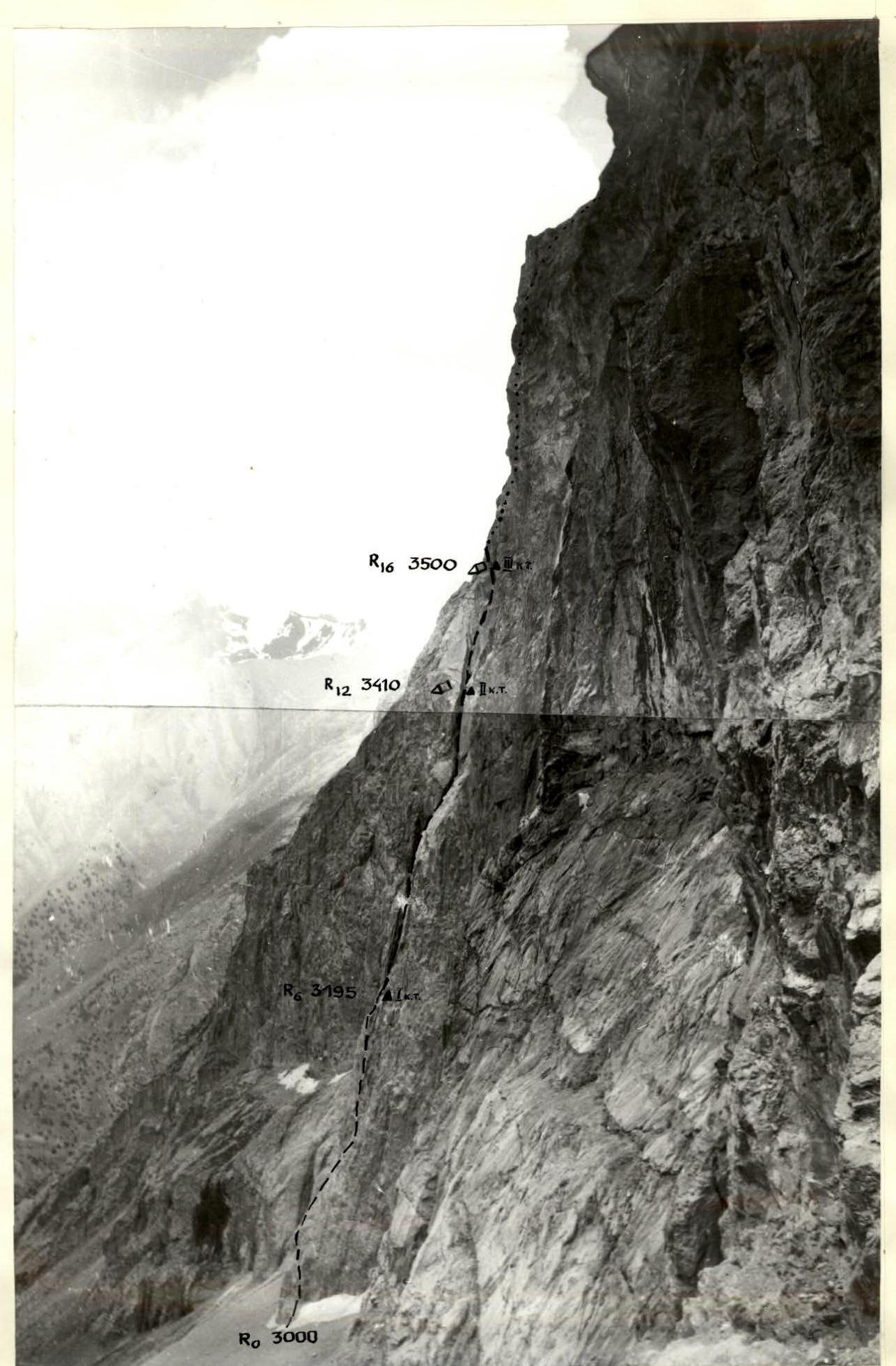
PHOTO OF THE WALL PROFILE FROM THE RIGHT (FROM ROUTE 5A category) (SHOOTING POINT №2) DISTANCE – 400 m CAMERA «SMENA 8M» (LENS T-43)
Tactical Actions of the Team
Tactically, the ascent plan included two options for completing the route — with one and two overnight stays. This was due to the lack of detailed information about the route's character and condition (no detailed description or consultations were available) and unstable weather.
Overall, the team followed the second variant, although with some deviations. On the first day of the ascent, the tactical plan was fully executed; however, it became clear that completing the route would require maximum effort and skill, as the already challenging smooth walls with minimal holds were further complicated by water flowing down them in many places (a snowy winter, a cold summer, and warm weather during the ascent caused intense snowmelt on the bastion's roof).
On the second day of the ascent, the route became even more challenging and steeper. The team reached category III difficulty at 15:00 and continued moving upward. However, it soon became apparent that completing the remaining five rope lengths to category IV difficulty, especially sections R18–R20, would take a significant amount of time, and reaching the overnight stay location would be delayed until late evening. The situation was further complicated by deteriorating weather, with snow starting to fall.
Under these conditions, the team made a tactically correct decision:
- to bivouac at category III difficulty, where a small platform was available;
- to prepare the key section of the route.
Davy and Skokov descended to category III difficulty, where they worked on expanding the platform, enabling a lying-down overnight stay. Meanwhile, Bobylyov and Suvorov continued upward, processed three rope lengths, and then descended to the bivouac site.
On the following day, using fixed ropes, the team quickly approached category IV difficulty, reached the summit, and descended to the base camp.
Throughout the wall section of the route, the team employed alternating movement with rope management between teams. The first to lead were:
- Bobylyov — on sections R0–R12;
- Skokov — on sections R12–R18;
- Suvorov — on sections R18–R23.
After reaching the top of the bastion and onwards to the summit, the team moved in autonomous pairs on a shortened rope. On sections requiring alternating movement, protection was provided using rock features.
The team utilized a wide range of modern equipment during the ascent:
- titanium pitons and carabiners;
- chocks and nuts of various shapes and sizes from 4 to 120 mm;
- extension loops;
- rope clamps;
- etriers.
One of the relatively new pieces of equipment used was "friends". On overnight stays, a homemade frame tent was used, which was easily set up on any terrain, and an autoclave, which allowed for saving time and fuel when preparing meals.
The team had four ropes (one of which was made in the GDR), allowing each member to climb on a double rope. The lead climber moved without a backpack, and everyone wore galoshes. To ensure maximum safety for the lead climber, a shock absorber was used. Belay stations were organized on pitons whenever possible, sometimes on chocks, using opposition systems.
The regime of movement, rest, and nutrition included two hot meals a day — in the morning and evening, in addition to individual snacks on the route consisting of sausage, chocolate, dried fruits, and two flasks of drink. Snacks were consumed without stopping the team's movement, during forced pauses.
Overnight stays were organized in safe locations on platforms large enough for four people to rest lying down. The first bivouac site was a ready-made platform, and the second site required expansion to the necessary size. During overnight stays, all team members were on self-arrest.
Overall, the team completed the route confidently, without undue haste, with a sufficient margin of safety, facilitated by the high physical and technical preparation of all team members.
Communication with the base camp was maintained via radio five times a day, and the team also had flares in case of an emergency.
A rescue team consisting of 6 people with CMS and 1st sports category qualifications was stationed at the base camp on the Tepa meadow, within 30 minutes from the start of the route, and was prepared to provide quick and qualified assistance to the team if needed.


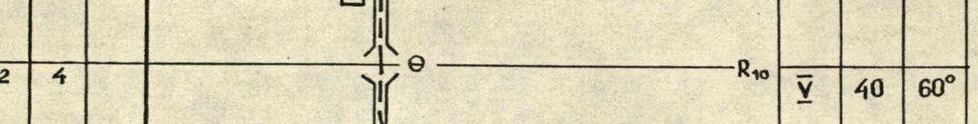
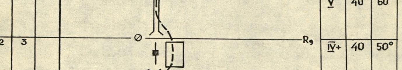

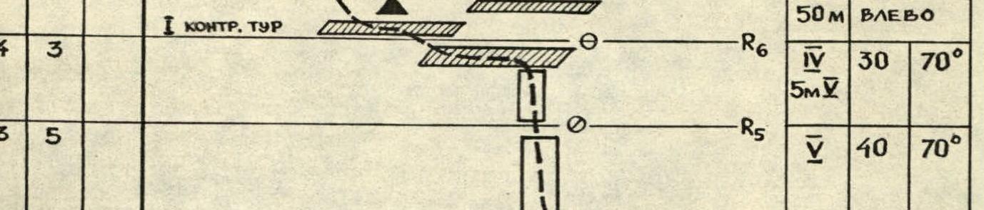
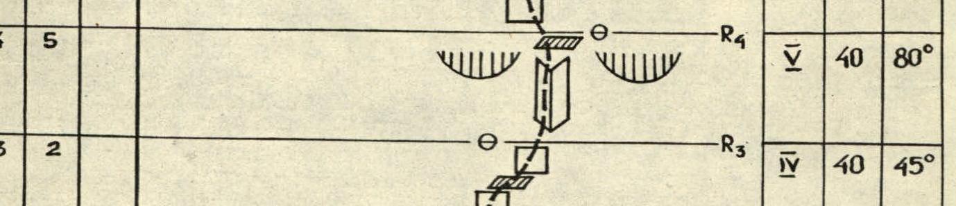


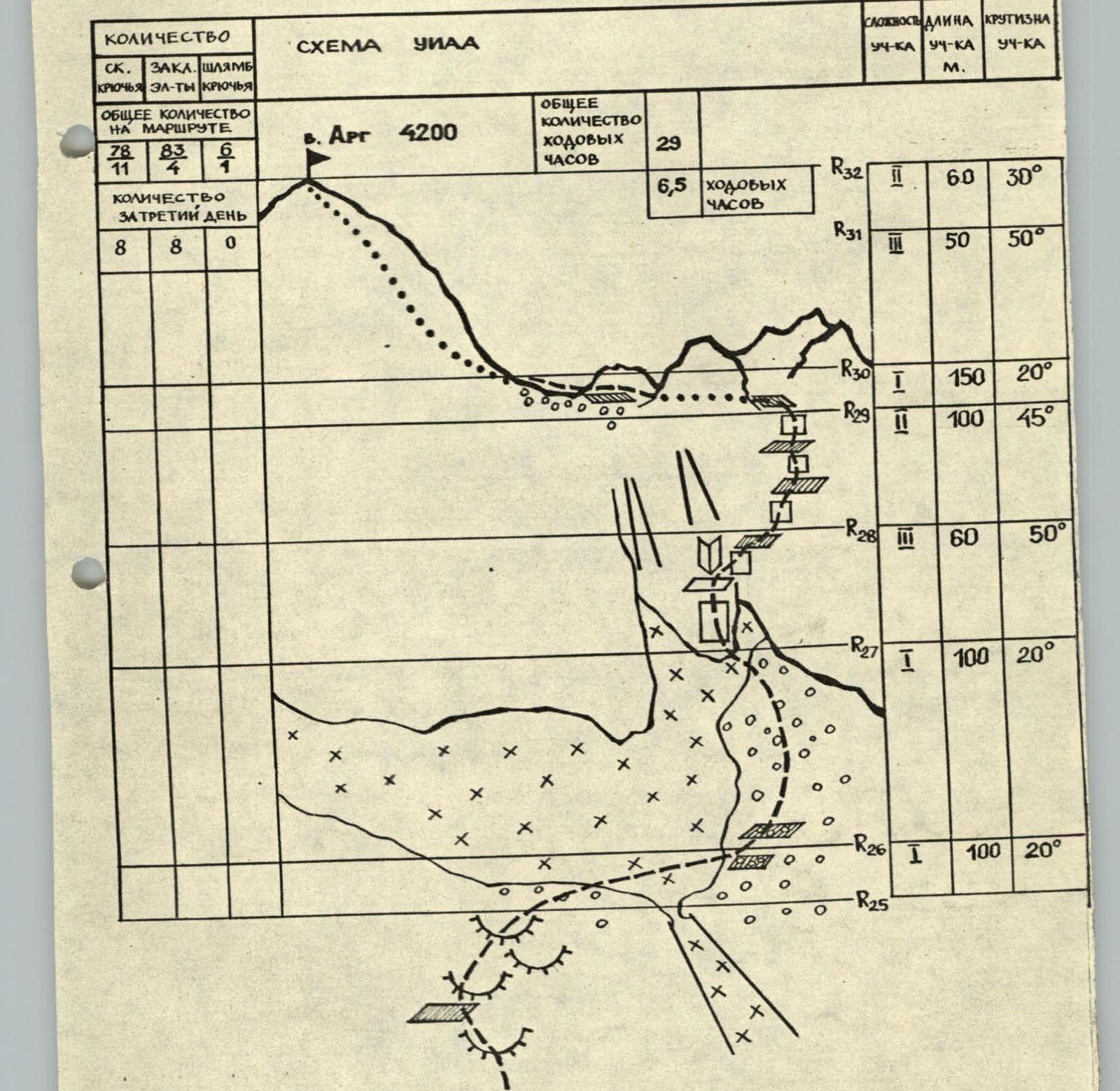
ROUTE DESCRIPTION BY SECTIONS
The route to peak Arg via the north wall is one of the most challenging in the area. Tajik climbers refer to it as the "little six".
The entire route can be conditionally divided into two parts. The upper part does not pose significant difficulties, while the lower, more challenging part ("The Bastion") is a rock wall with an average steepness of 65°. The lower section of the wall is more gentle, becoming steeper towards the top, and is capped with cornices and overhangs across its width. The relief of "The Bastion" is weakly articulated and consists of smooth rocks with small holds. Waterfalls cascade down the wall from the top, limiting the "corridor" leading to the summit.
Movement is primarily along:
- chimneys and
- internal corners,
complicated by water flowing through them.
The route starts approximately in the central part of the wall, along the center of a not very pronounced wide counterfortress about 200 m high.
The first 60 m feature broken rocks, with live rocks on ledges. The next 20 m are monolithic rocks with very small holds. There are few cracks for pitons and chocks. This section is traversed on friction and ends at a small ledge. Further movement goes right and up.
The first 40 m do not present serious difficulties but have unfavorable relief for organizing a belay station at the top. Above, the rocks become steeper (80°). The path goes up, first along a not very pronounced, nearly vertical internal corner (40 m), and then along a wall (40 m) with good holds.
Further on, the rocks become gentler but more monolithic. Holds here are small, and some places are traversed on friction. This section (30 m) ends at a wide, inclined ledge ("terrace"), where the first control cairn is located.
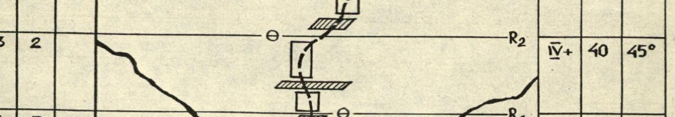
The path then proceeds along a highly articulated wall (40 m) with good holds, starting from the left side of the "terrace" and leading into a wet chimney. Water flows down the chimney walls. The holds are smooth and sometimes covered with slippery dirt. The lower part (30 m) of the chimney is nearly vertical and is traversed using artificial aids.
Above, the chimney becomes gentler and is bypassed on the right and left along monolithic dry rocks. After 60 m (from the start of the chimney), the chimney turns into a crack. This section (20 m) is bypassed on the right along smooth rocks with very small holds, mainly on friction. There are few places to hammer in pitons or place chocks.
Then, another chimney begins (115 m). Water flows through this chimney, and some sections are bypassed on the right and left. The rocks in this section are monolithic, with small holds and few cracks for pitons and chocks. An old bolt piton is used for protection. The chimney leads to a "grotto". Here is the second control cairn and a good spot for an overnight stay.
When organizing a bivouac in this location, there's an issue with water. It can be collected by catching drops falling from the overhanging cornice above the grotto.
From the grotto, move right for 25 m along broken rocks to an inclined ledge with live rocks, from which a chimney starts upward. In its lower part, the chimney is very wide and is bypassed on the right along a wall (40 m) with small holds. The rocks here are monolithic. Protection is provided using "friends". Above, the chimney narrows, and the next 30 m are traversed within it. This section has few cracks, and an old bolt piton is used for organizing a belay station. Further, the chimney becomes less pronounced. The rocks become gentler (up to 45°) and simpler. Move straight up for 40 m to a small ledge, where the third control cairn and a spot for an overnight stay are located.
Above the ledge, another chimney begins, with a steepness of 80–65°, transitioning into an internal corner. In its lower part, the chimney is wet, and the first 40 m can be bypassed on the right along a wall and an internal corner. In the upper part, the rocks become broken. Then, move 20 m up and right under monolithic negative walls along a wall with good holds to an internal corner. To the right, a wet chimney is visible, becoming overhanging and very wide at the top. This is the start of the key section of the route. From here, move left of the chimney, straight up for 15 m along a vertical internal corner transitioning into a negative wall. Water constantly drips from the cornices above. The rocks are wet and unreliable. The section is traversed using artificial aids with the help of pitons and chocks. The wall leads to a monolithic inclined slab. From here, traverse left for 30 m, first along the slab under the overhanging rocks and then along a vertical wall to an inclined ledge, where two bolt pitons are hammered. The section is traversed using artificial aids. From the ledge, a slightly overhanging wall begins (40 m). It is bypassed on the left along a chimney and then along an inclined internal corner to the right. Here, there are good holds, and traversing this section does not present difficulties.
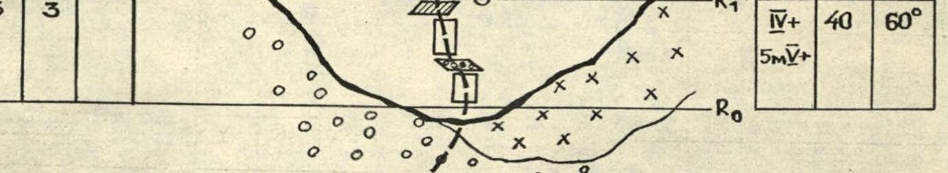
Further, the route goes right and up for 40 m along a wall with unreliable holds and exits into a "green" couloir (30 m), which leads to the top of the bastion. Here is the fourth control cairn and a good, large platform for an overnight stay. To the right, a large, deep snowy couloir is visible, leading to the base of the summit tower. Move left of the couloir along the "ram's foreheads" and ledges in the direction of the saddle between the summit and the "yellow" gendarme. This and the following sections do not present difficulties. The average steepness is 45°. After traversing right along the snowfield under the summit tower, move towards the rightmost couloir leading to the saddle between the summit and the "yellow" gendarme, and then 20 m along smooth rocks to the left of it. Then, cross right onto the broken rocks of the "yellow" gendarme and move along them, first right and up, and then left to the saddle. From here, the path to the summit goes along the monolithic rocks of the summit tower with an average steepness of 45°.
Footnotes
-
V. Arg. PHOTO FROM THE SLOPE AT THE FOOT OF PEAKS SELEGRAD AND LARDASH (SHOOTING POINT №1) DISTANCE – 2 km. CAMERA «LUBITEL 166» (LENS T-22) ↩