Ascent Passport
I. Ascent Class
- Rock climbing
- Ascent Area
- Pamir-Alai, Fann Mountains
-
Ascent Route — North face of peak Arg — third ascent — 5B category of difficulty
-
Ascent Characteristics
height difference 1100 m; average steepness of the wall 80°, length of complex sections 870 m.
- Pitons Driven
rock 194, ice –, bolted 6
-
Total climbing hours – 39
-
Number of overnight stays — 3 (one sitting, one half-lying, and one lying)
-
Team of sports tourist camp "Varzob"
-
Team Members
Grushevsky Valery Grigorievich CMS — team leader Prisyazhny Vladimir Pavlovich MS — participant Belyntsev Vyacheslav Timofeevich CMS — participant Solovyov Mikhail Alexandrovich CMS — participant
- Team Coach — Sogrin Sergey Nikolaevich
II. Ascent Completed
July 8, 1978 — departure for the route
July 9, 1978 — work on the route
July 10, 1978 — work on the route
July 11, 1978 — ascent to the summit and descent to Base Camp
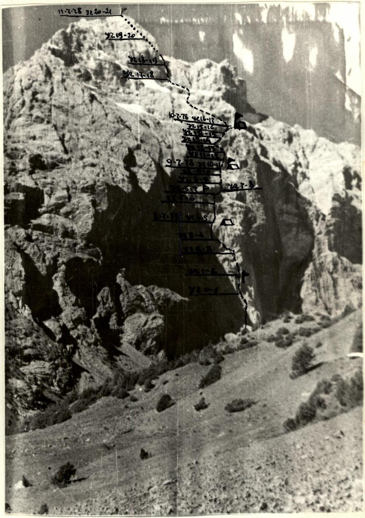
The ascent route runs along the north wall of peak Arg and is the third ascent. The height difference of the wall is about 900 m. The average steepness of the wall is just over 80°. Climbing is mainly chimney climbing, technically difficult, with repeated passage of cornices. The wall itself is monolithic and quite steep.
Consultations on the route passage and description were obtained at the sports tourist camp "Varzob". The group's tactics were as follows:
- Approach to the route from the base camp at "Tepe" and ascent to the wall without prior processing.
- Water was available on the route, making our task easier in terms of drinking.
- The first pair processed the route, hanging fixed ropes, and the next pair moved along the hung ropes using jumar ascenders, carrying backpacks "American style".
- The group used rope hauling only once, when passing the last giant cornice. The backpacks were then thrown 15 m away from the wall.
On July 8, the group approached the route by 8 am and began work. From the very beginning, the route starts with difficult climbing. The first climber goes without a backpack on a single 11-mm Austrian rope. Somewhere at the end of the second rope, in the upper part of the internal angle, a control cairn hangs on the wall. Apparently, water had entered the container with the note, as only tattered scraps of paper remained from the note. After the internal angle, the route continues along a monolithic wall towards a visible niche. Climbing is difficult. The wall ends with three steps of ledges. From the upper ledge, left and upwards, under the beginning of a chimney.
The lower part of the chimney is narrow (60 cm). In the upper part, shale rocks protrude outwards, forming cornices. Climbing is difficult, with the use of ladders. The upper part of the chimney is damp. The exit is through cornices into a blind crack, where a sitting bivouac was organized.
On July 9, the first pair, changing the lead climber (Solovyov went first), began work. From the crack, there is an exit to a monolithic wall without holds. Two bolted pitons were driven. Above, the wall leads to an internal angle. Along the left wall, through an overhanging rock — exit into a chimney. Climbing is difficult, with the use of artificial support points. The chimney is damp. The steep chimney leads to a scree-covered inclined ledge. The exit from the chimney is blocked by a plug. In the left part of the ledge is the second control cairn. A note from the group that made the second ascent was retrieved.
Above the ledge, a huge rusty cornice overhangs, which is traversed to the right along the ledge. Further, a 10 m traverse to the right to the beginning of a wide, damp chimney with a plug at the top. The weather is not favorable: clouds are gathering, and it is drizzling.
The ascent through the chimney is difficult, so it is better to:
- move up to the right along a narrow little ledge,
- then bypass the chimney on the right along the wall,
- exit to the plug.
Again, ascent through the chimney, bypassing an overhang on the right in the upper part — the pair exits into an internal angle. Along a vertical internal angle (unstable rocks), then along a slab — exit to a narrow ledge. In the left part of the ledge is the 3rd control cairn.
The group is forced to stop for the night due to bad weather. The bivouac is satisfactory, half-lying. Snow starts to fall.
July 10, 1978. The weather improves. The same pair, changing the lead (Grushevsky goes first), begins the ascent to the right towards a chimney.
- Along the chimney 10 m, bypassing an overhang on the right, and again up a narrow, damp chimney. Climbing is very difficult. Holds are slippery.
- In the upper part of the chimney, there is a plug, which is bypassed on the right through a little cornice.
- Then movement left and up towards the right wing of a giant cornice, under which are large detached slabs of light grey color.
- The approach to them is very difficult, climbing with the use of ladders. It is necessary to drive bolted pitons.
- The cornice is traversed to the right along a crumbling chimney and further through a cornice. The most difficult section is exactly at this place. The group had to haul their backpacks.
- Above the cornice, an internal angle leads to a wide balcony.
- Along the balcony (these are detached monolithic slabs) to the left — a traverse to a cracked slab fixed from below.
- Along the slab — exit to a steep slab and traverse to the right towards a vertical internal angle.
- Along the angle and a sheer wall, they ascended to a narrow horizontal ledge.
- From above, streams of water flow onto the ledge, so it is necessary to pass the ledge under a cold shower.
- Along the ledge to the right towards the lower part of a couloir and along the right part of the couloir — exit to a green terrace.
Here is our third bivouac, and here is the fourth control point of the first ascenders.
July 11, 1978. The group in full strength ascends to the summit. Above the terrace is a rocky massif, which is passed on the left. Then along snow in the direction of a couloir separating the summit tower and a gendarme. Starting the ascent along the right part of the couloir, we overcome a 25-meter wall, ascend to gentle rocks turning into a snow-ice slope. Along the slope, we ascended to a saddle between the black gendarme and the summit. Further:
- Ascent to the summit
- Descent from the summit to the saddle
- From the saddle along the southern side of the slope of peak Arg down to the Arg River
- Then along the trail, we return to the camp at "Tepe"
Team leader V. Grushevsky
Table of main characteristics of the ascent route to peak Arg along the north wall


D — bivouac location P — control cairn ---- route passage
| Date | Section | Avg. steepness | Length | Terrain characteristics | Difficulty | Condition | Weather conditions | Rock | Ice | Bolted |
|---|---|---|---|---|---|---|---|---|---|---|
| July 8, 1978 | 1 | 80° | 40 m | Internal angle | 5 | monolithic | good | 6 | – | – |
| 2 | 70° | 20 m | Wall, ledge | 5 | good holds | – | 4 | – | – | |
| 2 | 50° | 60 m | Internal angle | 5 | monolithic | – | 11 | – | – | |
| 3 | 50° | 35 m | Wall | 5 | smooth | – | 5 | – | – | |
| 3 | 40° | 15 m | Wall with ledges | 4 | broken | – | 3 | – | – | |
| 4 | 35° | 60 m | Large ledge, traverse left | 4 | – | – | 5 | – | – | |
| 5 | 80° | 45 m | Chimney, upper part cornice | 5 | monolithic | – | 11 | – | – | |
| 5 | 70° | 15 m | Blind crack | 5 | – | – | 4 | – | – | |
| Departure at 8:00, stop for the night at 20:00. Sitting bivouac, poor. | ||||||||||
| July 9, 1978 | 6 | 80° | 20 m | Smooth wall | 6 | monolithic, smooth | satisfactory cloudiness | 8 | 2 | – |
| 6 | 90° | 40 m | Chimney | 6 | smooth, wet | – | 12 | – | – | |
| 7 | 85° | 30 m | Internal angle | 5 | monolithic | – | 7 | – | – | |
| 7 | 75° | 30 m | Chimney | 5 | few cracks | – | 5 | – | – | |
| 8 | 60° | 60 m | Steep ledge | 5 | broken | – | 16 | – | – | |
| 9 | 80° | 10 m | Smooth wall | 5 | wet, smooth | – | 5 | – | – | |
| 9 | 90° | 50 m | Chimney with plug | 5 | – | – | 12 | – | – | |
| Departure at 9:00, stop for the night at 19:00. Satisfactory bivouac — half-lying. | ||||||||||
| July 10, 1978 | 10 | 90° | 50 m | Wall | 5 | monolithic | – | 9 | – | 2 |
| 11 | 80° | 20 m | Internal angle | 5 | – | cloudy, snowing | 4 | – | – | |
| 11 | 80° | 30 m | Slab | 5 | – | – | 6 | – | – | |
| 12 | 80° | 10 m | Chimney | 5 | water flowing | good | 3 | – | – | |
| 12 | 90° | 50 m | Narrow chimney | 5 | – | – | 5 | – | 3 | |
| 13 | 80° | 25 m | Wall with detached slabs | 5 | destroyed | – | 4 | – | – | |
| 13 | 95° | 10 m | Wall leading | 6 | monolithic | – | 9 | – | – | |
| 13 | 100° | 25 m | Cornice traversed along chimney | 5 | – | – | 2 | – | 1 | |
| 14 | 80° | 40 m | Chimney | 5 | water flowing | – | 10 | – | – | |
| 14 | 40° | 20 m | Balcony leading to cracked slab | 5 | destroyed | – | – | – | – | |
| 15 | 80° | 20 m | Cracked slab fixed from below | 5 | – | – | 4 | – | – | |
| 15 | 40 m | Internal angle | 5 | – | – | 6 | – | – | ||
| 16 | 60° | 60 m | Narrow ledge | 5 | water flowing | – | 10 | – | – | |
| 17 | 60° | 60 m | Couloir leading to terrace | 4 | destroyed | – | 6 | – | – | |
| Departure at 9:00, stop for the night at 20:00. Excellent bivouac. | ||||||||||
| July 11, 1978 | 18 | 45° | 300 m | Bypassing rocky massif | 4 | destroyed, ledges | – | 4 | – | – |
| 19 | 60° | 75 m | Couloir | 4 | – | – | 10 | – | – | |
| 20 | 60° | 100 m | Snow slope | 4 | dense snow | – | – | – | – | |
| 21 | 45° | 100 m | Ascent from saddle | 2 | – | – | – | – | – | |
| Departure from bivouac at 8:00, ascent to summit at 14:00. Descent to base camp via route 1B. |