Energy. 4A. Via the Eastern Ridge.
Table of Contents
From the author:
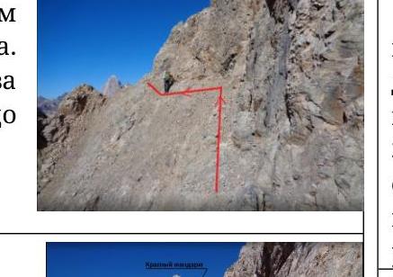
- Passage log
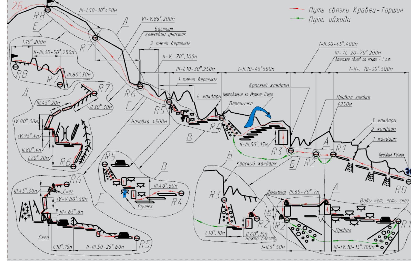
- Route in UIAA symbols
- Approach description
R0–R1. Start from the overnight stay on the Kaznok Pass — 7:00
R1–R2. At station R2 — 11:00
R2–R3
R3–R4
R4–R5. Overnight stay reached — 18:00
R5–R6. Start from the overnight stay — 7:00
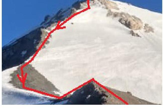
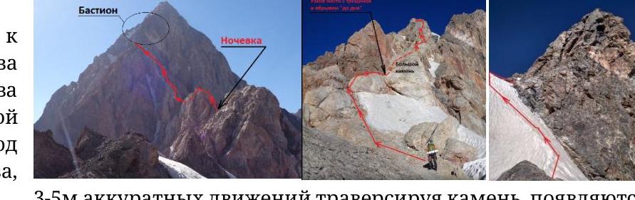
R6–R7. The Bastion
R7–R8. Summit reached at 16:40
Descent. 2B to the pass between Energy and Chimtarga. Started at 17:00. Below the pass on the trail — 19:00
Appendix
Energy. 4A. Via the Eastern Ridge.
From the author:
This report was compiled by Konstantin Kravtsov (MAI Alpine Club) based on the ascent to Peak Energy from August 4 to 6, 2018 (including the approach). The ascent was made by a duo — Konstantin Kravtsov and Denis Torshin (MAI Alpine Club). The goal of this report is to update the route description without any claims to the beauty of the sport style or championship ambitions, so as many photos and human, non-technical comments as possible are included in the full version. For convenience, a brief route description is provided in the appendix, which can be printed on both sides, laminated with tape, and taken on the ascent. I hope this report will be useful to everyone heading to the Fann Mountains and planning to ascend the remarkable Peak Energy via this route.
The UIAA scheme is made as a mirror image of the route photo because 80% of the route is on the left part of the ridge.
Passage log.
-
- Climbing type: technical
- Climbing area: Tajikistan. Gissar-Alay. Zeravshan Range. Fann Mountains.
- Summit, climbing route: p. Energy (5150 m) via the Eastern Ridge.
- Difficulty category: 4A
- Route characteristics:
Height difference: 1063 m. Length of section with 5th category difficulty: 55 m. Total length of the ridge: 2800 m.
- Number of walking hours: 17 — first ascenders, 28 — Kravtsov (due to a mistake on the key section).
- Overnight stay on the route: 1. Convenient platform on the first shoulder of the summit (≈ 4500 m). Not prone to rockfall. Snow and ice present (the group fetched water on the route one rope length before the overnight stay).
- Group composition:
Kravtsov K.V. — 1st sports category, Torshin D.B. — 2nd sports category
- Date of departure on the route: August 5, 2018. The route consists of 3 sections: a) ridge 2–3 cat. diff. — 10°, 1900 m. b) ascent 4–5 cat. diff. — 50°, 500 m. c) pre-summit ridge 3 cat. diff. — 30°, 400 m.
- Number of anchor hooks driven: 5, number of friends and stoppers used: 40.
Date of return to the overnight stay: August 6, 2018. Descent to the "Alaudin-Vertical" camp: August 7, 2018
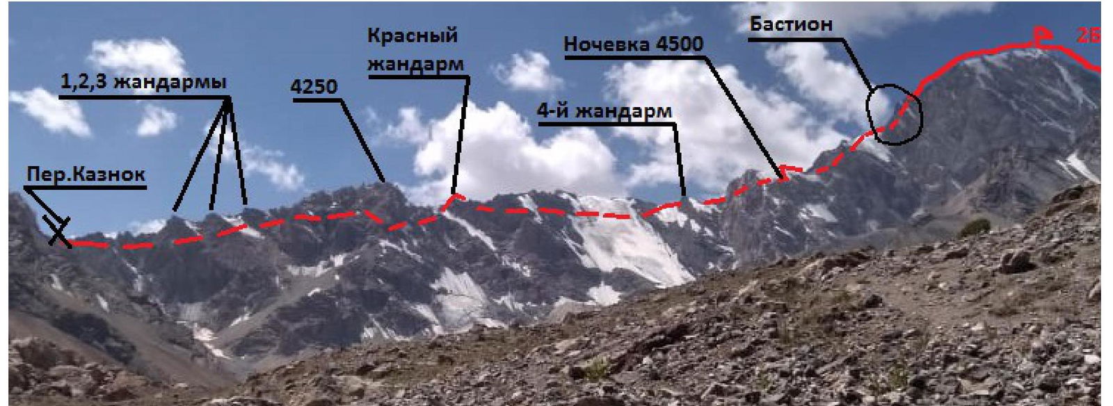
Red gendarme. Overnight stay at 4500 m. The Bastion
Route in UIAA symbols
Approach description.
From the "Vertical-Alaudin" alpine camp (the one with cabins), one needs to follow the main trail, which goes past a chaikhana and a large lake, without turning anywhere. At all intersections, go straight up, orienting yourself by the Fagi Tor mountain — it's visible from the trail almost everywhere. The Muddy Lakes are at its foot. Getting lost is almost impossible.
The path from the Muddy Lakes is of interest. You need to go down towards the Fagi Tor mountain; the trail goes along scree slopes. After passing one ascent at the level of a large red rock, the trail transitions to a moraine and continues upwards towards the Gratulet mountain. Here, you need to traverse without gaining altitude along a faintly visible trail (stone cairns, essentially jumping from rock to rock) to the median moraine.
There are:
- flat platforms for a tent,
- a stream runs (it's audible),
- a flat trail leads to the glacier under the Mazalat Pass.
You don't need to go onto the glacier itself. Follow the trail, sticking to the rocky ridge, which seems to block the path to the right and has no gap, but actually has a passage, and you will enter the cirque of the Zmeyka mountain.
In this cirque, everything is icy, and there are 2 scree-filled gaps in the Zmeyka ridge (when looking at Energy):
- The lower, larger one is more gentle
- The upper one, which appears to be at a 90° angle, but is actually at 30°
We need to go to the upper one. Be careful! Rocks are thawing from the pass and whizzing by like bullets, not frequently but insidiously. Exit onto the pass via scree without any climbing. From the Zmeyka Pass, the Kaznok Pass and the start of the route on Energy are visible, along with the overnight stay. The path is obvious – down the scree (possibly snow) along the trail.
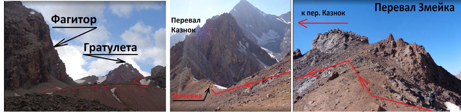
Zmeyka Pass
R0–R1 Start from the overnight stay on the Kaznok Pass 7:00. From the Kaznok Pass, follow simple rocks to the left of the ridge. Generally, 80% of the route is on the left side of the ridge. Below the ridge, there are places up to 100 m down.

Psychologically (we installed at least twice as many protection points as the first ascenders). The relief is not rich; there's a lot of space to fall — mainly narrow cracks for hooks and small elements. Sometimes at foot level. But there are always holds, as well as ledges for foot placement.
The logical path ends in a ledge failure, after which the ledge continues, but from this point, you need to climb a small wall above and, beyond the bend, there's not a ledge but a "highway" that narrows and ends in a rappel loop.
Descent vertically left (into the gully) leads to a scree saddle, from which you can descend by climbing, but you can also drop a rope. We rappelled.
R2–R3.
After two rappels, you reach scree all the way to the horizon near the 4th gendarme. You can go along the scree, bypassing all the undercuts and not ascending to the Red gendarme. We decided to ascend to the ridge to orient ourselves. The fact is that once you start bypassing the gendarmes, they disappear from view, and it's very hard to determine the height of 4250 m. But after it, there's a dip, which we wanted to find on the ridge.
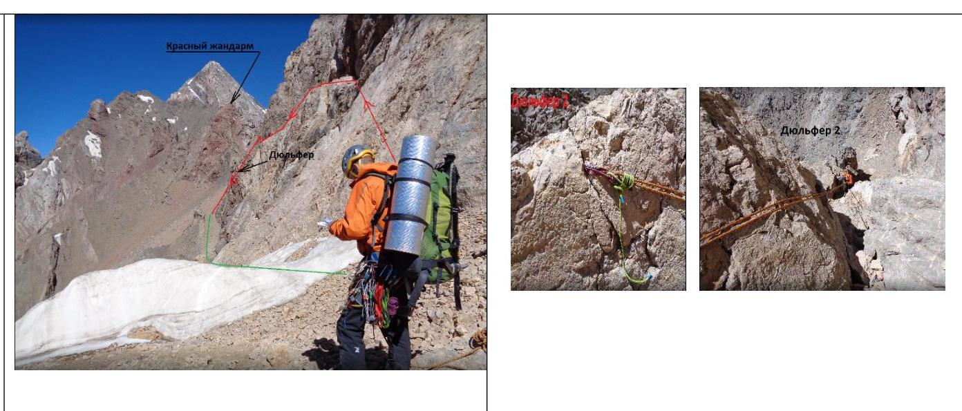
The dip is there, but it's not very obvious, and the Red gendarme, contrary to the first ascenders' photos, is higher than 4250 m (or appears so). The path to the gendarme is obvious:
- along the scree,
- via the simplest path,
- on foot, without climbing.
There's no cairn here. It remains below the ridge behind your back.
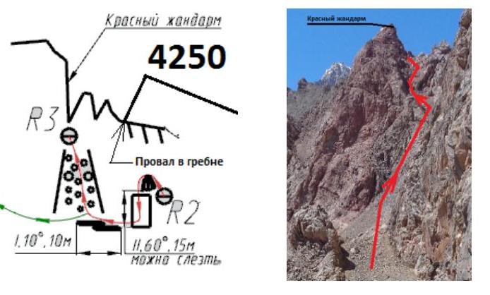
R3–R4
From the foot of the Red gendarme, climb upwards via small walls and ledges. Climbing is of medium difficulty — 5a–5b. The relief is initially not rich in protection — hooks. We left one "Kryukonogi" hook, rusty. From the top of the gendarme:
- left along ledges and simple rocks down,
- onto scree, heading under the 4th gendarme on the horizon.
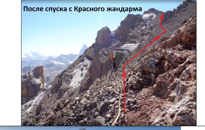
You don't have to climb the Red gendarme; there's a bypass lower down.
After descending from the Red gendarme
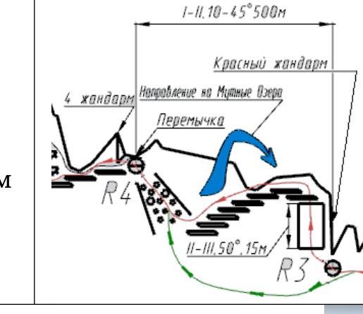
R4–R5. Overnight stay reached at 18:00.
From the saddle, the 4th gendarme is visible — it has a snowy mantle towards the summit. On the saddle, towards the Muddy Lakes, there's snow.
The path along the ridge with несложными undercuts:
- a small descent to the left (main route) side of the ridge,
- bypassing the 4th gendarme under the "ram's foreheads," between which there are ledges.
Climbing is only occasionally complex. There are holds, feet stand firmly, and there are places for protection.
In the middle of the "ram's foreheads," a couple of weak streams flow. You can fetch water. Not quickly, in small amounts, but it's water, not ice or snow.
After the "foreheads," return to the ridge along steep scree, leading to a saddle with platforms for a tent. It's hard to miss, and you won't want to.
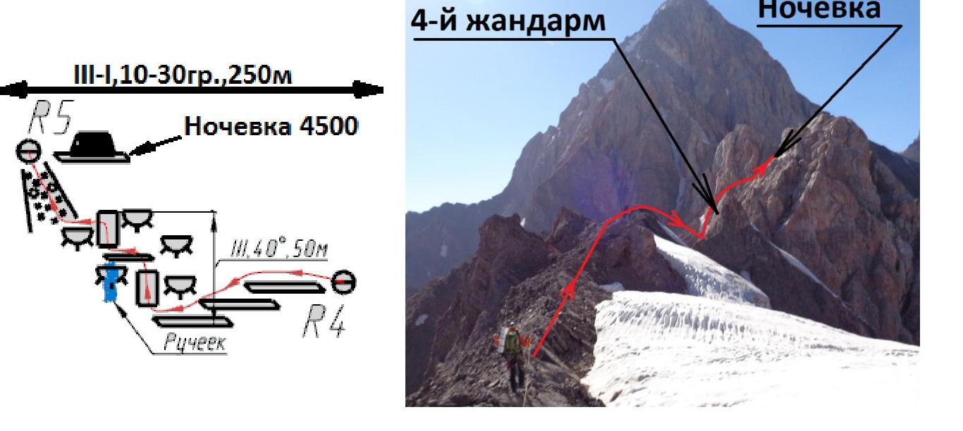
R5–R6. Start from the overnight stay at 7:00.
From the overnight stay along the ridge — simple climbing. The ridge leads to a large rock, to the right of which is a wide ridge, and to the left is a narrow section with a crack and small ledges for foot placement. It looks like a drop to the bottom.
We bypass the large rock on the left, through the crack and the drop. After 3–5 meters of careful movement, traversing the rock with protection in the crack, good wide ledges for foot placement with holds and places for protection appear. The ledges lead to a "field" — a place for an overnight stay with a snow patch. We pressed to the right — towards the ridge. A large snowy couloir remained on the left.
The ledges will end:
- in a 4–5 m snowy-icy couloir, requiring an ice axe, possible ice on the rocks;
- a steep rocky wall 3–4 m, 5B–5C;
- then, on the right side of the ridge, a rope length of difficult climbing ≈ 50 m, 5C+–6A. Relief under hooks and small protection elements. Holds are small but active and hold well. If you're not afraid, the climbing is pleasant. Local hooks are encountered.
After the rope length of climbing:
- left for 3–4 m;
- then, in a spiral from left to right and straight up onto the ridge;
- climbing is not complex but tense, 20 m.
Exit under a snowy ridge — 30 m of steep snow slope 45–55°, no protection. We ascended, pressing towards the exit of rocks on the left. Then, along rocky outcrops to the right under a large rock.
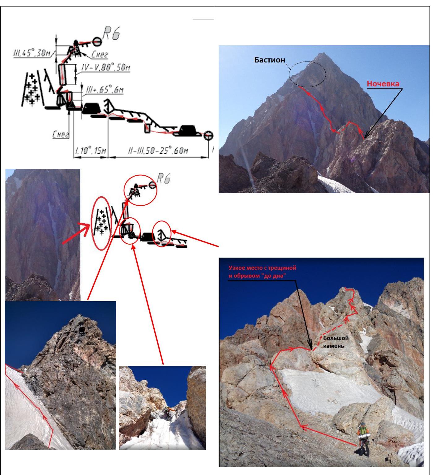
R6–R7. The Bastion.
The key section of the route. From the snowy ridge, follow a system of ledges between the "ram's foreheads" on foot, via the simplest path, under the base of a wide chimney filled with rocks. From the base of the chimney, left in a spiral through a 3 m wall to the edge of the ridge. There's an overhanging inner corner 4 m (key, mentioned in the first ascenders' description). After it:
-
a small traverse left;
-
then, from left to right upwards along a slab about 30 m, 5C–6A.
- There are holds;
- there are places for protection.
Then, the ridge begins, but it's not simple:
- holding onto the relief;
- climbing is 5A–5B in places;
- follow the simplest path to the ridge on the horizon;
- R7–R8.
R7–R8. Summit reached at 16:40.
Follow the ridge towards the summit:
- initially, there will be serious undercuts; it's not easy to proceed;
- the first 2 gendarmes were climbed directly with traverses within 3–4 m via the simplest path;
- then the ridge becomes more gentle, and climbing ceases until the summit;
- there's snow in places;
- the 3rd gendarme is bypassed on the left;
- there's a place for a tent on the summit.

Descent. 2B to the pass between Energy and Chimtarga. Started at 17:00. Below the pass on the trail — 19:00.
-
From the summit, head towards Chimtarga;
-
underfoot, scree with a trodden trail will appear;
-
on the first significant rock, a rappel loop will appear;
-
if facing the summit of Energy, rappel, shifting left towards the rock outcrops — there are loops;
-
if making a belay, it can be vertical;
-
2 full 60 m rappels to the flattening section, where crampons are removed, and it's walked on foot;
-
a descent in 3 pitches with simultaneous:
- 1 rope — facing the slope;
- 2 rope (60 m) — can be carefully done with back to the slope;
-
from the pass, a trodden trail leads to the overnight stays on the Muddy Lakes;
-
when it dips into a large scree moraine — landmark: stone cairns;
-
descent not in 1.5 hours, as in the first ascenders' description, but all 3 hours;
-
in the dark — 4–5 hours;
-
it makes sense to overnight under the pass:
- many platforms for overnight stay;
- water is present.
Appendix
R0–R1. Start from the overnight stay — 7:00.
From the Kaznok Pass, follow simple rocks to the left of the ridge. Generally, 80% of the route is on the left side of the ridge. Below the ridge, there are places up to 100 m down.
R1–R2. At station R2 — 11:00.
Start from a clear platform for a tent. Traverse along ledges, sometimes quite narrow, along the "ram's foreheads." Climbing is technically not complex. The relief is not rich; there's a lot of space to fall — mainly narrow cracks for hooks and small elements.
The logical path ends in a ledge failure, after which the ledge continues. From this point, you need to:
- climb a small wall above;
- beyond the bend, there's not a ledge but a "highway" that narrows and ends in a rappel loop.
Descent:
- vertically left (into the gully) onto a scree saddle;
- from which you can descend by climbing.
R2–R3.
Along scree under the Red gendarme. On foot, without climbing. The 4250 m mark and the dip with a cairn remain behind your back.
R3–R4
From the foot of the Red gendarme:
- climb upwards via small walls and ledges;
- climbing is of medium difficulty — 5a–5b;
- the relief is initially not rich in hooks.
From the top of the gendarme, left along ledges and simple rocks down, onto
R4–R5. Overnight stay reached at 18:00.
From the saddle, the 4th gendarme is visible — it has a snowy mantle towards the summit. The path along the ridge with несложными undercuts, then to the left side of the ridge, bypassing the 4th gendarme under the "ram's foreheads," between which there are ledges. Climbing is only occasionally complex. There are holds, feet stand firmly, and there are places for protection.
In the middle of the "ram's foreheads":
- a couple of weak streams flow.
After the "foreheads," return to the ridge along steep scree, leading to a saddle with platforms for a tent.
R5–R6. Start from the overnight stay at 7:00.
From the overnight stay along the ridge. It leads to a large rock, to the right of which is a wide ridge, and to the left is a narrow section with a crack and small ledges for foot placement. Bypass the rock on the left,
through the crack and the drop. After 3–5 meters of careful movement, traversing the rock, good wide ledges for foot placement, holds, and places for protection appear. The ledges lead to a "field" — a place for an overnight stay with a snow patch. Press to the right — towards the ridge. A large snowy couloir remains on the left.
The ledges will end:
- in a 4–5 m snowy-icy couloir (requiring an ice axe, possible ice on the rocks);
- a steep rocky wall 3–4 m, 5B–5C;
- a section on the right side of the ridge, left upwards — a rope length of difficult climbing ≈ 50 m, 5C+–6A (relief under hooks and small protection elements, local hooks are encountered).
Then:
- left for 3–4 m;
- in a spiral from left to right and straight up onto the ridge.
Exit:
- 30 m of steep snow slope 45–55° (no protection) — ascend, pressing towards the exit of rocks on the left;
- then along rocky outcrops to the right under a large rock.
R6–R7. The Bastion.
The key section of the route. From the snowy ridge, follow a system of ledges between the "ram's foreheads" on foot, via the simplest path, under the base of a wide chimney filled with rocks. From the base of the chimney, left in a spiral through a 3 m wall to the edge of the ridge. There's an overhanging inner corner 4 m (key, mentioned in the first ascenders' description). After it, a small traverse left and then from left to right upwards along a slab about 30 m, 5C–6A. There are holds; there are places for protection.
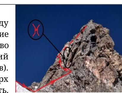
Then, the ridge begins, but it's not simple — climbing is at the level of 5A–5B. Follow the simplest path to the ridge. Scree, heading under the 4th gendarme on the horizon. You don't have to climb the Red gendarme; there's a bypass lower down.
R7–R8. Summit reached at 16:40.
Follow the ridge towards the summit. Initially, there will be serious undercuts. The first 2 gendarmes were climbed directly with traverses within 3–4 m via the simplest path. Then the ridge becomes more gentle, and climbing ceases until the summit. There's snow in places. The 3rd gendarme is bypassed on the left.
There's a place for a tent on the summit, with snow.
Descent:
- from the summit, head towards Chimtarga; underfoot, scree with a trodden trail will appear;
- on the first significant rock, a rappel loop will appear;
- if facing the summit of Energy, rappel, shifting left towards the rock outcrops — there are loops;
- if making a belay, it can be vertical;
- 2 full 60 m rappels to the flattening section.
- Then on foot.