I. CLASS OF ASCENT
- high-altitude technical
- AREA OF ASCENT
- Pamir-Alay.
-
PEAK, ITS HEIGHT, ASCENT ROUTE: Chimtarga, 5496 m, via the right part of the southern face.
-
PROPOSED DIFFICULTY CATEGORY — 5B cat. diff.
-
CHARACTERISTICS OF THE ROUTE: Height difference of the wall section — 650 m, — — — ridge — 250 m, Length of 6B cat. diff. sections — 320 m, — — — 5B cat. diff. sections — 255 m, — — — 3–4 cat. diff. sections — 575 m. Average steepness of the wall — 80°.
-
NUMBER OF PITONS DRIVEN:
- for belaying, for ITO.
- rock pitons — 243
- bolt pitons — 2
-
NUMBER OF CLIMBING HOURS — 47 h.
-
NUMBER OF NIGHTS SPENT AND THEIR CHARACTERISTICS: 2 — semi-reclining, 1 — reclining.
-
SURNAME, FIRST NAME, PATRONYMIC OF THE LEADER, PARTICIPANTS, AND THEIR QUALIFICATIONS: Stadnik Vladimir Fedorovich — Master of Sports of the USSR, Sedov Vladimir Ivanovich — Candidate Master of Sports, Grebennikov Alexander Andreevich — Candidate Master of Sports, Kabatscky Vladimir Ivanovich — Candidate Master of Sports, Pastukh Viktor Ivanovich — Candidate Master of Sports, Zhitniy Evgeny Vasilyevich — Candidate Master of Sports.
-
TEAM COACH — Stadnik V.F. Master of Sports of the USSR.
-
DATE OF DEPARTURE ON THE ROUTE — July 29, 1983 DATE OF RETURN — August 1, 1983
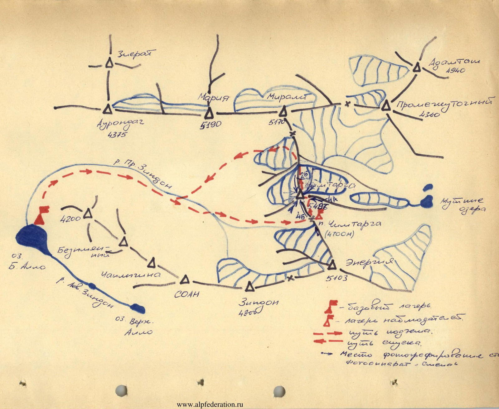
I. Geographical characteristics of the area.
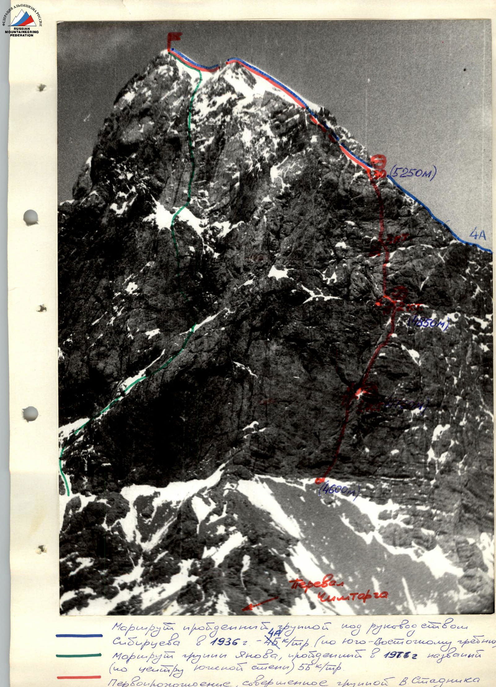
Chimtarga (5496 m) is the highest peak of the Fan Mountains, located in the middle of a short meridional segment connecting the western part of the Main Fan Ridge with the central and eastern parts.
The eastern slopes of the peak, descending into the Chapdar River valley to the Mутные ozera (Muddy Lakes), are not steep. To the west, Chimtarga, on the contrary, drops with sheer rock and ice walls. Its southern wall rises to the right of the Chimtarga Pass and is facing the northern slopes of Energia Peak. The western and southwestern walls drop into the Pravy Zindon gorge. On the opposite side of the gorge, they are faced by:
- the northern
- northeastern walls of two interesting peaks of the Pravy Zindon cirque — Zindon Peak and SOAN Peak.
Distinctive features of the climatic conditions of the Zindon River gorge area compared to other areas of the Fan Mountains are the dry climate. Therefore, on many routes, there is a shortage of water, which complicates the climbing conditions.
- Sports characteristics of the object of ascent.
The first climbers to appear in the Pravy Zindon gorge were the well-known enthusiast-researchers V.F. Gusev and A.S. Mukhin, who climbed Chimtarga in 1937 via the easiest route from the north (now the 2B cat. diff. route). And the first ascent to the summit was made in August 1936 by a group of topographers led by Sibirtsev. They followed the southeastern rocky ridge, later rated as 4B cat. diff.
For a long time, the Zindon River gorge was practically not visited by mountaineering expeditions. Only in 1967, an expedition from Novosibirsk made a significant contribution to the development of the area; previously unnamed peaks were named, and a number of interesting routes were climbed and classified. The greatest success of this expedition was considered to be the route via the SE wall of Chimtarga, classified as 5B cat. diff. and ranked 4th in the high-altitude technical class in the USSR championship.
In 1976, a group led by Yanov (Krasnoyarsk) made a first ascent, called "via the center of the S wall" (5B cat. diff.). In fact, this route passes through the center of the SW wall; the S wall of the peak remained unconquered. Our team decided to solve the problem of the S wall.
Preliminary preparation.
The physical and technical preparation of the climbers was based on joint year-round training in Kiev and the mountains. Training was conducted four times a week at the "Temp" sports complex and rock laboratories in Deneshy village and quarries.
During general physical training, the main focus was on developing the endurance of the climbers (long-distance running up to 20–25 km, cross-country skiing), as well as endurance for dynamic and static loads (pull-ups, push-ups, weightlifting, football, and basketball).
In the rock laboratories, in addition to individual climbing, the team practiced working with a rope, techniques for overcoming complex rock sections and cornices, and climbing with a backpack on belay. Particular attention was paid to:
- tactics for passing sections,
- group interaction,
- testing specialized equipment,
- organizing a bivouac on a sheer wall.
In 1982, Stadnik V., Grebennikov A., and Pastukh V. made a second ascent of Yarydag Peak via the center of the NW wall. In 1983, during a training cycle, the team made joint ascents:
- 3A cat. diff.
- 4B cat. diff.
- 5B cat. diff.
Before ascending Chimtarga, the team observed its S wall, clarified the ascent route, possible bivouac locations, and tactics for passing the route.
Tactical plan for the ascent. July 27–28 — approach to Chimtarga Pass, observation of the route. The ascent was planned to start on July 29. The route was planned to be completed in 4 days:
- 1st day — approach to the wall and passage of the lower belt of the wall (section R0–R7).
- 2nd day — passage of the middle part of the wall (section R7–R16).
- 3rd day — passage of the upper belt, exit to the SE ridge.
- 4th day — ascent to the summit and descent.
- 5th day — reserve day.
Considering the steepness of the wall and the potential risk of rockfall or icefall from its upper part, the planned bivouac locations were chosen in objectively safe places under overhangs. To ensure safety on the route, the first climber used a double rope, worked without a backpack in galoshes. In case of a fall, an absorber with a breaking force of 400 kg was used.
The rest of the team climbed using double ropes or with top-rope belay. Backpacks were lifted by the climbers on their shoulders or attached to their harnesses via an extender. When choosing the amount of main rope, pitons, and carabiners, the possibility of processing the route above the bivouac locations was taken into account.
In case of an emergency, the group would descend via the ascent route. For this, they were equipped with the necessary number of rappel slings and pitons. During the group's stay on the wall, visual observation was planned using binoculars by two observers located on Chimtarga Pass. Radio communication between the climbers and the base camp was maintained using "Vitalka" radios.
The adopted tactical plan was executed and fully justified on the route.
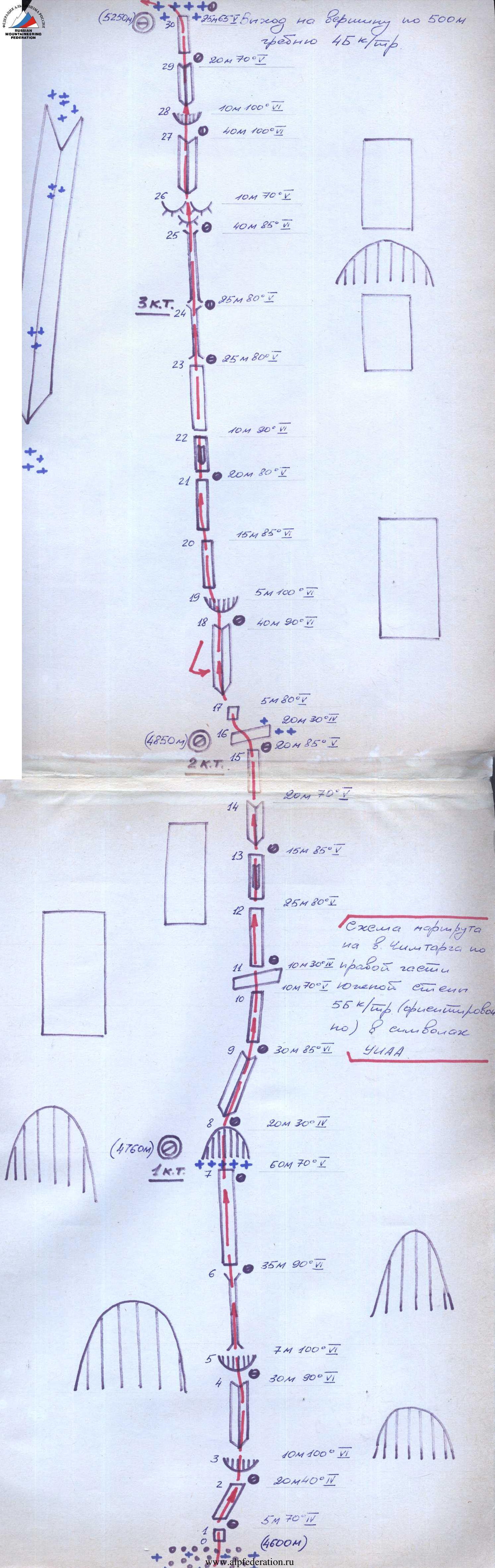
Order of passage on the route. July 29: The group started the ascent at 6:00. The previous day, from Chimtarga Pass and directly from under the wall, the team observed the route, clarified possible bivouac locations, and planned the movement schedule. The main part of the route in the lower section of the wall follows a nearly vertical fissure, ending after 170 m at a large niche under a huge cornice. The approach to the fissure starts 30 m to the left:
- first, through a vertical wall (5 m, 70°),
- then traversing right along an inclined ledge 20 m (section R0–R1),
- to the first cornice (section R2–R3), which is passed using ladders, with piton belay.
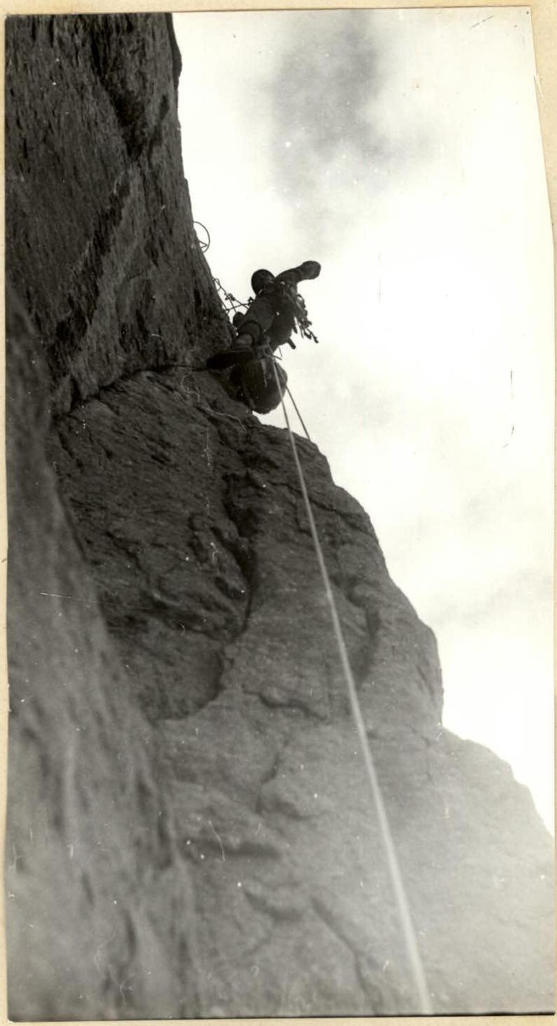
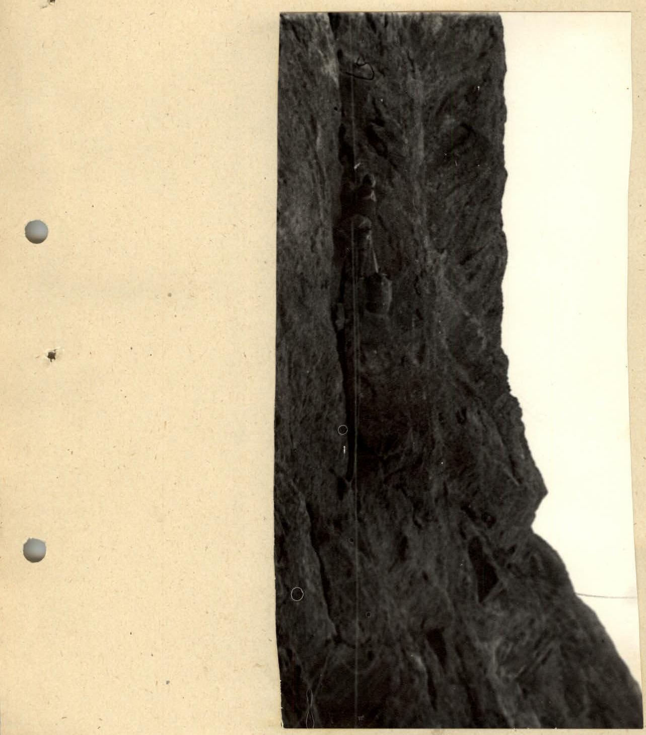
The first team to start was Stadnik–Zhitniy. After the cornice, a fissure begins, going slightly left and up — the second belay point. The first sections of the route required the climbers to use all their skills and a wide range of rock climbing equipment. The rocks are monolithic. Boxes, wedges, and chocks were used.
After 30 m of complex climbing, the fissure leads to a second, more powerful cornice (section R3–R4), under which a hanging belay station is set up. The cornice is passed with very complex climbing using ITO. After the cornice, another vertical fissure follows, slanting to the right. Passing this fissure is complicated due to the lack of holds on the smooth wall (section R5–R6).
After 30 m, the fissure is interrupted by a smooth, overhanging rock. Under it, the route goes right 6 m and continues into the fissure, turning into a chimney and then a large niche where the first bivouac is planned.
The niche is protected on the left by a huge cornice, which is cut through by a groove filled with ice on the right side. Nearby and higher up on the wall, there are no suitable places for a comfortable bivouac. The team decides:
- to organize a sitting bivouac for 4 people under the cornice,
- and a pair will squeeze onto a small ledge under an overhang to the right of the niche.
While the rest of the team approaches the niche and prepares the bivouac, the lead pair continues processing the route. For safety, they move slightly to the right of the niche. In the lower part of the rock, sections are iced over. The rocks are steep, smooth, with few cracks and holds. Climbing is very challenging. The direction of movement needs to be continuously changed. After 20 m, the fissures disappear altogether, and to ensure belaying, a bolt piton has to be driven. This section (R8–R9, 80–85°, 40 m) ends with an exit to a band of light-colored rocks under a long cornice. Here, the first day's work ends, and the pair descends to the niche for a bivouac at 20:00.
July 30. The first to start working at 7:00 is the Grebennikov–Stadnik team. From the end of the previous day's belay, along steep, smooth rocks, a complex traverse 30 m to the right to a stream. The rocks are partially iced, which significantly complicates the work. Further right and up 60 m (70–75°) of complex climbing leads to the apex of a triangle visible from Chimtarga Pass. From the triangle's apex, 15 m straight up (90°) to a and a small ledge. There are still very few cracks, and the section is climbed using small holds and friction.
Traverse left along the ledge 10 m and exit to a niche convenient for a bivouac.
From the niche, traverse left another 15 m and exit to the left part of a huge hollow in the wall. 10 m up a vertical wall with an overhang to a small ledge. Then the rocks are smooth, without cracks, and to organize belaying, a second bolt piton is driven. From the ledge under the overhang, right and very complex climbing with ITO leads under a cave. To the right of the cave:
- climb up 3–4 m along a vertical wall using ladders;
- then a smooth wall follows, covered from above by a cornice. Therefore, a pendulum move is made from the cave level to the right (5 m) under an overhanging rock in the shape of a "nose". Here, there are cracks for pitons, and using ladders, Stadnik V. overcomes this section and exits to a small inclined ledge.
The first to continue working is Pastukh V. Through a small cornice...
Table of main route characteristics
| Date | Section | Average steepness, ° | Length, m | Type of relief | Difficulty | Condition | Weather conditions | Number of pitons driven (rock) |
|---|---|---|---|---|---|---|---|---|
| 29.07. | R0–R1 | 70 | 5 | wall | 4 | good | 1 | |
| R1–R2 | 40 | 20 | slope | 4 | - " - | 1 | ||
| R2–R3 | 100 | 10 | cornice | 6 | - " - | 5 | ||
| R3–R4 | 90 | 30 | internal angle | 6 | - " - | 11 | ||
| R4–R5 | 100 | 7 | cornice | 6 | - " - | 10 | ||
| R5–R6 | 90 | 35 | chimney | 6 | - " - | 12 | ||
| R6–R7 | 70 | 60 | wall, traverse to internal angle | |||||
| 30.07. | R7–R8 | 30 | 20 | collapsed niche | 4 | ice | - " - | 2 |
| R8–R9 | 85 | 30 | groove | 6 | iced | - " - | 8 | |
| R9–R10 | 70 | 10 | wall | 5 | iced | - " - | 3 | |
| R10–R11 | 30 | 10 | inclined ledge | 4 | iced | - " - | 1 | |
| R11–R12 | 80 | 25 | wall | 5 | iced | - " - | 8 | |
| R12–R13 | 85 | 15 | wall with internal angle | 5 | iced | - " - | 6 | |
| R13–R14 | 70 | 20 | internal angle | 5 | - " - | 5 | ||
| R14–R15 | 85 | 20 | wall | 5 | - " - | 6 | ||
| 31.07. | R15–R16 | 30 | 20 | inclined ledge | 4 | iced | - " - | 6 |
| R16–R17 | 80 | 5 | wall | 5 | iced | - " - | 3 | |
| R17–R18 | 90 | 40 | internal angle | 6 | - " - | 20 | ||
| R18–R19 | 100 | 5 | cornice | 6 | - " - | 8 | ||
| R19–R20 | 85 | 15 | wall | 6 | - " - | 7 | ||
| R20–R21 | 80 | 20 | wall | 5 | - " - | 10 | ||
| R21–R22 | 90 | 10 | wall with internal angle | 6 | iced | - " - | 8 | |
| R22–R23 | 80 | 25 | wall | 5 | - " - | 8 | ||
| R23–R24 | 85 | 25 | chimney | 6 | - " - | 10 | ||
| R24–R25 | 85 | 40 | chimney | 6 | - " - | 15 | ||
| R25–R26 | 70 | 10 | barrel foreheads | 5 | - " - | 6 | ||
| 01.08. | R26–R27 | 100 | 40 | overhanging internal angle | 6 | good | 25 | |
| R27–R28 | 100 | 40 | cornice | 6 | - " - | 10 | ||
| R28–R29 | 70 | 20 | internal angle | 5 | - " - | 7 | ||
| R29–R30 | 65 | 25 | wall | 5 | - " - | 6 |
Ascent to the summit via the 500-meter SE ridge, 4B cat. diff.
Conclusion and recommendation for the route.
The route climbed on Chimtarga Peak via the right part of the S wall is technically very complex and mixed. According to the participants, the climbed route (wall section) is comparable in difficulty to the previously climbed route on Yarydag Peak via the center of the NW wall, 5B cat. diff. The route corresponds to the most challenging ascents of 5B cat. diff., and the need to pass several overhangs and cornices brings it closer to 6 cat. diff. routes.
The route has the following features:
- A significant part of the route has a steepness of 80°, and some sections — 90° or more.
- The rocks along the entire route are quite monolithic, except for section R23–R24.
- The nature of the rocks is diverse, but internal angles and chimneys prevail.
- Belaying on most sections was mainly done with pitons (wedges, boxes) and chocks; bolt pitons were also used.
- The steepness of the route requires participants to have excellent physical and technical preparation.
- The number of bivouac sites on the route is limited.
- Rockfall was not observed on the route. Ice often falls from icicles but passes to the left of the route.
- The route can be recommended for passage only to well-prepared groups with good equipment.
The bottom (1 m) and steep, smooth rocks lead to the base of a hollow filled with ice and snow. Via the right part of the hollow through an internal angle (19 m, 90°) with ice, exit to an inclined wall of the second hollow with snow. From the hollow to the left, very steep and previously unexplored rocks are climbed (25 m, 80–85°). This section is overcome with great difficulty, and organizing reliable belaying is very challenging. Further exit under a huge chip in the form of a vertical "cucumber". Up the internal angle between the chip and the wall, climb 25 m into the expanded part of the internal angle. The exit to the "cucumber" is very complex because the chimney is closed by a cornice, and a detour to the left or right is impossible due to the steepness of the rocks and the lack of holds. At the top of the "cucumber", there is a small ledge where the whole group can gather under an overhang. A station is set up, and the Pastukh–Stadnik team rappels down to the niche for a bivouac, where a tent is already set up and dinner is prepared.
July 31. The first to continue working is the Pastukh–Sedov team. The task is to work on one of the most complex sections of the route — the upper belt of light-colored rocks overhanging for 40–50 m. From the top of the "cucumber", 3 m to the right, along a vertical, smoothed internal angle, 40 m up to a small niche where a safe hanging belay station can be set up. From here, an overhanging wall begins, cut through by an internal angle with a fissure. The inclination of the fissure to the left further complicates its passage, as it requires working mainly with the hands. Passing the fissure requires excellent rock climbing skills. For belaying, boxes, wedges, and large chocks work well.
After 40 m, the fissure is closed by a large cornice, under which the next hanging belay station is set up. The cornice (section R27–R28) is passed on the right via a small fissure (ITO). Then, exit to the wall (70°) and along it, 50 m of complex climbing to the SE ridge of Chimtarga Peak. This marks the end of the technically complex part of the route. The group gathered on the ridge at 18:00 and, having moved 150 m to a convenient spot, stopped for a bivouac.
August 1. At 8:00, the group continued moving along the ridge and at 13:00 reached the highest point of the Fan Mountains — Chimtarga Peak 5489 m. Descent via the N ridge (2B cat. diff. route).
Passage of section 3–4