
International Alpine Tourist Center "Vertical-Alaudin"
Chapdara - Bodkhona, 5B, traverse (V. Ashanin's route, 68)
Report
on the first ascent of the Chapdara - Bodkhona traverse with ascent to Chapdara via the north ridge and descent from Bodkhona to the Bodkhona saddle, Fan Mountains, Pamir-Alay
Chapdara Peak. North Ridge
2005–06 MATC "Vertical-Alaudin" All Rights Reserved
Ascent to Chapdara Peak (5197 m) via the north ridge
To accomplish our planned traverse of Chapdara-Bodkhona peaks with ascent via the north ridge of Chapdara peak, first climbed by a group from the Kazakh Alpine Club led by U.U. Usenov in 1966, and classified as a 5B category route, we left the base camp at Tepe meadow on August 5, 1966, with a full set of equipment and provisions, and by evening of the same day, we reached Alaudin Lakes via Kaznok Pass.
Our group was accompanied by another group from our alpinade, consisting of 4 people led by R. Persiyantsev, who crossed Kaznok Pass. They intended to ascend Chimtarga peak via a 5A category route and, after descending, would observe and maintain communication with our group.
The traverse plan included reconnaissance of the route in the area of Chapdara and Bodkhona saddles, as well as food caching. Therefore, we decided to leave half of our provisions at the moraine near the entrance to the South Bodkhona glacier valley and descended to Alaudin Lakes with the entire group. In the evening, it was decided that two groups would go for reconnaissance and food caching:
- The first group - Statsky and Yastrebov - to Chapdara saddle
- The second group - Leontiev and Tselovakhin - to Bodkhona saddle
The task of the second group, apart from reconnaissance of the descent route from Bodkhona peak, included assessing the feasibility, difficulty, and overall possibility of traversing the ridge towards Black Peak and Zamok Peak, as this final segment of our route was a mystery to us despite numerous consultations. Both groups successfully completed their tasks.
Now we had a clear overall understanding of the route, especially after the remaining team members consulted with the alpinade leaders and Kazakh Alpine Club members who were based at the lakes.
Reconnaissance results:
I group:
- The descent from Chapdara should not be very difficult. There is a real possibility of descending from Chapdara peak to the saddle in one day;
- The most challenging part of the ridge between Chapdara and Bodkhona peaks will be the ascent to the intermediate peak between the main peaks. It features an approximately 600-meter, nearly vertical wall before reaching the upper part of the ridge.
II group:
- The descent from Bodkhona peak to the saddle is quite possible, although technically challenging. According to available information, Alma-Ata climbers who ascended via the western wall in 1967 did not dare to descend to the saddle, considering the lower part of the wall (about 400 m) to be a single overhanging section. Reconnaissance data indicates that this section is nearly vertical with individual overhangs not exceeding 40 m;
- The ascent from Bodkhona saddle through an unnamed rocky peak to the ridge between Black Peak and Zamok Peak, and especially the ridge itself, is not technically challenging and is not interesting from a sporting perspective.
The next day, August 7, at 15:00, the camp at Alaudin Lakes was dismantled, and the group headed towards Tolobas Pass, where we spent the last night before the summit push.
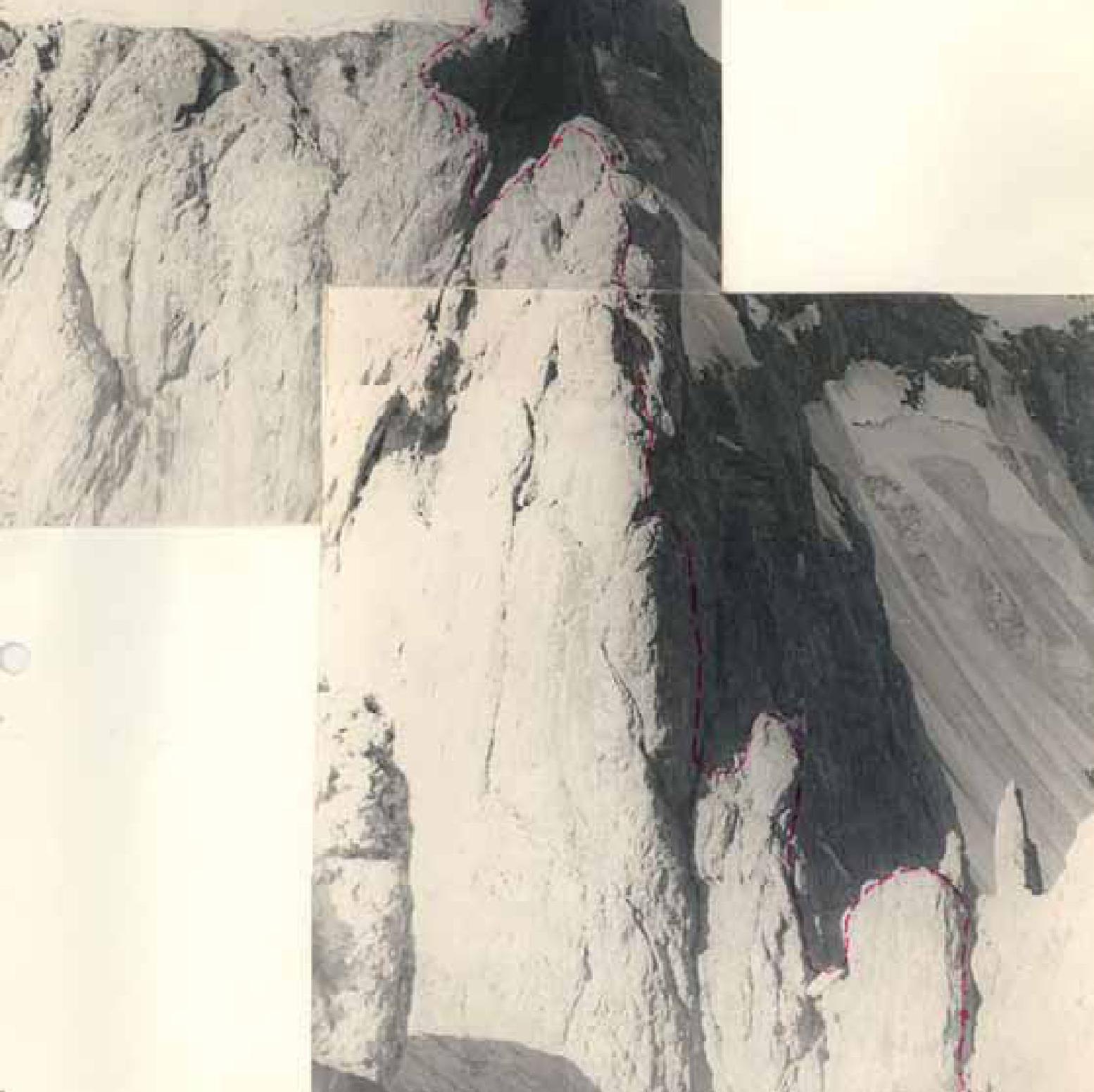
August 8. We started the route at 6:00 from the initial bivouac. Initially, the path follows the ridge, which is heavily destroyed with several "gendarmerie" of small height. All "gendarmerie" are bypassed on the left via easy rocks and scree. Most of the path goes through medium-steep scree, occasionally steep. At a plateau where the start of the route becomes visible, we rope up as the further path seems quite challenging. The ascent from the bivouac to the plateau is no more than 200 m (1 hour).
Section R0–R1. The route follows rocks of medium difficulty at 45–55°, with occasional small, 2–4 m high walls. The ascent is 150 m towards a visible snow patch on the left side of the ridge. We reach this snow patch. Its steepness is 35–45°. The ascent is 30 m. Belay is through an ice axe and rock outcrops.
Section R1–R2. At the top of the snow patch, we exit onto rocks. Initially, we ascend via a wide internal angle "en face," then via a wall, veering slightly left. The wall ends at an inclined ledge. The first control cairn is on this ledge. The steepness of this section is 70–80°, with a 90° section (1.5 m total) in the middle part of the internal angle. The ascent is 60 m, with difficult rocks and 6 pitons driven. At this point, it's crucial to avoid the temptation to follow the seemingly easier rocks of the couloir visible from the ledge on the right. This couloir is very dangerous due to rockfall.
Section R2–R3. From the ledge (its left part), the route goes straight up a wall at 80° with an ascent of 80 m to another, smaller ledge.
Rocks are:
- difficult;
- местами средней трудности.
Features of the section:
- a very large number of loose rocks that can be dislodged by a rope;
- maximum attention is required while traversing this section;
- movement with backpacks is very difficult, so they are pulled up on a rope;
- piton belay, 9 pitons;
- crampons are not to be worn.
Section R3–R4. From the ledge, the route follows an internal angle at 60°. The ascent is 30 m.
The internal angle turns into a wet crack 20 m long and 40–50° steep. Piton belay, 3 pitons. This area also has many loose rocks.
From the crack, we exit to a chimney at 70–80°, with an ascent of 30 m, rocks of medium difficulty, 2 pitons.
Section R4–R5. From the chimney, we exit to a ledge, from which we ascend left upwards via rocks of medium difficulty, occasionally difficult, with an ascent of 80 m, at 65–75°, and reach a ridge, along which we move right upwards.
The ridge is a rocky section rising in steps. Rocks are mostly difficult, occasionally of medium difficulty. Total ascent is 150 m, with an average steepness of 75°. Caution is necessary due to many loose rocks. The orientation point is a red rocky tooth visible against the sky.
The ridge ends at an inclined slab at 45°, with an ascent of 15 m to a rocky section at 75–80°, rising in steps. The steps are inclined ledges that can serve as a bivouac site if needed. The ascent is 30 m, with piton and outcrop belay. 21 pitons are driven.
Section R5–R6. The rocky section transitions into an internal angle at 60–65°, with an ascent of 60 m. Rocks are difficult, 7 pitons driven. The internal angle is traversed with rappelling.
Section R6–R7. From the internal angle, we exit to a smooth wall 13–15 m high and 80–85° steep. Rocks are difficult, and movement with backpacks is very challenging. The first climber moves without a backpack. Piton belay, 5 pitons driven.
Section R7–R8. The direction is towards the upper part of the ridge, bypassing a red wall on the right. From below, this wall resembles a human face, and the described section begins under the "chin" of this face. Total ascent is 150 m. Steepness is 75–80°. The section is traversed via narrow ledges crossing the wall.
Passage through this section is very complex:
- At belay points, there is barely space for 2 people.
- Movement with backpacks is very difficult.
- Piton belay.
- In some places, ladders were hung to facilitate belaying.
- 20 pitons are driven.
Section R8–R9. We exit under an overhanging rock forming a small niche where two team members can barely fit. Standing with a backpack is impossible due to the niche's inclination and the backpacks getting stuck under the overhang, effectively being pushed downwards.
From the niche:
- 3 m back along a narrow ledge alongside a 3-meter vertical wall.
- A very challenging section.
- At the end of the ledge, where there's the most convenient exit to the wall, the wall's lowest part has a negative incline.
- However, ascending the wall is impossible without prior preparation.
- Ladders are hung.
- The ascent is 5 m.
- 3 pitons are driven.
- All climbers move without backpacks.
Above, the wall becomes less steep, not exceeding 70°, resembling a smooth slab with very few handholds.
It is traversed towards a horizontal crack, from which we exit left to a friend's ledge where one can sit with legs dangling - for no more than two climbers.
To reach the ledge, we traverse 40 m - a very challenging section:
- Belay is only piton.
- 6 pitons are driven.
Then, directly upwards via a wall at 85° with very small handholds:
- The wall is 40 m long.
- Belay is only piton.
- 5 pitons are driven.
Total ascent on this section is 85 m:
- 14 pitons are driven.
- Ladders were hung.
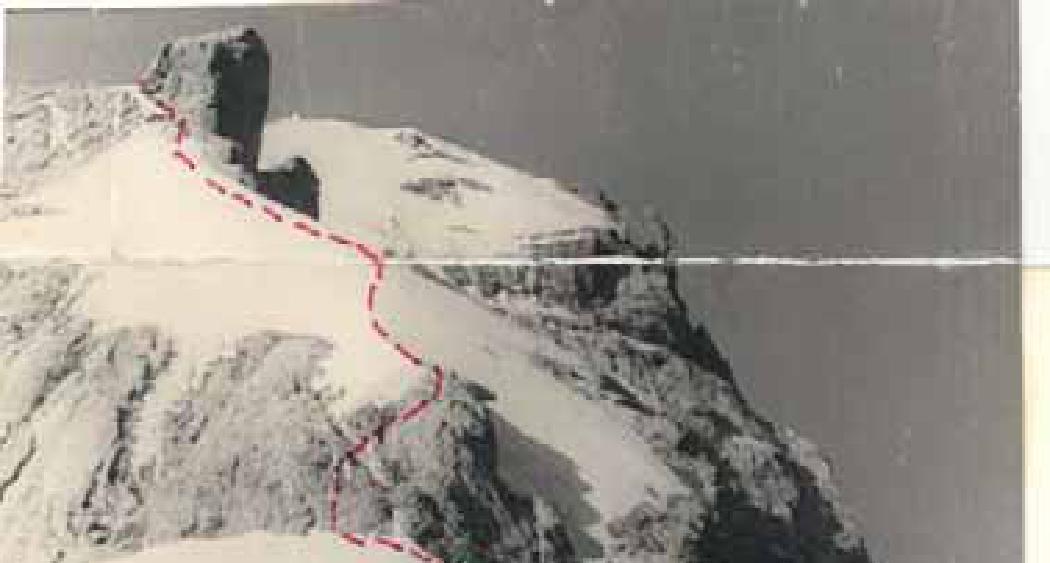
We exit to an inclined platform with a large stone on it. On one side of the stone, there's a small snow patch. At 19:00, we stopped for the night. We struggled to set up tents, or rather, we suspended them to have just a roof, stretching them with our bodies. We drove many pitons to organize night belays. Safety harnesses were not removed, and everyone was on self-belay. From Alaudin Lakes, this section appears as a ridge section with a cleanly cut-off top (like a table). On this flat section, two pointed pillars stand out. The view is quite peculiar.
II day. August 9.
We left the bivouac at 7:00 AM. The further path follows the ridge directly towards a well-visible pointed rocky tooth.
Section 9–10. Immediately from the bivouac site, we traverse 30 m along the ridge. The ridge is simple.
Further:
- We descend slightly right (the ridge turns somewhat right) for 30 m in a sporty manner to the base of a "gendarme." The latter is descended via climbing.
- Rocks are of medium difficulty, with belay via a piton at the bottom.
- The "gendarme" is bypassed on the left via 60 m without ascent or descent. Belay is through outcrops and pitons, with 4 pitons driven.
- Ascent via a 15-meter wall, 1 piton driven.
We exit to a small plateau on the ridge under the base of the rocky tooth visible from the bivouac.
Further:
- Descent down a not-too-difficult wall for 5 m, and we find ourselves in a depression on the ridge at the base of a wall 80–85° steep and 80 m high.
- Rocks are difficult, especially in the upper part of the wall where there are very few cracks.
- Backpacks are pulled up on a rope.
- Ladders are required to traverse the wall.
- Piton belay, 7 pitons driven.
At the top of the wall, there's a small (3–4 m) depression in the ridge. Via easy rocks, 30 m, we exit to the base of a snow-ice slope. A plateau.
Section R10–R11. The snow-ice slope is initially bypassed on the right via rocks of easy and medium difficulty along the right edge of the ridge for 60 m. Then, we exit to the base of a snow-ice cone. This location is very characteristic due to a very steep rocky couloir starting here and dropping to the south. Large icicles hang on the rocks as this spot is not heavily exposed to sunlight.
We ascend the snow-ice cone at 40–45°, with an ascent of 20 m. Steps are cut, and an ice axe piton is driven. The direction is towards rocks at the top of the cone. Rocks are heavily destroyed, very loose, and partly covered with rime. Steepness is 40–60°, of medium difficulty. We ascend via rocks initially straight up for 20 m, then right for 60 m towards a visible snow-ice ridge against the sky. 3 pitons are driven on this section. Simultaneously, we bypass another snow-ice "island" on the left. We exit to the ridge, almost bare ice. Sometimes, steps need to be cut, with a total ascent of about 60 m. Along the ice ridge, 200 m long and 35–40° steep, we move with alternating belay, sometimes simultaneously, towards a rocky ridge heavily indented. From below, it resembles a group of peculiar rocky "feathers." Via rocks of medium difficulty, 40 m, 1 piton, we exit to the "feathers," bypassing them on the left via rocks of medium difficulty for 60 m. Belay is through outcrops. Further, 70 m of simple, horizontal ridge follows. We exit under the base of the next "gendarme." This is a fairly large (at least 100 m long) rocky massif. We bypass it on the left:
- Initially on snow, higher up on ice at about 45° with an ascent of 50–60 m. 2 ice axe pitons are driven.
- Movement requires caution due to potential crevasses.
We exit to a wide snow plateau. A bivouac is possible here. Since we still have time, and the further path lies across snow slopes, the possibility of a bivouac higher up is evident, so we decide to continue the ascent. Initially, 50 m upwards along an almost flat shoulder, then sharply right under an ice cliff (completely safe) for 80 m. In the lower part of the cliff, steps are cut, and we exit to wide snow slopes. We veer left across snow fields at 30 to 45° towards a rocky shoulder, traversing 250–300 m. Here, there's a saddle - a wide snow area.
Since ascending snow-ice slopes in the late day is undesirable, we decide to bivouac, as we didn't want to spend the night on the summit. Time is compensated by an earlier start the next day. We set up bivouac at 17:30.
From this location, Bodkhona peak is clearly visible.
III day. August 10.
Section R11–R12. We depart at 6:30. Without crossing the bergschrund in its lower part, we move around steep snow-ice slopes. To do this, with a slight ascent of about 60 m, we move along the bergschrund (below it) to the right towards a rocky outcrop in the ridge. There, in a convenient spot, we cross the bergschrund via bridges and begin ascending "en face" up the ice slope. Steepness is 30–45°, the slope is 100–150 m long, movement is on crampons. 2 ice axe pitons are driven. We exit to a pre-summit shoulder, along which, via small scree, 300–350 m, we reach the summit. The
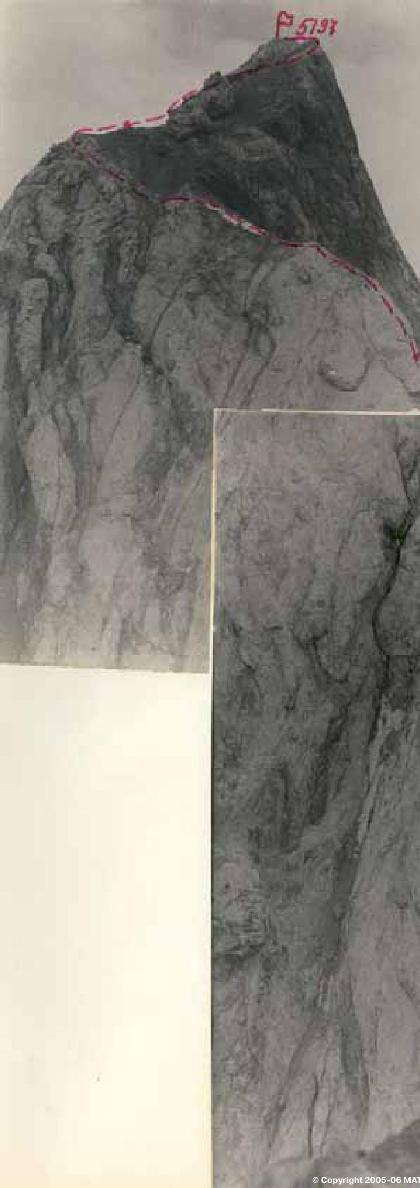
Descent from Chapdara to the saddle towards Malaya Chapdara peak (Section R12–R13)
The height from the shoulder to the summit is about 100 m, with a steepness of 20–40°, movement is simultaneous, and upon reaching the summit, it's with alternating belay.
The summit is a depression in the ridge (a rocky ridge) about 100 m long, heavily destroyed:
- it drops to the north with a steep ice slope
- and to the south with steep scree
We reached the summit at 9:00.
Section R12–R13. Descent from Chapdara peak. Initially, the descent follows a simple, heavily destroyed scree ridge for 5–6 rope lengths. Along the way, there are monolithic rock formations, heavily smoothed, short (3–4 m), which are traversed with alternating belay. Further, the ridge becomes steeper, about 45°. Rocks are like "ram's foreheads." Traversing is sporty for 40 m. Below, there's a section of simple rocks for 30–40 m, followed by a 15 m rappel down a wall with a negative incline. Below, a saddle in the ridge between Chapdara peak and a large "gendarme," which Alma-Ata climbers call Malaya Chapdara, is visible. Rocks leading to the saddle are heavily smoothed, 90 m long, at 65°. Movement is very cautious, descent is sporty, with almost no cracks for piton placement. 3 pitons. The section is complex. Malaya Chapdara rises about 80 m above the ridge. The route directly along the ridge "en face" does not appear to be the easiest option, so we decide to bypass it on the left.
Section R13–R14. Initially, we move along rocky ledges with a slight loss of height (20 m), then along a slope covered with rime and featuring rocks like stones thawed from ice. Steepness is 50°, the section is 150 m long. 3 ice axe pitons and 5 pitons are used.
We exit to the shoulder of Malaya Chapdara, which extends from it as a rocky ridge. Further bypass of Malaya Chapdara on the left is impossible due to walls dropping vertically.
Section R14–R15. We decide to ascend right upwards along the ridge towards a rocky couloir. Rocks are of medium difficulty, movement is alternating. Belay is through outcrops for 50 m, steepness is 40°. Further, directly upwards via the couloir for 40 m towards Malaya Chapdara peak, steepness is 50°, rocks are smoothed, with small holds, piton belay - 2 pitons. There are loose rocks, and the rocks are partly destroyed.
North Bodkhona
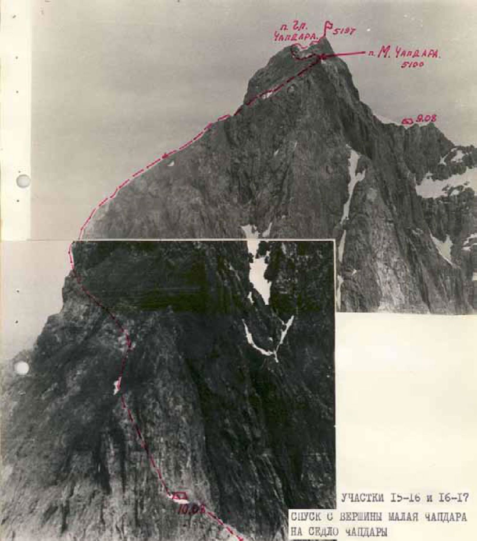
Sections R15–R16 and R16–R17. Descent from Malaya Chapdara peak to Chapdara saddle
We exit to the ridge of Malaya Chapdara, to a fairly spacious area, 3 × 5 m in size. On the way, there's a wall 10 m high, vertical at the bottom - negative. Climbing is extremely challenging, 4 pitons.
Then:
- Left upwards via rocks of medium difficulty
- Steepness is 45°
- Length is 40 m
We exit to Malaya Chapdara peak. Control cairn.
Section R15–R16. Descent from Malaya Chapdara along a very long, heavily destroyed ridge. Movement is simultaneous, with a height loss of about 500 m. Scree slopes in the form of large, wide ledges drop right into the valley. We turn left and move along the main ridge, which drops steeply towards Chapdara saddle. Repeated sporty descents via destroyed rocks at up to 75° steepness brought us to a short snow shoulder 100 m from Chapdara saddle. A nearly horizontal, destroyed ridge leads to the saddle, but due to the presence of water, we decide to stop for the night. Time is 18:00. Chapdara saddle is at 4200 m.
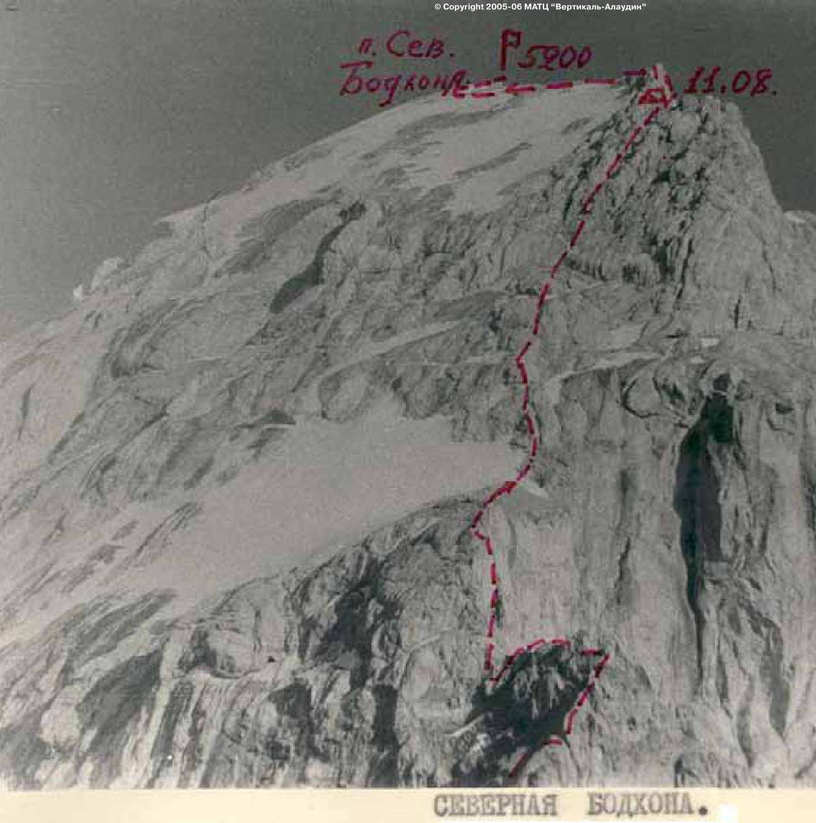
August 11.
On this day, we were to ascend via the northwest ridge of Bodkhona peak. Observations from the bivouac on Chapdara saddle in the evening made it clear that this section of the route would be very serious and demand all our strength. This part of the route is not so much a ridge as a fairly wide wall, steep and completely undestroyed, with smoothed rocks resembling "ram's foreheads." From the south, this wall drops very steeply.