- Climbing category — technical
- Climbing region — Pamir-Alai, Zeravshan Range, Alaudin valley
- Chapdara peak, 5050 m, NW wall (left route)
- Category of difficulty — 6B
- Height difference of the route — 1740 m. Length — 1960 m.
Length of sections with 5–6 category of difficulty — 1330 m. Average steepness of the main part of the route — 73° (3300–4930), including 6 category of difficulty:
- 75° (35 m)
- 80° (40 m)
- 90° (175 m)
- 95° (60 m)
- Pitons driven:
- Rock: 64, 18
- Bolt: 8+7*, 3
- Chocks: 216, 58
- Skyhooks: 16
- Ice screws: 7
* — reuse of previously driven pitons and skyhook holes
-
Team's total climbing hours — 40 and days — 5
-
Overnight stops: 1st — a platform was cut on a shelf with flowstone; 2nd — a platform on a talus shelf; 3rd — bivouac on diagonal shelves: three in a tent, three in a niche. All bivouacs were in a prone position.
-
Team leader: Mikhail Aleksandrovich Brook, Master of Sports
Team members:
- Sergey Viktorovich Borisov, Master of Sports
- Alexander Vladimirovich Volegov, Candidate for Master of Sports
- Alexander Petrovich Kolesov, Candidate for Master of Sports
- Valery Amirovich Manirov, Candidate for Master of Sports
- Salavat Zagitovich Khabibulin, Master of Sports
-
Coach: Sergey Borisovich Efimov, Honored Master of Sports.
-
Departure to the route — July 7, 1990 Summit — July 12, 1990 Return — July 12, 1990
-
Organization: Sverdlovsk Regional Sports Committee
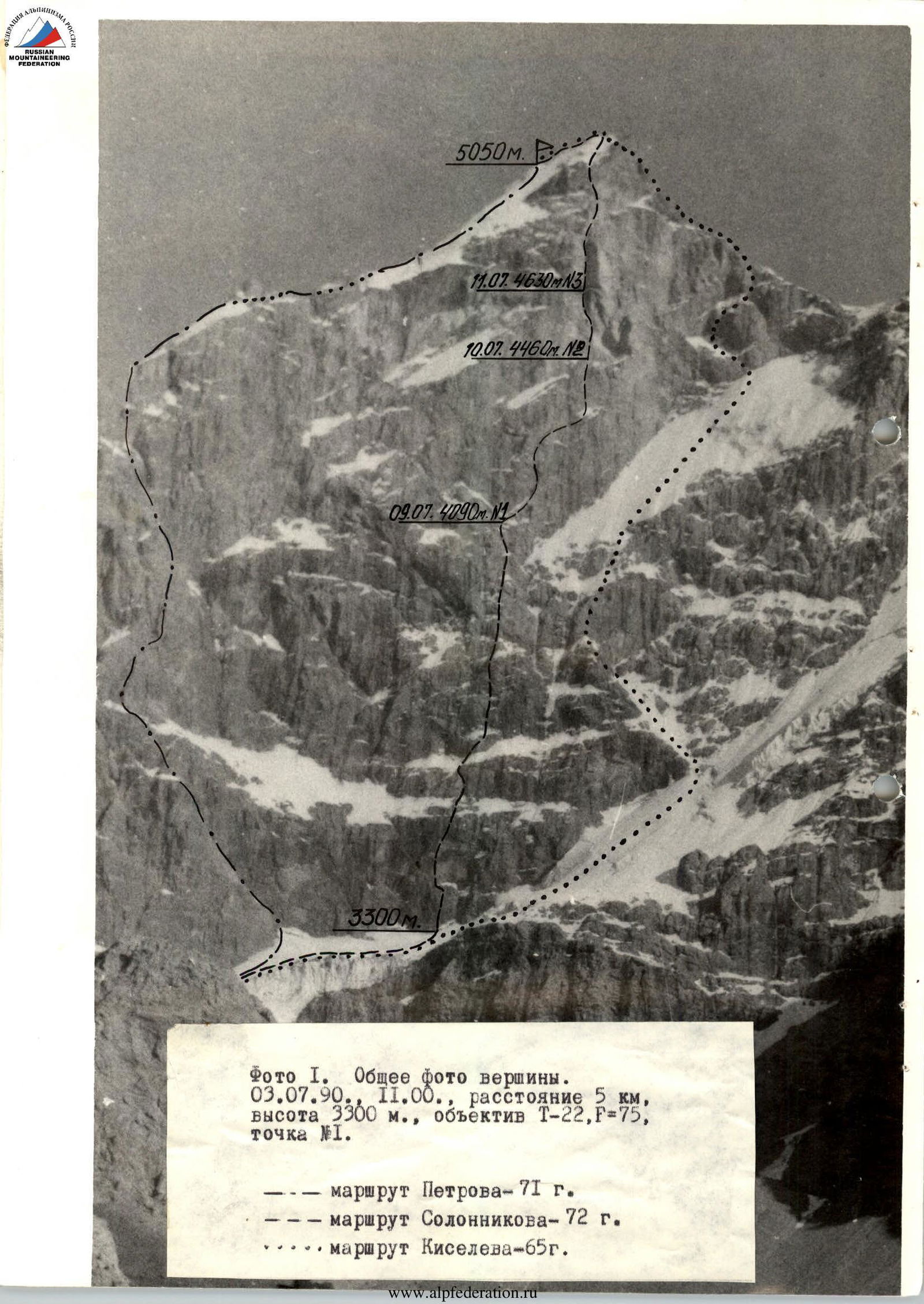
Photo 1. General photo of the summit. July 3, 1990, 11:00, distance 5 km, height 3300 m, lens T-22, F=75, point #1. — Petrov's route — 71 --- Solonnikov's route — 72 ... Kiselev's route — 65
or lower. Backpacks were attached to the belt and lifted by hand. Throughout the ascent, the first climber wore rock shoes. For safety and progression, the team used the entire arsenal of modern equipment: rock pitons, cams, various types of chocks, screw-in bolt pitons.
The ascent began between 8:00 and 9:00 am each day. The last participant arrived at the bivouac no later than 18:00 to 19:00. The first pair finished the evening route preparation between 20:00 and 21:00. Hot meals were provided in the morning and evening, and the team members received high-calorie snacks for the day.
During the second half of the ascent, the weather deteriorated sharply (temperature drop, strong wind, snow), but this did not significantly affect the team's speed due to their high physical and technical preparedness.
Throughout the ascent and descent, the team maintained constant radio contact with observers. The main rescue team was stationed at the base camp, with which the observers maintained stable radio contact.
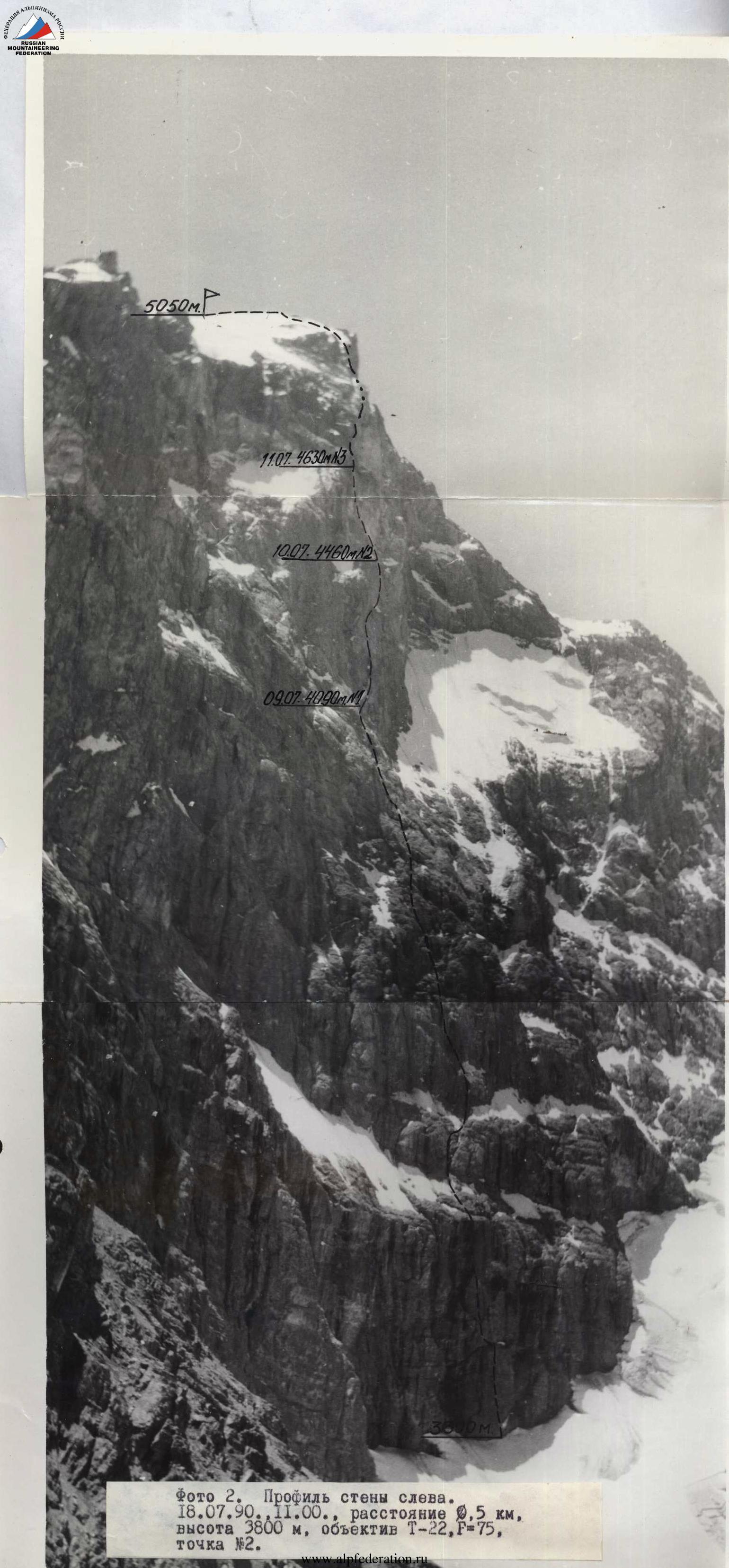
Photo 2. Profile of the wall on the left. July 18, 1990, 11:00, distance 0.5 km, height 3800 m, lens T-22, F=75, point #2.
Tactical actions of the team
When drawing up the tactical plan for the ascent, the team followed the schedule of the Samarkand team (coach Mumdji) but with a tighter time frame.
The original plan allocated two days for the main route and one reserve day for bad weather or route conditions. The alternative plan included an additional bivouac near the giant internal corner. Both plans included a day for processing the lower rock belt.
After processing the lower rock belt, the team was ready to start the route on July 8, but rain that continued throughout the night and intensified by morning prevented them from doing so. It was decided to postpone the start by a day.
On July 9, the daily plan was fully executed, but wet snow that started at night and continued throughout the next day significantly worsened the route conditions and made navigation difficult. The team had to switch to the second tactical plan and stopped for the night at 17:00 at the base of the giant internal corner.
A sharp drop in temperature the next day further complicated the passage of the internal corner (the key section of the route) — the rocks were covered in flowstone, and the shelves were snow-covered. The temperature continued to drop throughout the day.
To increase the speed, the team changed the lead climber three times during the day, and the task of passing the key section was effectively solved.
On the fourth day, at 13:45, the team reached the summit in full.
The route was completed according to the second tactical plan in 4 days, with one day spent on processing.
The team's physical and technical levels were relatively even, allowing each participant to lead on the route:
- A. Kolesov — R0–R8, R29–R31
- S. Borisov — R8–R19, R31–R33
- S. Khabibulin — R19–R28
- M. Brook — R28–R29
- A. Volegov — R40–R42
- V. Manirov — R33–R40
The first climber used a double rope, one marked UIAA and the other as a handrail. All others climbed on a fixed rope with two jumar clamps and additional top-rope protection.
Route diagram in UIAA symbols
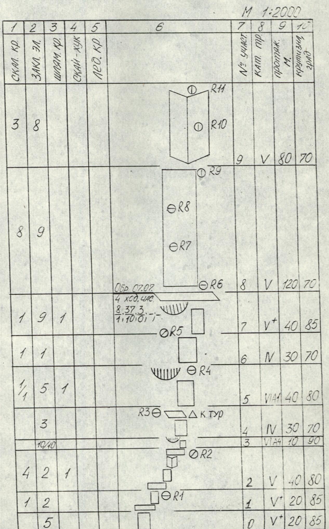
| 1 | 2 | 3 | 4 | 5 | 6 | 7 | 8 | 9 | 10 |
|---|---|---|---|---|---|---|---|---|---|
| Rock pit. | Chocks | Bolt pit. | Skyhook | Ice pit. | Comments | Diff. cat. | Climber # | Length, m | Steepness, deg. |
| R11 | |||||||||
| 3 | 8 | V | R10 | 80 | 70 | ||||
| R9 | |||||||||
| R8 | |||||||||
| 8 | 9 | V | R7 | 120 | 70 | ||||
| Work 07.07 | V+ | R6 | 40 | 85 | |||||
| 1 | 9 | 1 | 4 clim. hrs | N | R5 | 30 | 70 | ||
| 1 | 1 | 8.37.3. | VIA | R4 | 40 | 80 | |||
| 1 | 5 | 1 | 7.10.01. | N | R3 | 30 | 70 | ||
| 3 | R30, AK cairn | VIA | R2 | 10 | 90 | ||||
| 10 | 10 | V | R1 | 40 | 80 | ||||
| 4 | 2 | 1 | V+ | R0 | 20 | 85 | |||
| 5 | |||||||||
| 8 | 8 | R23 | VIA | R16 | 20 | 95 | |||
| R22 | V | R15 | 40 | 70 | |||||
| 6 | IV | R14 | 40 | 60 | |||||
| 09.07. | R21 | ||||||||
| 10 clim. hrs | |||||||||
| 3 | 25–48––2 | R20 | |||||||
| R19 | |||||||||
| 2 | 6 | IV | R13 | 120 | 60 | ||||
| R18 | |||||||||
| 6 | 10 | R17 | |||||||
| R16 | V | R12 | 120 | 70 | |||||
| R15 | |||||||||
| 3 | 6 | 2 | R14 | V | R11 | 80 | 70 | ||
| R13 | |||||||||
| 3 | 2 | R12 | IV | R10 | 80 | 65 | |||
| 2 | 2 | 19 | R37 | VIA | R32 | 20 | 90 | ||
| 1 | 1 | 3 | 4 | R36 | VIA | R31 | 15 | 80 | |
| 1 | 4 | 6 | 1* | 11.07 | VIA | R30 | 20 | 90 | |
| 8 | 3 clim. hrs | V | R29 | 40 | 90 | ||||
| 3 | 3 | 6 | 2 | 3–14–2–2 | VIA | R28 | 30 | 90 | |
| 6 | 6 | 052 10.07. | VIA | R27 | 40 | 90 | |||
| 3 | 2 | 12 | 3 clim. hrs | VIA | R26 | 40 | 90 | ||
| 2 | 3 | 6 | 5/4 24/8 | V | R25 | 40 | 65 | ||
| 1 | 5 | 10.07 #2 | V | R24 | 40 | 65 | |||
| 6 | 2 | R31 | VA | R23 | 40 | 75 | |||
| 1 | |||||||||
| 1 | 6 | 2 | 9 clim. hrs | V | R22 | 40 | 50 | ||
| 19 | 3 | 637–2 | V | R21 | 40 | 75 | |||
| 2 | 6 | VA | R20 | 40 | 65 | ||||
| 2 | 4 | 2 | 052 09.07 | VA | R19 | 40 | 65 | ||
| 6 | 6 | 4 | 10 | 3 clim. hrs | VIA | R18 | 35 | 75 | |
| 1 | 3 | 7244 | V | R17 | 20 | 80 | |||
| 10– | |||||||||
| Total: | |||||||||
| 40 clim. hrs | R41 | 150 | 20 | ||||||
| 64 216 8+7* | |||||||||
| 18 58 3 167 | |||||||||
| 12.07. | |||||||||
| 4 clim. hrs | |||||||||
| 3 | 6201 30–3 | R40 | 120 | 35 | |||||
| 1 | 1 | R44 | IV | R39 | 40 | 70 | |||
| 7 | R43 | V | R38 | 40 | 90 | ||||
| 1 | 3 | R42 | V | R37 | 40 | 80 | |||
| 2 | R41 | II | R36 | 20 | 30 | ||||
| 4 | R40 | V | R35 | 20 | 85 | ||||
| 2 | 1 | Work 11.07 | V | R34 | 40 | 80 | |||
| 4 | 1* | 4 clim. hrs | VIA | R33 | 40 | 95 | |||
| 737– |
Description of the route by sections
SECTION R0–R3. Monolithic rocks with smoothed holds.
SECTION R3–R4. A ledge with a widening crack, passed on artificial aids (AIDs). Cams, large chocks.
SECTION R4–R5. A steep slab leading to a shelf under a ledge. Cairn.
SECTION R5–R6. Steep wall with few holds. Climbing is extremely difficult.
SECTION R6–R8. Slabby rocks covered with debris, leading to the top of the lower rock belt.
SECTION R8–R9. Steep wall composed of destroyed rocks. Climbing is difficult. Protection via pitons and chocks.
SECTION R9–R10. A vaguely defined internal corner. Climbing is complicated by the strong destruction of the rocks; many loose stones.
SECTION R10–R11. Alternating walls and shelves covered with debris. Climbing is moderately difficult.
SECTION R11–R13. Steep slabby rocks. Protection via various types of chocks.
SECTION R13–R14. System of shelves, walls, and internal corners. Climbing is moderately complex. Protection via pitons and chocks.
SECTION R14–R16. Movement up and to the right along the right side of the "bird's" internal corner. Slabby rocks of increasing difficulty leading under a ledge.
SECTION R16–R17. Ledge passed on AIDs directly and then along a hanging crack.
SECTION R17–R18. Pendulum move right for 4 m into a parallel crack. Protection via small stoppers.
SECTION R18–R19. Steep rocks like "ram's foreheads." Absence of cracks. Skyhooks, protection via bolt pitons.
SECTION R19–R21. Slabby rocks. Climbing is difficult with AIDs.
SECTION R21–R23. Wall leading to slabs covered with flowstone. Protection via ice screws.
SECTION R22–R26. Steep wall cut by a crack. Protection via chocks.
SECTION R26–R29. Vertical, partly overhanging crack passed on AIDs, interrupted by a series of ledges. Located in the center of the giant internal corner. Climbing is extremely difficult. Use of chocks of all types, bolts, skyhooks.
SECTION R29–R31. Vertical corner composed of carbonaceous schist, turning into a narrow crack, with a cairn at the top on a "carrot." Climbing is very difficult.
SECTION R31–R33. Along the crack left under a ledge. The ledge is bypassed on the left via a crack interrupted by two overhangs. Climbing is extremely difficult. AIDs, use of large cams.
SECTION R33–R34. Large ledge passed on AIDs, leading to the top of the giant internal corner. Convenient shelf.
SECTION R34–R38. Strongly destroyed rocks covered with debris. Organizing protection is complicated.
SECTION R38–R39. Steep destroyed rocks. Climbing is very difficult.
SECTION R39–R40. Talus couloir leading to a snow-ice slope.
SECTION R40–R41. Ice-snow slope leading to the pre-summit ridge. Crampons, ice screws.
SECTION R41–R42. Pre-summit ridge, snow bulges.
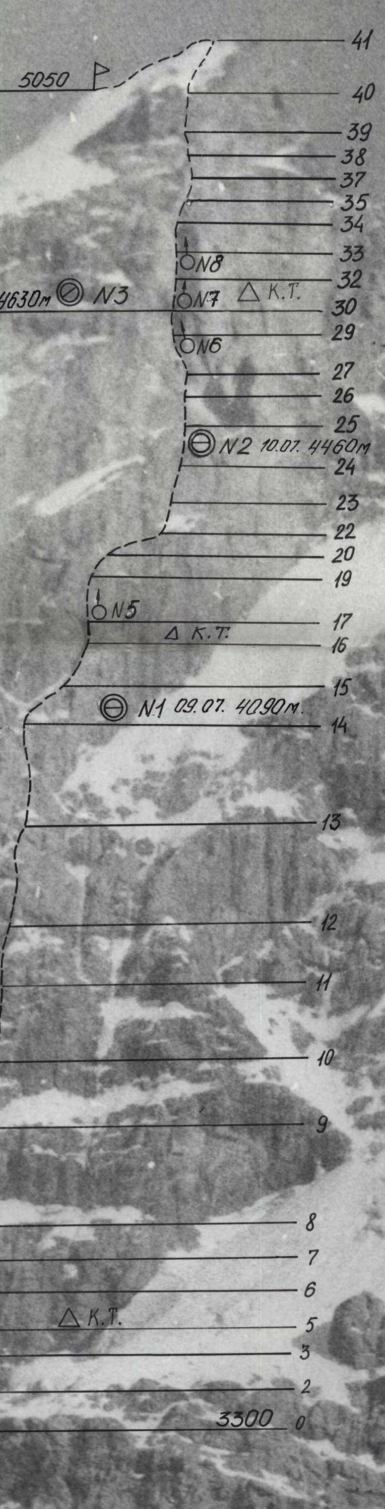
Photo 3. Technical photograph of the route. July 3, 1990, 11:00, distance 5 km, height 3300 m, lens T-22, F=75, point #3.
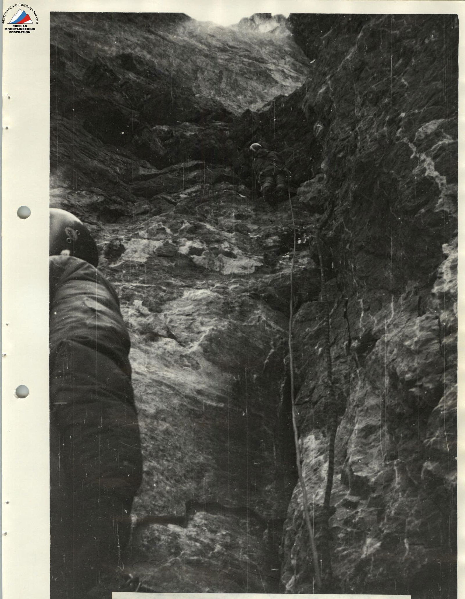
Photo 6. In the giant internal corner. Section R29. July 11, 1990, 12:00, lens T-43, F=40, point #6.
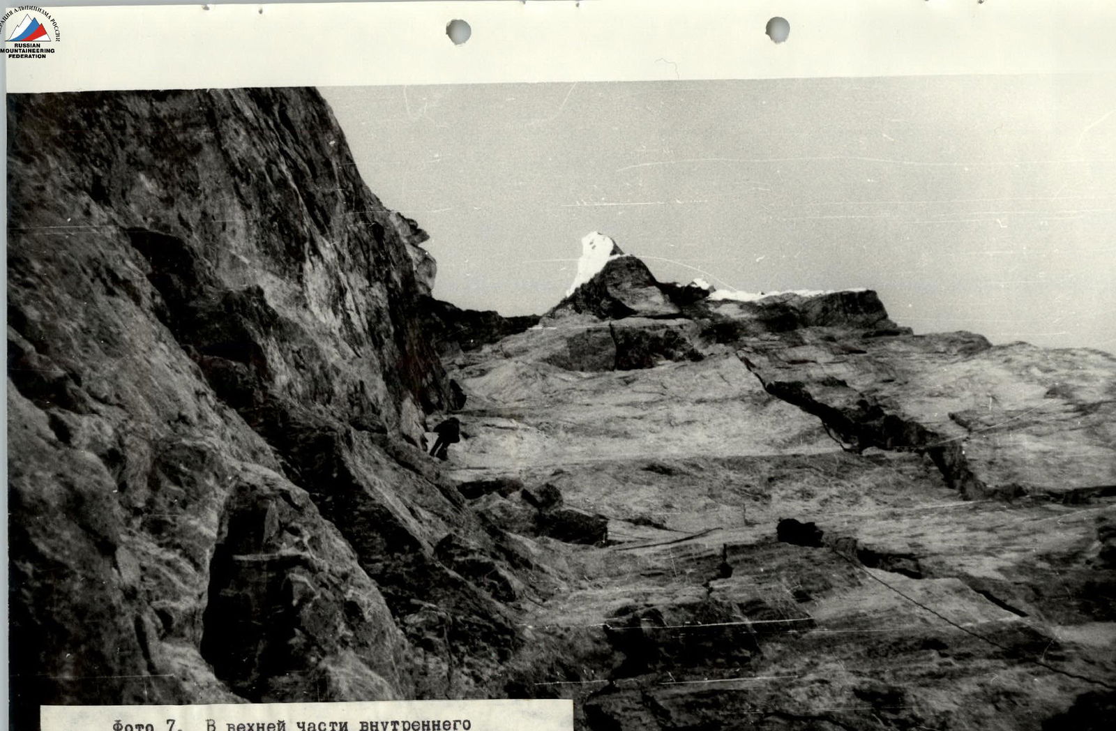
Photo 7. In the upper part of the internal corner. Section R30–R31. July 12, 1990, 10:00, lens T-43, F=40, point #7.
Judge's conclusion
on the ascent to the USSR Championship in alpinism in the category of technically complex ascents to Chapdara peak via the northwest wall
The group consisting of:
- Viktor Aleksandrovich Solonnikov — leader, coach;
- Boris Petrovich Vasiliev — participant;
- Andrey Borisovich Grachev — participant;
- Dmitry Igorevich Antonovskiy — participant;
- Vladimir Aleksandrovich Solonnikov — participant;
- Vladimir Lvovich Miasnikov — participant, from July 28 to August 11, completed the ascent according to the application. The ascent was conducted in accordance with the rules of the USSR alpinism championship, without violations, and may be presented to the judging panel of the USSR Alpinism Federation.
USSR Championship Judge Authorized representative of the USSR Sports Committee /Savvon/