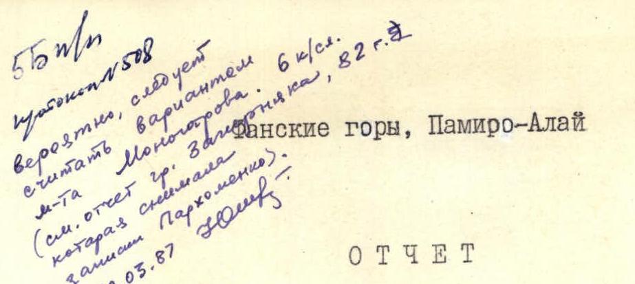
Report
on the ascent of the Artuch alpine camp instructors to Chapdara peak, 5297 m, via the NE wall (first ascent)
Group composition:
-
- Parkhomenko A.L. — Master of Sports, USSR — team leader
-
- Shchukin V.I. — Master of Sports, USSR
-
- Tomchik V.S. — Candidate for Master of Sports
-
- Osipov O.F. — Candidate for Master of Sports
-
- Vashenyuk E.V. — Candidate for Master of Sports
-
- Serebryakov Yu.A. — Candidate for Master of Sports
Alpine camp "ARTUCH", 1981
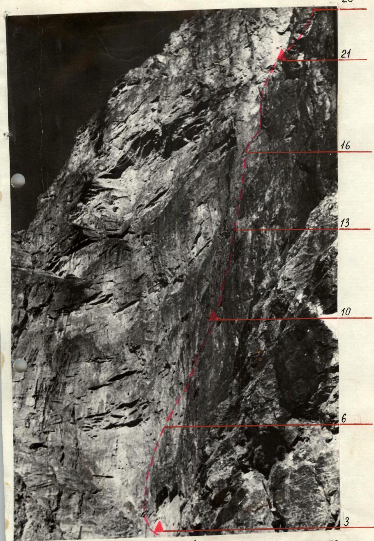
Fig. 2. Route profile photo (taken from Monogarov's route).
Description of the route passage
July 30, 1981. Early rise, breakfast, and at 5:00 the group sets out from the observers' bivouac. It's still dark, but by dawn, we approach the start of the route. It begins in the left part of the couloir coming out from under the eastern and southeastern walls of Chapdara.
We ascend through its left part (sect. R0–R1). The rocks are monolithic; piton placement is used for protection, mainly wedges and channel bars are used. Further on, the rocks become so steep that we have to move right onto the snow. The slope is quite steep, and the first person puts on crampons. Protection is provided through an ice axe anchored in the snow; where possible, pitons are driven into the rocks on the right side of the couloir (sect. R1–R2).
At 9:00, we reached the base of the wall. To the left of the stream, we climbed onto a narrow ledge protected by a cornice resembling "eyebrows." Here, we decided to set up the first night's bivouac (sect. R2–R3).
From the bivouac, at 9:30, the Shchukin–Serebryakov rope team headed out to work. On this day, we felt the wall's complexity, having worked another 115 m (sect. R3–R6). The rocks are monolithic, partly overhanging, with few cracks and holds. And this is far from the most challenging part of the route.
At 21:00, the rope team descended to the bivouac site. Here, a sitting bivouac was already set up, and water-filled flasks were prepared to be carried upwards. There will be no water further up the wall.
July 31, 1981. Cloudy, cold morning. The Vashenyuk–Parkhomenko–Shchukin trio started work at 8:00. We decided to proceed as a trio to allow for more frequent changes of the lead climber.
The direction of movement:
- from the previous work site, rightwards and upwards,
- initially along an overhanging internal corner,
- then along the wall with white patches.
Climbing is challenging; however, we manage without ladders for now. A short traverse to the right leads to a cornice, under which there's a ledge suitable for a sitting bivouac (A9–R10). Here, we also decided to set up control cairn № 1.
Suddenly, it darkened sharply. Is it bad weather again? This time, it was a solar eclipse. We were able to observe this interesting phenomenon because the sun was partially covered by clouds at that time.
While the rest of the group ascends via the suspended perilous ropes, the trio continues further. From the ledge with the control cairn, rightwards and upwards along the wall with a slight overhang (sect. R10–R11).
Soon, the monolith gives way to a section with crumbling rocks (sect. R11–R13). "Live" stones on a slope close to vertical! We have to be extremely cautious. The lead climber in the Shchukin rope team shows all his skill. Finally, the perilous ropes are secured. We push down the "live" boulders. With a terrible crash, they fall to the base of the wall, causing concern among the observers. We pass another rope length of challenging rocks. At this time, the weather deteriorates — wet snow starts falling. The trio descends. Here, on the ledge by the control cairn, a bivouac is set up. The night's rest, though sitting, is sheltered by a tent stretched along the wall. The bad weather raged throughout the night.
August 1, 1981. Cloudy morning again, though some sky is visible here and there. It's cold. All lower-lying rocks and surrounding slopes are covered in snow. However, the wall is clean; snow doesn't stick to such steep slopes.
We start moving later than usual on this day. At 8:30, we dismantle the bivouac. The Parkhomenko–Vashenyuk rope team leads.
From the end of the suspended perilous ropes (sect. R13–R14), the movement is directed towards a large red internal corner. An almost vertical internal corner with few cracks (sect. R14–R15) leads to a narrow, intermittent ledge under an overhanging wall (sect. R15–R16). There are no cracks. For protection, we use drilled pitons.
After traversing right along the ledge — an overhanging internal corner with a slit in the middle (sect. R16–R18). The rocks are wet; there are no cracks for pitons. Large-sized chocks are used in combination with ladders. Protection is on drilled pitons.
In the upper part of the internal corner — a cornice. Having overcome it, the rope team reaches a damaged slab (sect. R18–R19). The slab shows signs of rockfall, but at the top, near the base of the internal corner, a potential bivouac site is visible. However, it's already late; the rope team descends to the previous bivouac near control cairn № 1.
August 2, 1981. The weather is cold and cloudy. At 8:00, the entire group leaves the bivouac. The Tomchik–Osipov rope team leads.
We climb the perilous ropes to the prospective bivouac site at the base of the large internal corner. Here, on a narrow ledge (sect. R21–R22), a hanging bivouac is set up, and control cairn № 2 is established.
The Tomchik–Osipov rope team, in the meantime, completed a challenging traverse to the right (sect. R22–R23) and reached the right edge of the large internal corner. Upwards, a significant overhanging section of the wall is visible. It appears we've reached the most challenging part of the route. For tomorrow, we prepare particularly carefully. As a "tea treat," we receive an additional water ration.
August 3, 1981. Extremely cold in the morning, despite clear weather. A strong wind is blowing. Working on the wall is challenging. We left the bivouac at 9:00. The Shchukin–Parkhomenko–Vashenyuk trio leads.
Characteristics of the section:
- vertical, smoothed slabs,
- rock type — soft limestone,
- due to weathering, the surface is so smooth that even climbing boots slip on it,
- few places for piton placement (sect. R23–R24).
The wall's inclination changes from vertical to negative, and the wall becomes a vaguely defined internal corner (sect. R26–R28). Now, almost every meter requires ladders. "Sky-hooks" come into play. Shchukin uses them. For protection, drilled pitons are still used. Safety first.
Progress is slow. The challenges of the wall are compounded by the intense cold. By 18:00, the trio descends to the bivouac site. Only 60 m were covered today, and it seems tomorrow won't be any easier.
August 4, 1981. Very early rise. The weather is good and seems warmer than yesterday. The Shchukin–Parkhomenko–Vashenyuk trio leads again.
Continuing the passage of the overhanging internal corner (sect. R26–R27):
- the same slippery rocks,
- ladders are still in use,
- now "sky-hooks" are used — Shchukin operates them,
- protection is on drilled pitons.
Progress is slow; every meter is a struggle. At the top of the overhanging internal corner — a cornice.
By the end of the day, the entire group ascends and sets up a hanging bivouac. Above the cornice, control cairn № 3 is suspended from a water flask.
At this time, the lead trio, using "sky-hooks," passes a monolithic section of the wall (sect. R27–R28) and descends to the bivouac site where the whole group is now "hanging."
The bivouac is indeed the most uncomfortable of all previous ones. However, everyone's mood is elevated — we're confident that the most challenging section of the wall is behind us.
August 5, 1981. Early start. The Serebryakov–Osipov–Tomchik trio leads.
From the end of the secured perilous ropes — a short traverse to the right towards a vaguely defined rock pillar (sect. R28–R29). Along the right side of the rock pillar:
- in the lower part, it's monolithic and fractured (climbing is challenging),
- in the second half of the day, the trio reaches the top of the pillar to a small ledge (sect. R32).
While the group catches up and sets up a hanging bivouac at different levels, the trio manages to work another 15 m on the wall (sect. R32–R33).
August 6, 1981. Clear morning, good weather. At 7:00, the Osipov–Tomchik–Shchukin trio heads up.
Characteristics of the section:
- smoothed but relatively gentle (60°) slabs,
- lead to the wall of the upper bastion,
- another 70 m of rocks covered in rime ice.
After a vertical 40 m section, an overhang begins (sect. R34–R36). The path then follows a narrow, ice-filled crevice cutting through the overhanging section. For progress, ice diffis are used.
Just a few meters remain to the snowy ridge. We step onto a small rock ledge covered in ice. Further movement continues along the snowy ridge. The snow is compact, dense, already transitioning to firn at a shallow depth. The lead climbers put on crampons. Alternate protection is provided through an ice axe hammered into the snow (sect. R37–R38).
By 12:30, we approached a gendarme on the pre-summit slope. The gendarme is overcome head-on (sect. R38–R39). Shchukin leads first. Soon, perilous ropes are hung, and the entire group reaches the destroyed rock ridge leading to the pre-summit snowy-icy ascent (sect. R40–R41).
Characteristics of the ascent:
- the slope is quite steep (over 40°),
- the snow is hard,
- everyone puts on crampons,
- alternate protection through an ice axe hammered into the snow.
In the upper part of the ascent, a surprise awaits: the slope's steepness increases sharply, and almost to the ridge, ice glistens (sect. R41–R42). Ice screws come into play. But this is the final effort.
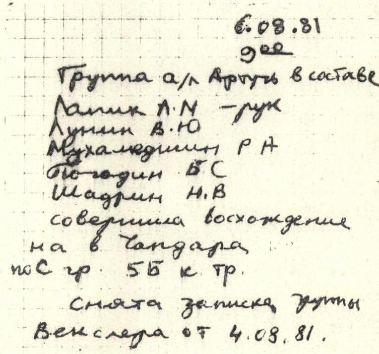
At 16:30, the entire group is on the pre-summit ridge, and at 17:00, we're on the summit. A note is written, we take a group photo against the backdrop of surrounding mountains, and then head down. We need to descend before dark.
At 20:00, we reached the moraine of the Bodkhona glacier, and at 22:00, we set up a bivouac near the Alauddin lakes.
August 7, 1981. At 14:00, the entire group, via the Alauddin pass, proceeded to the base camp of the Artuch alpine camp on the Kulikalon lakes.
Note from the summit
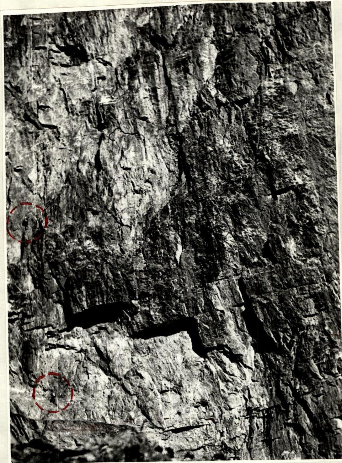
Fig. P.2. Section R3–R4. Cornice "brov'".
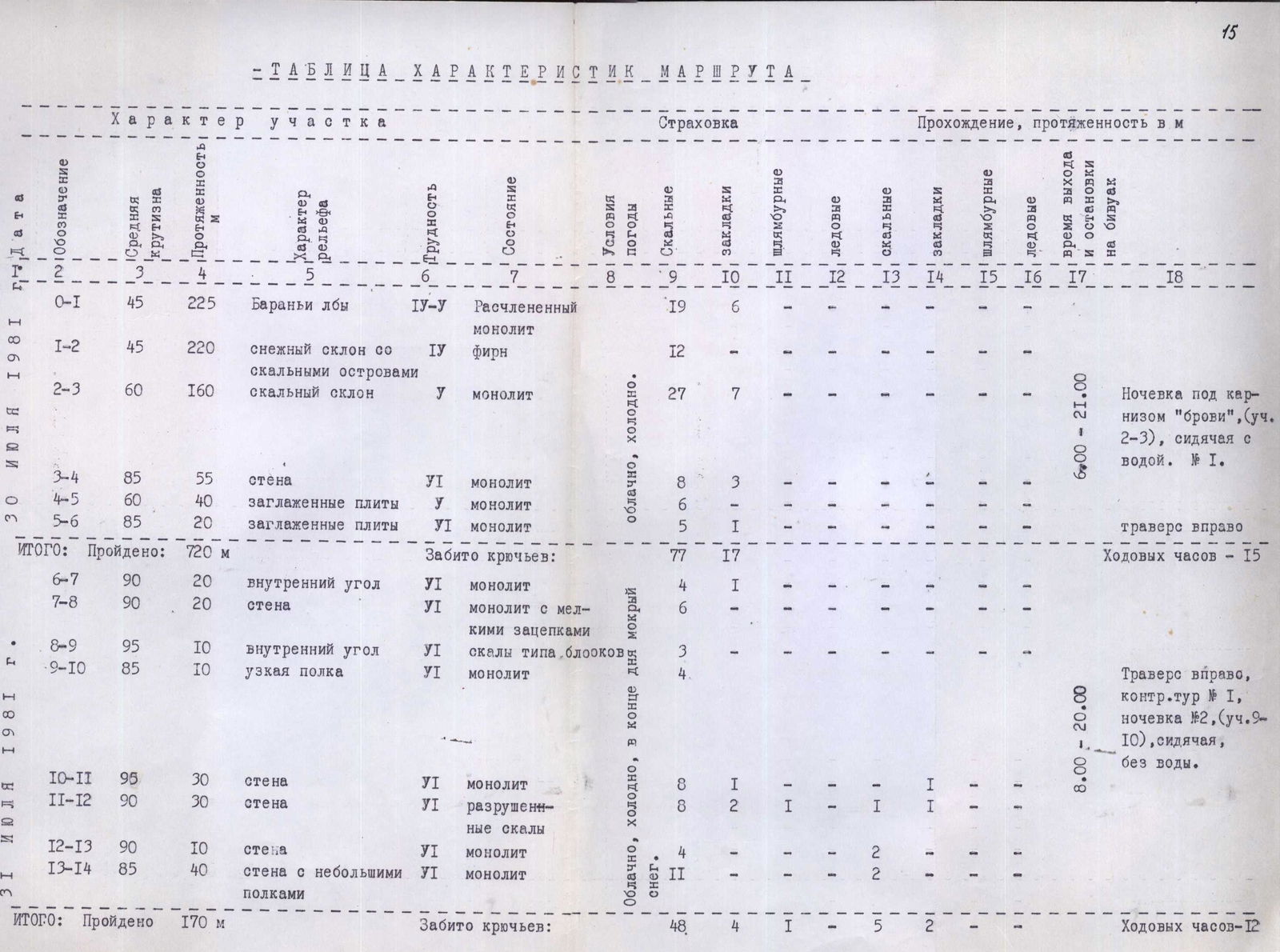
Route characteristics table
| Date | Section | Steepness (°) | Length (m) | Terrain characteristics | Rock type | Difficulty | Weather | Protection: Rock | Protection: Chocks | Protection: Drilled | Climbing: Rock | Climbing: Chocks | Climbing: Drilled | Climbing: Ice | Time (hh:mm–hh:mm) | Note |
|---|---|---|---|---|---|---|---|---|---|---|---|---|---|---|---|---|
| July 30, 1981 | R0–R1 | 45 | 225 | Ram's foreheads | Fractured monolith | 4 | 19 | 6 | ||||||||
| R1–R2 | 45 | 220 | Snow slope with rock outcrops | Firn | 4 | 12 | 1 | |||||||||
| R2–R3 | 60 | 160 | Rocky slope | Monolith | 5 | Cloudy, cold | 27 | 7 | 6:00–21:00 | Bivouac under the "brov'" cornice (sect. R2–R3), sitting with water. № 1. | ||||||
| TOTAL: | 720 | Pitons driven: 77 | 17 | Operating hours — 15 | ||||||||||||
| July 31, 1981 | R3–R4 | 85 | 55 | Wall | Monolith | 6 | 8 | 3 | ||||||||
| R4–R5 | 60 | 40 | Smoothed slabs | Monolith | 5 | 6 | ||||||||||
| R5–R6 | 85 | 20 | Smoothed slabs | Monolith | 6 | 5 | 1 | |||||||||
| R6–R7 | 90 | 20 | Internal corner | Monolith | 6 | 4 | 1 | Traverse to the right | ||||||||
| R7–R8 | 90 | 20 | Wall | Monolith with small holds | 6 | 4 | ||||||||||
| R8–R9 | 95 | 10 | Internal corner | Rocks like blocks | 6 | 3 | ||||||||||
| R9–R10 | 85 | 10 | Narrow ledge | Monolith | 6 | 4 | 8:00–20:00 | Traverse to the right, control cairn № 1, bivouac № 2 (sect. R9–R10), sitting, without water. | ||||||||
| R10–R11 | 95 | 30 | Wall | Monolith | 6 | Cloudy, cold, wet snow in the evening | 8 | 1 | 1 | 1 | ||||||
| R11–R12 | 90 | 30 | Wall | Crumbling rocks | 6 | 8 | 2 | 1 | 1 | 1 | ||||||
| R12–R13 | 90 | 10 | Wall | Monolith | 6 | 4 | 2 | 2 | ||||||||
| R13–R14 | 85 | 40 | Wall with small ledges | Monolith | 6 | 4 | 2 | |||||||||
| TOTAL: | 170 | Pitons driven: 48 | 4 | 1 | 5 | 2 | Operating hours — 12 | |||||||||
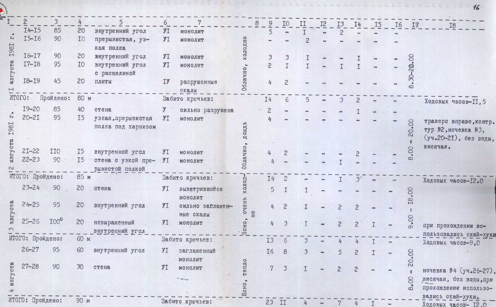
| August 1, 1981 | R14–R15 | 85 | 20 | Internal corner | Monolith | 6 | Cloudy, cold | 5 | 1 | |||||||
| R15–R16 | 90 | 10 | Intermittent, narrow ledge | Monolith | 6 | 2 | 2 | 1 | ||||||||
| R16–R17 | 90 | 20 | Internal corner | Monolith | 6 | 4 | 2 | |||||||||
| R17–R18 | 95 | 10 | Internal corner with a slit | Monolith | 6 | 14 | 6 | 5 | 2 | |||||||
| R18–R19 | 45 | 20 | Slabs | Crumbling rocks | 4 | 4 | ||||||||||
| TOTAL: | 80 | Pitons driven: 32 | 18 | 1 | 3 | Operating hours — 11.5 | ||||||||||
| August 2, 1981 | R19–R20 | 85 | 40 | Wall | Heavily damaged | 5 | Cloudy, rain | 4 | 8:30–20:00 | Traverse to the right, control cairn № 2, bivouac № 3 (sect. R20–R21), without water, hanging. | ||||||
| R20–R21 | 95 | 15 | Narrow, intermittent ledge under a cornice | Monolith | 6 | 11 | 2 | |||||||||
| R21–R22 | 110 | 15 | Internal corner | Monolith | 6 | 4 | 4 | 2 | ||||||||
| R22–R23 | 90 | 15 | Wall with a narrow, intermittent ledge | Monolith | 6 | 4 | 2 | 1 | ||||||||
| TOTAL: | 85 | Pitons driven: 14 | 2 | 1 | 3 | Operating hours — 12.0 | ||||||||||
| August 3, 1981 | R23–R24 | 90 | 20 | Wall | Weathered monolith | 6 | Clear, very cold | 5 | 1 | 1 | 9:00–18:00 | |||||
| R24–R25 | 95 | 20 | Internal corner | Highly smoothed rocks | 6 | 4 | 2 | 1 | 2 | 2 | ||||||
| R25–R26 | 100 | 20 | Unclear internal corner | Monolith | 6 | 4 | 3 | 1 | 2 | 2 | ||||||
| TOTAL: | 60 | Pitons driven: 13 | 6 | 3 | 4 | 4 | 1 | Operating hours — 9.0 | ||||||||
| August 4, 1981 | R26–R27 | 95 | 60 | Internal corner | Smoothed monolith | 6 | Clear, warm | 16 | 8 | 3 | 5 | 2 | 1 | 8:00–20:00 | Bivouac № 4 (sect. R26–R27), hanging, without water; "sky-hooks" were used during the passage. | |
| R27–R28 | 90 | 30 | Wall | Monolith | 6 | 7 | 3 | 1 | 2 | 2 | ||||||
| TOTAL: | 90 | Pitons driven: 23 | 11 | 4 | 7 | 4 | 1 | Operating hours — 12.0 | ||||||||
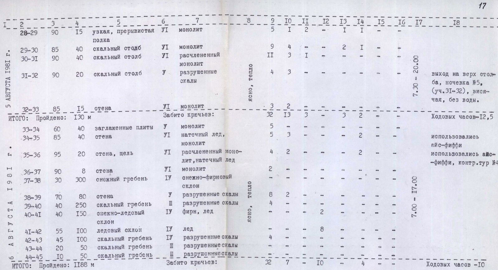
| August 5, 1981 | R28–R29 | 90 | 15 | Narrow, intermittent ledge | Monolith | 6 | Clear, warm | 9 | 5 | 1 | 2 | 1 | Reached the top of the pillar, bivouac № 5 (sect. R31–R32), hanging, without water. | |||
| R29–R30 | 85 | 40 | Rock pillar | Monolith | 6 | 9 | 4 | 2 | 1 | |||||||
| R30–R31 | 90 | 40 | Rock pillar | Fractured monolith | 6 | 11 | 3 | 1 | ||||||||
| R31–R32 | 90 | 20 | Rock pillar | Crumbling rocks | 5 | 4 | 3 | |||||||||
| R32–R33 | 85 | 15 | Wall | Monolith | 6 | 3 | 2 | 7:30–20:00 | ||||||||
| TOTAL: | 130 | Pitons driven: 32 | 13 | 3 | 3 | Operating hours — 12.5 | ||||||||||
| August 6, 1981 | R33–R34 | 60 | 40 | Smoothed slabs | Monolith | 5 | Clear, warm | 5 | 2 | Ice diffis were used | ||||||
| R34–R35 | 85 | 40 | Wall | Rime ice, monolith | 6 | 5 | 3 | 1 | 2 | Ice diffis were used, control cairn № 4 | ||||||
| R35–R36 | 95 | 20 | Wall, crevice | Fractured monolith, rime ice | 6 | 4 | 2 | 2 | ||||||||
| R36–R37 | 90 | 8 | Wall | Monolith | 6 | 2 | ||||||||||
| R37–R38 | 30 | 300 | Snowy ridge | Snow-firn slope | 4 | 1 | ||||||||||
| R38–R39 | 70 | 80 | Wall | Crumbling rocks | 5 | 8 | 2 | |||||||||
| R39–R40 | 40 | 250 | Rocky ridge | Crumbling rocks | 3 | 4 | 2 | |||||||||
| R40–R41 | 40 | 150 | Snow-ice slope | Firn, ice | 4 | 4 | 7:00–17:00 | |||||||||
| R41–R42 | 55 | 100 | Ice slope | Ice | 4 | 11 | 8 | |||||||||
| R42–R43 | 45 | 100 | Rocky ridge | Crumbling rocks | 4 | 4 | 1 | |||||||||
| R43–R44 | 20 | 50 | Rocky ridge | Crumbling rocks | 3 | 9 | ||||||||||
| R44–R45 | 10 | 50 | Rocky ridge | Crumbling rocks | 3 | |||||||||||
| TOTAL: | 1188 | Pitons driven: 32 | 7 | 10 | 4 | Operating hours — 10 |
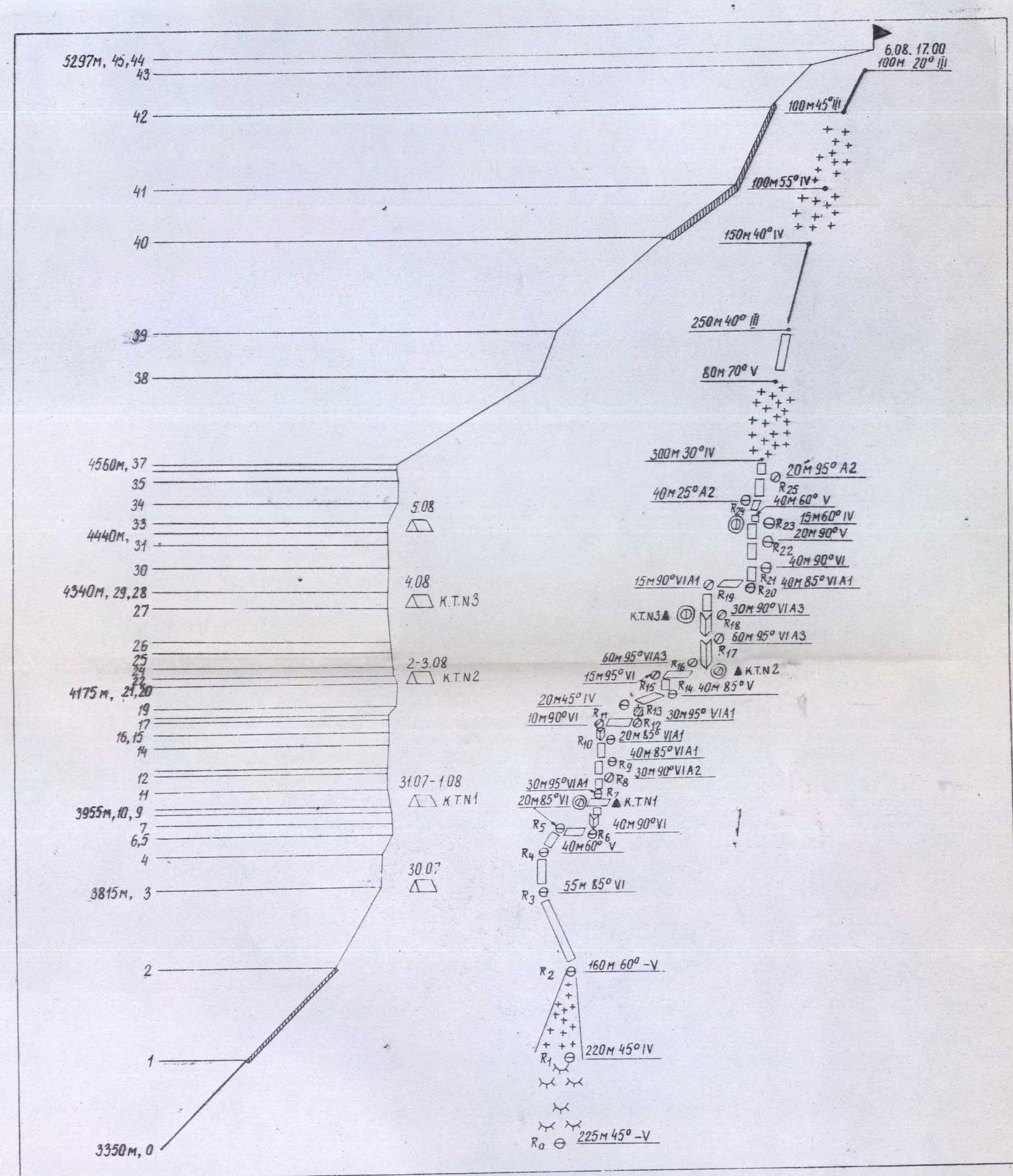
Fig. 4. Profile drawing of the route and diagram of its passage in UIAA symbols.