Ascent Passport
I. Ascent Class: Technical 2. Ascent Area: Pamir-Alay, Zeravshan Range (Fann Mountains). 3. Chapdara Peak, 5049 m, via the right part of the NE wall. 4. Proposed Difficulty Category — 5B (first ascent). 5. Route Characteristics: - Height difference — 1300 m. - Length of sections with 5–6 difficulty category — 860 m. - Average steepness — 65° - Average steepness of the wall section — 80° 6. Pitons driven (for belaying): - Rock pitons — 110 - Chocks and other protection — 128 7. Climbing time — 26.5 hours 8. Number of bivouacs: two bivouacs, comfortable, lying down. 9. Ascent Participants: - Vekhter Vladimir Viktorovich, CMS — leader - Morev Nikolay Borisovich, CMS - Povetin Anatoly Alekseevich, CMS - Ryabov Stanislav Gennadievich, CMS 10. Team Coach: Timofeev A.V. II. Date of departure and return: July 1 – July 3, 1984
- — data from the KSP in Fann Mountains 1984
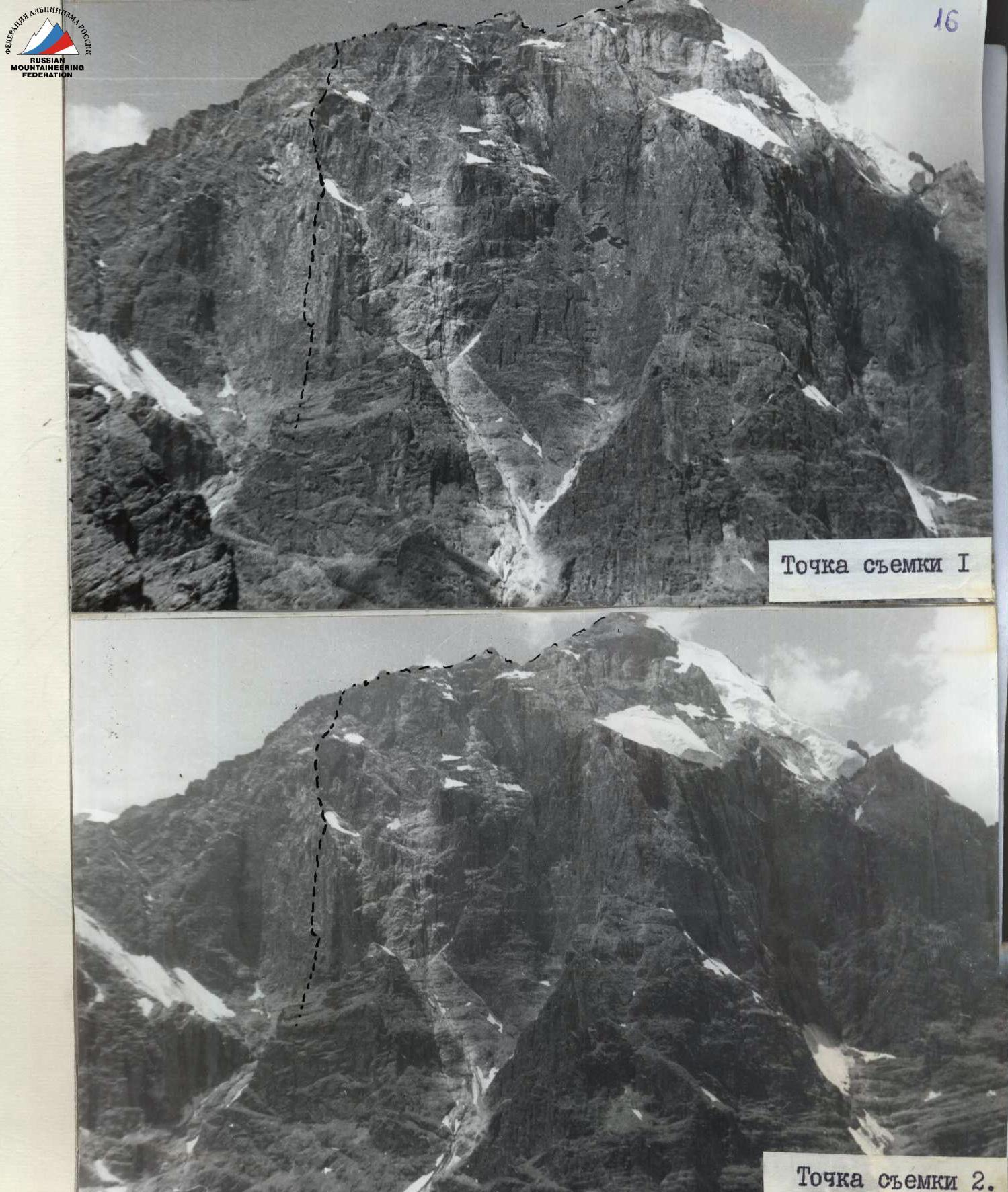
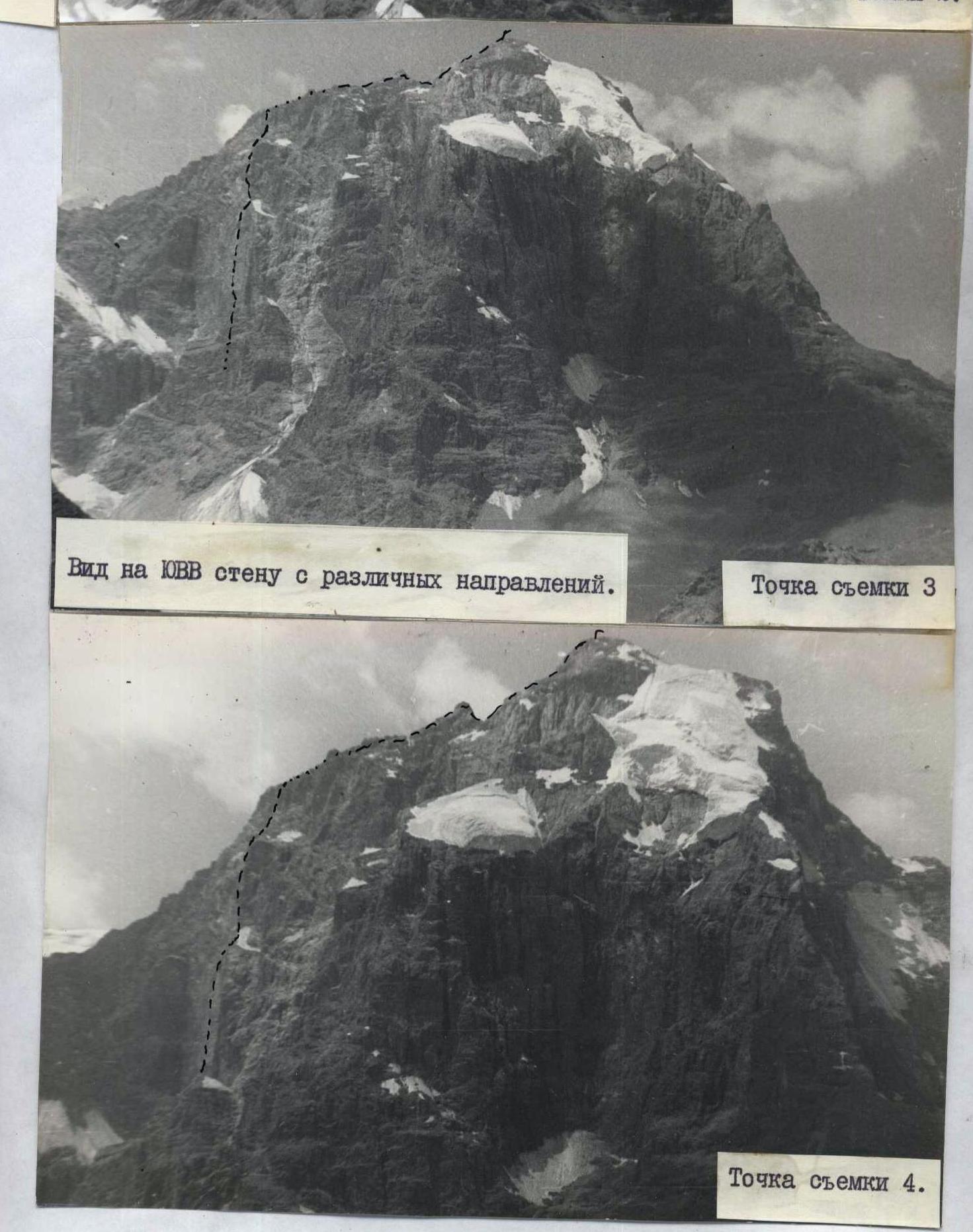
Shooting point 2.
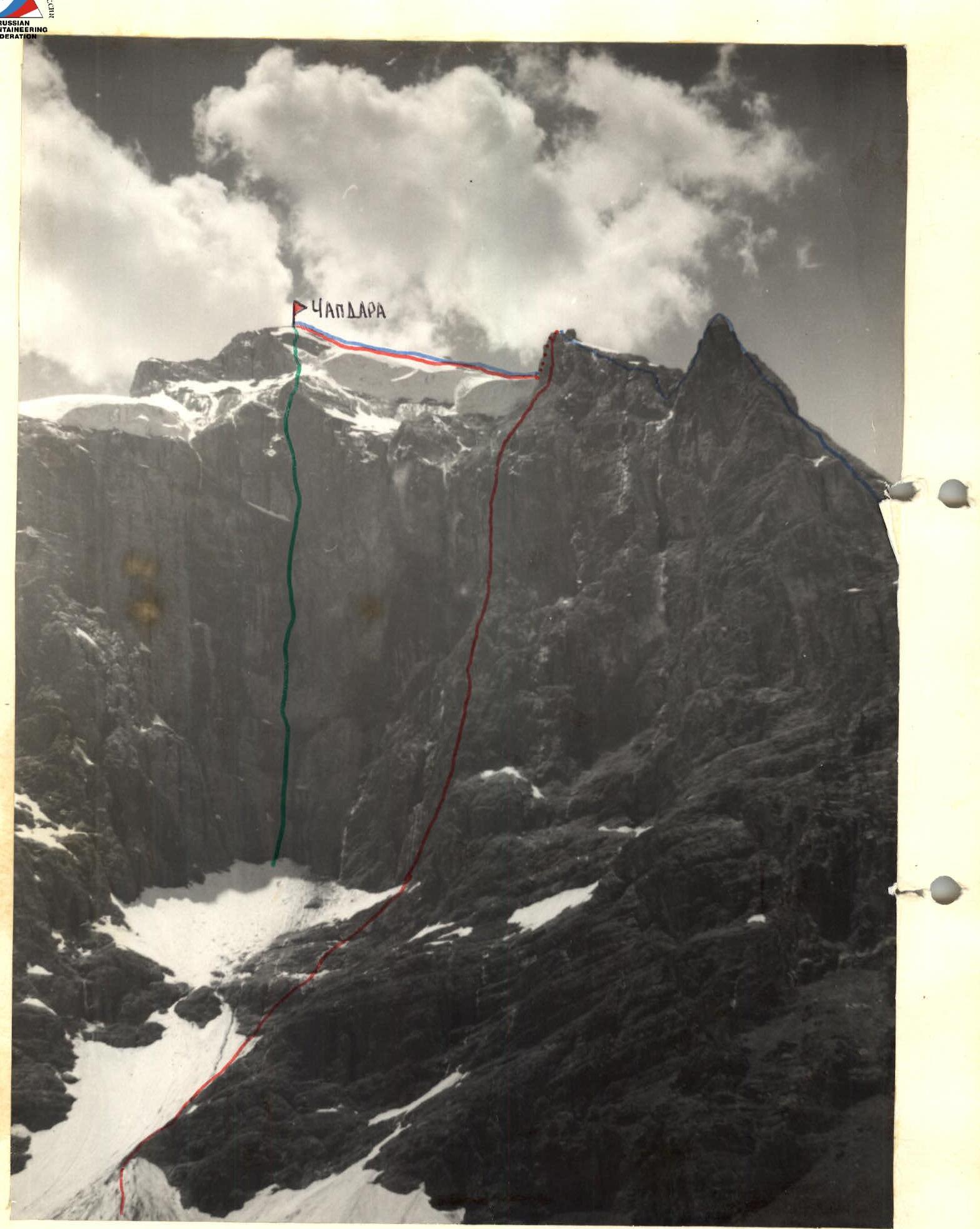
Group's Route:
via N ridge, 5A (U. Usenov)
via the center of the NE wall, 6 (A. Vinokurov)
General photo of the route
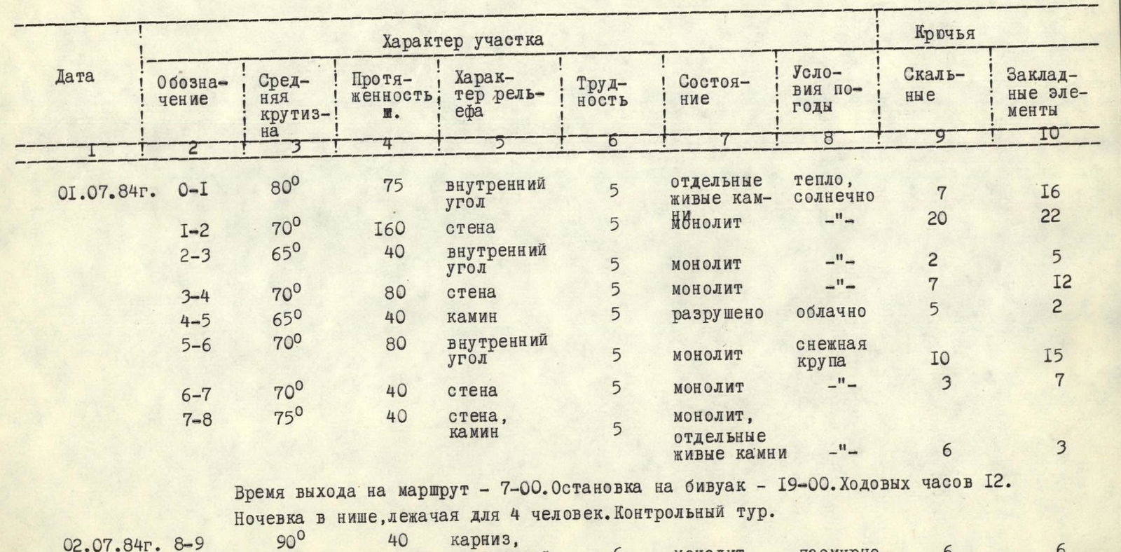
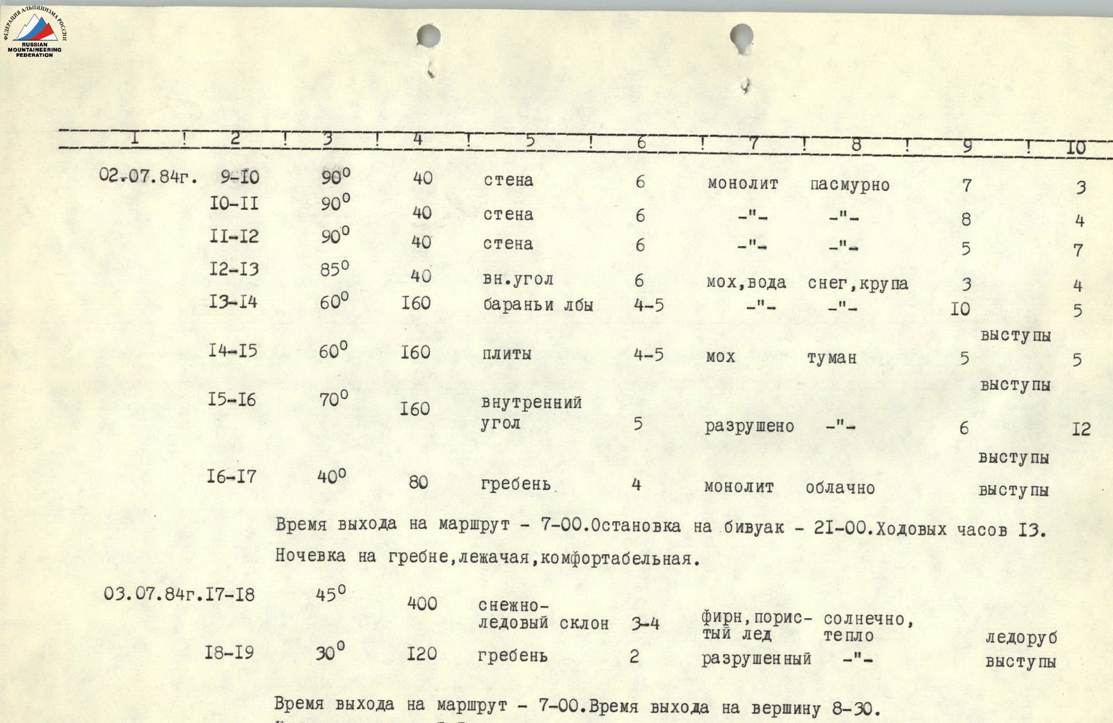
Table of Main Characteristics of the Ascent Route
| Date | Designation | Average Steepness | Length, m | Terrain Character | Difficulty | Condition | Weather Conditions | Rock Pitons | Chocks and other protection |
|---|---|---|---|---|---|---|---|---|---|
| 01.07.1984 | R0–R1 | 80° | 75 | internal corner | 5 | individual loose rocks | warm, sunny | 7 | 16 |
| R1–R2 | 70° | 160 | wall | 5 | monolith | «—» | 20 | 22 | |
| R2–R3 | 65° | 40 | internal corner | 5 | monolith | «—» | 2 | 5 | |
| R3–R4 | 70° | 80 | wall | 5 | monolith | «—» | 7 | 12 | |
| R4–R5 | 65° | 40 | chimney | 5 | destroyed | cloudy | 5 | 2 | |
| R5–R6 | 70° | 80 | internal corner | 5 | monolith | snow grains | 10 | 15 | |
| R6–R7 | 70° | 40 | wall | 5 | monolith | «—» | 3 | 7 | |
| R7–R8 | 75° | 40 | wall, chimney | 5 | monolith, individual loose rocks | «—» | 6 | 3 | |
| 02.07.1984 | R8–R9 | 90° | 40 | cornice, internal corner | 6 | monolith | overcast | 6 | 6 |
| R9–R10 | 90° | 40 | wall | 6 | monolith | overcast | 7 | 3 | |
| R10–R11 | 90° | 40 | wall | 6 | «—» | «—» | 8 | 4 | |
| R11–R12 | 90° | 40 | wall | 6 | «—» | «—» | 5 | 7 | |
| R12–R13 | 85° | 40 | internal corner | 6 | moss, water | snow, grains | 3 | 4 | |
| R13–R14 | 60° | 160 | "ram's foreheads" | 4–5 | «—» | 10 | 5 | ||
| R14–R15 | 60° | 160 | slabs | 4–5 | moss | fog | 5 | ledges | |
| R15–R16 | 70° | 160 | internal corner | 5 | destroyed | «—» | 6 | 12 | |
| R16–R17 | 40° | 80 | ridge | 4 | monolith | cloudy | ledges | ||
| 03.07.1984 | R17–R18 | 45° | 400 | snow-ice slope | 3–4 | firn, porous ice | sunny, warm | ice axe | |
| R18–R19 | 30° | 120 | ridge | 2 | destroyed | «—» | ledges |
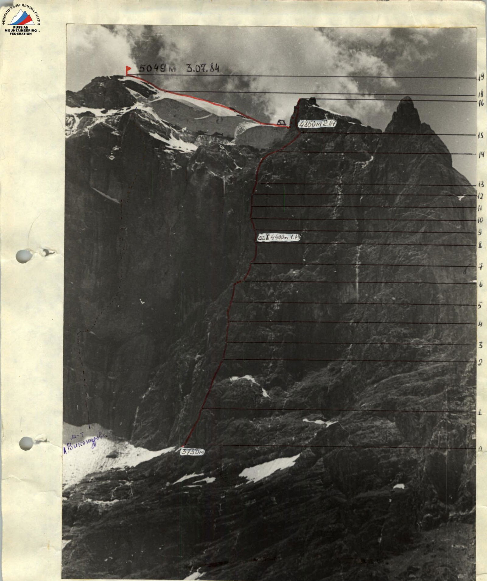
Departure time — 7:00. Stop for bivouac — 19:00. Climbing time 12 hours. Bivouac in a niche, lying down for 4 people. Control tour.
Departure time — 7:00. Stop for bivouac — 21:00. Climbing time 13 hours. Bivouac on the ridge, lying down, comfortable.
Departure time — 7:00. Summit time — 8:30. Climbing time — 1.5 hours.

Route profile on the right
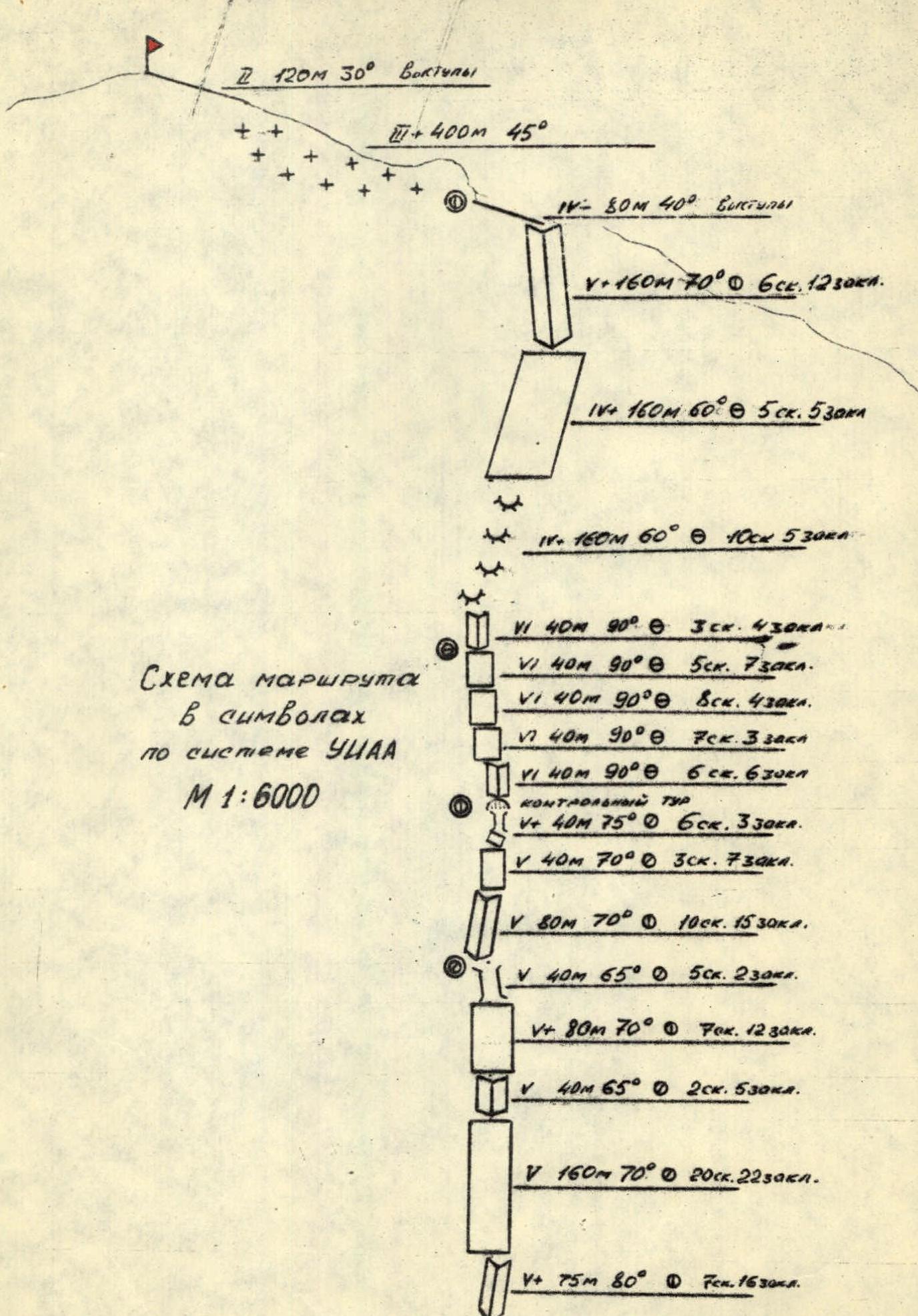
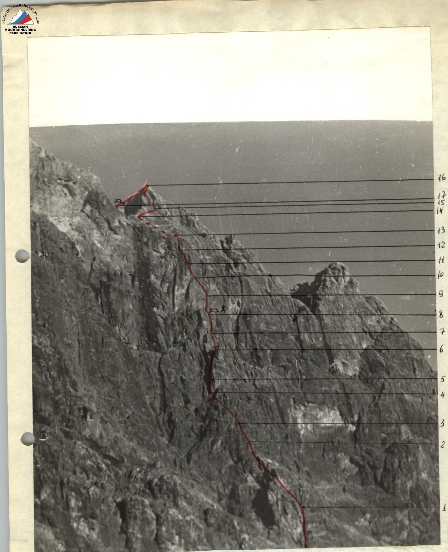
Route profile on the left
Brief Explanation of the Table of Main Characteristics of the Ascent Route
Section R0–R1. 20 meters to the left of the right edge of the ledge, which runs under the NE wall, is the start of a characteristic internal corner with a gap. The internal corner leads to the ridge of the wall counterfort, along which the first part of the route goes. The first 5 m are overhanging. There are loose rocks. Uncomfortable belay spot after the first rope (40 m). The exit to the counterfort is a convenient ledge.
Section R1–R2. Direction of movement — straight up. Four ropes of difficult climbing. Each rope has an overhanging section. Convenient spots for chocks. As if on order, after 40 m — a small ledge for 2–3 people.
Section R2–R3. Characteristic internal corner. The direction of movement is unambiguous.
Section R3–R4. Wall with few holds. Convenient belay spots.
Section R4–R5. Direction of movement towards a characteristic "tooth" (flake) on the counterfort. Chimney — many loose rocks.
Section R5–R6. Along a small ledge to the left 5 meters — entrance to an internal corner leading to the top of the "tooth". Wet rocks! To the left — a waterfall. Between the "tooth" and the wall — a small bridge.
Section R6–R7. Up and to the right along the wall — 40 meters of difficult climbing. At the top — a convenient belay spot, the group can gather. The path to the left along an inclined ledge to the waterfall is visible — do not go that way!
Section R7–R8. Up and to the right along the wall — exit to a characteristic chimney with steep walls. Climbing is done using bridging. Exit from the chimney — loose rocks. Exit directly into a grotto where a tent can be pitched. The ground is red clay. To the left along a ledge, 10 m away — water trickling down the wall. The grotto is 40 meters to the right of the waterfall. In the grotto — a control tour: a can on a piton.
Section R8–R9. Start from a ledge to the left of the grotto. Along the wall to the right — exit above the grotto, into an internal corner. Movement via rappel can start from the bivouac. The corner is absolutely vertical — exit from it is overhanging. Then slightly to the left along the wall — onto a small inclined ledge. Very difficult section!
Section R9–R10. Along the wall to the left and up — towards a small flake on which one person can stand uncomfortably.
Section R10–R11. Straight up the wall — the first 10 m are overhanging. Uncomfortable spots for driving pitons. Approach under an overhanging cornice. Belay — sitting in a harness. Very difficult!
Section R11–R12. Under the cornice to the right — 10 m, and then up and to the left along the wall without gaps towards the waterfall. Exit onto a horizontal ledge 5 meters to the right of the waterfall. Above the ledge, the wall is overhanging. Moss, water flowing. On the ledge, two people can sit. Extremely difficult section!
Section R12–R13. Through the cornice — exit into an internal corner leading to the top of the wall. Very wet, moss. Exit onto the cornice — with a boost. At the top — a convenient belay spot. To the left — a stream.
Section R13–R14. To the right of the stream — along "ram's foreheads" movement towards a hanging serac. Wet, moss.
Section R14–R15. To the right — a characteristic counterfort leading to the ridge. Movement along slabs traverses from left to right towards the start of a pronounced internal corner.
Section R15–R16. Movement from right to left along the internal corner. The last 40 meters — vertically up. There are overhanging sections. Convenient spots for driving pitons. Exit onto a known route along the N ridge.
Section R16–R17. Along the ridge to the left — exit onto a platform under the "frog".
Section R17–R18. 40 meters along the snow — exit into a snow corrie above the "frog". Then — through a bergschrund onto a large snow field. Crampons are a must! Along the snow to the left and then to the right — exit onto the ridge to the right of the summit.
Section R18–R19. Along a simple ridge — exit onto the summit.