Ascent Passport
- Ascent class — high-altitude technical.
- Northern spur of the Eastern Fan Ridge.
- Peak — Chapdara, height 5297 m, via the central part of the Northern wall “KOLODETS”.
- Estimated difficulty category — 6B cat. diff.
- Route characteristics: height difference — 2200 m, length of sections with V cat. diff. — 320 m, length of sections with VI cat. diff. — 530 m, average steepness — 85°.
- Pitons hammered for belaying: rock and wired — 185 pcs., bolted — 6 pcs., ice — 9 pcs. For creating artificial points of support: rock and wired — 68 pcs., bolted — 11 pcs.
- Number of climbing hours — 101 h.
- Number of overnight stays — eight, sitting and semi-reclining.
- Participants: Vinokurov Anatoly Filippovich — MS, captain Zhurzdin Vladimir Iosifovich — MS, Merlis Viktor Petrovich — MS, Dzhaparidze Yuri Atarovich — CMS, Vorobyov Lev Fedorovich — CMS, Monaenkov Evgeny Ivanovich — CMS.
- Team coach: Dauter Boris Vladimirovich — Master of Sports.
- Date of departure on the route — July 8, 1979. Date of return — July 16, 1979.
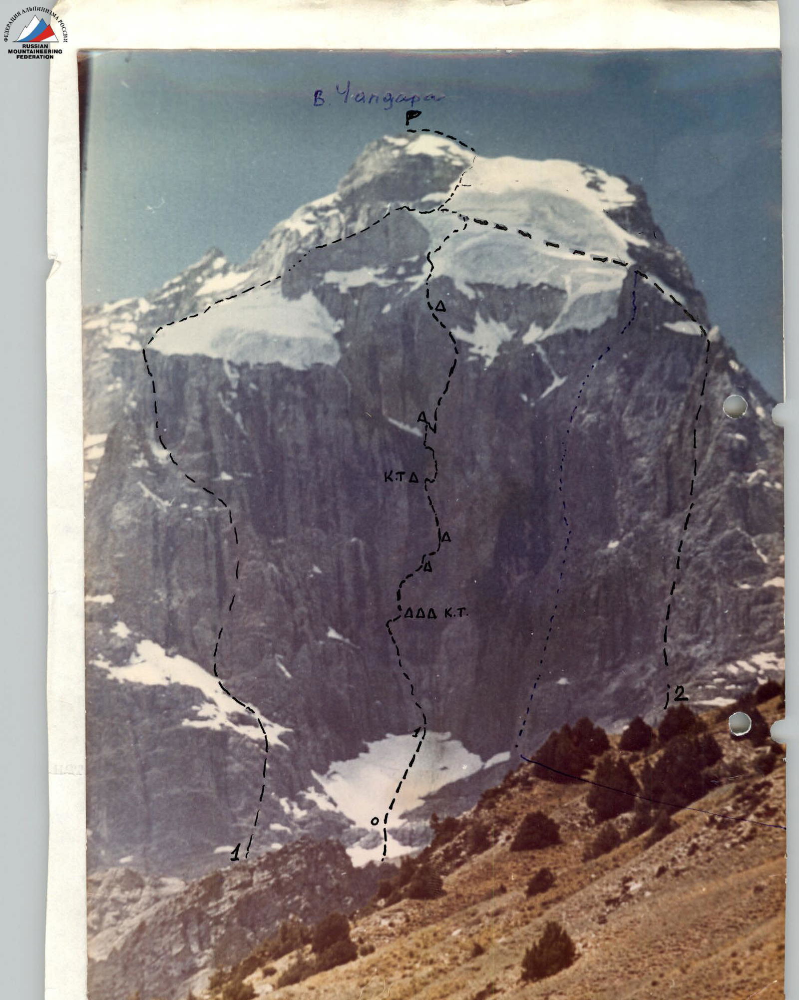
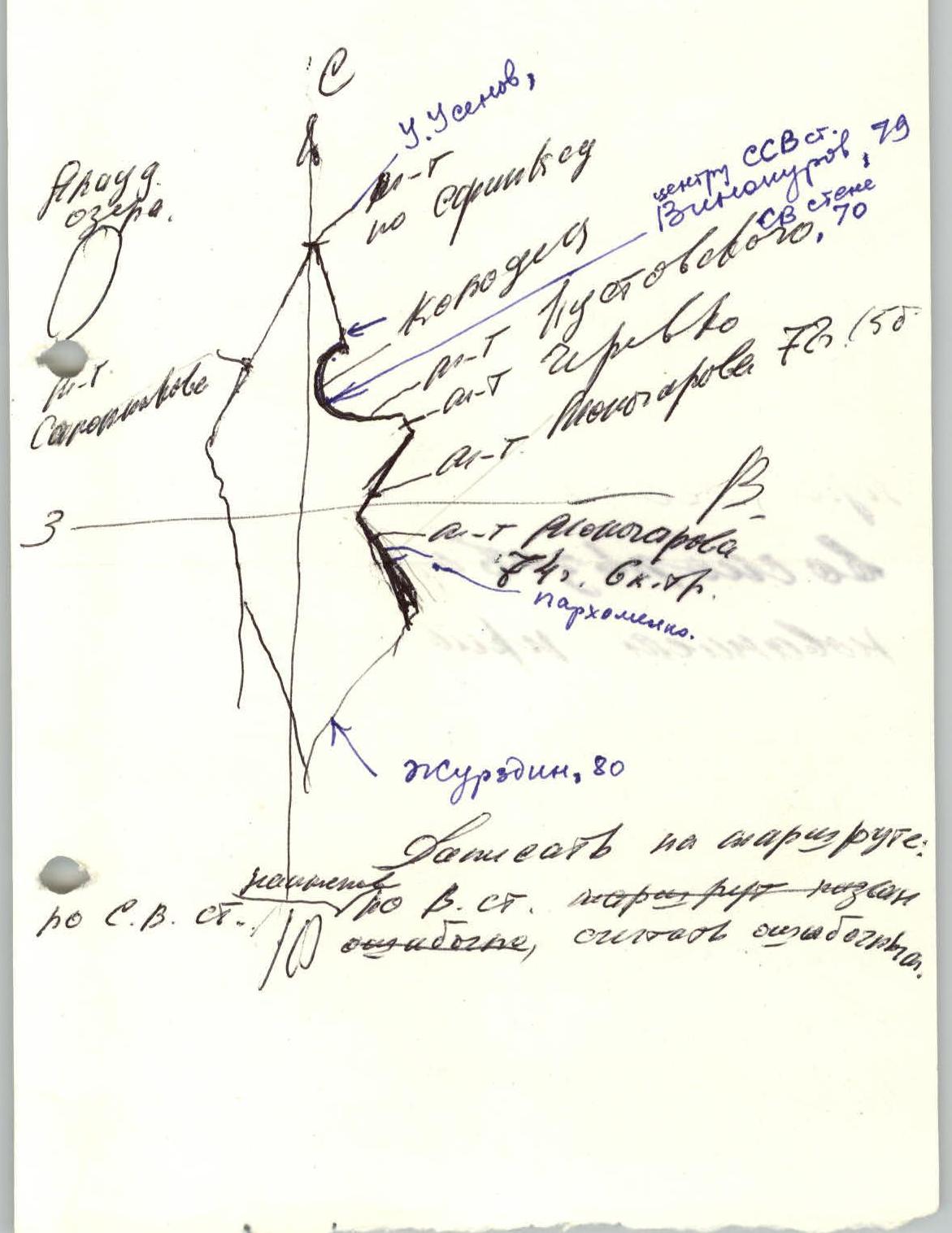
In the center: route of the Mособлспорткомитета team 1979. 1. Route of the Kustovsky group. 2. Route of the “Polytechnic” group, ??. route by V. Vekhter, 84.


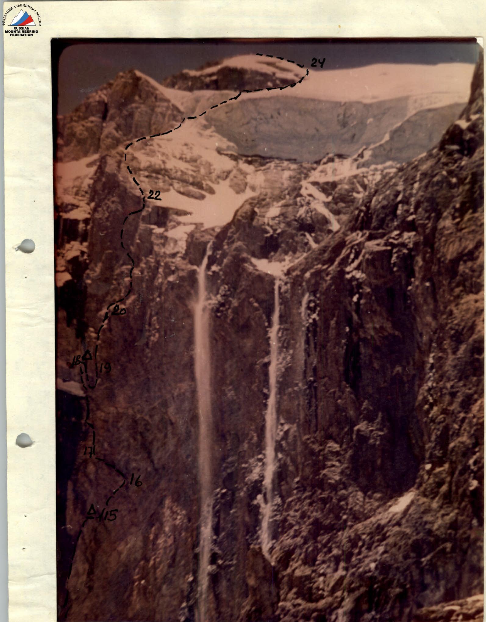
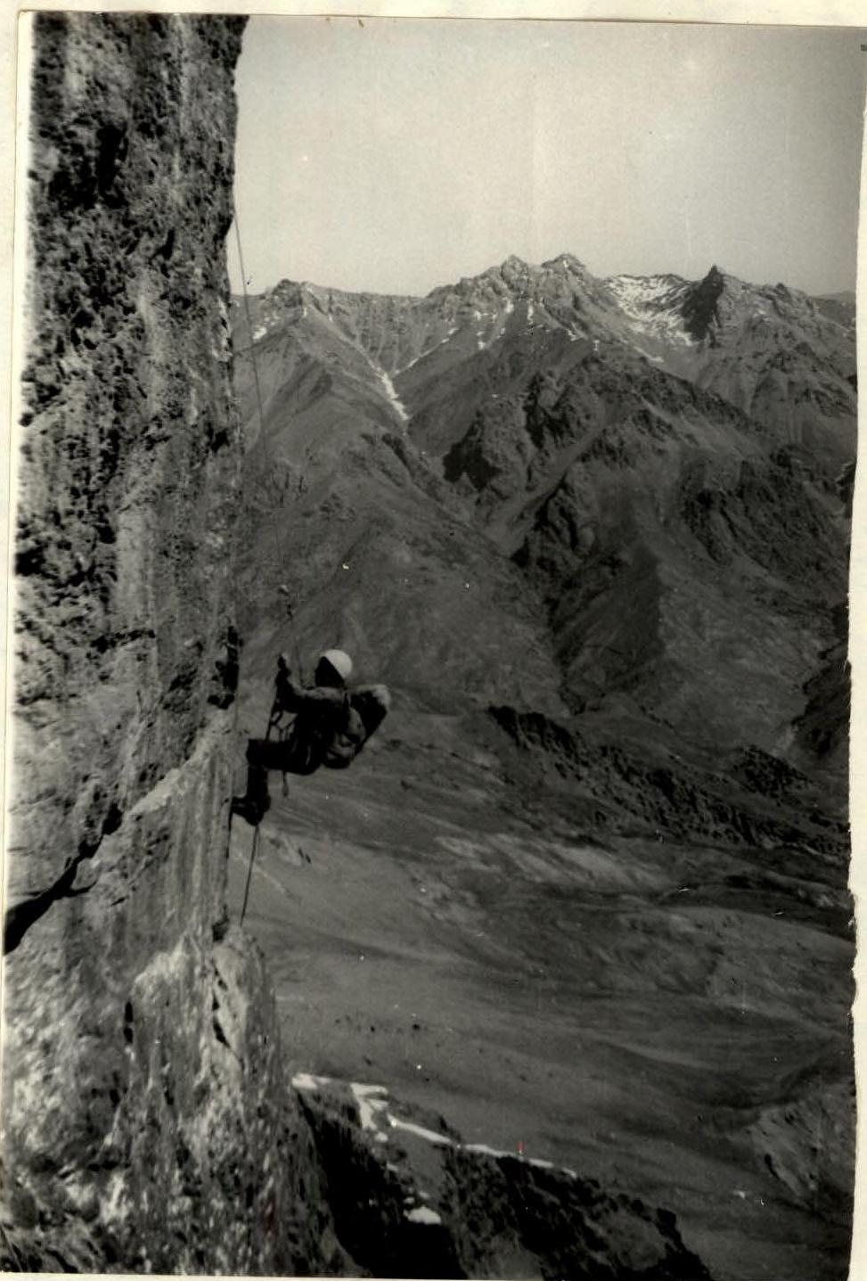
Upper part of the wall in the middle of the day.
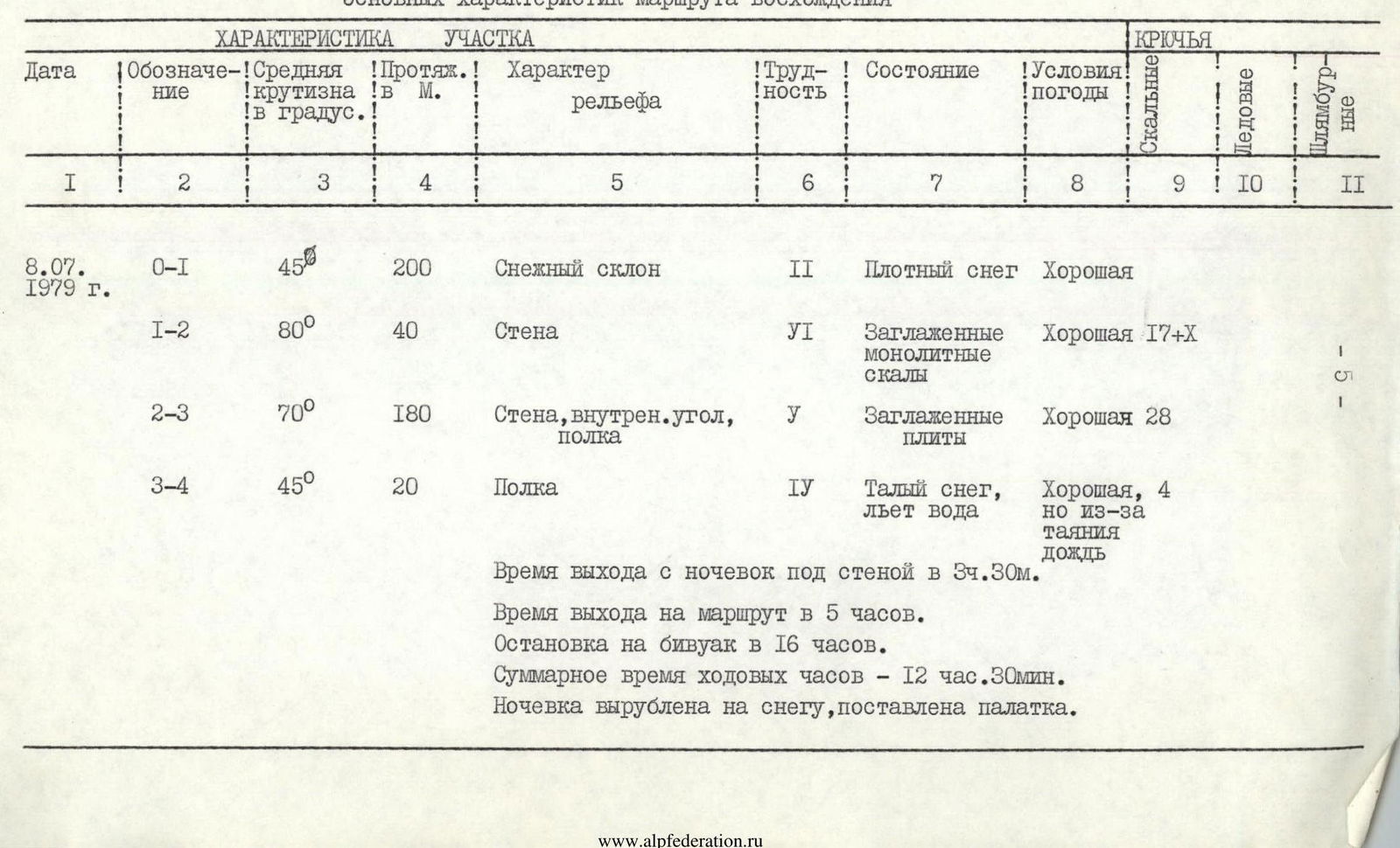
3. Table of main characteristics of the ascent route

Route on the section by S. Smolin, S. Vanapar, Lomakhin, Mogilev Regional Sports School 1974.
| Date | Designation | Average steepness in ° | Length in m | Character of relief | Difficulty | Condition | Weather conditions | Rock pitons | Ice pitons | Bolts |
|---|---|---|---|---|---|---|---|---|---|---|
| July 8, 1979 | R0–R1 | 45 | 200 | Snow slope | 2 | Dense snow | Good | |||
| R1–R2 | 80 | 40 | Wall | 6 | Smoothed monolithic rocks | Good 17+X | ||||
| R2–R3 | 70 | 180 | Wall, inner corner, shelf | 5 | Smoothed slabs | Good 28 | ||||
| R3–R4 | 45 | 20 | Shelf | 4 | Thawing snow, water flowing | Good, 4, but rain due to thawing | ||||
| Departure time from overnight stay under the wall at 3:30 am. Departure time on the route at 5:00 am. Stop for bivouac at 4:00 pm. Total climbing time — 12 h 30 min. Overnight stay dug in the snow, tent pitched. | ||||||||||
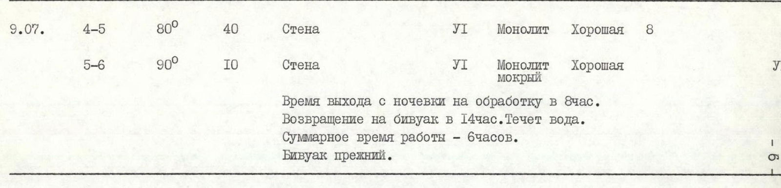
| July 9 | R4–R5 | 80 | 40 | Wall | 6 | Monolith | Good 8 | 6 | ||
| R5–R6 | 90 | 10 | Wall | 6 | Wet monolith | Good | ||||
| Departure time from overnight stay for processing at 8:00 am. Return to bivouac at 2:00 pm. Water flowing. Total work time — 6 h. Same bivouac. | ||||||||||
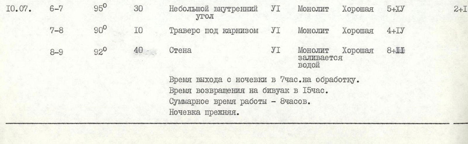
| July 10 | R6–R7 | 95 | 30 | Small inner corner | 6 | Monolith | Good 5+XY | 2+1 | ||
| R7–R8 | 90 | 10 | Traverse under cornice | 6 | Monolith | Good 4+IУ | ||||
| R8–R9 | 92 | 40 | Wall | 6 | Monolith | Good 8+II, flooded with water | ||||
| Departure time from overnight stay at 7:00 am for processing. Return to bivouac at 3:00 pm. Total work time — 8 h. Same overnight stay. | ||||||||||
| July 11 | R9–R10 | 80 | 20 | Wall | 5 | Monolith | Good 4 | 3 | ||
| R10–R11 | 80 | 40 | Wall | 6 | Monolith with water | Good 4+II | ||||
| Departure time from overnight stay at 6:00 am. Stop for bivouac at 9:00 pm. Total climbing time — 15 h. Sitting overnight stay — wet. | ||||||||||
| July 12 | R11–R12 | 70 | 50 | Inner corner | 6 | Wet monolith | Good 6 | 2 | ||
| R12–R13 | 87 | 40 | Wall, inner corner | 6 | Wet monolith | Good II+VII | ||||
| Departure time from overnight stay at 7:00 am. Stop for bivouac at 8:00 pm. Total climbing time — 13 h. Sitting overnight stay in different places, wet. | ||||||||||
| July 13 | R13–R14 | 85 | 40 | Inner corner | 6 | Red rocks with loose stones at 10° | Good 10+II, wet | |||
| R14–R15 | 75 | 30 | Inner corner | 6 | Red rocks with loose stones, wet | Good 6 | ||||
| Departure time from overnight stay at 6:30 am. Stop for overnight stay at 12:00 pm, processing and further route finding. Total climbing time — 5 h 30 min. Good overnight stay, tent pitched. | ||||||||||
| July 14 | R15–R16 | 100 | 40 | Inner corner leading to a large cornice | 6 | Fragmented marble rocks | Good 15+X | 2 | ||
| R16–R17 | 95 | 20 | Cornice, wall | 6 | Fragmented rocks | Good 2+XVI | 1 | |||
| R17–R18 | 80 | 40 | Inner corner | 4 | Wet monolith | Good 5 | ||||
| Departure time from overnight stay at 6:30 am. Stop for bivouac at 8:00 pm. Total climbing time — 13 h 30 min. Good overnight stay, on a shelf, tent pitched. | ||||||||||
| July 15 | R18–R19 | 90 | 20 | Chimney | 6 | Monolith | Good 10 | |||
| R19–R20 | 90 | 40 | Wall | 6 | Monolith | Good 12+У | ||||
| R20–R21 | 70 | 80 | Wall | 5 | Destroyed rocks | Good 12 | ||||
| R21–R22 | 85 | 40 | Wall | 6 | Monolith | Good 7 | ||||
| Departure time from overnight stay at 6:30 am. Stop for bivouac at 11:00 pm. Total climbing time — 16 h 30 min. Semi-reclining overnight stay in different places. | ||||||||||
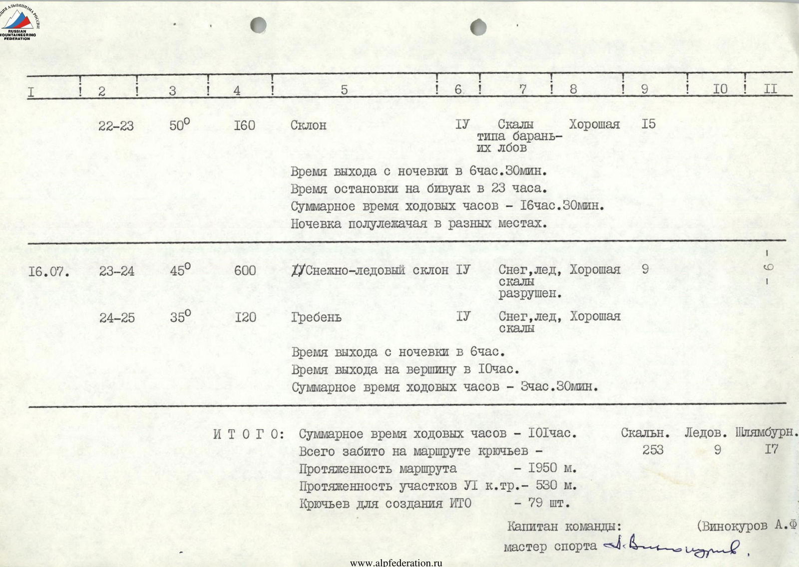
| July 16 | R22–R23 | 50 | 160 | Slope | 4 | Rocks like "ram's foreheads" | Good 15 | 1 | ||
| R23–R24 | 45 | 600 | Snow-ice slope | 4 | Snow, ice, destroyed rocks | Good 9 | 9 | |||
| R24–R25 | 35 | 120 | Ridge | 4 | Snow, ice, rocks | Good | ||||
| Departure time from overnight stay at 6:00 am. Arrival at the summit at 10:00 am. Total climbing time — 3 h 30 min. |
Total: Total climbing time — 101 h. Total pitons hammered on the route: rock — 253, ice — 9, bolted — 17. Route length — 1950 m. Length of sections with VI cat. diff. — 530 m. Pitons for creating artificial points of support — 79 pcs. Team captain: Vinokurov A.F. (Master of Sports)

4. Brief explanation of the table
By the nature of the wall and steepness of the rocks, the route through the center of the Northern wall “KOLODETS” can be divided into five parts.
The first part (sections R1–R3) is a wall with a length of 220 m and a steepness of about 75°. The rocks are monolithic, smoothed, with a small number of holds, gradually transitioning into an inner corner, partially wet.
The second part (sections R4–R12) is a giant delamination with an overhanging section of rocks from 90° to 95°, making this section less passable in free climbing and requiring the use of artificial points of support. The relief of the rocks in this section is even poorer than in the previous one. Passage is possible only along the left part of the giant delamination.
The third part (sections R13–R18) — steep, about 88°, heavily destroyed red rocks. The most difficult area in terms of safety due to the possibility of rockfall — there are areas with very weak rock that can crumble at the slightest touch.

The fourth part (sections R19–R22) consists of 85° steep rocks with overhanging walls and cornices, with poor relief and few cracks for hammering pitons. This greatly complicated the passage of this section and the route as a whole.
The fifth part (sections R23–R25) consists of simple rocks like “ram's foreheads”, transitioning into a snow-ice slope that leads to the summit of Chapdara.
5. Tactics of the ascent
The tactical plan for the ascent provided for the optimal organization of the group's movement based on the reconnaissance of the route and its observation, studying reports of previous ascents on the wall. The tactical plan includes dividing the route into sections with an indication of the overnight stay locations and tactical measures for safe advancement along the route:
- organization of overnight stays,
- movement under cover,
- movement on a double rope,
- use of harnesses and ascenders.
It should be noted that during the passage of the route, the assessment of most of it was correct, and the large number of overhangs and ledges contributed to the correct organization of the tactical plan for safe passage.
The most significant miscalculation was the assessment of the wall's susceptibility to waterlogging (from 10:00 am to 2:00 pm), which affected the group's movement as a whole during the passage. The group had to wait out this time under overhanging walls and cornices.
The character of the participants' movement on the route was in accordance with the tactical plan — movement of all participants only on a double rope with the use of ascenders, harness-ladder on overhanging sections and overhangs without relief, or with pulling up the backpack with a safety rope on simpler relief.
Section R18–R19.
7. Conclusion
The route climbed by the MOS DSO “TRUD” team through the central part of the Northern wall “KOLODETS” is interesting and logical. The route is tense and long, requiring the entire team to have:
- good physical fitness;
- good technical fitness.
The average steepness of the route is about 85°. Technically, the route is complex, requiring careful selection of equipment, mastery of high-level rock climbing techniques, and tactics of modern wall ascents. The entire route is climbed in rubber footwear, galoshes, or “vibram” boots.
There are suitable locations for bivouacs on the route according to the description. Rope hauling was used in the most difficult section.
The climbed route is technically more challenging than all classified routes of the highest category in the Fan Mountains (all of which were climbed by team members in previous seasons).
Given that no route has been laid through the central part of the Northern wall, the route through “KOLODETS” is considered independent and climbed for the first time.
Based on the experience of joint ascents of 5B and 6B cat. diff. in the Caucasus and the Fan Mountains, the team participants believe that the route to the peak Chapdara through the central part of the Northern wall “KOLODETS” corresponds to 6B cat. diff. and can be recommended for groups with sufficient experience in wall ascents of 6B cat. diff.