The route was climbed for the second time.
Ascent Details
- Climbing category
- Climbing region — Pamir-Alay, Fann Mountains
- Ascent route with indication of peaks and their heights: Chapdara peak (5197 m) via the right side of the western wall.
- Ascent characteristics: height difference 5197 – 2730 = 2467 m average steepness 55–60° length of the complex section 60 meters
- Pitons used: rock pitons 70 ice pitons none bolt pitons none
- Number of climbing hours — 18
- Number of nights and their characteristics: one good overnight stay under the route, water available, нависающие скалы страхуют от камнепада ("overhanging rocks protect from rockfall").
- Team name — sports group of the Moscow Region Alpine Federation.
- Participants' names and qualifications: Opoytsev Nikolai Anatolyevich 2nd sports category Kalagin Yuri Grigoryevich 1st sports category
- Team coach — senior instructor Dautov Boris Vladimirovich
- Date of departure and return — 17–18 August 1978
a) Brief geographical description of the climbing region
Between the Gissar and Zeravshan ranges of the Pamir-Alay rises a cluster of short but high ranges — the Fann Mountains. The region has become known relatively recently but has already established itself as very interesting. The peaks of the region — Bodkhona, Chapdara, Zamok, Mirali, Chimtarga, Mariya, Energiya, Zindon, Aurondag, and Rudaki — require enhanced attention and good preparation when climbing. This is a natural phenomenon, as the peaks are mostly traversed by routes of IV–VI difficulty category. The region's exploration began in the 1930s, but it gained significant popularity due to the expeditions conducted by the Kazakh Alpine Club starting from 1966. The Fann massif is a center of significant glaciation: glaciers lie between the spurs of the three main ranges and are mostly concentrated on the northern slopes. The Fann Mountains are characterized not only by high peaks, narrow gorges with noisy streams, but also by numerous lakes that adorn the harsh mountain landscape.
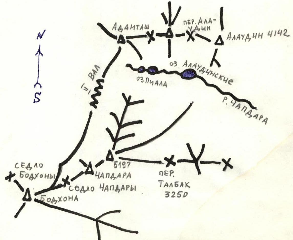
The Chapdara peak is located near the Alaudin lakes, to the southwest. Its height is 5197 m above sea level. (photo 1)
b) Map of the region
 c) Brief description of climbing conditions
The ascent to Chapdara peak was made on 17–18 August 1978. The base camp was located near the foot of the peak (2 hours). Weather conditions were good. No precipitation in the form of rain or snow was observed. Air temperature was positive. At night, the temperature dropped to +5…+8°C. The approach to the peak is made via a clearly visible trail under the western wall glacier. From the Alaudin lakes (base camp), the approach takes 1.5–2 hours. (photo 2)
d) Description of the route
Departure at 17:00. From the Alaudin lakes, the approach takes 1.5–2 hours under the Western wall glacier. Before reaching the glacier, turn right to the rock massif covered with grass at the foot of the "Polytechnic" peak. Moving right and going behind the counterfort of the "Polytechnic" peak via scree, dry glacial stream beds, and rock "steps," maintain direction towards the saddle between Chapdara and the "Polytechnic" peak. (photo 2) To the right of the route, on the slopes of Chapdara under the snowpatch — a safe and convenient place for organizing an overnight stay under нависающими скалами ("overhanging rocks"). Nearby — water sources — from melting glaciers and snowpatch. Water should be prepared for the morning, as glacial melting stops at night. From the base camp at Alaudin lakes to the overnight stay location — 3 hours. Ascent at 6:00 — rope up and immediately ascend 20 m to the snowpatch boundary. Then, move left — and along the boundary of the glacier and moraine, approach the start of the counterfort on a large scree shelf — the upper part of the "large rounded rock" of the counterfort. 1st control point. From the first control point, bypassing rocks on the left and via simple rocks 2–3 ropes, reach a well-equipped site for an overnight stay. Here, groups that depart earlier can organize an overnight stay. (Photo 3) From the overnight stay to the site — 2–2.5 hours. Further:
- along the counterfort,
- via simple rocks and rocks of the next medium difficulty
approach the right (in the direction of travel) side of the "Zmeika" glacier. Insurance via outcrops and pitons. Via internal corners, cracks, simple and medium rocks, approach the key section. From the site — 3–3.5 hours.
Piton insurance.
The key section represents a wall with a slope of 75–80° with a narrow crack-fissure. Height 60–70 meters. There is a convenient site after 110 m of climbing. Climbing is complex, using швеллерные крючья ("channel pitons").
Having passed the key section and still following the right side of the "Zmeika" glacier, ascend to the ridge of Chapdara via medium rocks in the gap between the 1st and 2nd tooth on the ridge of Chapdara.
Photo 1
From the first overnight stay to the ridge — 8–9 hours. Then, bypass the "big Gendarme" on the right via a ledge and further along the ridge to Chapdara peak. After 30 minutes of exiting onto a large scree under the red rocks, rucksacks can be left near the descent trail. In 1–1.5 hours of simple rock climbing or bypassing via scree on the right, ascend to the summit.
Descent to the Bodkhona valley:
- Via scree, bypassing the "rock island" — red rocks encountered on the ascent after the large scree.
- At the end of the season — a descent trail is clearly visible.
After retrieving rucksacks — enter a simple couloir, which is traversed:
- "Sportingly," or
- If the group is small and there is no possibility to throw down ЖИВЫЕ КАМНИ ("live rocks") — descend carefully in a tight group via climbing.
After this, 9 logical rappels (full and incomplete) from one rappel station to another. Descent takes 4 hours.
Further:
- Along the trail to the 2nd valley,
- From it, along the trail to Alaudin lakes.
Recommendations:
- If a group departs at 12:00, an overnight stay can be organized on the counterfort site.
- Channel pitons are mandatory; it is possible to use закладные ("placed protection"). Mandatory spare cordelette for replacement at "rappel" stations. e) Photograph of the ascent object. See p. 7
Observation group composition:
- Karzanov Alexander 1st sports category
- Shatilov Vadim CMS
Observation log is attached.
Table of main characteristics of the ascent route to Chapdara peak via the right side of the Western wall according to the route 5A category of difficulty (approximately)
The route was climbed for the second time.
| Section № | Date | Section characteristics and passage method | Steepness | Section length | Relief | Category of difficulty | Insurance | Weather conditions, time | Rock pitons | Ice pitons | Bolt pitons | Overnight stay conditions |
|---|---|---|---|---|---|---|---|---|---|---|---|---|
| R0 (I-0) | 17 Aug. 1978 | Approach to the overnight stay site under the right part of the wall | 30° | 3 climbing hours | trail, simple step-like rocks | 1 | Simultaneous movement | good, t=+15°C. Departure 17:00, in transit 3 hours | Overnight stay under нависающими скалами ("overhanging rocks") below the glacier. Water available. Conditions good. | |||
| R1–R2 (1-2) | 18 Aug. 1978 | Along the glacier and moraine boundary to the start of the counterfort | 30° | 1.5 climbing hours | ice, ice covered with rubble, rocks | 2 | Step cutting, insurance via outcrops | good. Departure 6:00, in transit 2 hours | ||||
| R2–R3 (2-3) | 18 Aug. | Exit onto the counterfort, 1st control point | 45–50° | 2 ropes (40 m) | difficult rocks, crack-fissure with jams | 4 | Pitons insurance | good, t=+18°C | 9 | |||
| R3–R4 (3-4) | 18 Aug. | Along the counterfort to the site (via crack-fissure) | 40–50° | 3 ropes | simple and medium difficulty rocks. 2 chimneys | 3 | Pitons insurance | 1 hour | 5 | |||
| R4–R5 (4-5) | 18 Aug. | Along the counterfort to the key section | 50–60° | 6 ropes | medium difficulty and difficult rocks. Internal corners, walls up to 10 m, live rocks | 5 | Pitons insurance | 3.5 hours | 32 | |||
| R5–R6 (5-6) | 18 Aug. | Key section | 75–80° | 2 ropes | very difficult rocks. Use of ladders | 5 | Pitons insurance on carabiners, ladder | 2.5 hours | 27 | |||
| R6–R7 (6-7) | 18 Aug. | Exit onto the ridge | 50–60° | 6 ropes | scree, simple and medium rocks. medium difficulty | 4 | Pitons and outcrop insurance | 1.5 hours | 10 | |||
| R7–R8 (7-8) | 18 Aug. | Along the ridge to the summit | 30–50° | hours | scree, simple and medium rocks | 2 | Non-simultaneous movement, insurance via outcrops | 2 hours |

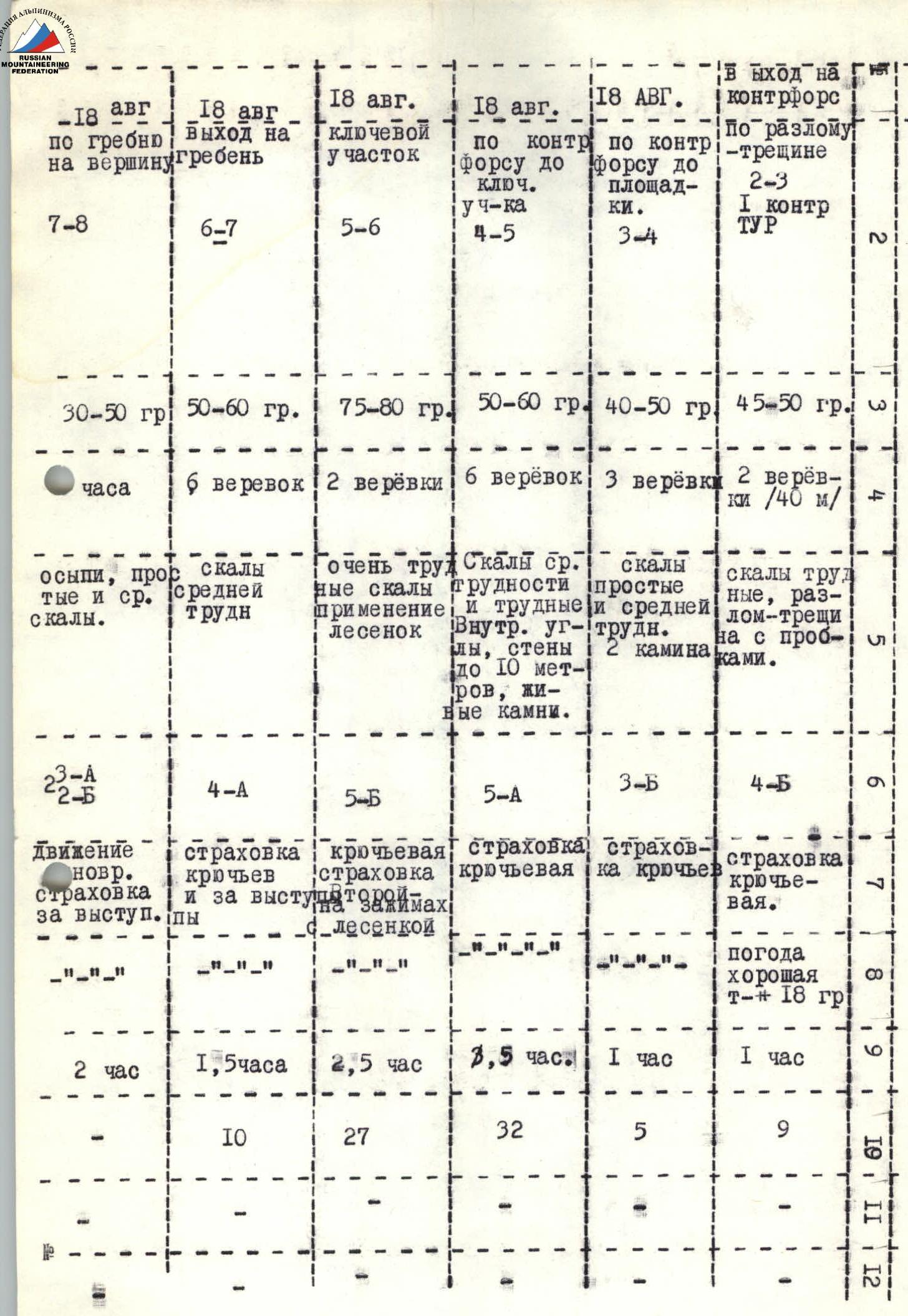
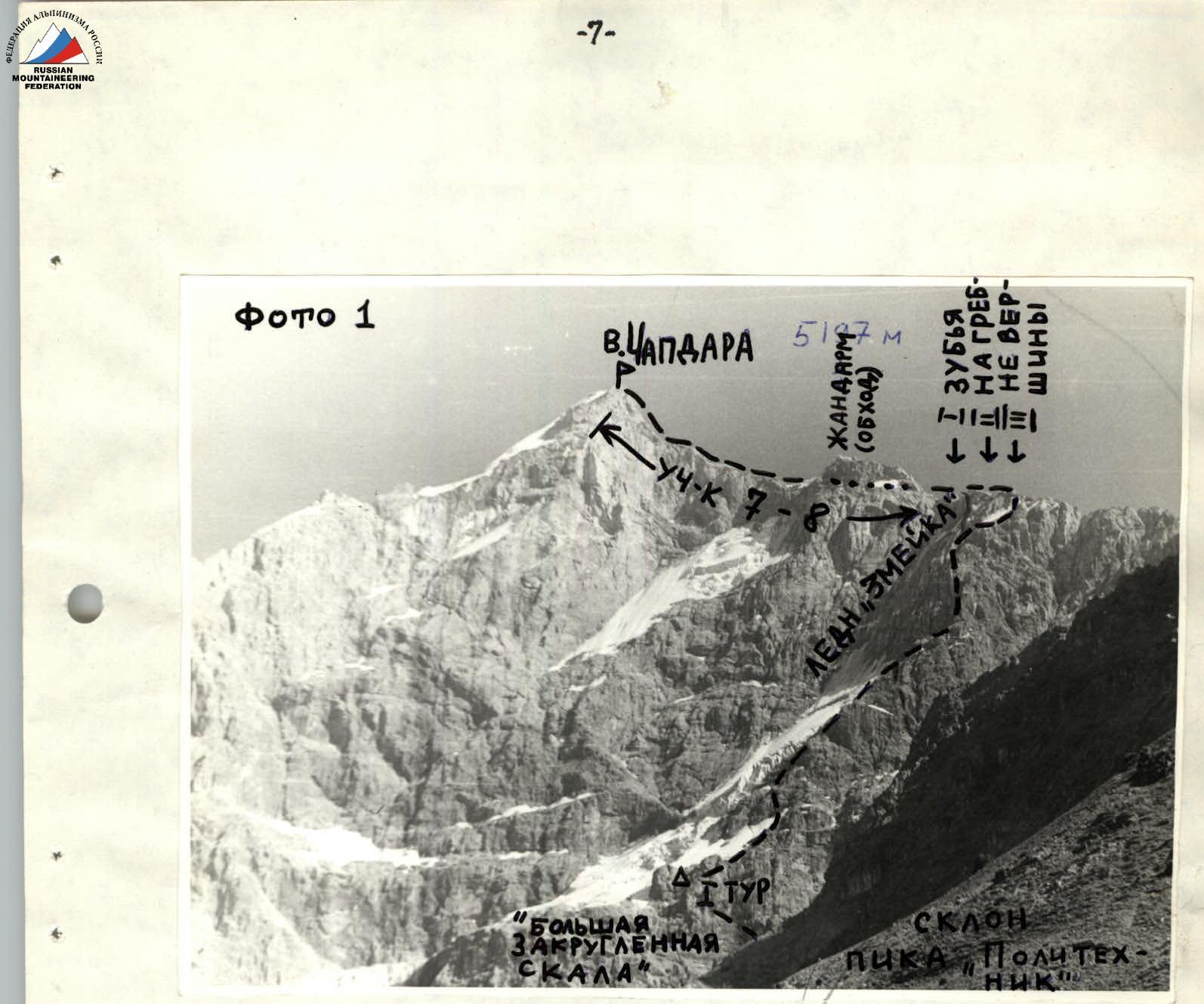 Photo 1
Photo 2
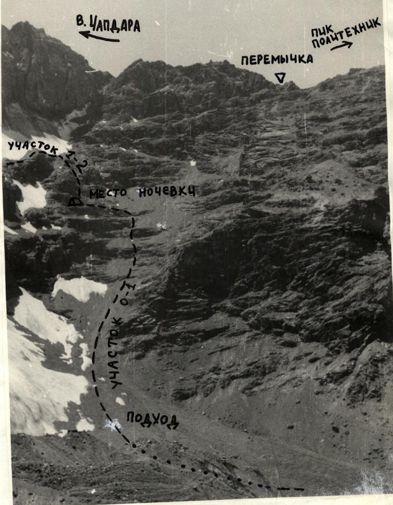
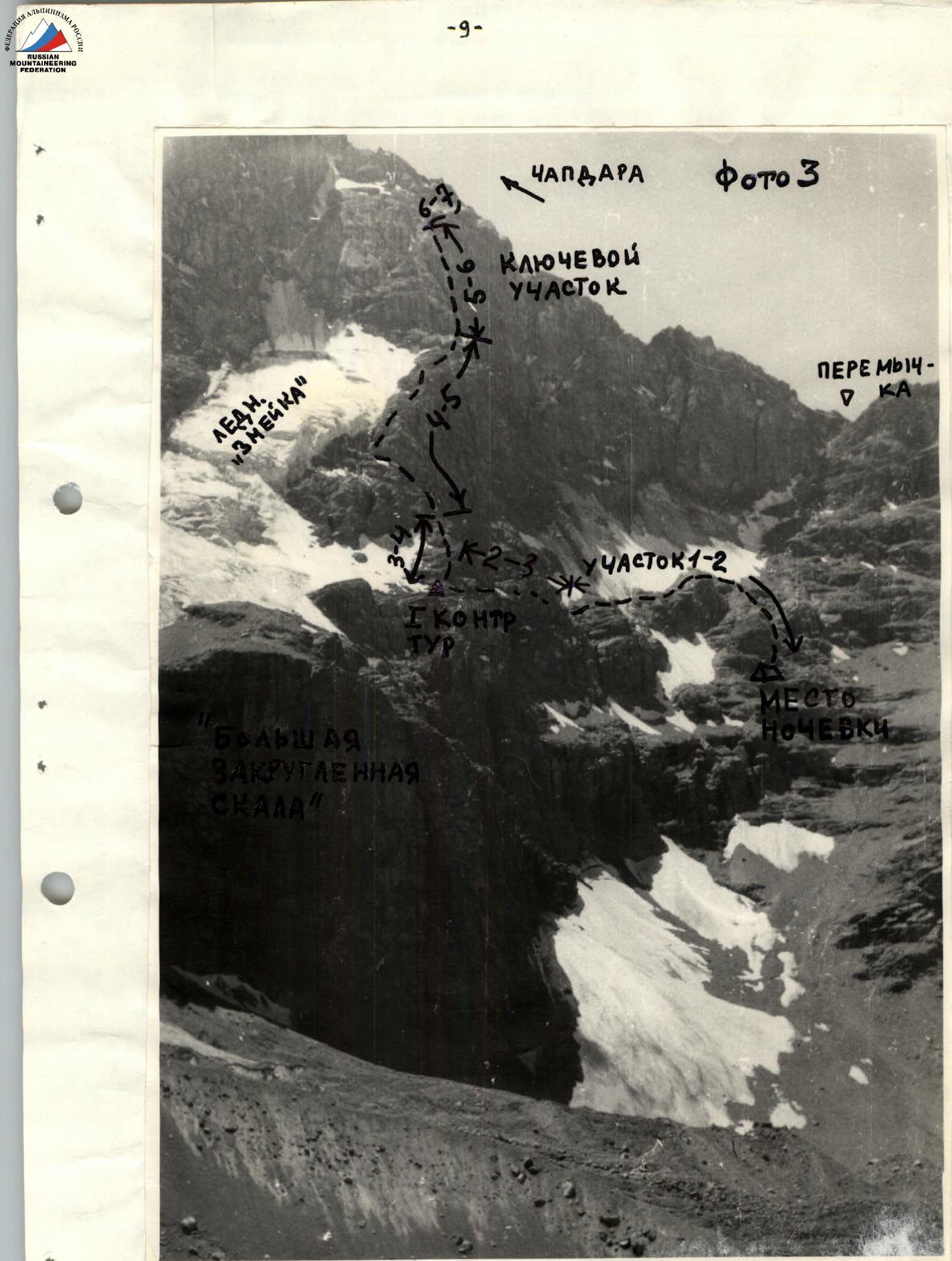 Photo 3