Brief description of the route approach:
- From the base camp at Alaudin lakes, follow the trail to Mutnye lakes (3 hours).
- From the overnight stay at Mutnye lakes, ascend via the scree couloir (snowy at the beginning of summer), to the left of the Fagitor peak wall, to the level of large snow shelves - 20-30 minutes.
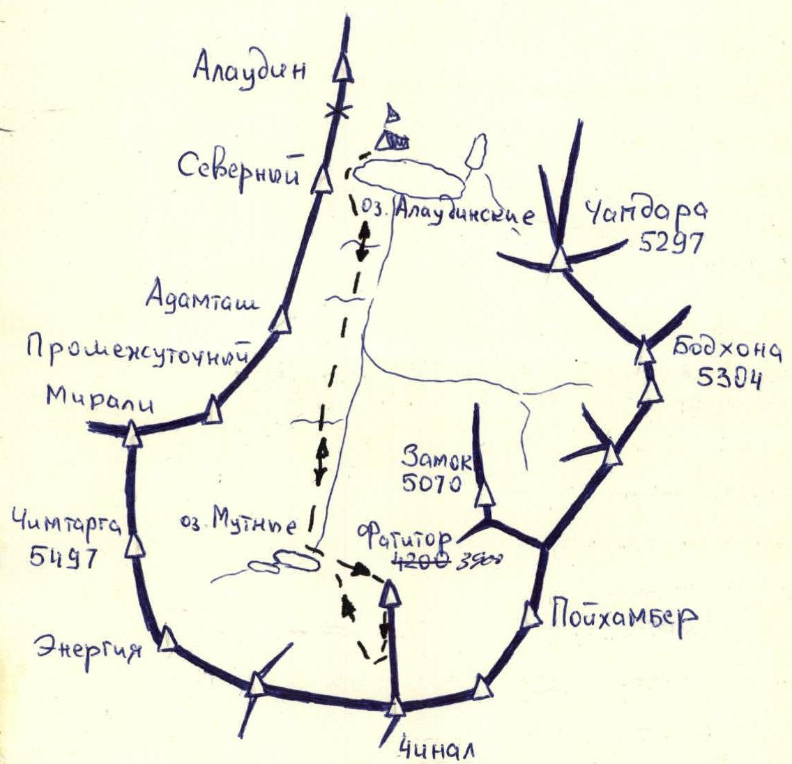
Map of the ascent area
700 m, 2/25, 45° slope, 29 cm, 10 hours.
9/11-797. 15. Sazanov +5 people (1B)
Table of main characteristics of the ascent route
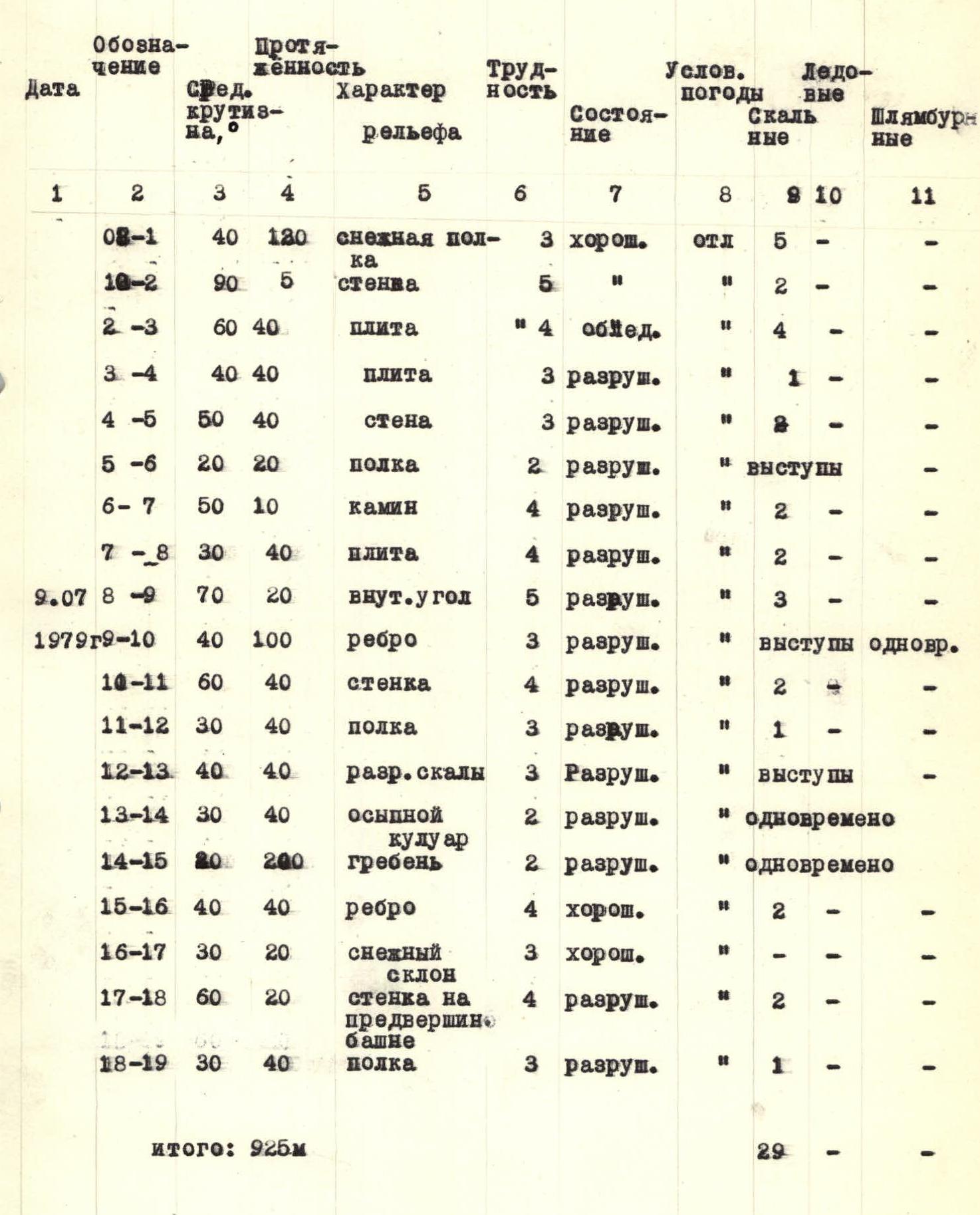
Brief explanation for the table
Sect. R0–R1. From the ascent couloir, exit to simple rocks onto a large snow shelf (lower). Traverse right along it (steepness) for up to 40 m under an отвесной стеной (piton belay) to the end of the shelf. R1–R3. Ascend the vertical wall (piton belay), then traverse right into the inner corner. R2–R3. Ascend 3 m to exit onto an inclined slab with huge boulders on it. Bypass them on the right (piton belay). The slab is covered with flow ice. Behind the boulders, ascend up-right onto a large shelf. Here is the control cairn. R3–R4.
From the control cairn:
- R3–R4. Ascend (2–3 m) and then along the inclined shelf to the right. Exit onto broken rocks.
- R4–R5. Ascend broken rocks vertically up to a shelf under the rusty wall.
- R5–R6. Along the shelf to the left to the inner corner (it's not worth going right onto the ridge - very broken rocks).
- R6–R7. Ascend the inner corner to an inclined slab going up-right.
- R7–R8. Ascend the slab to the ridge (small shelf).
- R8–R9. From the shelf, ascend left-up along a steep inner corner (chimney) clogged with rocks (partially overhanging). Exit onto a large talus shelf.
- R9–R10. From the shelf, exit right onto the edge and then move up simultaneously along the edge to a steep ascent.
- R10–R11. The ascent is overcome head-on; then move right in a screw motion along a sheer wall with a slit. Exit onto a shelf.
- R11–R12. Along the shelf, move left-up under the red wall.
- R12–R14. Behind the red wall, ascend right-up onto the ridge and exit into a talus couloir. The talus couloir leads to the north-west ridge of Fagitor peak.
- R14–R15. Simultaneous movement along the ridge (1 hour).
- R15–R17. Ascend under the pre-summit tower along a not-steep rocky edge. From it, move left-up onto a snow patch. Ascend the snow patch to the tower.
- R17–R18. Ascend steep broken rocks right-up.
- R18–R19. Bypass the tower on the right along a shelf. Then left-up onto the summit.
Descent:
- Along the South ridge (Closed traverse) to the pass between Fagitor peak and Chinal peak.
- From the pass, it's possible to descend left and right to Mutnye lakes, bypassing Fagitor peak (1.5-2 hours).