Ascent Passport
- Ascent class — rock climbing.
- Ascent area — Zarafshan Range, Fann Mountains,
- Summit — Timur, 3900 m, via the eastern ridge, from Zapadny Kitudak Pass, new route.
- Proposed difficulty category — 3B.
- Route characteristics: elevation gain — 300 m; average slope — 45°; route — combined.
- Pitons hammered in:
- for belaying: rock — 12, chocks — 4, ice screws — 8.
- For artificial climbing aids — none.
- Duration of ascent — 9 hours.
- Number of bivouacs — none.
- Leader — Mumdzhi T.M. — Master of Sports of the USSR
- Team members: Chernenko I.I. — 2nd sports category, Morgunov P.A. — 3rd sports category, Grebenkin V.G. — 3rd sports category
- Team coach — Mumdzhi T.M., Master of Sports of the USSR, 1st category instructor
- Date of departure — August 28, 1983 Date of return — August 28, 1983

Photo 3. Technical photograph of the route. Taken on July 9, 1991 at 11:00 with a "Smena Simvol" camera and a T-43 lens with a focal length of 40 mm. Distance to the object — 1.5 m. Height of the shooting point — 3400 m.
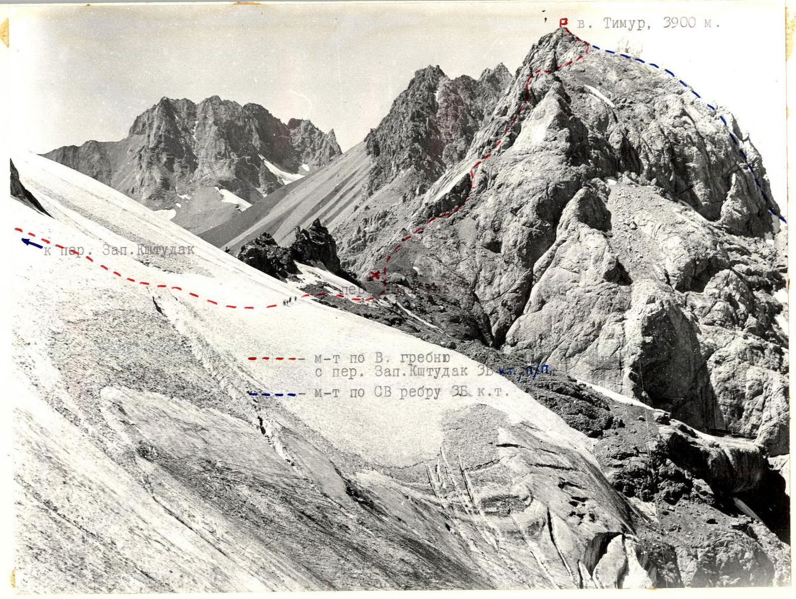
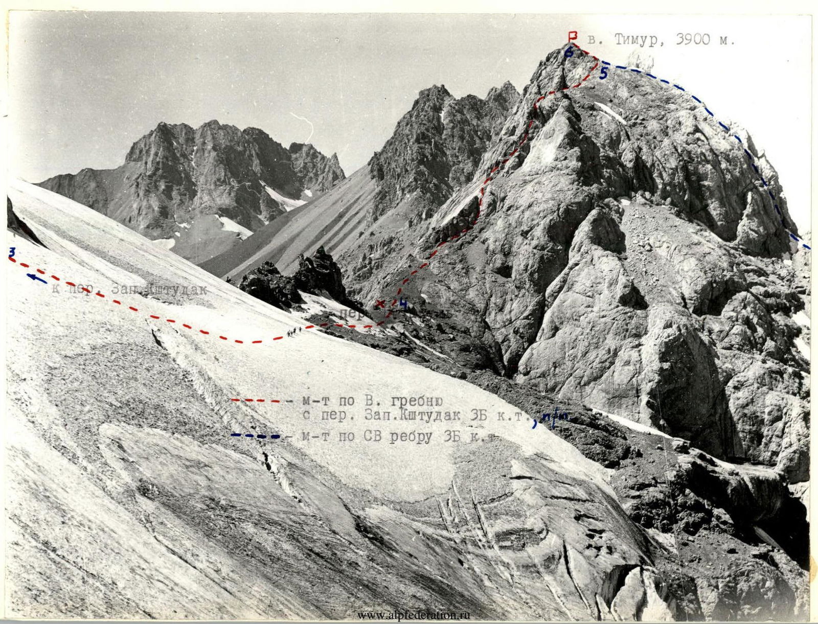
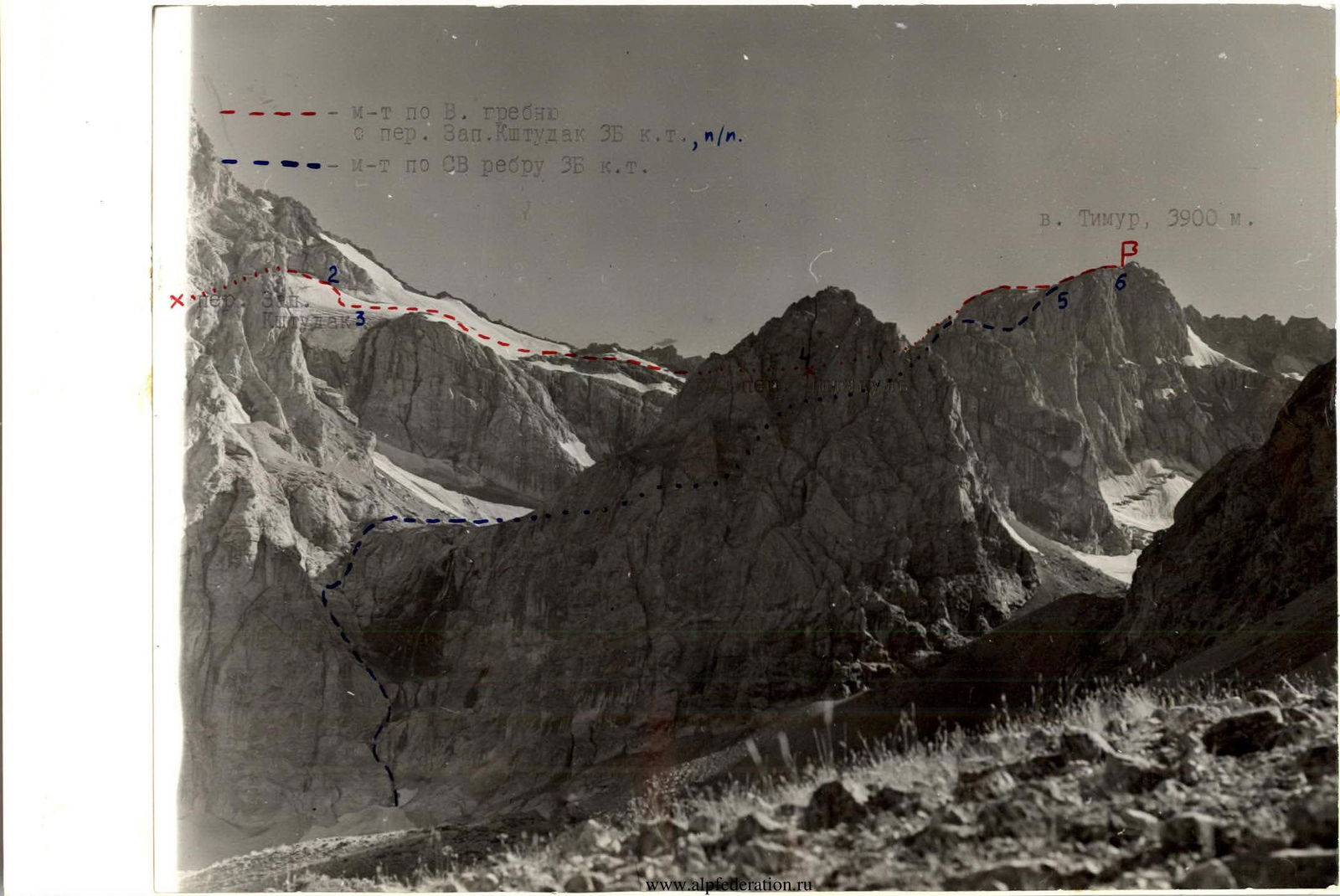
Mt. Timur, 3900 m. To Zap. Kitudak Pass — Route via E. ridge from Zap. Kshutdak Pass 3B difficulty category. — Route via NE edge 3B difficulty category.
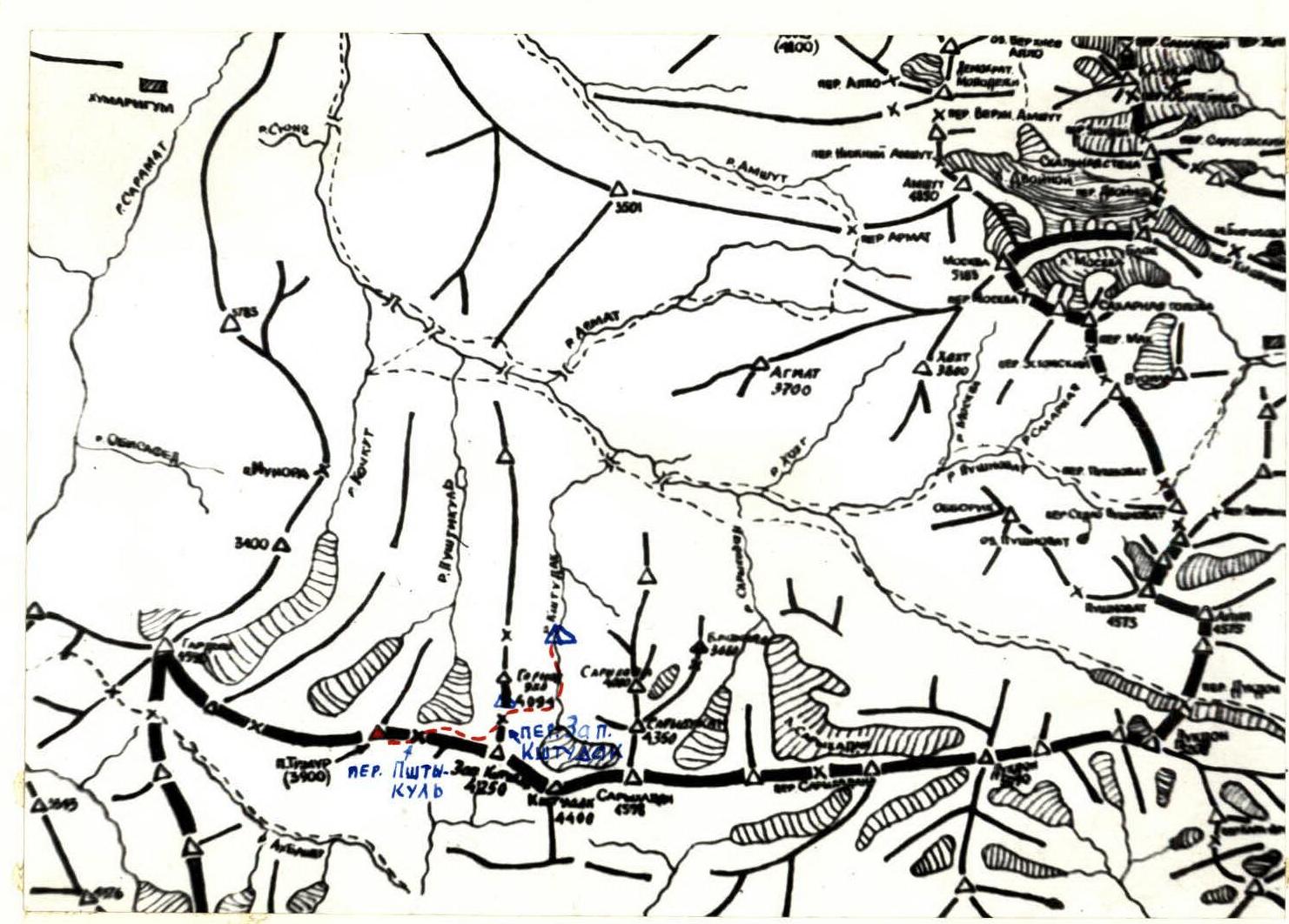
MAP OF THE ASCENT AREA
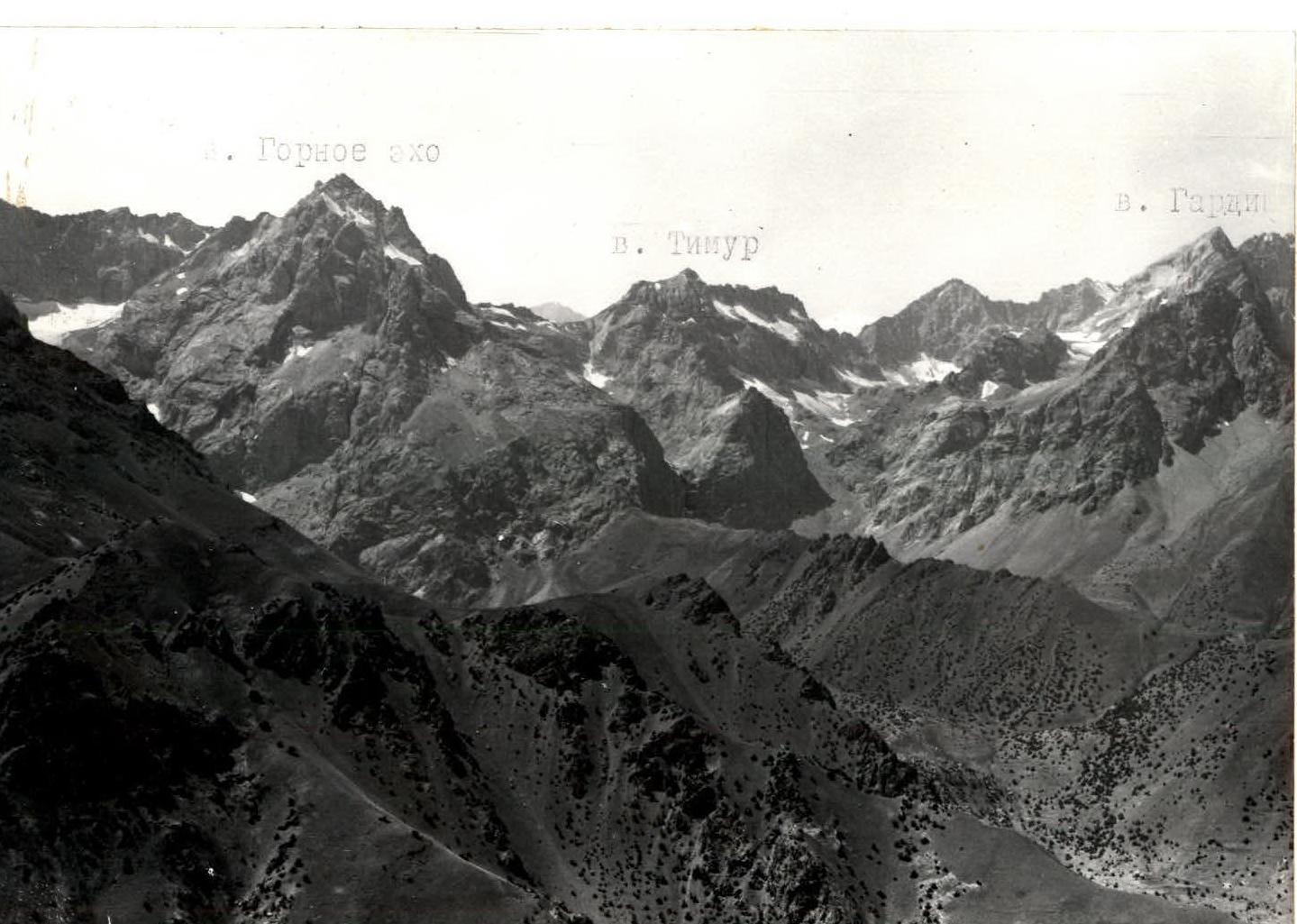
PHOTOPANORAMA OF THE ASCENT AREA (view from the north).
Mt. Timur, 3900 m. To Zap. Kshutdak Pass — Route via E. ridge from Zap. Kshutdak Pass 3B difficulty category. — Route via NE edge 3B difficulty category.
Mt. Timur, 3900 m. — Route via E. ridge from Zap. Kshutdak Pass 3B difficulty category, new route. — Route via NE edge 3B difficulty category.
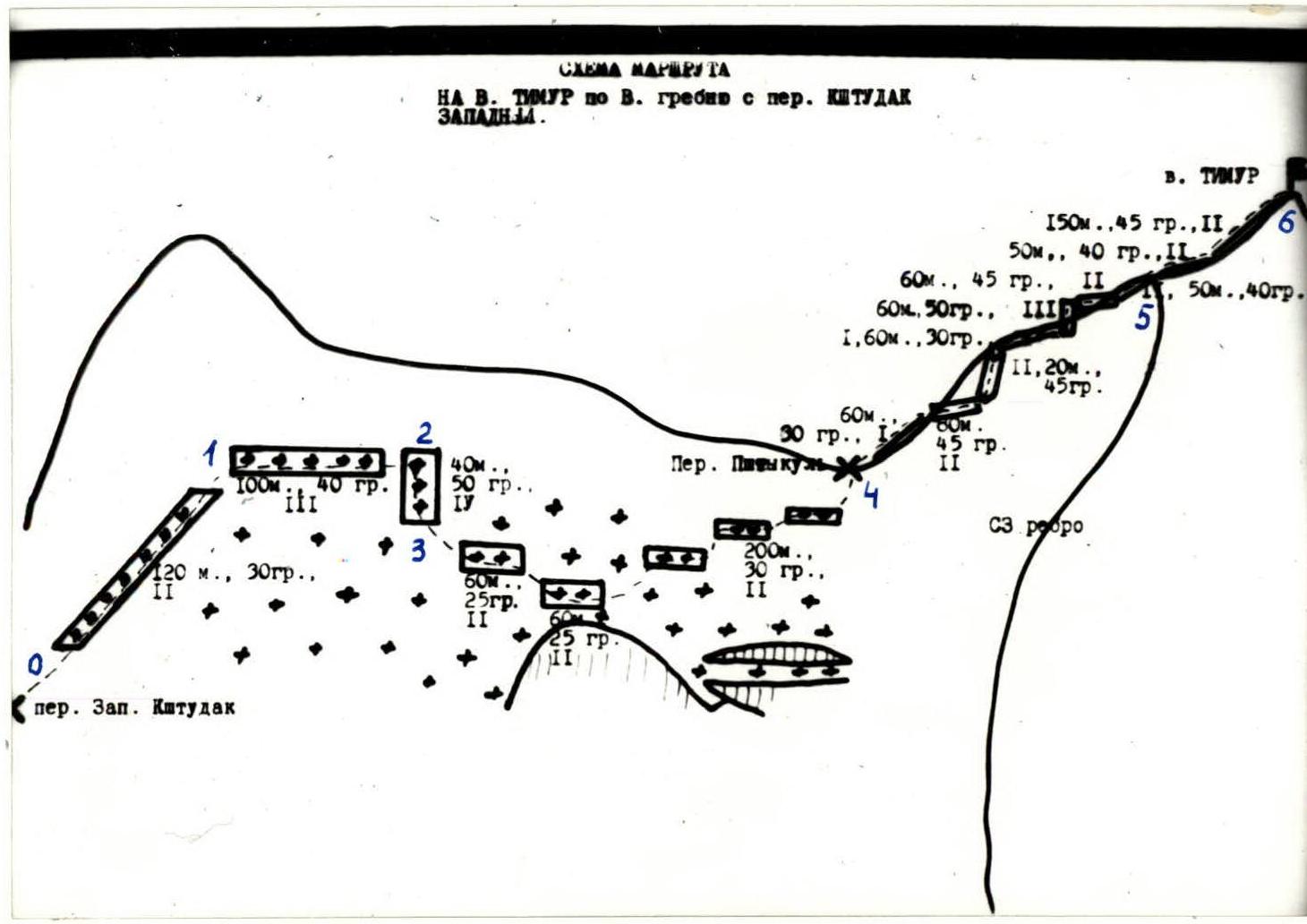
ASCENT ROUTE DIAGRAM IN UIAA SYMBOLS.
Brief description of the route
Ascent (and approach)
From the base camp on the Kshutdak River, up the gorge to the "ram's foreheads" (45 min), after overcoming which, we enter the Kshutdak glacier cirque (30 min).
Then, to the right along the glacier and through the lateral moraines, we come to a steep talus slope. Adhering to the base of the southern slopes of Mt. Gornoe Ekho, we ascend to Zapadny Kshutdak Pass (2 hours).
On the pass — a bivouac. From Zap. Kshutdak Pass, up to the left along the snow-ice slope to the rocks of the watershed ridge, leading through Pshtykuly Pass to Mt. Timur (R0–R1).
Then, to the right along the boundary of rocks and snow-ice slope (R1–R2), belay via rock and ice screws.
After 100–120 m, along a steep ice slope, descend down to the flat part of the glacier (R2–R3). Belay on the section is via pitons.
Then, along the ice-firn slope, sometimes via rock outcrops and "ram's foreheads", we reach Pshtykuly Pass (R3–R4). This section is mostly traversed simultaneously.
Along the destroyed rocks of the eastern ridge (rocks are not difficult, mostly 2nd, sometimes 3rd class), we ascend to the summit (R4–R6).
Descent from the summit and return to Zapadny Kshutdak Pass — in the reverse direction.
Table of main route characteristics
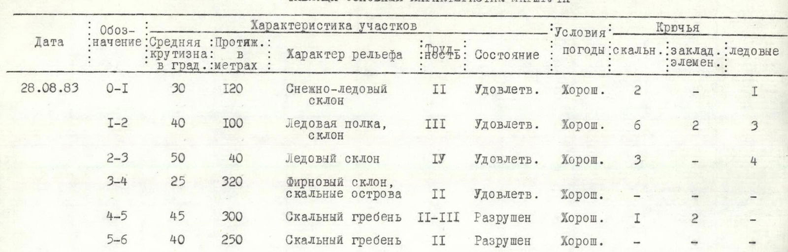
| Date | Designation | Average slope in degrees | Length in meters | Relief characteristics | Difficulty | Condition | Weather conditions | Rock pitons | Chocks | Ice screws |
|---|---|---|---|---|---|---|---|---|---|---|
| 28.08.1983 | R0–R1 | 30 | 120 | Snow-ice slope | 2 | Satisfactory | Good | 2 | 1 | |
| R1–R2 | 40 | 100 | Ice ledge, slope | 3 | Satisfactory | Good | 6 | 2 | 3 | |
| R2–R3 | 50 | 40 | Ice slope | 4 | Satisfactory | Good | 3 | 4 | ||
| R3–R4 | 25 | 320 | Firn slope, rock outcrops | 2 | Satisfactory | Good | ||||
| R4–R5 | 45 | 300 | Rock ridge | 2–3 | Destroyed | Good | 1 | 2 | ||
| R5–R6 | 40 | 250 | Rock ridge | 2 | Destroyed | Good |