Ascent Log
- Ascent class - technical
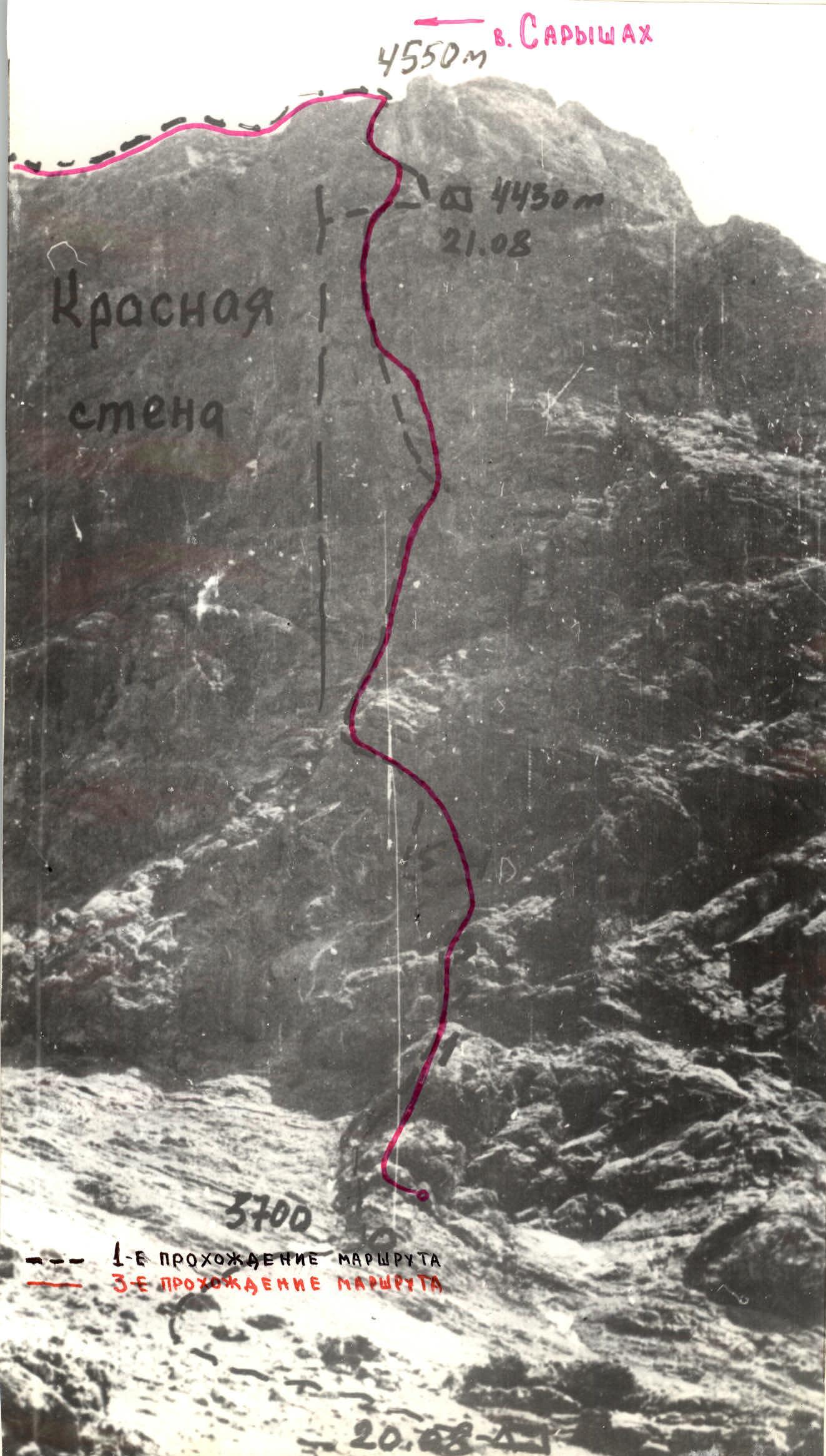
- Ascent area, ridge - Zarafshan Ridge, Fann Mountains.
- Peak, its height, ascent route:
Saryshah, 4650 m, via the right part of the NW wall, 5B category difficulty, 3rd ascent of the route.
- Proposed difficulty category - 5B.
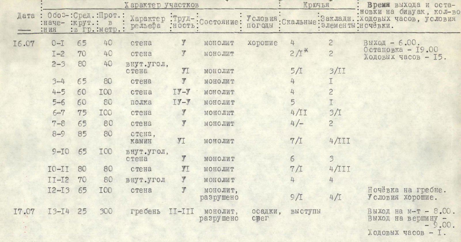
- Route characteristics:
height difference - 950 m, length of sections with 5-6 category difficulty - 800 m, average steepness - 76°.
- Pitons hammered:
rock - 72, including 7 for creating belay stations, chockstones - 45, including 10 for creating belay stations.
- Number of climbing hours - 16.
- Number of bivouacs and their characteristics:
one bivouac - comfortable, on a ridge.
- Participants' full names and qualifications:
Dronov K.Z. - Candidate Master of Sports, Babeshko V.P. - Candidate Master of Sports.
-
Team coach: Mumdzhi T.M., Master of Sports of the USSR, 1st category instructor-methodologist.
-
Date of departure and return:
departure - July 16, 1980, return - July 17, 1980.
Main Route Characteristics
Brief Explanation
To the table
The approach to the route from the "Artuch" tourist center via the Diamar pass takes 7-8 hours.
The route starts immediately up the wall to the right of the couloir, which separates the route from the large red wall, via a clearly defined rock ledge. To the left is a snow-firn slope at the base of the red wall.
Up the rock ledge via steep, complex rock. In some places, the sections are completely vertical and have overhangs (R0-R3).
Then via steep, slab-like rocks, first up, then left to the base of the left part of the "pudding" rock (R3-R6). On the ledge is cairn #1.
Then: vertically up the wall (via the left part of the "pudding") and right via the couloir, which leads to the base of a sheer inner angle - a chimney, broken in the lower third by a rock ledge.
Here, on the ledge, is cairn #2 (R6-R9). Climbing is very challenging.
The chimney leads to the base of the steep "rusty" wall. From here, left and up, then via the inner angle, then via gray rocks right and up to the base of the large, steep, light-colored wall, clearly visible from below (R9-R12).
Left, bypassing the white wall, then up via a series of inner angles - exit to the pre-summit ridge (R12-R13). Here, a bivouac is organized.
Along the ridge with alternating belays via ledges, in some places simultaneously, exit to the summit.
Descent from the summit via the eastern ridge on a 4A category difficulty route. The height difference of the wall section of the route is about 800 m. Technically, this route is a complex ascent. There are many sheer walls and overhanging sections, passage of which requires both high free climbing technique and the use of artificial support points.
In the direction taken, and the group as a whole followed the path of the first ascendants, the route is safe.