Report
on the ascent made by the team of a/c "Odessa" to the summit of Parandas via the right part of the North face — first ascent.
Ascent Passport
- Pamir-Alay. Zeravshan range. Fan Mountains. March 5, 1988
- Mt. Parandas 4250 m
- First ascent via the right part of N face 6A
- Route type: rock
- Height difference of the route: 850 m Route length: 1370 m. Section lengths:
- V cat. diff. – 280 m
- VI cat. diff. – 340 m
- Average steepness: main part of the route – 80°, total route – 60°.
- Used on the route: pitons: 172
- chocks: 143
- bolted pitons: 16
- skyhooks: 37
- Team's climbing hours: 50 h, 6 days
- Leader: Lavrenenko A. MS Team members:
- Tsushko T.
- MS Maksimenko S., 1st sports category
- Coach Gorbenco M.M. MSM, HST
- Departure to the route: August 3, 2012, 5:30 am Summit reached: August 8, 2012, 10:40 am Return to Base Camp: August 8, 2012, 4:50 pm
- Organization: a/c Odessa

Parandas 4250 m
North face
4250 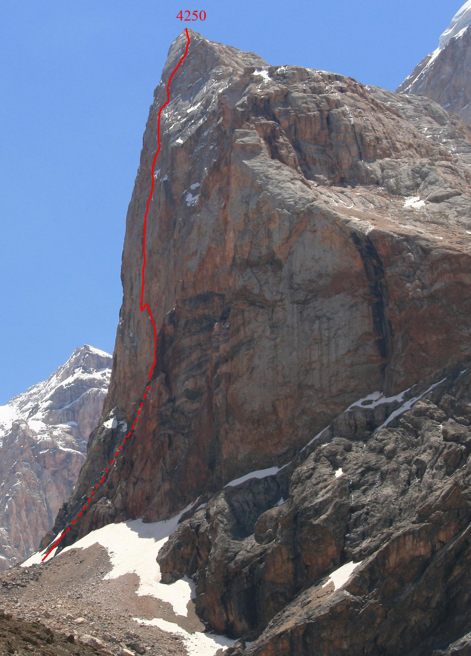 Parandas profile
 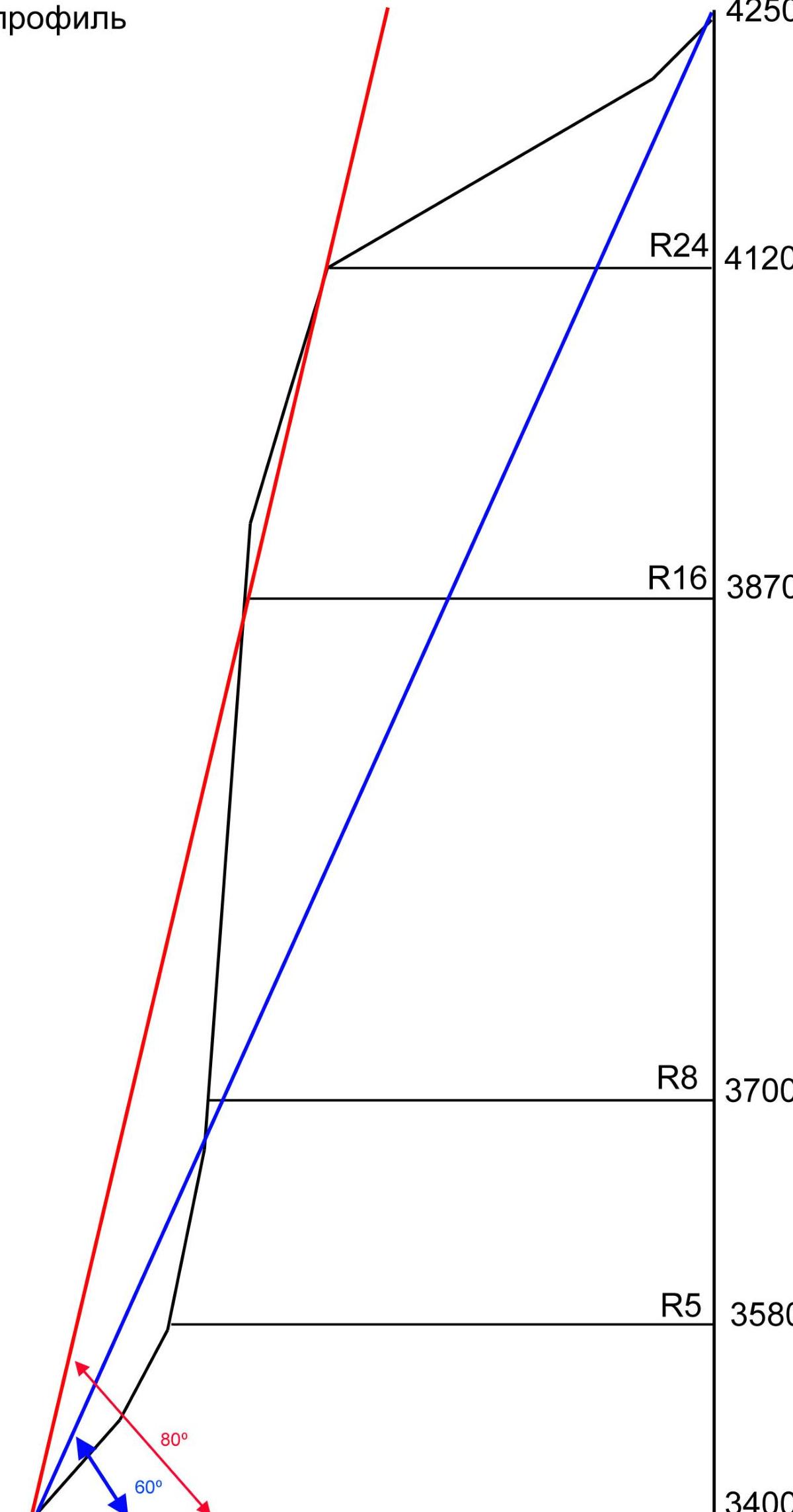 to R26
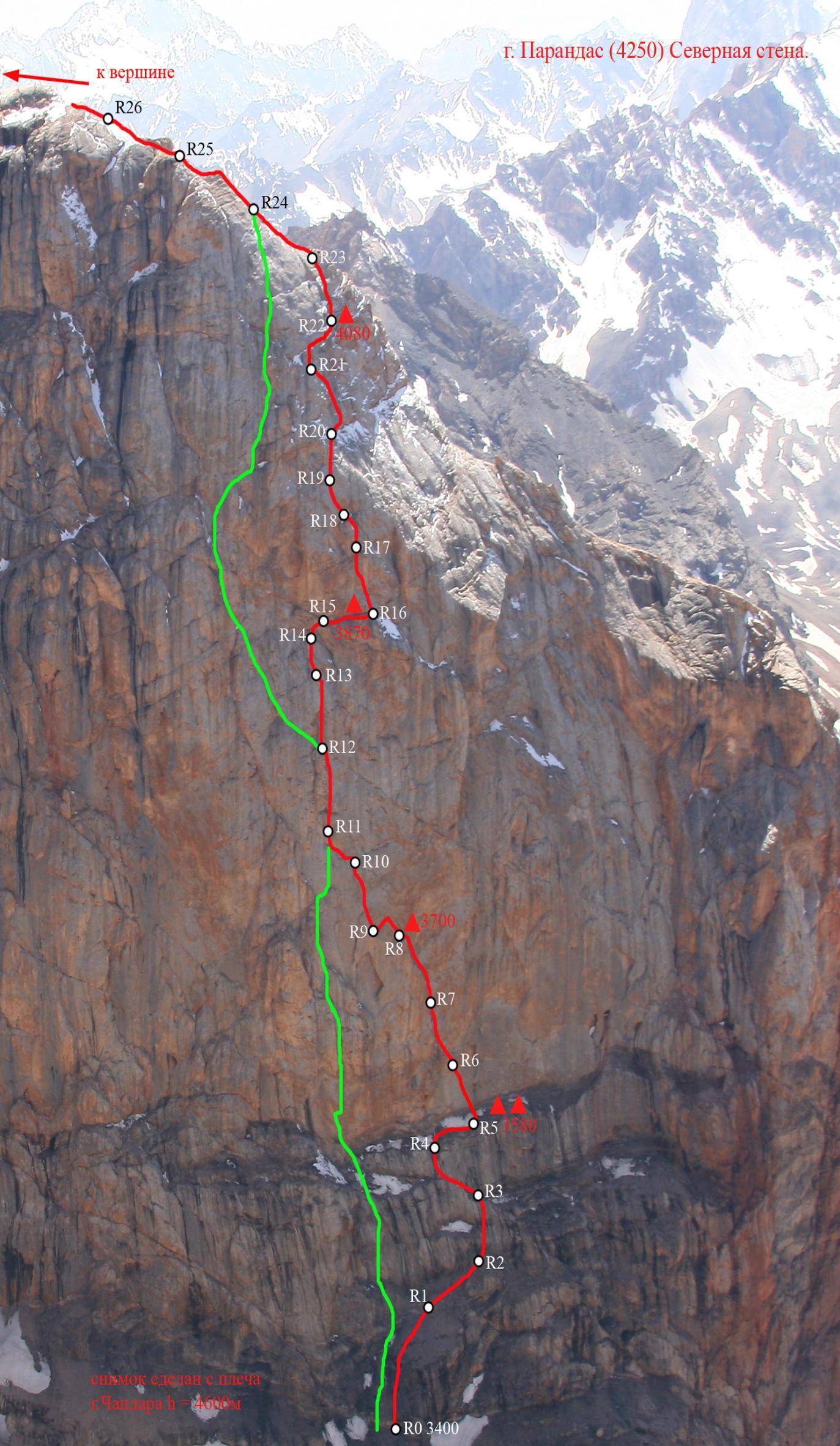
| Section | Length (m) | Steepness (°) | Difficulty | Pitons | Chocks | Skyhooks | Bolted Pitons |
|---|---|---|---|---|---|---|---|
| R0–R1 | 60 | 50 | 1 | 3 | 0 | 0 | 0 |
| R1–R2 | 50 | 60 | 2 | 3 | 0 | 0 | 0 |
| R2–R3 | 50 | 60/70 | 3, 5 (A1) | 6 | 7 | 0 | 0 |
| R3–R4 | 50 | 65 | 3, 4 | 3 | 5 | 0 | 0 |
| R4–R5 | 30 | 45 | 2 | 4 | 0 | 0 | 0 |
| R5–R6 | 40 | 75 | 3, 6 (A3) | 8 | 3 | 7 | 2 |
| R6–R7 | 40 | 85 | 5, (A2e) | 4 | 5 | 10 | 3 |
| R7–R8 | 50 | 75 | 5, 6 (A2) | 2 | 10 | 0 | 1 |
| R8–R9 | 25 | 85 | 6 (A2) | 8 | 5 | 0 | 1 |
| R9–R10 | 50 | 85 | 5, 6 (A3) | 12 | 6 | 8 | 2 |
| R10–R11 | 30 | 70 | 3+, 5 (A2e) | 2 | 4 | 4 | 1 |
| R11–R12 | 55 | 85 | 5 | 5 | 12 | 0 | 0 |
| R12–R13 | 45 | 85 | 6, (A3), 5 | 12 | 8 | 0 | 1 |
| R13–R14 | 30 | 70 | 5 | 9 | 8 | 0 | 0 |
| R14–R15 | 20 | 95 | 6 (A2) | 8 | 1 | 4 | 1 |
| R15–R16 | 55 | 15/50 | n/k, 3 | 2 | 1 | 0 | 0 |
| R16–R17 | 50 | 85 | 5, 6 (A3) | 17 | 4 | 0 | 2 |
| R17–R18 | 25 | 65 | 5 | 7 | 8 | 0 | 0 |
| R18–R19 | 45 | 75 | 5, 6 (A1) | 6 | 10 | 0 | 0 |
| R19–R20 | 40 | 70 | 4, 6 (A2) | 11 | 6 | 0 | 0 |
| R20–R21 | 50 | 70 | 2, 6 (A2) | 12 | 10 | 0 | 0 |
| R21–R22 | 50 | 60 | 4 | 7 | 6 | 0 | 0 |
| R22–R23 | 50 | 70 | 3, 5, 6 (A2) | 12 | 8 | 0 | 0 |
| R23–R24 | 50 | 55 | 4, 3 | 4 | 3 | 0 | 0 |
| R24–R25 | 55 | 50 | 2 | 2 | 4 | 0 | 0 |
| R25–R28 | 285 | 40 | 2 | 3 | 12 | 0 | 0 |
Route description by sections
The route passes through the right part of the North face, to the right of the Mogila route (2005). The face is practically not exposed to sunlight, so small snowfields remain on the wall until mid-August.
- R0–R1 60 m. Simple broken rocks, alternating with scree shelves. 1
- R1–R2 50 m. Up to the right, through simple broken rocks, bypassing the monolithic forehead. 2
- R2–R3 50 m. Up through broken rocks, then through a wet crack upwards, into an internal corner, and out onto an inclined shelf with a snowfield. 10 m 3; 40 m 5 (A1)
- R3–R4 50 m. Up the internal corner 5 m, then traverse left, to an internal corner. Up the corner, and out onto a scree terrace. 35 m 3; 15 m 4.
- R4–R5 30 m. Traverse right through broken rocks. 2 (20 m to the right – campsite)
- R5–R6 40 m. Up the snowfield, then through broken rocks, through an overhang, and out onto a slab. Up thin, discontinuous cracks and flakes, up to the left (2 bolts present). Station before the overhang, hanging. Bolt present. 10 m 3; 30 m 6 (A3).
- R6–R7 40 m. From the station up, through the overhanging wall, into an internal corner. Up the corner to the left. Station on a small shelf. 15 m (A2e); 25 m 5
- R7–R8 50 m. Up, through a series of internal corners, and out onto a small shelf (third night's campsite). 10 m 6 (A2); 40 m 5
- R8–R9 25 m. Up to the left through a broken, overhanging crack 15 m, then descend slightly, and swing left, into the base of an internal corner. 6 (A2);
- R9–R10 50 m. Up the internal corner onto a small shelf, then up through the overhanging wall under the cornice. The cornice is bypassed on the left, station on a sloping shelf, bolt present. 15 m 5; 35 m 6 (A3).
- R10–R11 30 m. From the station, descend slightly to the left, 5 m, then up the slab to the left, into an inclined internal corner, up the corner, and out onto a narrow shelf into the base of a chimney. Station. 15 m 5 (A2e); 15 m 3+.
- R11–R12 55 m. Up the chimney, and out onto a shelf. 5
- R12–R13 45 m. Up a wide chimney, under the cornice. Under the cornice, a difficult traverse to the right, to a crack. Up the crack. Station on a small shelf. 10 m 5; 15 m 6 (A3); 20 m 6
- R13–R14 30 m. Up a smooth internal corner under an overhang. Station on a small shelf. Bolt present. 5
- R14–R15 20 m. Through a broken, overhanging wall, and out onto an inclined shelf. 6 (A2)
- R15–R16 55 m. Along an inclined, discontinuous shelf to the right, and out onto a large shelf. (Fourth night's campsite) Along the shelf to the right, bypassing a large cornice. 15 m 3; 40 m n/k.
- R16–R17 50 m. Up a sloping, smooth slab to the left, under an overhanging wall. Up a thin crack under a small cornice, bypass it on the right, then up to the left, to the 2nd bolt. To the right of the bolt, up a thin, overhanging crack, and out onto a small shelf. Station, bolt present. 10 m 5; 40 m 6 (A3).
- R17–R18 25 m. Up an internal corner, and out onto a small shelf under an overhang. 5
- R18–R19 45 m. The overhanging internal corner is bypassed on the left, through a simpler corner, then through a crack, bypassing the cornice on the right, and out onto a small shelf. 15 m 5; 30 m 6 (A1)
- R19–R20 40 m. Up an internal corner, then up to the right, through a crack filled with ice, and out onto an inclined shelf. 30 m 6 (A2); 10 m 4.
- R20–R21 50 m. From the station, along a shelf to the right and up, 10 m, then up a broken internal corner to the left, under a cornice. The cornice is passed "head-on" through a crack. Behind the cornice, up a crack to the left, onto a small shelf. Corners and cracks filled with ice and snow. 10 m 2; 40 m 6 (A2).
- R21–R22 50 m. From the station, up and to the right, through badly broken rocks, and out onto a small shelf at the base of an internal corner. 4 (To the right – fifth night's campsite)
- R22–R23 50 m. Up a steep, broken corner, and out onto a more gentle slope, and then onto a ridge. 30 m 6 (A2); 10 m 5; 10 m 3
- R23–R24 50 m. Along smooth slabs, and out onto a small shelf – where the Mogila route comes in. 10 m 4; 40 m 3.
- R24–R25 55 m. Ridge, rocks partially broken. 2
- R25–R26 55 m. Up the ridge, a small rock tower bypassed on the left, and out onto a more gentle section. 2
- R26–R27 200 m. Initially along the ridge, then descend into a couloir. Down the couloir, then left, onto a scree slope. Along the slope under the summit rise. Through simple rocks under the summit tower. 70 m 1; 100 m n/k
- R27–R28 30 m. Up an internal corner, and out onto the summit. 3