Passport
-
Technical class.
-
Pamir-Alay, Fann Mountains, Zeravshan Ridge.
-
Peak Zamok via the right part of the North wall "bastion".
-
6A category difficulty.
-
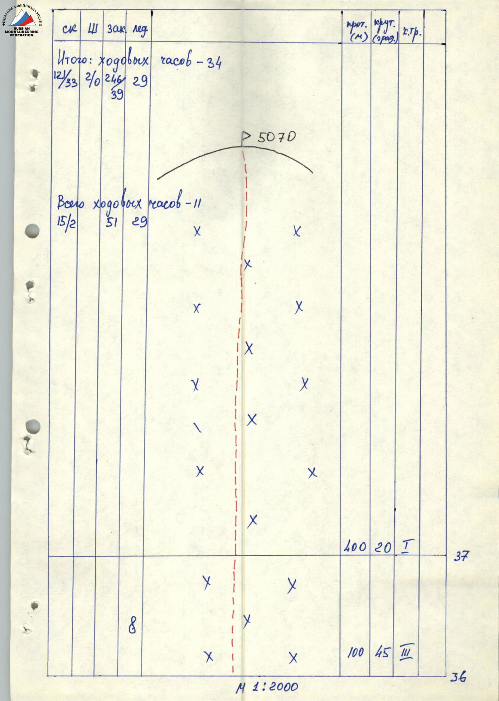
Height difference: 1270 m, length — 1930 m. Length of 6A category difficulty sections — 256 m. Average steepness of the main part of the route (p. Parandas) — 76.
-
Use of protection points:
| rock pitons | bolt hangers | chocks | ice screws |
|---|---|---|---|
| 121 | 2 | 246 | 29 |
| 33 | 0 | 39 | 0 |
-
Moving time 34 hours and 3 days.
-
Overnights: 1 — sitting on a rock ledge for 4 people. 2 — lying on p. Parandas.
-
Captain: Pechyonkin Mikhail Vladimirovich, Candidate Master of Sports. Participants: – Papin Vladimir Gennadievich, Candidate Master of Sports – Kogtev Evgeny Alekseevich, Candidate Master of Sports – Ivanov Vitaly Borisovich, Candidate Master of Sports.
-
Coach: Kurgin Sergey Nikolaevich, Master of Sports.
-
Departure to the route — July 6, 1990. On the summit — July 8, 1990. Return — July 3 is not correct and should be July 9 or another date after 8 July, 1990.
-
Novosibirsk Regional Committee for Physical Culture and Sports.
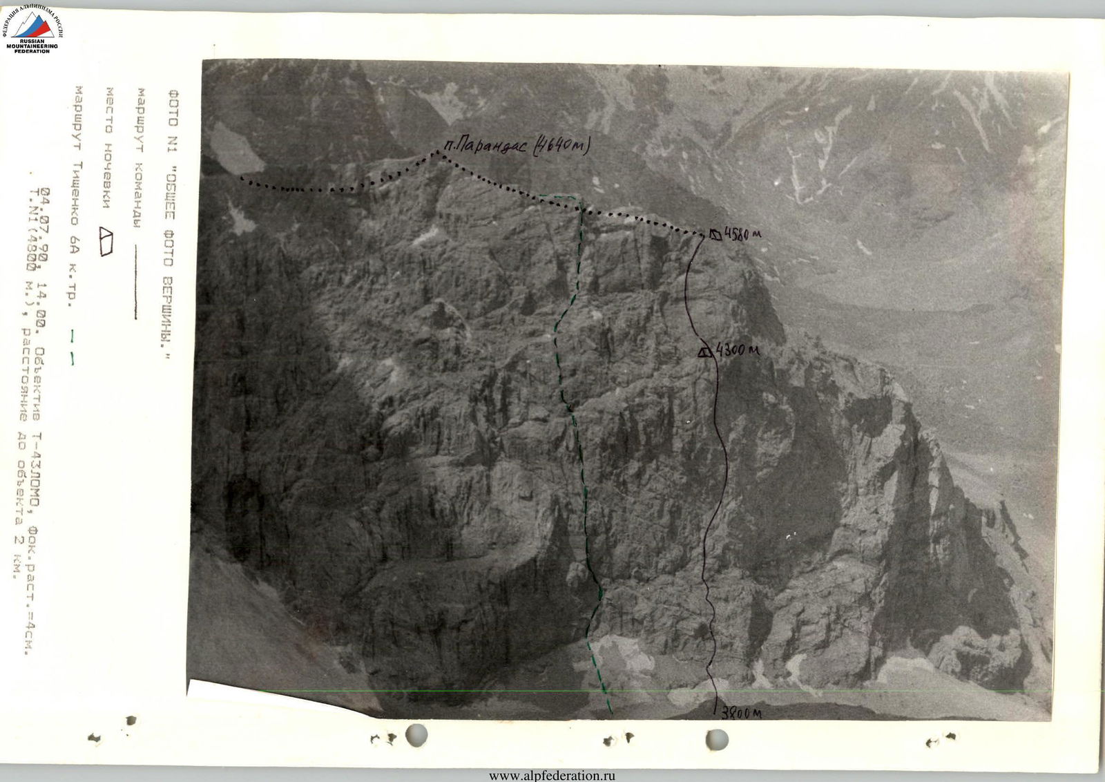
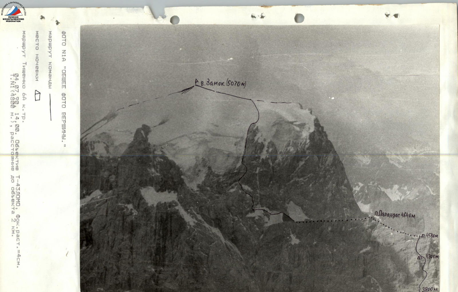 Photo No. 1A "General photo of the summit". Team route. Overnight location. Tishchenko's route 6B category difficulty. July 4, 1990, 14:00. T-43LOMO lens, focal length = 4 cm. Point No. 1 (4800 m), distance to the object 2 km.
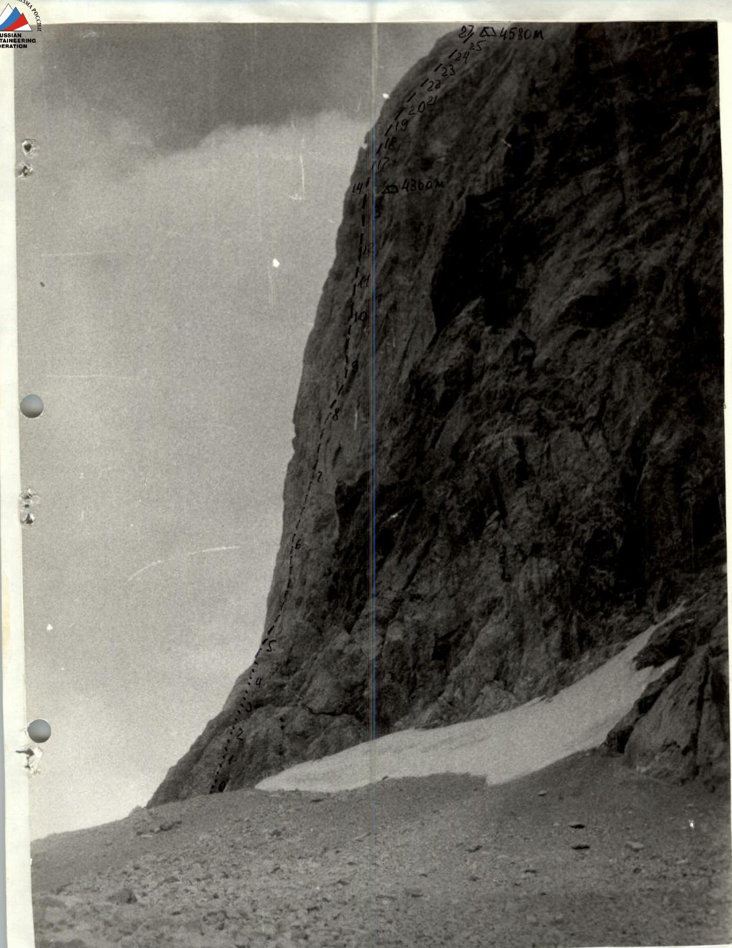 Photo No. 1 "General photo of the summit". Team route. Overnight location. Tishchenko's route 6B category difficulty. July 4, 1990, 14:00. T-43LOMO lens, focal length = 4 cm. Point No. 1 (4800 m), distance to the object 2 km.
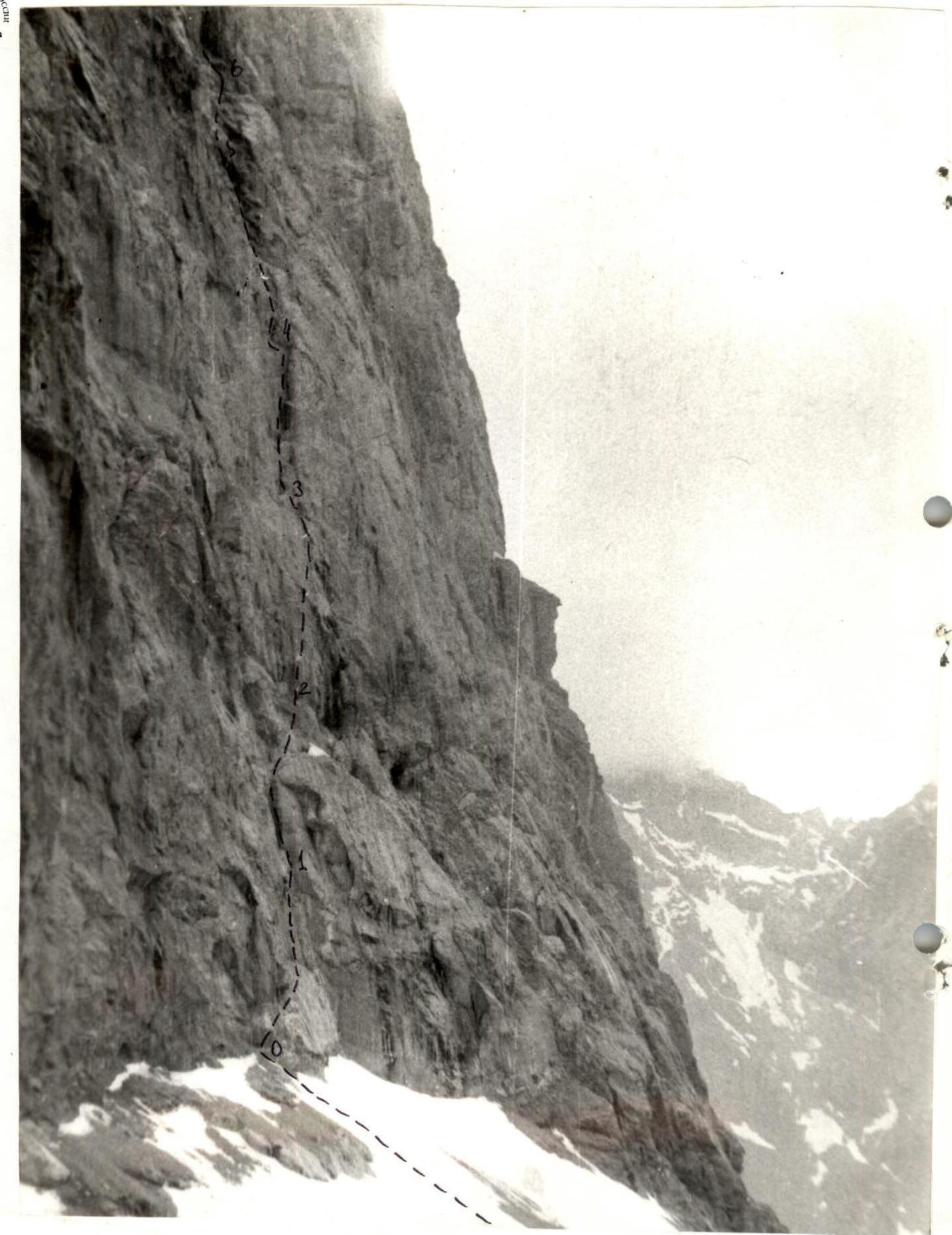 Photo No. 2 "Profile of the wall from the right". Team route. Overnight location. Route sections R0–R27. July 19, 1990, 16:00. T-43LOMO lens, focal length = 4 cm. Point No. 2 (3800 m), distance to the object 1 km.
Tactical Actions of the Team
Before the ascent, the team developed two tactical plan options. It was later decided to follow the second option, which completely replicated the tactical plan of the first ascenders.
On July 6, 1990, at 6:00, the team of four left the camp for the Bodkhona glacier and after 30 minutes, the Pechyonkin — Kogtev rope team began traversing the first rocky section. No particular difficulties were encountered on section R0–R7, but the climbing was tense. The first climber went with a Saratovkin shock absorber on a double rope.
By 12:00, the team approached the start of a large internal corner, where a change of rope teams was carried out according to plan. The Ivanov — Papin rope team went ahead, overcoming complex, smooth rocks using: – ITO, – friends, – chocks.
After the internal corner, the rope team passed through crevices 5–6 with eaves on sections R11–R12 on a very steep, smooth wall with few handholds. On section R13–R14, there is a control cairn in a "bank". One rope length above was the planned overnight location. The overnight was sitting on a comfortable ledge.
On July 7, 1990, at 8:00, the group started moving from the ledge straight up with a gradual traverse to the left, orienting towards a large internal corner filled with ice. Before entering the internal corner, a bolt hanger was hammered in for protection. The rocks were smooth with few handholds.
The weather deteriorated sharply. It started raining with sleet. Climbing became significantly more complicated, but the sufficient set of technical equipment allowed the team to reach the overnight location on the Parandas shoulder according to plan. The weather completely deteriorated, so the next day's departure was postponed until 8:00.
On July 8, we departed from the overnight location at 8:00. Strong wind. Sleet was falling at times. The Kogtev — Pechyonkin rope team continued the movement. On section R27–R28, we traversed three rope lengths of steep ice using ice screws as protection. Then we reached the icy rocks of the pre-summit bastion. Climbing became more relaxed, but sleet continued to fall, and the rocks were wet. Therefore, we reached the summit of the bastion by 18:00. Cloud cover lowered, and fog settled in. Sleet and gusty winds continued. So, we had to stay on the summit for about an hour to survey the descent route. Descent to the camp at Alaudin lakes by 23:30.
When traversing the route, increased attention was paid to safety. To achieve this, the following measures were taken: – early departure to the wall of p. Parandas and the pre-summit bastion, which excluded the possibility of the team being caught in a rockfall; – the first climber moved on a double rope with a Saratovkin shock absorber; – all running ropes were interconnected for backup; – movement on running ropes was with top-rope protection; – the available set of equipment allowed the group to descend from any section of the route; – the first aid kit and radio station were in different backpacks; – communication with the base camp and observers was maintained regularly (communication times: 10:00, 12:00, 16:00, 18:00, see radio communication log); – the movement of the group was monitored by observers located on the moraine below the route. The team removed all pitons used on the route. Food waste and trash were brought back to the base camp and disposed of there to protect the environment.
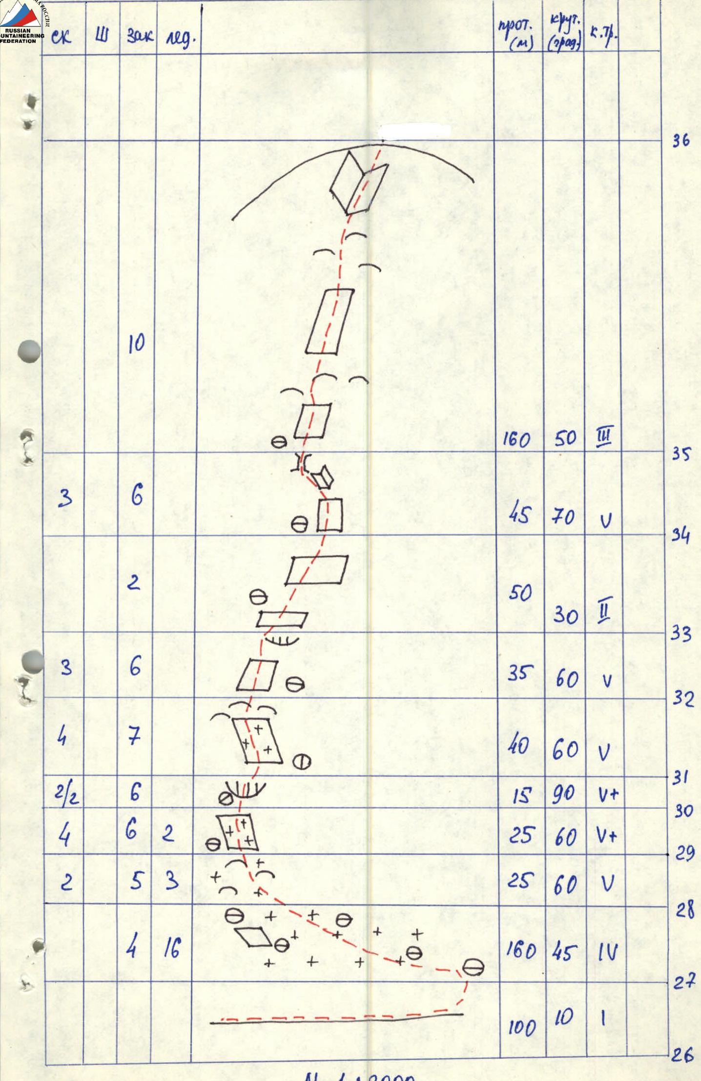
Route Description by Sections
The route begins under a clearly defined sheer internal corner starting 100 m above the beginning of the route. Movement is left and up through a black talus ledge to a crevice left of the sheer internal corner, section R0–R5. The route then goes: – up the crevice for 30 m, section R5–R6; – then right and up along an inclined ledge, section R6–R7, to a long, about 80 m, internal corner that ends in an eave; – approach to the corner along a 30 m wall, 6th category difficulty, section R7–R8.
Further movement: – along the internal corner with an eave, section R8–R10, the upper part of which and the eave are traversed using ITO, mainly on rock pitons; – section R10–R11 along the main crevice ("dollar") for 35 m to the next eave, section R11.
Exit to the eave on the left by free climbing 6B category difficulty and then over the eave to the right to a crevice where protection can be reliably organized using chocks. Further movement is along a steep crevice, section R14–R15, and exit to a "finger" over which an eave overhangs, R1 — control cairn. Overnight with tent setup is only possible at this location. (Further, a comfortable overnight can only be organized beyond the rope length before exiting to the ridge).
Section R15–R16 — 40 m along the crevice, approach under the eave. The crevice is partially filled with ice; ice screws can be used as protection points. The eave is traversed on the right part using ITO. After 40 m of movement along the crevice, section R17–R18, approach to the next key location, a hanging, destroyed belt, section R18–R19, which is traversed along an indistinct crevice to the right of a large, rusty, destroyed corner, alternating between free climbing and ITO. Section R19–R21 passes along crevices filled with ice. The next key location is an overhang with a black "stream", section R21–R22. It is traversed to the right of the large black "stream" first along a thin crevice to the right using ITO, then straight up to a small ledge. Section R22–R23: exit to a large ledge under a steep 45-meter chimney exiting to the ridge (section R23–R24).
Further along the ridge, 2B category difficulty, movement is towards the saddle between p. Parandas and p. Zamok, section R24–R26. Section R26–R28 — traverse of 160 m along a snow-ice slope to icy rocks. This section is recommended to be traversed in the morning from sunrise. Section R28–R33: movement left and up along the icy rocks of the Zamok bastion using ice and rock equipment.
Then: – movement along the left part of the rocky bastion to its summit, section R33–R36; – movement along a snow-ice slope, section R36–R37, to p. Zamok.
Descent from p. Zamok via route 1B category difficulty.