Ascent Log
(third ascent)
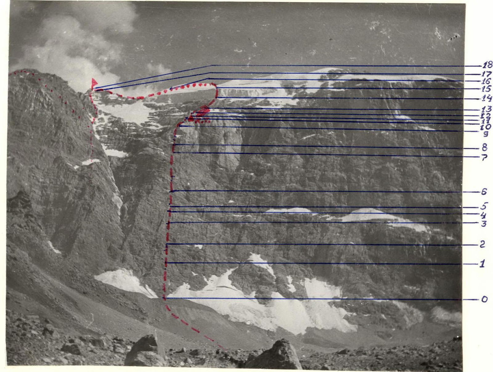
I. Ascent class — technical 2. Ascent area — Pamir, Fann Mountains 3. Maria peak via North counterfort of the 3rd ridge (4970 m) 4. Difficulty category — 5B 5. Route characteristics:
elevation gain — 1670 m, length of 5–6 km/tr. sections — 795 m, average steepness — 65°
- Pitons hammered:
| rock | ice | bolt | chocks | |
|---|---|---|---|---|
| for belay | 94 | 6 | 0 | 40 |
| for ITO | 0 | 21 | 0 | 0 |
- Total climbing hours — 33.5 hours
- Number of overnight stays — 2 in a tent, lying down.
- Team composition:
captain: Sazanov Viktor Vasil'evich members:
- Varov Viktor Ivanovich — CMS
- Beilin Yurii Iosifovich — CMS
- Martirosyan Al'bert Aleksandrovich — CMS
- Smirnov Yurii Viktorovich — CMS
- Team coach — Ivashev V.K. II. Date of departure on the route — August 5, 1980, date of return — August 7, 1980.
18
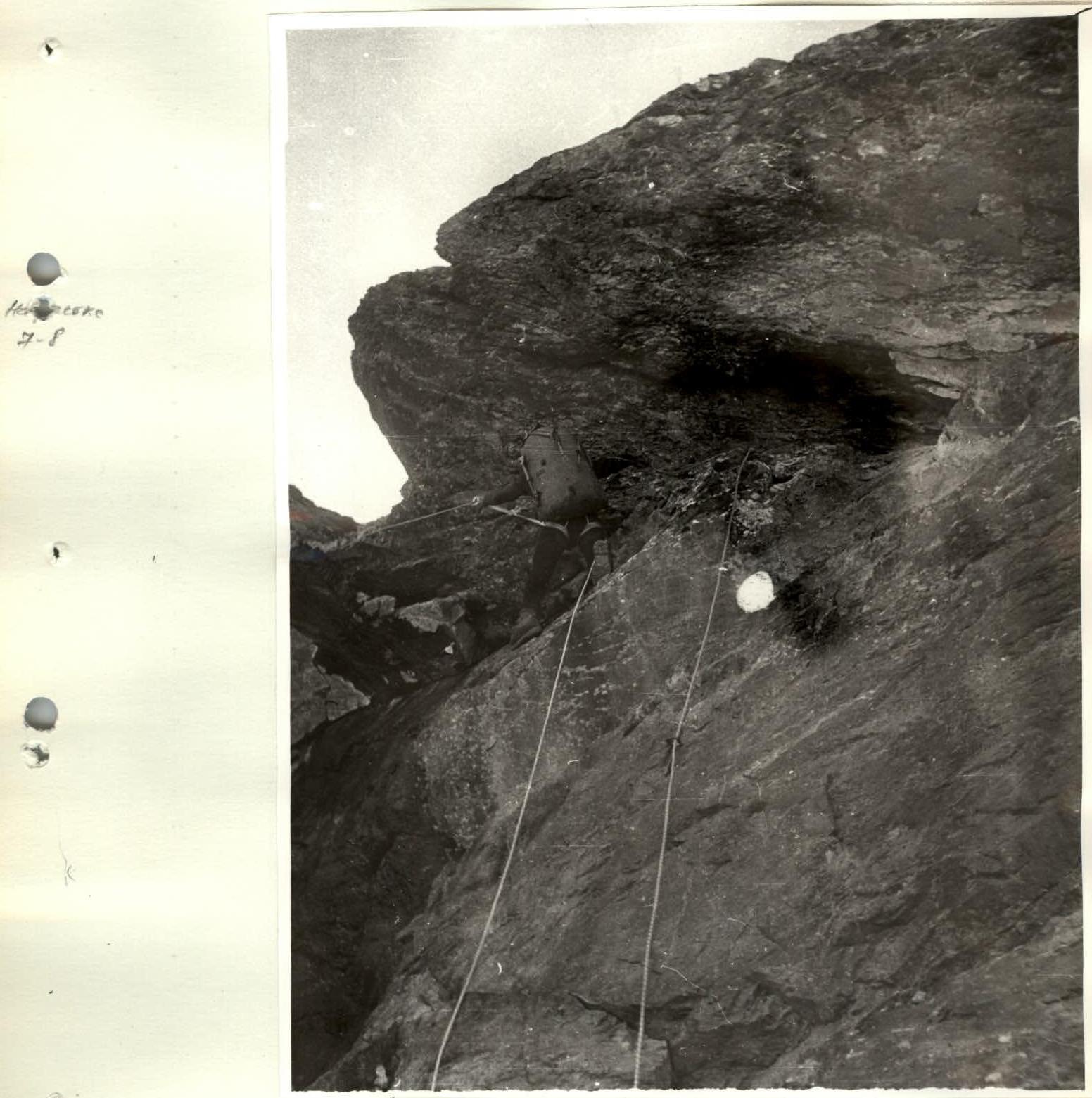
On the R7–R8 section
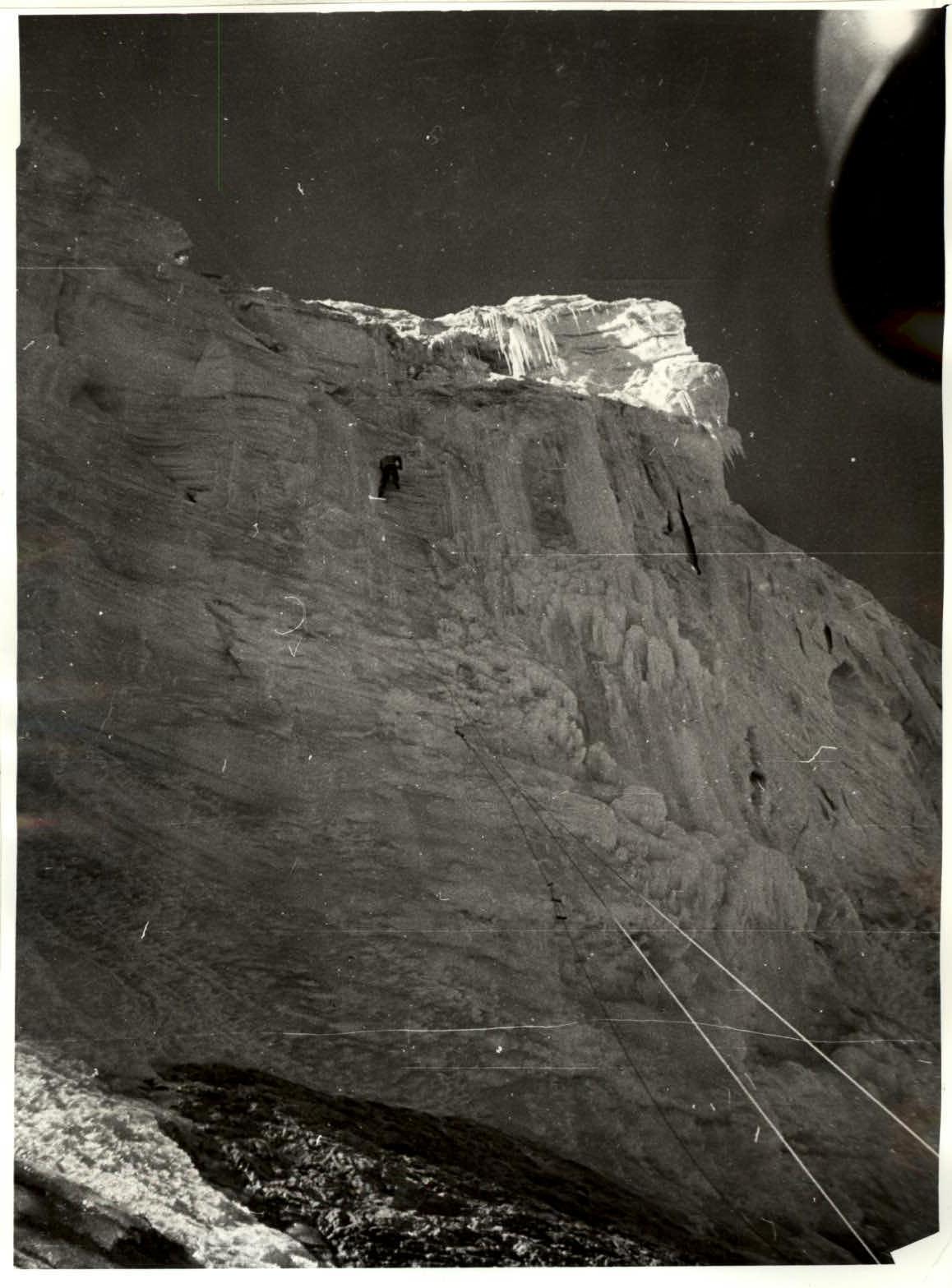
R16–R17 section
Passing the R17–R18 section
Brief description of the ascent. August 5, 1980 (day one)
- At 5:30, we leave the base camp on Lake Bibikhana.
- By 7:30, we're at the start of the route.
- At 8:00, the first rope team, Sazanov — Martirosyan, begins moving upwards.
The route starts at the lowest part of the rock "diamond". R0–R1 section: not difficult. We move simultaneously. Piton belay and protection through ledges.
R1–R2 section: the wall of the diamond transitions into a vaguely defined ridge. The rocks become steeper (in places, they overhang by 0.5–1 m). We ascend via the ridge to the top of the "diamond".
R2–R3 section: a steep wall with narrow ledges. We move as independent rope teams.
R3–R4 section: the upper part of the wall almost overhangs, but the rocks are solid, which is a relief.
- The first climber, Vitya Sazanov, climbs in galoshes and sets up a rappel on this section.
The wall leads to a ledge (R4–R5 section). Here, we gather as a group, plan our further route, and the rope teams switch. From the ledge, we move via a wall with overhanging sections (R5–R6 section) using rappel lines. The wall ends at a small ledge, from which the "nose" with the control cairn is visible. We then move directly upwards towards the light-brown rocks. The rocks are fragile, with many loose stones (R6–R7 section), and we must proceed with great caution, constantly monitoring the rope. We move as independent rope teams.
- After a slight easing of the terrain — a steep wall (R7–R8 section).
- Again, we use rappel lines.
- After the wall, we move along a vaguely defined ridge towards the "nose".
- A small detour along a ledge on the left.
- A platform, and the control cairn on the "nose" is five meters above.
The plan for the first day is accomplished. The weather is excellent. In the last rays of the sun, we set up the tent.
August 6, 1980 (day two)
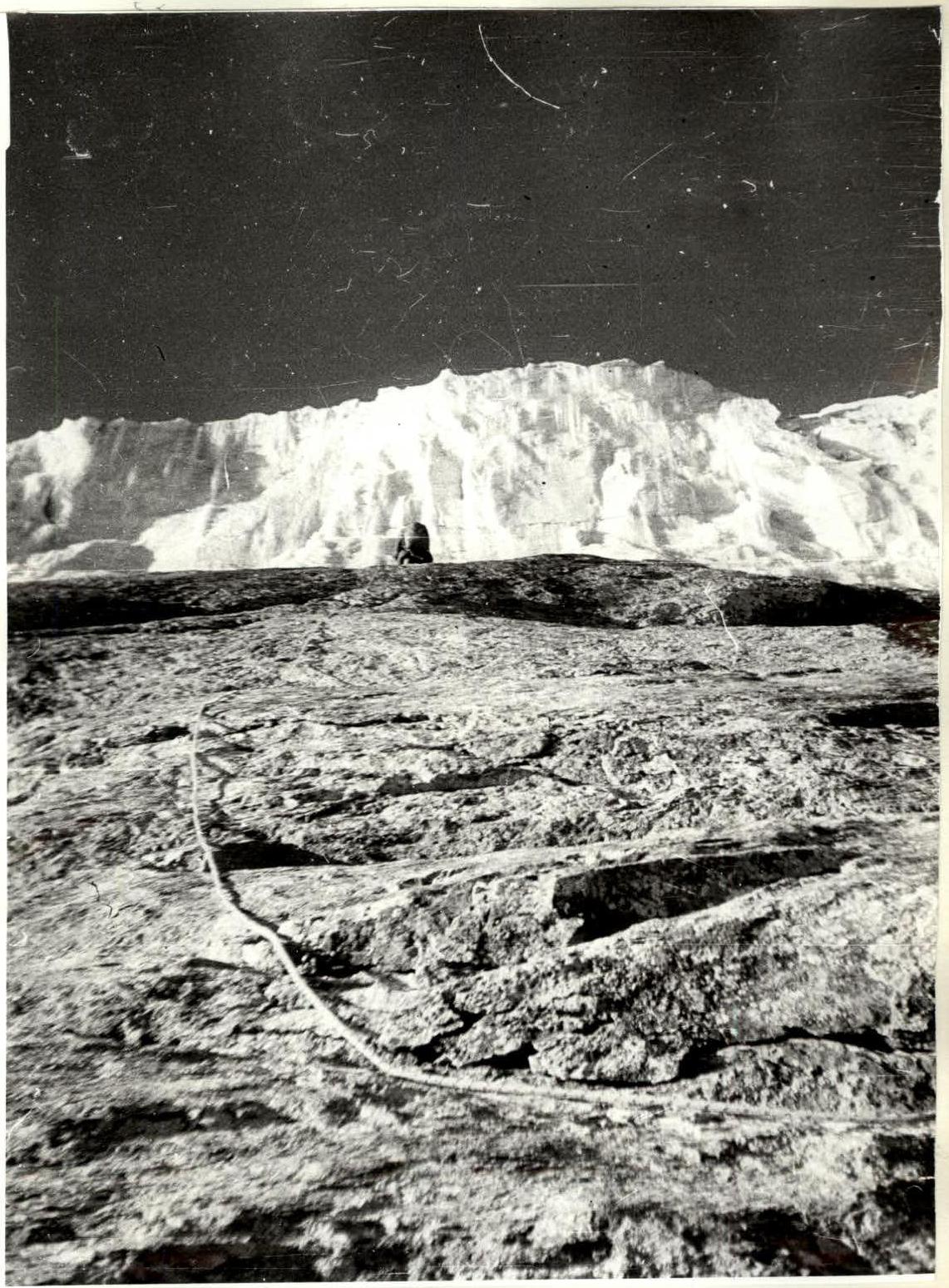
At 8:00, we leave the bivouac near the control cairn, heading towards the line of shade on the ice wall. And as preparation for the ice wall, the first section of this day (R11–R12 section) — slabs covered with ice. We move as autonomous rope teams with alternating belay. Further, along a snow-ice slope (R12–R13 section) to the last rocks of the day. The rocks are not difficult, but covered with ice. For speed, we set up 2 rappel lines. At the end of the rocks, under the ice wall, we find a somewhat protected spot in case of a moderate rockfall. We have a snack with hot tea, and Sazanov and Martirosyan proceed to process and ascend the ice wall. The others reorganize their backpacks and observe the wall (it's constantly cracking) and the rope team. Vitya works with knee pitons (a new suggestion by Yura Gorenchuk). It's convenient. This section of the route (R14–R15 section) is interesting and challenging but objectively hazardous. The timing of ice block falls is arbitrary, creating additional psychological pressure. The wall leads to a snow-ice slope on Maria's western ridge. We ascend it to the left and upwards onto a scree ridge. While passing the ice wall, everyone gets wet, and on the ridge, there's a strong and cold wind. Therefore, we decide to ascend to the summit the next day and for now, dry off and warm up. We set up the tent on the ridge at the start of the descent.
August 7, 1980 (day three)
At 6:00, we depart lightly loaded towards the summit. The path goes directly along the ridge. There are few technical difficulties on it. After 2 hours and 30 minutes, we return to the tent, have breakfast, and begin descending via the 4B category route. At 19:00, we're back at the base camp on the lake.
Table of main characteristics of the ascent route to Maria peak via the North counterfort of the 3rd ridge, 5B category.
- Peak: Maria
- Direction: North counterfort
- Ridge: 3
- Difficulty category: 5B
| Date | Section | Steepness | Length, m | Terrain character | Difficulty | Condition | Weather | Rock pitons | Ice pitons | Bolt pitons | ITO | Chocks |
|---|---|---|---|---|---|---|---|---|---|---|---|---|
| 05.08.1980 | R0–R1 | 50° | 120 | wall | 4 | broken rocks | good | 6 | 3 | |||
| R1–R2 | 70° | 80 | ridge | 5 | -" - | 7 | 2 | |||||
| R2–R3 | 75° | 100 | wall | 5 | -" - | 11 | 6 | |||||
| R3–R4 | 80° | 45 | wall | 6 | monolith | -" - | 10 | 2 | ||||
| R4–R5 | 60° | 35 | ledge | 4 | -" - | 2 | 1 | |||||
| R5–R6 | 75° | 85 | wall | 6 | -" - | 9 | 4 | |||||
| R6–R7 | 70° | 170 | wall | 5 | broken rocks | -" - | 14 | 9 | ||||
| R7–R8 | 80° | 40 | wall | 6 | monolith | -" - | 3 | 6 | ||||
| R8–R9 | 65° | 140 | ridge | 5 | monolith | -" - | 12 | 1 | ||||
| R9–R10 | 70° | 60 | ridge | 4 | -" - | 2 | 5 | |||||
| R10–R11 | 30° | 40 | ledge | 3 | -" - | 2 | 1 | |||||
| \multicolumn{13}{l}{Departure time — 8:00. Stop for bivouac — 20:00.} | ||||||||||||
| \multicolumn{13}{l}{Climbing hours — 12. Overnight stay in a tent on a platform, lying down.} | ||||||||||||
| 06.08.1980 | R11–R12 | 50° | 80 | slabs | 3 | icy rocks | -" - | 3 | 0 | 1 | ||
| R12–R13 | 40° | 80 | slope | 3 | snow | -" - | 2 | 1 | ||||
| R13–R14 | 65° | 100 | wall | 4 | monolith with ice | -" - | 4 | |||||
| R14–R15 | 85° | 70 | ice wall | 6 | flowstone | -" - | 24 | 21 | 3 | |||
| R15–R16 | 30° | 400 | slope | 3 | snow-ice | -" - | 3 | |||||
| \multicolumn{13}{l}{Departure time — 8:00. Stop for bivouac — 19:30.} | ||||||||||||
| \multicolumn{13}{l}{Climbing hours — 11.5. Overnight stay on the ridge in a tent, lying down.} | ||||||||||||
| 07.08.1980 | R16–R17 | 25° | 400 | ridge | 2 | broken | -" - | 2 | ||||
| R17–R18 | 50° | 200 | ridge | 4 | -" - | 4 | 2 | |||||
| \multicolumn{13}{l}{Climbing hours — 2.5.} | ||||||||||||
| \multicolumn{13}{l}{Descent via the 4B category route.} | ||||||||||||
| \multicolumn{13}{l}{Departure time 6:00. Return to base camp — 19:00.} | ||||||||||||
| \multicolumn{13}{l}{Climbing hours — 10.} |