ASCENT DESCRIPTION TO THE MARIA PEAK VIA THE NORTHERN RIDGE
Approximate 5A category difficulty
Class of technically challenging ascents
The route was traversed by the LOS SDSO "Burevestnik" team
1. Group Composition
The ascent was made by the LOS SDSO "Burevestnik" group in the following composition:
- SMRCHIK V.L. — leader, 1st sports category
- TIKHVINSKII S.B. — participant, CMS
- LIPCHINSKII A.G. — participant, 1st sports category
- TROSHCHENENKO A.L. — participant, 2nd sports category
- KAIDANOVSKII M.N. — participant, 2nd sports category
The group's composition was formed during the ascent preparation in Leningrad and remained unchanged.
The participants' qualifications were checked and confirmed by the releasing officer — MS VYLEGZHANIN G.M.
The participants were examined and cleared for the ascent by the doctor — CMS TIKHVINSKII S.B.
III. Ascent Description
Day One
The group left the base camp near Lake Dyshakha at 2:00 and reached the base of the second couloir in 2 hours, counting from the Timer Tau pass towards the Kulikalon Wall. The couloir (sect. R0–R1):
- initially wide and gentle, it steeply rises and narrows;
- the couloir's bed consists of heavily smoothed granite rocks;
- slopes are made of heavily fragmented rock with a tile-like structure;
- many debris and loose rocks;
- we move close to each other;
- climbing is not complicated but unpleasant.
The couloir abuts a wall and divides into two branches:
- the right one is inconvenient for movement and leads away;
- the left one turns into a groove and leads to the "osmiaya polka" (eighth shelf) under the wall (sect. R1–R2).
The wall consists of fragile rocks and is traversed as follows:
- The first participant ascends without a backpack and sets up the rope.
- The second participant ascends with a third rope, and the first rope team sets up another rope on the slab (sect. R2–R3).
- Further, we move simultaneously across the scree and snowy patches to a crescent-shaped snowfield (sect. R3–R4), which leads left-up-right to a saddle between the first and second gendarmes.
We spend the night on a narrow, scree-covered ridge. While the second rope team prepares the site and hot food, the first team sets up ropes (photo 2) on the rocky ascent of the second gendarme (sect. R4–R5).
Characteristics of the overnight site:
- the ridge saddle is narrow, barely enough for the tent;
- a safety rope is stretched across the tent, and participants are attached to it with a sliding carabiner;
- the night is warm, and the site is soft;
- the overnight stay is comfortable.
Day Two
After passing the ropes, we move left-up (sect. R5–R6), leaving the towers of the second gendarme to the right. After 10–12 rope lengths, we reach inclined slabs at the end of the gendarme and traverse (photo 4) the steep southern slope of the second gendarme (sect. R6–R7) along a poorly defined ledge to a saddle before the ascent of the northern ridge. From the saddle, we again move left-up across scree ledges, small rocky outcrops, and snowy patches (sect. R7–R8) to a scree-covered site before the fourth couloir, which separates the northern ridge as it turns right here from the northwest wall of the Parrya massif. We take a break on the site (photo 3), and while three team members prepare hot tea and food, a pair sets up 30 m of ropes on smooth, polished rocky brows rising directly from the site to the ridge (sect. R8–R9). Climbing is challenging; there are few cracks, and many loose rocks.
After a one-hour rest, we ascend directly up the polished rocks to a broad snow-rock ridge. A light fog envelops us on the rocks on the ridge, turning into continuous cloud cover and wet snow. After traversing 5–6 rope lengths along the ridge, we set up a bivouac in a convenient depression (photo 5), protected from the wind by a rocky outcrop. We quickly trample down the site, set up the tent, cook, and dry our gear. We exit several times to survey the further route. In the gaps, a snowy ascent to the Uzlovaya peak is visible, but the route is very difficult to survey.
Day Three
We depart at 7:00, waiting for dawn and surveying the route. We move towards the base of the snow-ice ascent (photo 6), to which a straightforward snow ridge with rocky outcrops leads (sect. R10–R11), ending in a clearly defined saddle with overhanging cornices.
Further:
- up the steep snow to the ice belt (sect. R12–R13), through which the first participant cuts steps, installs two ice screws, and sets up ropes.
- another rope length of steep snow, and the ridge begins to flatten, turning into a snowfield (sect. R13–R14) before the Uzlovaya peak.
At 12:00, we are the first ascenders to reach the Uzlovaya Maria peak (photo 7); 40 minutes are spent setting up a cairn and leaving a cache for a future traverse of the Kulikalon Wall.
We move left towards the Main peak along a broad, gentle ridge (sect. R14–R15) and encounter a wall (sect. R15–R16) forming an almost rectangular step in the ridge, which cannot be bypassed either to the right or left. Along a steep, inclined ledge, there is complex climbing (10 m), followed by very challenging climbing directly up using artificial holds (AID). The exit from the wall to the ridge is difficult; the rock transitions into a pile of small, fragmented rocks. Further along the fragile snow-rock ridge (sect. R16–R17) to the summit tower and then across rocks of moderate difficulty (sect. R17–R18) to the summit.
14:00. We are on the summit (photo 8) — Main Maria; no signs of previous ascents are found. We build a cairn, congratulate each other on the first ascent, and begin our descent along the ascent route to the second overnight site at 14:30, where our bivouac is left.
The R16–R15 section, on the return, is traversed by rappelling (one rope) and leaving a loop. The ice is traversed with piton protection during the descent, and we reach the overnight site by 17:30.
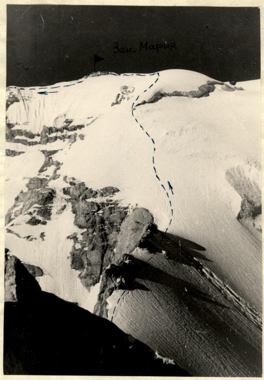
Photo 6.
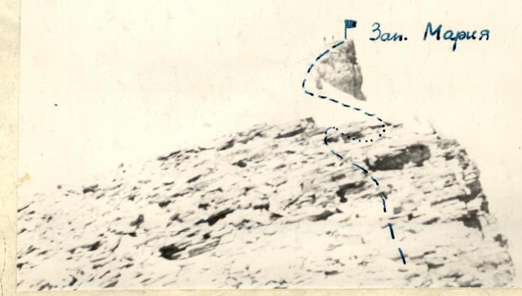
Photo 7.
Day Four
We rise at 6:00, pack up the bivouac, have breakfast, and depart at 7:15. We descend along the ascent route to the saddle between the first and second gendarmes. During the descent, we survey an alternative descent route to the left along an inclined ledge from the saddle between the ridge and the second gendarme. The possible descent path is intersected by:
- rockfall tracks,
- one avalanche groove.
Therefore, it can be recommended only to a group of four with good technical preparation (1st sports category).
Our descent follows the ascent route. Five rappels and three rope lengths with alternate protection are set up. We return to the base camp by 16:00.
A detailed technical characterization of the route is presented in the table and the route steepness graph.
ROUTE STEEPNESS GRAPH BY SECTIONS
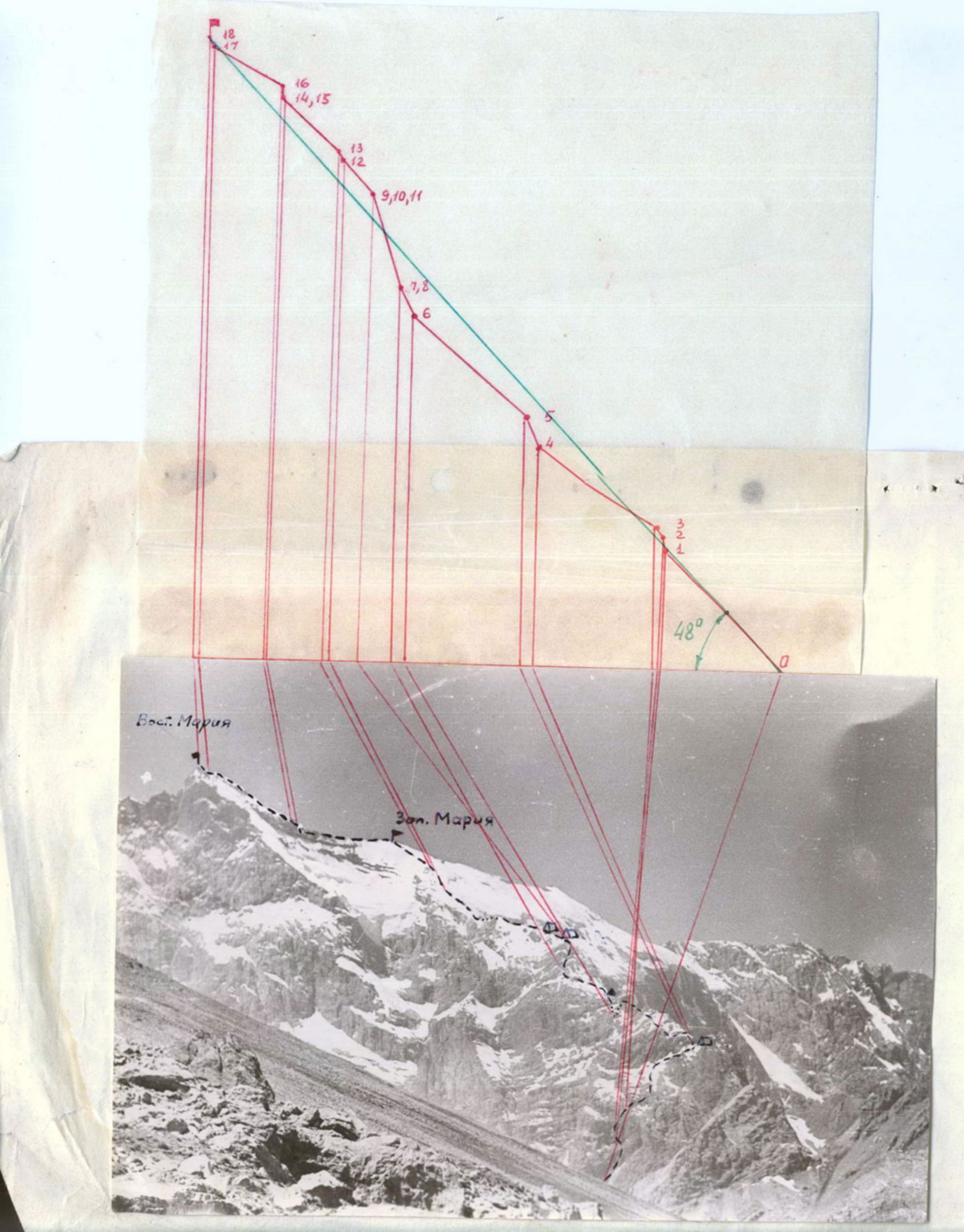
TABLE OF MAIN ROUTE CHARACTERISTICS BY SECTIONS
ASCENT ROUTE TO MARIA PEAK VIA THE NORTHERN RIDGE 5000 m (FAN MOUNTAINS)
ELEVATION GAIN 2000 m
AVERAGE STEEPNESS OF THE ROUTE — 48°
| Traversed Sections | Average Steepness, ° | Section Length, m | Terrain Characteristics | Technical Difficulty | Method of Traversing and Protection Conditions | Weather | Departure Time, h:min | Rocky Obstacles | Ice Obstacles | Overnight Conditions |
|---|---|---|---|---|---|---|---|---|---|---|
| Day One | ||||||||||
| R0–R1 | 45 | 450 | rocks in couloir | not complicated | simultaneously, close together | clear | 13:00 | — | — | warm overnight on scree ridge |
| R1–R2 | 80 | 30 | not very solid rocks | very complicated | ropes, piton protection | clear | — | 5 | 3 | — |
| R2–R3 | 55 | 30 | rocky slab | complicated | ropes, piton protection | clear | — | — | — | — |
| R3–R4 | 30 | 360 | snow, scree | easy | simultaneously, ice axe protection | clear | 18:30 | 8 | — | — |
| Total for the day | 5 h 30 min | |||||||||
| Day Two | ||||||||||
| R4–R5 | 65 | 80 | rocks, granite | difficult | ropes, piton protection | clear | 6:30 | 6 | — | warm overnight in snow ridge depression |
| R5–R6 | 40 | 400 | rocks, snow | moderate difficulty | alternately, intermediate protection | clear | — | 8 | — | — |
| R6–R7 | 60 | 80 | rocks | difficult | ropes, piton protection | light fog | — | 6 | — | — |
| R7–R8 | 40 | 500 | rocks, snow | moderate difficulty | alternately, piton protection | light fog | — | 4 | — | — |
| R8–R9 | 70 | 250 | polished granite | difficult | ropes, piton protection | heavy fog | — | 12 | — | — |
| R9–R10 | 20 | 200 | snow, rocks | easy | simultaneously, via outcrops | snow, rain | 16:00 | — | — | — |
| Total for the day | 11 h 30 min | |||||||||
| Day Three | ||||||||||
| R10–R11 | 10 | 250 | snow, rocks | easy | simultaneously, via outcrops | clear | 7:00 | — | — | overnight at the same location |
| R11–R12 | 45 | 120 | snow | moderate difficulty | alternately, ice axe | clear | — | — | 2 | — |
| R12–R13 | 50 | 20 | ice | difficult | ropes, steps, ice screws | clear | — | — | — | — |
| R13–R14 | 40 | 200 | snow | easy | alternately, ice axe | clear | — | — | — | — |
| R14–R15 | 10 | 600 | rocks | easy | simultaneously, via outcrops | clear | — | 6 | — | — |
| R15–R16 | 85 | 30 | fragile rocks | very complicated | ropes, AID | clear | — | — | — | — |
| R16–R17 | 26 | 200 | fragmented rocks, snow | easy | simultaneously, via outcrops | clear | — | — | — | — |
| R17–R18 | 60 | 30 | rocks | moderate difficulty | alternately, via outcrops | clear | 16:00 | 9 | — | — |
| Descent from the summit and overnight along the ascent route | 17:30 | — | 2 | — | ||||||
| Total for the day | 12 h 30 min | |||||||||
| Descent to base camp along the ascent route | clear | 7:30 to 15:00 | 14 | — | — | |||||
| Total for the ascent | 37 h 00 min |