Ascent Log
-
Ascent category — technical
-
Ascent region — Fan Mountains
-
Ascent route — v. Zindon via the north wall, 4800 m
-
Ascent characteristics: height difference 1000 m average steepness 75°, complex section length 880 m
-
Pitons used: rock 207, including 24 wooden wedges ice 8, no bolt pitons
-
Total climbing hours 95.5
-
Number of nights and their characteristics — seven: sitting in a tent — 5, good tent — 2
-
Team of the Central Sports Club "TRUD"
-
Surname, name, patronymic of the team leader, participants and their qualifications:
- Emelyanenkov Yuri Sergeyevich — Candidate for Master of Sports, team leader
- Kostin Boris Ilyich — Candidate for Master of Sports
- Krainov Nikolai Petrovich — Master of Sports
- Pavlichenko Lev Nikolayevich — Master of Sports
- Tyslyatsky Albert Ivanovich — Candidate for Master of Sports
-
Team coach Krainov Nikolai Petrovich
-
Departure to the route — August 12, 1974 return — August 20, 1974
3 people 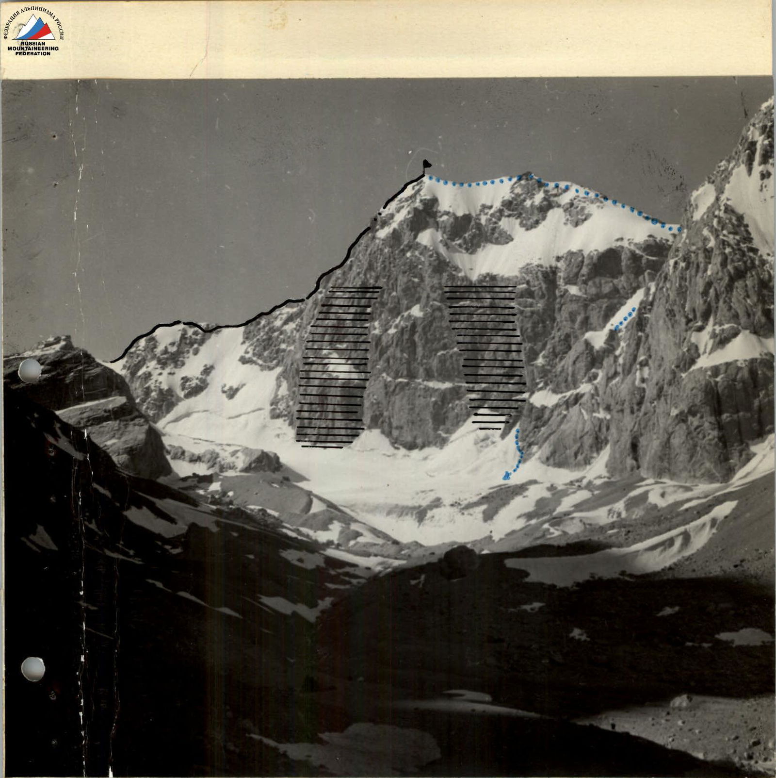
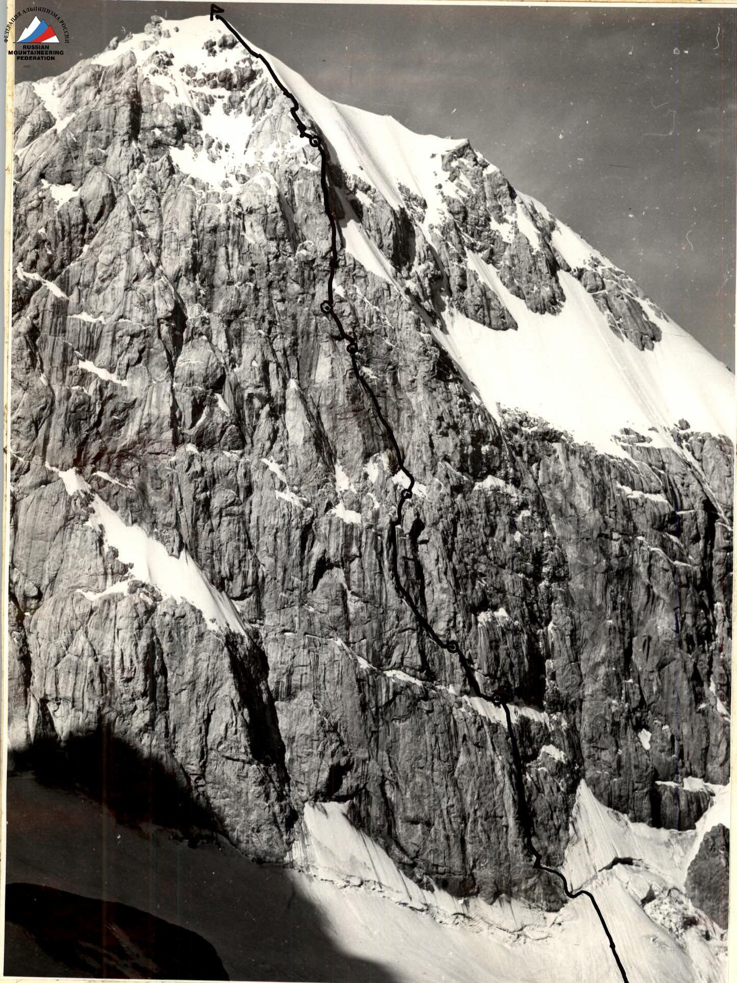
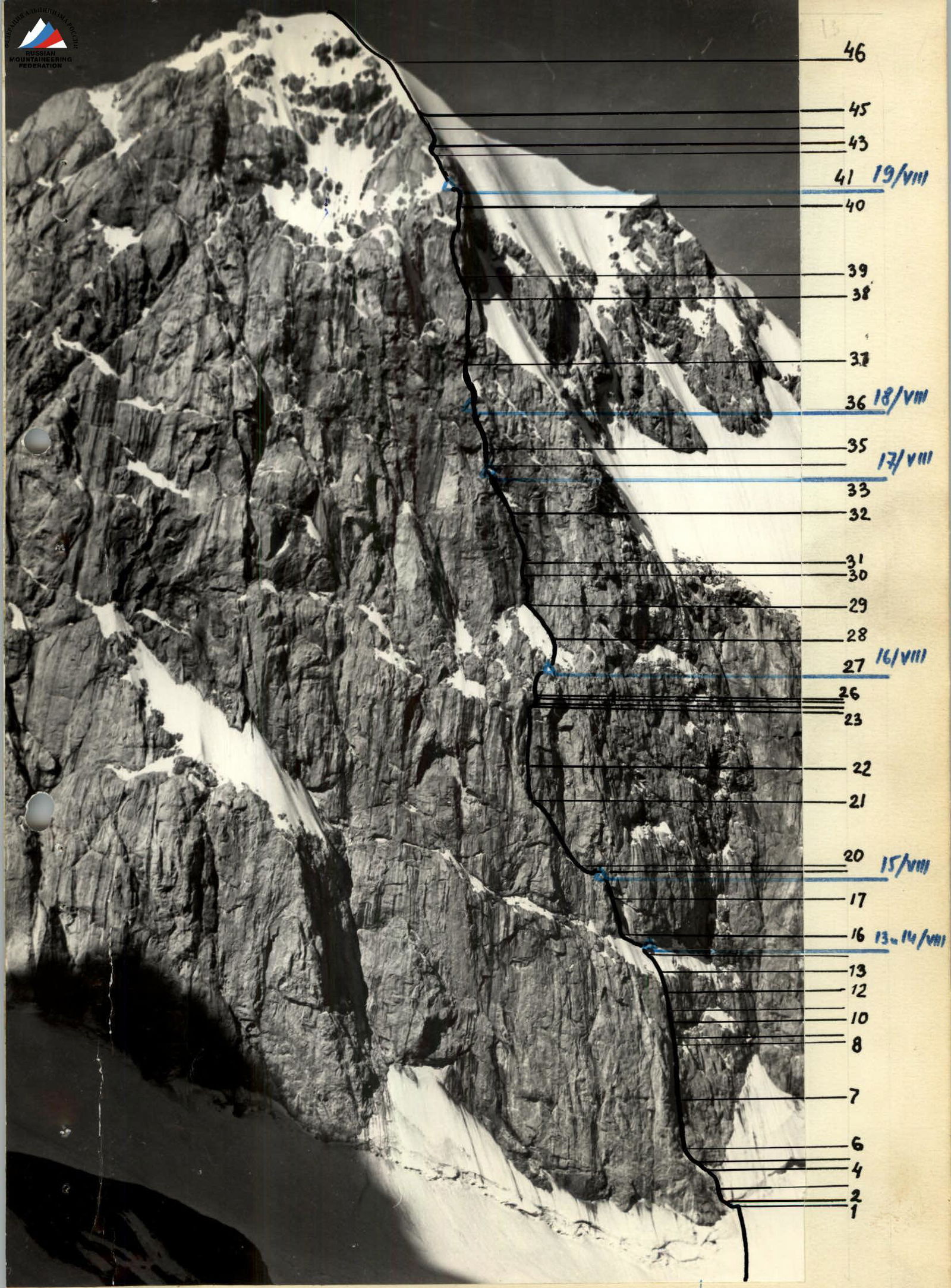
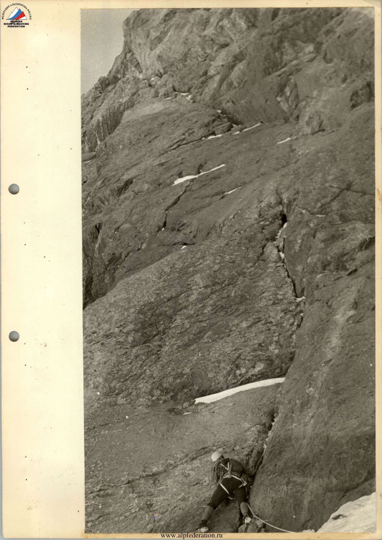
Photo 1
Rockfall Hazardous Zones on the North Wall
Route to v. Zindon via the west ridge — 4A category of difficulty
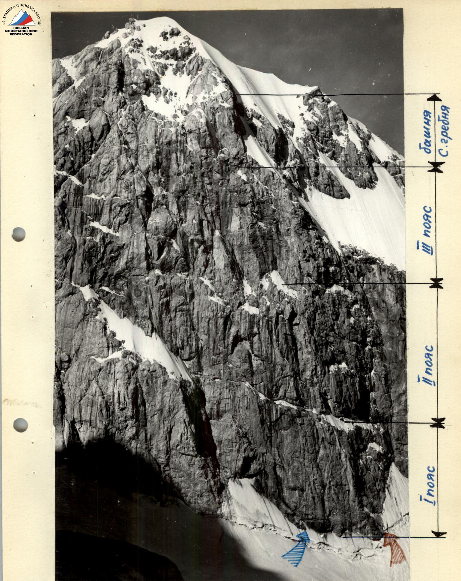
Photo 2. Start of the route planned by the Ukrainian "Burevestnik" team
 www.alpfederation.ru↗
 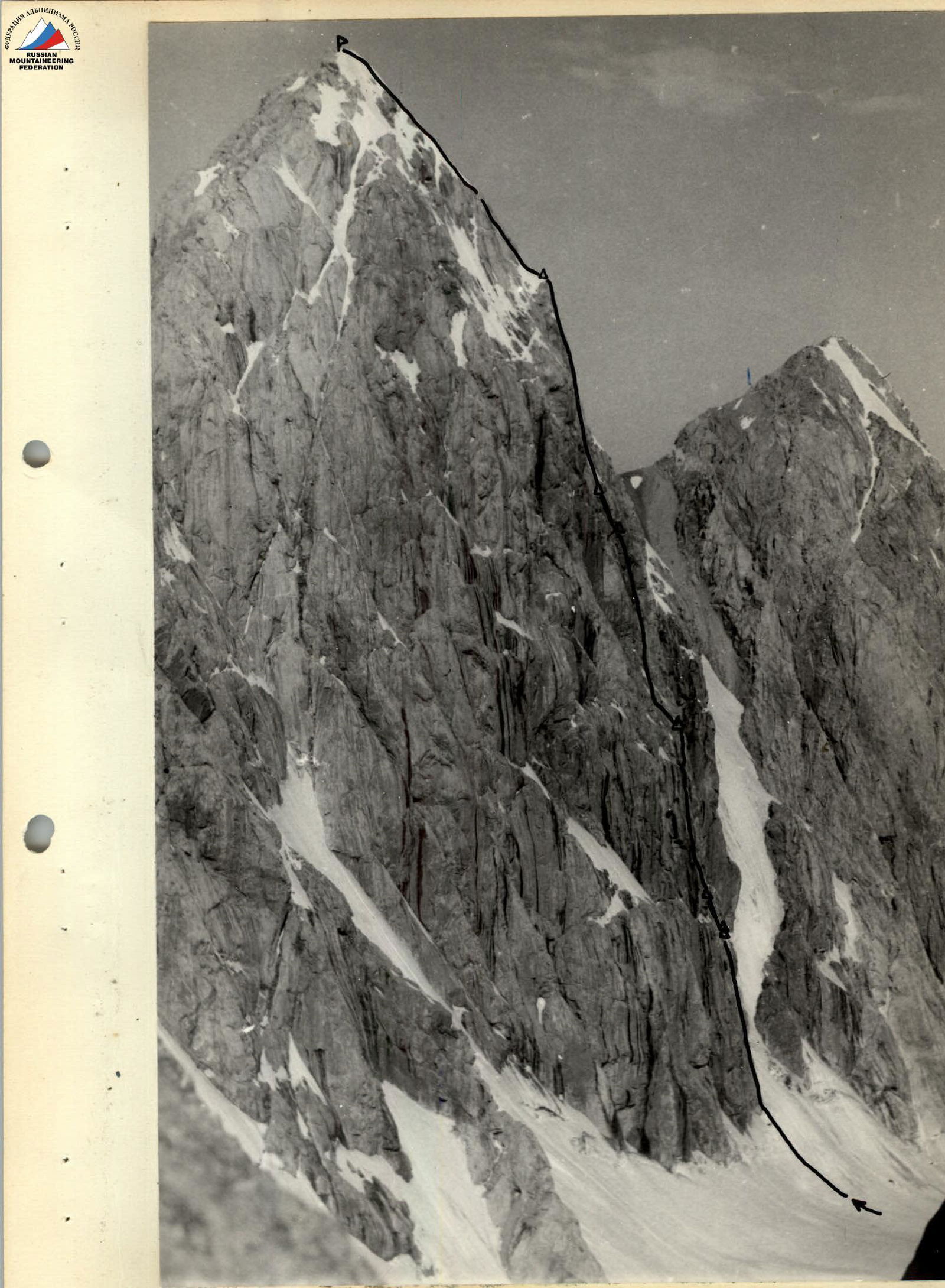 www.alpfederation.ru↗
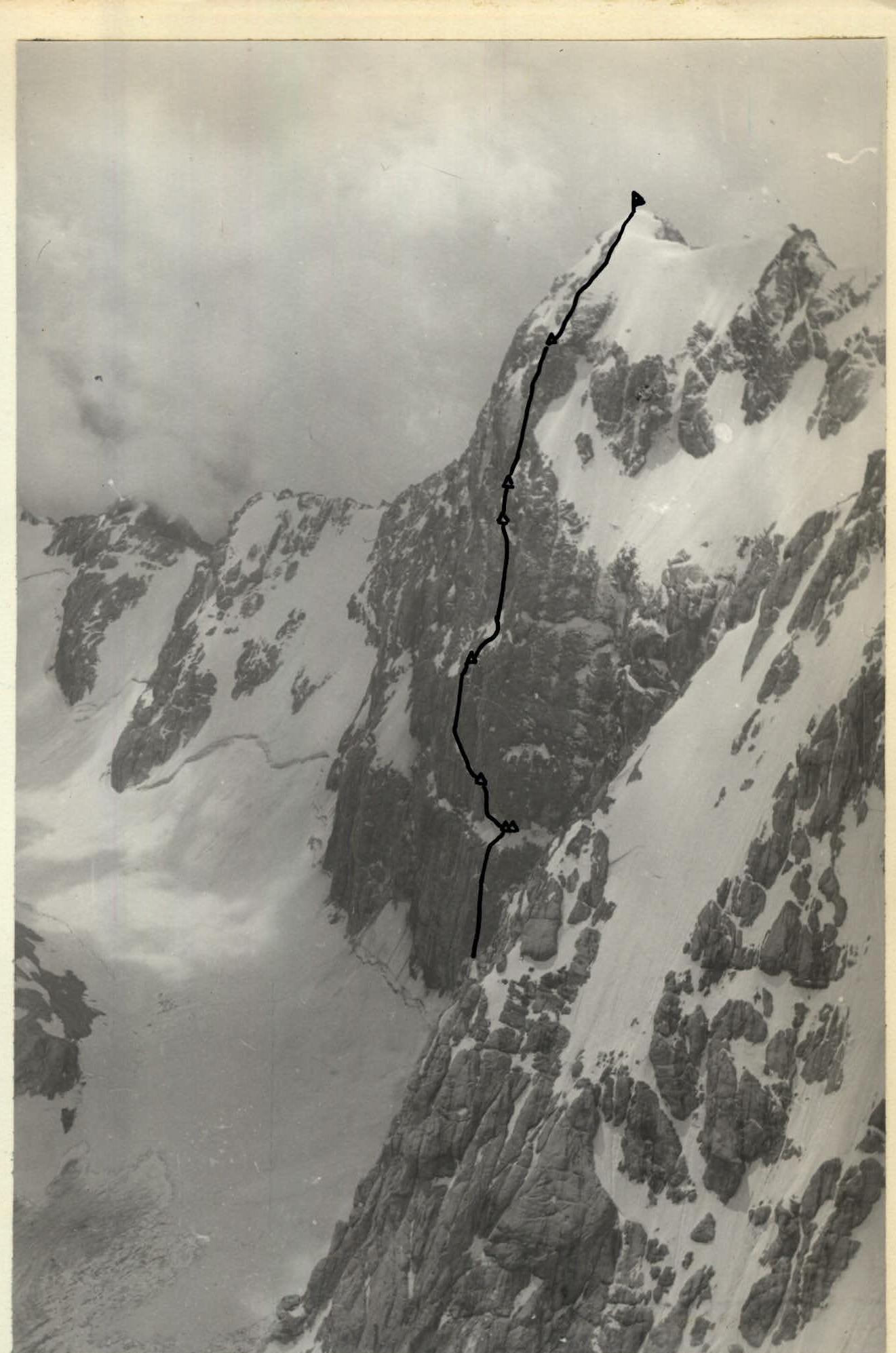
Photo 5. Zindon summit from the Chaplygin peak.
August 1
By 14:00, the team and the observation group were at the moraine under the wall of v. Zindon. After a recent cyclone, the wall, silvered by fresh snow, looks particularly harsh and inaccessible. It's no coincidence that this gorge and mountain bear the gloomy name "Zindon," which translates to "prison" in Russian. But we're not here to dwell on somber toponymy. We carefully examine and refine the planned route, make detailed sketches — they will help us keep a detailed ascent log, and select equipment for tomorrow.
Despite the sunny day, it's cold here. We can't help but recall how much warmer it was here three weeks ago.
August 12
The path to the start of the route along the glacier takes only 15 minutes from the tents. At 7:00, the rope team begins ascending the 100-meter snow slope and soon approaches the bergschrund.
The bergschrund is filled with snow. Traversing it left under the overhanging 3-meter ice wall, we reach the rocks. The rocks are generously covered with ice, but the ice layer is too thin to use pitons. We manage to carve out narrow steps, but it's a far cry from being able to hang ladders on these "slippery" seven meters, both literally and figuratively. The next 10 meters of unpleasant climbing on "slick" rocks and a snow ledge bring the rope team to the left edge of the 130-meter steel-colored mirror of the first belt. This "steel mirror" is a real problem on the route!
Five meters of wet rocks lead to a 35-meter vertical internal corner. After 15 meters, the corner is interrupted by a 8-meter overhanging wall. A wide crack, filled with ice and snow, goes straight up. Handholds are practically nonexistent. To make progress, we have to use wedging with hands and feet in the crack. We use:
- channel pitons,
- wooden wedges,
- ladders,
- a platform.
But first, we have to clear the crack of snow and carve out ice. Some pitons and wedges are hammered in two or three times before we start to believe in their reliability. The wall yields inch by inch. At 15:00, the next rope team arrives from below and relieves their teammates.
The internal corner leads to a tiny, steep ice-covered ledge. Even after chopping ice, it's hard for one person to stand on the ledge. We have to hang a platform to organize further belays. After the ledge, the internal corner continues straight up, with handholds still scarce, but without the crack, although some cracks appear. Piton — ladder, piton — ladder... and so on for 30 meters, until the team is under an overhang.
The overhanging smooth rock is climbed on the left side. The overhang ends with a 1.5-meter rock outcrop, so "alive" that it seems to be held together by sheer willpower, so unreliable that, as we move past it, barely touching it, we can't help but try not to breathe on it. As soon as we pass this section, we immediately set up and secure the rappel rope directly through the overhang to get away from this rock "mine." That's all for today!
We descend, leaving the rappel rope in place. Today, we covered over 200 meters, including 80 meters of exceptionally difficult rock climbing. At 19:00, everyone gathers at the tents. In the evening, we have a final briefing before heading back to the wall. We review today's progress.
The wall is very steep and complex, requiring a significant expenditure of physical strength. Tomorrow, the team faces a challenging task:
- We need to reach the ice ledge under the rocks of the second belt, where we presumably can set up a campsite.
We depart in the following footwear:
- three participants in crampons,
- two participants in Vibram boots; we take three pairs of galoshes with us.
August 13
7:00. The rope team departs. Three team members at the bivouac pack the remaining gear and supplies. By 10:00, only the observers are left at the tent.
The rappel ropes are now at an end. We then climb 10 meters along smooth slabs with ice and a thin layer of loose snow. Next, we overcome a 3-meter negative wall and enter a monolithic, almost vertical slab. There are no cracks or handholds! Only a few meters above our heads is a diagonal crack, steeply rising to the right. The crack is filled with snow. If only we could reach it! We have to make a decision.
With great difficulty, the tips of our fingers manage to grasp the scarce micro-relief of the slab. Here, friction helps with our hands, but what about our feet? We find a foothold for one, two, or three fingers,
 www.alpfederation.ru↗
and we're already happy. We make progress, another half meter.
www.alpfederation.ru↗
and we're already happy. We make progress, another half meter.
There it is, the crack! We brush off the snow, hammer in a piton. Bang, bang, bang... The piton won't go in — it hits the bottom of the groove that we thought was a crack. What now?
Options:
- Retreat and fetch a drill?
- Or risk and move another meter or two?
Yes, forward! Half a meter, a meter, another meter... Now let's try to hammer in a piton. If it still doesn't go in, we'll have to use drill pitons. No, it went in! Now we can catch our breath.
The weather is deteriorating. Graupel starts falling — the rocks become wet and slippery. After a few meters, the crack is interrupted for 1.5 meters. Hanging by our hands, we need to swing right like a pendulum. The crampons scrape, failing to catch a small ledge. Another attempt, another... yes!
After 30 meters, the crack changes direction and rises straight up, and after 12 meters, it disappears under a snow-covered ice ledge. The snow is loose in places, and it "slides" from under our boots, exposing black ice. Here, we use our ice axes. In places, under the loose snow, there are islands of hard snow, and steps are kicked in with the toe of the boot.
We reach a huge rock boulder under a giant cornice. A snow overhang hangs from the boulder under the cornice. We access the boulder from the left. After chopping part of the overhang and filling a fairly deep crack like a "beak" with snow, we create a platform for the tent. Above us is a reliable but low roof. You can bump your helmet on the cornice. (Photo). Darkness suddenly creeps in. We finish setting up the tent and pull up the last backpack in the dark.
By the light of a headlamp, the last participant ascends on the rappel rope. 80 meters of rope remain secured below our bivouac — we'll remove them tomorrow. We squeeze into the tent and, after a hearty dinner, settle in for the night.
August 14
At 7:30, two rope teams depart. One team goes to remove the rappel ropes left yesterday, while the other begins moving further. We chop steps, create ledges on steep ice. Along the ice, we approach a rock outcrop. The edge of the outcrop forms a steep internal corner with the wall, complete with a cornice and smooth walls. Two cracks run up the edge of the outcrop. We start ascending the right crack, then switch to the left one (photo 8). After 25 meters, the crack leads to steep rocks made of blocks, dusted with snow. Another 15 meters, and we're on the outcrop. Here, if we're not too sparing with our effort, we can set up a decent bivouac. The platform is protected by a cornice.
Further on, a steeply rising ledge, covered in ice, is clearly visible. This is a relatively easy path, but to reach its start, we need to traverse a sheer, smooth wall (photo 10), which lacks cracks. The traverse is extremely challenging! Then:
- along steep rocks covered in ice, we exit onto snow;
- after a few meters, we have to chop steps again.
The entire path along the ledge is protected from rockfall by cornices. The ledge ends with a large boulder, remarkably resembling a heart in shape.
On this day, we manage to climb another 25 meters of the steep wall. The climbing is complex but reliable. A reliable channel piton is hammered in, a rope is secured, and the rope team returns to the bivouac, having processed 185 meters today.
At this bivouac site, we'll leave a control cairn tomorrow. We'll hang a can with a note on a piton under the cornice to prevent it from being buried in snow.
By examining photographs and drawings, we try to get a clearer picture of the further route.
The last piton today is hammered in front of a perfectly sheer wall with cornices. This is another problem on the route.
August 15
At 7:30, the rope team begins moving along the rappel ropes set up the day before and approaches a completely smooth sheer drop. A crack rises upward, sometimes narrow as a knife blade, sometimes widening to fit a fist. The edges of the crack are very sharp. There are no handholds whatsoever, and the crack crosses two small cornices. But there's no other path. We continue the ascent. Sometimes we can wedge our hand into the crack, sometimes we manage to insert and wedge the toe of our boot. Again, we use:
- wooden wedges,
- channel pitons,
- ladders,
- platforms.
The tension is so great that droplets of sweat fall from our brows, and our fingers numb and freeze — the rocks are cold, and there's ice and snow in the crack. Even after climbing 10 meters, it becomes clear that we'll make very little progress today. The rope team radios the others to stop transporting backpacks further up the rocks and start preparing the platform.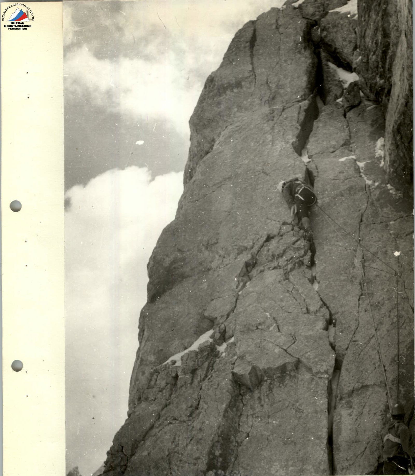
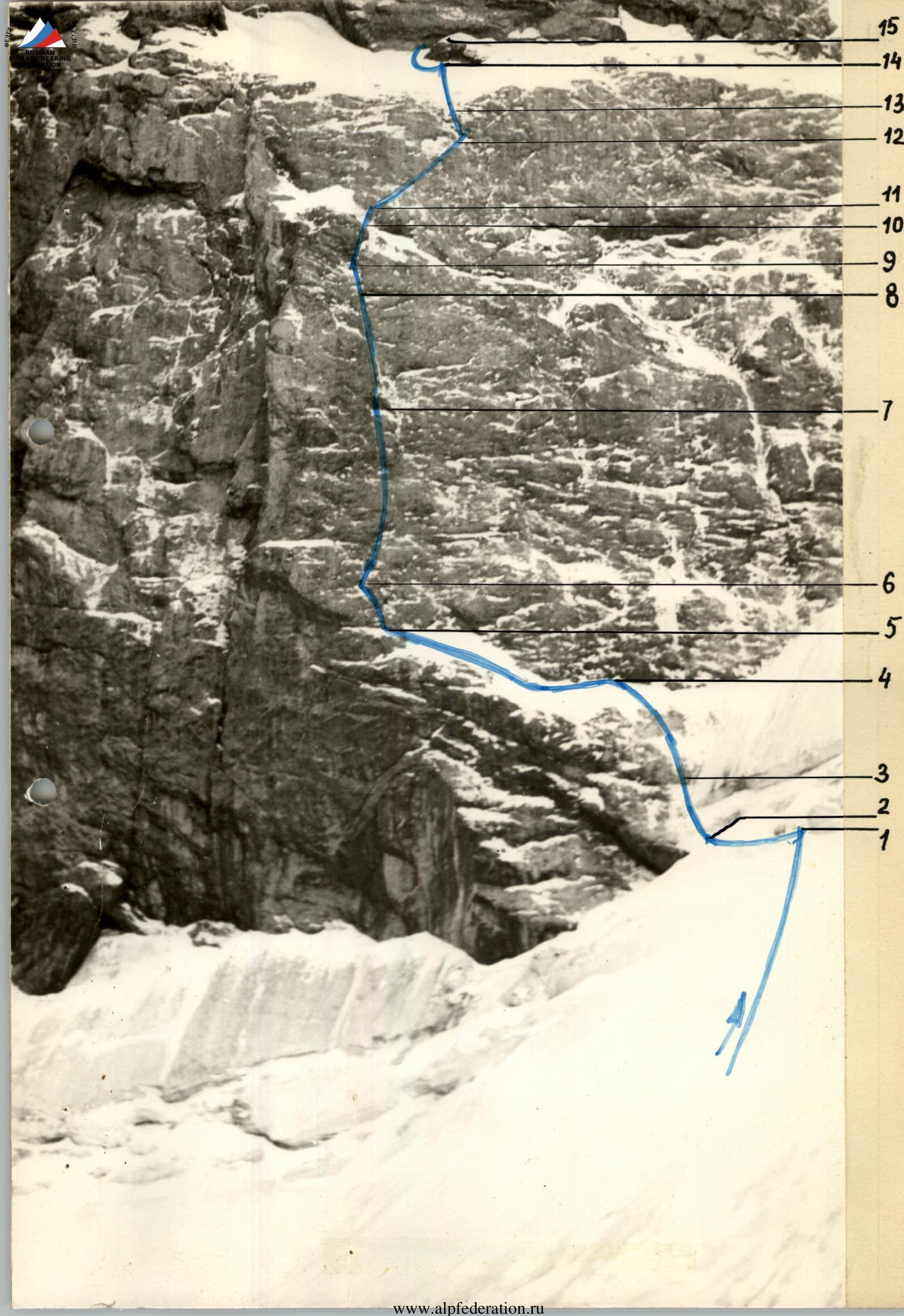
Photo 8. Ascending the outcrop (section R17)
After all the backpacks are delivered to the top of the slope, two team members start preparing the platform under the tent (this takes about 3 hours), while the third member moves to the first rope team, carrying the freed ropes and removing intermediate pitons along the way.
The first rope team continues the ascent. The lead climber changes. The second climber belays the first, hanging on ladders. Sometimes a piton or wedge is hammered into an icy crack, and from experience, we know that such pitons can't remain reliable for long — they eventually melt out. We try to move off a ladder hung on such a wedge as quickly as possible. Our nerves and muscles are stretched to the limit.
The crack is interrupted by a steep ice and snow ledge. Everything is relative, after all. On this wall, we call a "ledge" a 50° ice slope. To make it look more like a ledge, we chop a "tub" in the ice. The wall above us is monolithic. Only at our feet are there a few cracks. We traverse the ice to the right, peeking around the "corner." Here, we have a choice. We can go up a short, wide vertical groove filled with ice and embedded rock fragments, but the groove is entirely blocked by a perfectly horizontal cornice. The cornice is like a spring roof, adorned with icicles.
Alternatively, we can go alongside it. To the right of the groove, there's a vertical rectangular chimney behind a granite pillar. The back wall of the chimney is ice, and the sides are completely monolithic rock.
No, we can't do it without a drill here, so we return to the groove. We need to chop steps. With the next strike, a crack sounds, and half of the ice axe remains in our hand, while the other half flies down like a boomerang. We've never heard steel clang against rocks before. The fragment embeds itself in the snow at the foot of the wall, never touching it on its way.
We just need to chop four more steps, and a hammer comes into play. The path under the cornice is cleared. That's it for today. The rope team, satisfied with their progress, returns to their teammates. They're struggling on the slope with a huge boulder that's in the way of setting up the tent. With our backs against the wall, we five push the boulder down with our legs. With a crash, it breaks into pieces and flies into the bergschrund. We hang the tent and settle in for the night, sitting.
August 16
We depart at 7:00. From the outcrop to the ice ledge, three team members set up a pulley system to pull up the backpacks, while the rope team approaches the cornice with icicles. The cornice needs to be traversed on the right, where there's a crack. But the crack is filled with ice. A wooden wedge is jammed into a wide crack in the "ceiling" above our heads. A ladder is attached to it (photo R14). After a meter, another wedge, and another ladder (photo R15).
The helmet knocks off several icicles, and one of the shards goes down our back. A cold trickle runs down our spine.
We use plumber's tricks: a channel piton is used as a chisel to clear ice from the crack.
Another wedge is hammered in, followed by a channel piton, and finally, our heads rise above the cornice. Another 2 meters, and we can catch our breath.
The final 25 meters (climbing of medium difficulty) lead us under a huge snow and ice patch. There's space for a tent here.
We continue working further:
- First, straight up through snow and rock outcrops under the rocks of the third belt,
- Then along the boundary of ice and rocks to a slab with a crack (photo R16).
We turn on the radio. It turns out that help is needed below to pull up the backpacks. The rope team descends and joins the "rigging" work. Finally, all backpacks are above the cornice. We transfer them higher and start preparing the platform. This time, it takes only 1 hour to set up the bivouac, and the platform turns out to be excellent. Tonight, we'll sleep lying down.
We have another half hour of daylight to:
- examine
- sketch the further route.
About 60 meters can be examined very carefully, but further on, there's a jumble of reddish cornices and huge overhanging blocks. What awaits us there?
August 17
At 7:30, the first rope team departs. After climbing 65 meters on rappel ropes, they approach the base of a rising slab. The slab has a zigzagging crack
 At first, the crack is wide, but it narrows as we climb (photo R17). After 45 meters, it leads to the left edge of the slab. Then, the crack turns upward to the right and becomes very narrow. After 7 meters, it leads to an internal corner. The corner rises 30 meters in an ice-filled groove. Above the groove is steep ice under drifted snow. We move left and upward along the boundary of ice and rocks. We chop steps in the ice and hammer pitons into the rocks. This 40-meter section ends under a huge cornice. We'll bivouac here. Before we can stick the tent in place, we break off protruding sharp rocks. We'll have to spend the night sitting again.
August 18
At 6:30 in the morning, we contact the observers. We ask them to take a closer look through binoculars at what's ahead of us. The observers report that, as they see it, the climbing should be easier after the cornice.
For the first time on this route, the lead climber wears galoshes. We bypass the massive cornice hanging over us on the left. A horizontal crack filled with ice runs left along the wall. By hammering pitons into this crack, we traverse an extremely difficult section (photos R18, R19, R20). But instead of the "easier" climbing promised by the observers, we're faced with a 30-meter smooth sheer drop. There are very few handholds, and we use ladders again. We reach a small ledge. Here, we leave the second control cairn. The next section is 40 meters. It's also steep, but there are significantly more handholds here. The climbing is difficult but reliable. We reach a large rock spall. It's 1 meter away from the wall, making it very convenient for belaying.
But above our heads, there's another cornice. Steep rocks lead under the cornice (photo R21).
After overcoming the cornice, we find ourselves on another sheer drop. This is the base of the 150-meter tower (fourth belt), leading to the short north ridge. Again, we have to press ourselves against the rocks. From below, it seemed like it should be much easier!
The rope team radios down that they should prepare the bivouac site behind the spall, and they continue moving upward — they're storming the final bastion. They manage to climb another 70 meters. This is a steep section with three small cornices. The rock relief varies:
- At first, there are many reliable handholds, and we can climb using free climbing even through the cornices.
- Then, the rocks become more monolithic and smoother.
- Even higher, there are mirror-like slabs.
We secure the end of the rope and descend to the spall. Here, work is in full swing:
- Between the spall and the wall, we chop away ice.
- Then, the ice axe digs into angular shale.
- We relatively easily level the platform and hang the tent on it.
We spend the night sitting.
August 19
We pack up in silence, but a hidden excitement is palpable in each of us — the proximity of the summit is felt. We climb on the secured ropes (photo R22), then overcome a couloir. Its length is not great, just 10 meters, but its steepness and the ice coating require a significant expenditure of time and effort.
Beyond the couloir are monolithic rocks with few cracks and handholds. The 60-meter section is climbed by the first team wearing galoshes, mostly relying on friction. Then:
- 100 meters of climbing on rocks of medium difficulty,
- a 5-meter traverse
lead us to the top of the tower. And here — a nearly horizontal platform several meters wide! The rest of the path to the summit is visible.
It takes about 1 hour to create an ideal platform for the tent.
August 20
We leave the third control cairn on the platform and begin moving along the snow ridge at 8:00. Then, between rock outcrops and on them, we enter the pre-summit ridge (photo R23). It's initially snowy — steps are kicked in with the toe of the boot — and then ice is exposed — steps need to be chopped. The belay is through pitons. Then, a snowy slope leads us to the summit. At 10:30, we're all on the summit. We retrieve a note from a group of Leningrad climbers from the cairn. The weather is perfect. The mood is excellent.
The descent is familiar to the team leader; a month ago, he descended this route with a group of разрядники, and in 5 hours — we're at the observers' tents.
The next day, we head down...
General Characteristics of the Route
The north wall of v. Zindon is a slope with an overall steepness of about 75° and a length of over 1000 meters.
The route is logical and diverse in terms of relief forms, including:
- rock sheer drops,
- cornices,
- snow and ice slopes.
This route is complex throughout its entire length and requires climbers to master the full arsenal of mountaineering techniques.
The average steepness of the rock sections is around 75–80°, but many sections are sheer or close to it. Significant difficulties during the ascent are posed by the ice coating on the slab-like sections of the route, which:
- clogs all cracks,
- complicates climbing and belaying.
However, the entire route is completed without the use of bolt pitons, which increases its mountaineering value.
The first and second rock belts are best climbed in rubber-soled boots due to the abundance of ice.
The route requires good physical and moral-volitional preparation and can be recommended to a strong team with excellent rock climbers.
Most of the route is protected by a system of powerful cornices, making the route and bivouacs practically safe from rockfall. The only rockfall hazardous section is the snowy slope and the bergschrund area. This section requires increased attentiveness during the ascent.
Considering the need for a large number of pitons, carabiners, and ladders, it's advisable to use lightweight gear on the route. Comparing the route via the north wall of Zindon to previously climbed routes of the sixth category of difficulty, we can confidently say that:
- in terms of the steepness of individual sections and the overall steepness of the entire route,
- in terms of the number of sections with extremely difficult climbing
— it significantly surpasses them, and that it is a route of the highest category of difficulty.
Observation of the Team and Radio Communication
The observation group was located under the wall with the following composition:
- Zvyozdkin A.S. — team leader
- Martynov I.I. — Candidate for Master of Sports
- Maksimov A.I. — 2nd sports category
The observers saw the team on the route daily throughout the entire daylight period and kept a log of observations and radio communication.
Radio communication was carried out:
- Using the "Nedra-P" radio station, the group communicated with the "Artych" alpine camp.
- Communication between the climbers and observers was carried out using the "Vitalka" radio station.
- Communication among the participants was maintained using the "Vitalka" radio station.
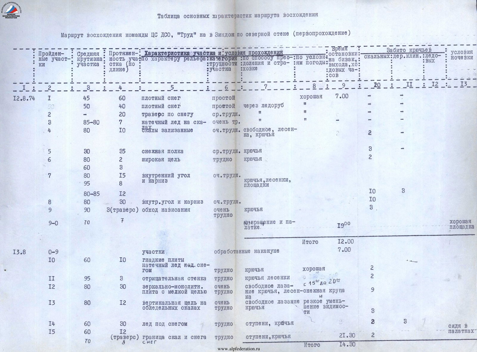
Table of Main Characteristics of the Ascent Route
Ascent route of the CS DSO "Trud" team to v. Zindon via the north wall (first ascent)
| Sections Climbed | Average Steepness of Section | Section Length (along the slope) | Section Characteristics by Relief Type | Climbing Conditions: Section Difficulty Category | Method of Climbing and Belaying | Weather Conditions | Time of Bivouac, Departure, Climbing Hours | Pitons Used: Rock | Wooden Wedges | Ice | Bivouac Conditions |
|---|---|---|---|---|---|---|---|---|---|---|---|
| 12.08 | |||||||||||
| R1 | 45° | 60 m | dense snow | easy | good | 7:00 | |||||
| R1 | 50° | 40 m | dense snow | easy | via ice axe | " | " | ||||
| R2 | 20° | 20 m | traverse on snow | medium | " | " | " | ||||
| R3 | 85–80° | 7 m | ice on rocks | very difficult | " | " | " | ||||
| R4 | 80° | 10 m | "slick" rocks | very difficult | free climbing, ladders, pitons | 2 | |||||
| R5 | 30° | 35 m | snow ledge | medium | pitons | 3 | 2 | ||||
| R6 | 80° | 2 m | wide crack | difficult | pitons | ||||||
| R6 | 60° | 3 m | |||||||||
| R7 | 80° | 15 m | internal corner and cornice | very difficult | pitons, ladders, platforms | 10 | 3 | ||||
| R8 | 80–85° | 12 m | internal corner and cornice | very difficult | 10 | 3 | |||||
| R9 | 90° | 3 m | (traverse) bypassing the overhang | very difficult | pitons | ||||||
| R9–R0 | 70° | 7 m | return to the tent | 19:00 | good tent | ||||||
| Total | 12:00 | ||||||||||
| 13.08 | |||||||||||
| R0–R9 | sections processed the day before | 7:00 | |||||||||
| R10 | 60° | 10 m | smooth slabs, ice under snow | difficult | pitons | good | 2 | ||||
| R11 | 95° | 3 m | negative wall | difficult | pitons, ladders | S | 2 | ||||
| R12 | 80° | 30 m | mirror-monolithic slab with a fine crack | very difficult | free climbing, pitons, ladders | 15–20° snow grains | 9 | ||||
| R13 | 80° | 12 m | vertical crack on icy rocks | very difficult | free climbing, pitons | reduced visibility | 3 | ||||
| R14 | 60° | 30 m | ice under snow | difficult | steps, pitons | 3 | 3 | sitting in tents | |||
| R15 | 60° | 12 m | (traverse) boundary of rocks and snow | difficult | steps, pitons | 21:30 | 2 | 8 | |||
| R15 | 70° | 8 m | snow | ||||||||
| Total | 14:30 | ||||||||||
| 14.08 | |||||||||||
| R16 | 50° | 40 m | snow, ice | difficult | steps, pitons | good | 7:30 | 3 | 3 | ||
| R17 | 80° | 25 m | slab with a crack | very difficult | pitons, ladders | 5 | 1 | ||||
| R18 | 70° | 15 m | rock blocks | difficult | pitons | 2 | |||||
| R19 | 90° | 7 m | (traverse) smooth wall | very difficult | 2 | ||||||
| R20 | 75° | 13 m | rocks covered in ice | very difficult | 2 | ||||||
| R21 | 45–60° | 45 m | diagonal steep ledge, ice, snow, rocks | medium | pitons, steps, free climbing | 7 | 2 | ||||
| R22 | 85° | 25 m | wall | very difficult | pitons | 5 | |||||
| R22–R16 | descent to the tent | 18:30 | sitting in the tent | ||||||||
| 15.08 | Total | 11:00 | |||||||||
| R16–R22 | section processed on 14.08 | ||||||||||
| R23 | 90° | 40 m | sheer drop with a vertical crack and small cornices | very difficult | pitons, ladders, platforms | good | 18 | 6 | |||
| R24 | 50° | 7 m | steep ice ledge | steps, pitons | 2 | ||||||
| R25 | 85° | 5 m | groove with ice coating | very difficult | steps, pitons | 2 | |||||
| R25–R15 | return to the small bivouac | 19:00 | sitting in the tent | ||||||||
| Total | 11:30 | ||||||||||
| 16.08 | |||||||||||
| R15–R25 | 90–95° | section processed on 15.08 | good | 7:00 | |||||||
| R26 | 2 m | (traverse) cornice with icicles | very difficult | pitons, ladders | 1 | 4 | |||||
| R27 | 60° | 25 m | couloir filled with snow | difficult | pitons | 3 | |||||
| R28 | 45° | 40 m | snow, ice, rock outcrops | medium | steps, belay through pitons and outcrops | 1 | 1 | ||||
| R29 | 50° | 25 m | boundary of ice and rocks | medium | steps, pitons | 3 | 1 | ||||
| R29–R27 | descent under the snow and ice patch | 18:00 | good tent | ||||||||
| Total | 11:00 | ||||||||||
| 17.08 |