Ascent Passport
I. Ascent class — technical 2. Ascent area — Pamir-Alay, Eastern Fan Range 3. Zamok (5070 m) — via the shortest path from the wall 4. Proposed complexity category — 5B 5. Height difference of the wall section — 950 m Length of the wall section — 1115 m Total route length — 1675 m Length of sections with IV–VI complexity category — 890 m, including VI category — 275 m. Average wall slope — 67°
- Pitons driven:
- rock: III/5
- bolt: 2
- chock: II5/5
- ice: I
- Team's moving hours: 20.5 hours (2 days)
- Overnight stays: lying in a tent. The overnight stay was set up by the team.
- Team: AUSB "Varzob" UA VS DSO "Profsoyuzov"
- Leader: Rusyaev Alexey Vasilievich — MS
Participants:
- Igolkin Viktor Ivanovich — MS
- Kirievsky Gennady Pavlovich — CMS
- Lapko Alexander Vladimirovich — CMS
- Odintsov Alexander Nikolaevich — MS
- Rykshin Vladimir Veniaminovich — CMS
II. Team coach: MS USSR Glushko Vyacheslav Ivanovich
12. Exit to the route: August 10, 1987
Exit to the summit: August 11, 1987
Return: August 11, 1987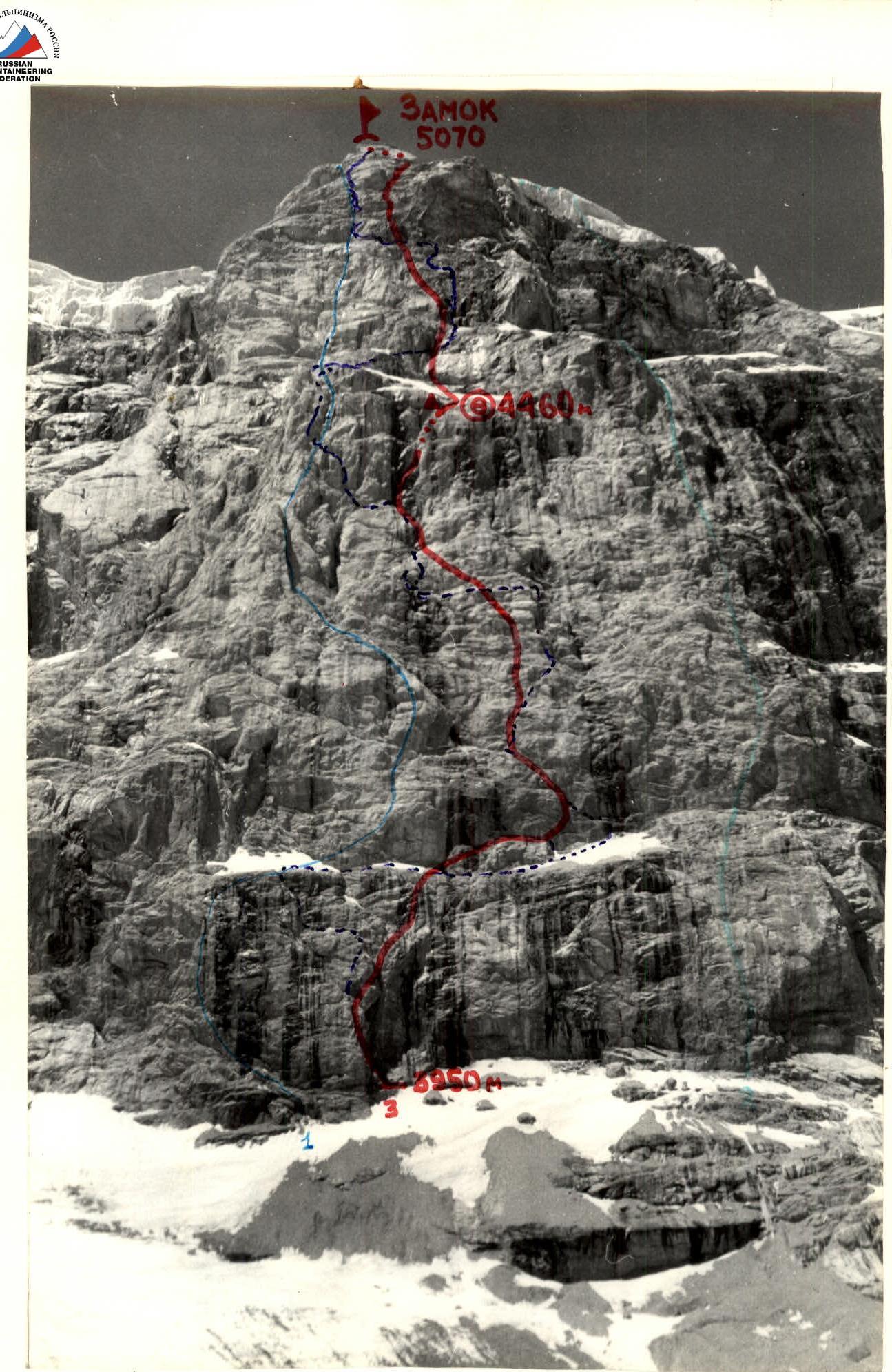
Photo — 1. Date taken — August 10, 1987. Lens — Industar-52. Route 1 — Shramko G. Drawn with errors, see p. 13. Yushkevich V.
Participants:
- Plotnikova A.
- Rusyaev A.
ROUTE PROFILE TO ZAMOK PEAK (5070 m) VIA THE SHORTEST PATH ON THE NNE WALL (View from the right)
Distance — 700 m. Shooting height — 3800 m. Shot number — 2.
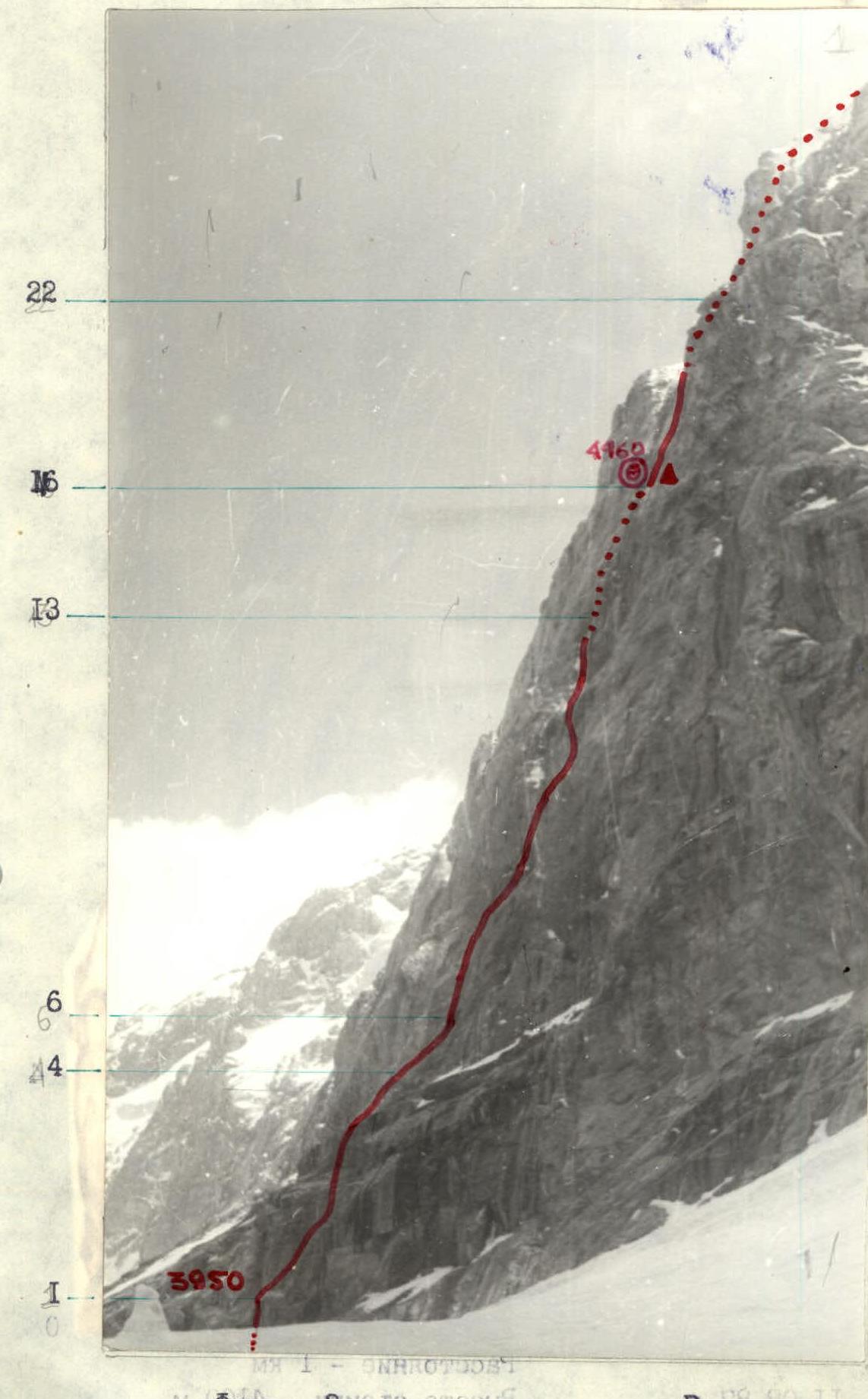
ROUTE PROFILE TO ZAMOK PEAK (5070 m) VIA THE SHORTEST PATH ON THE NNE WALL (view from the left)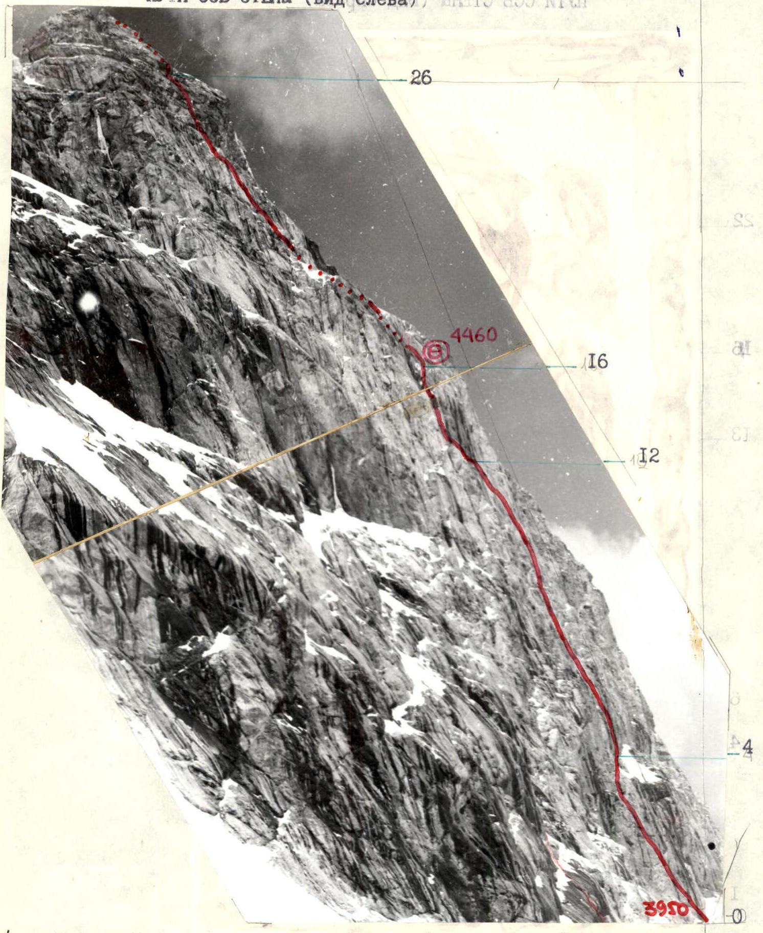
Photo — 3. Date taken — August 11, 1987. Lens — Industar-52.
Distance — 1 km. Shooting height — 4100 m. Shot number — 3.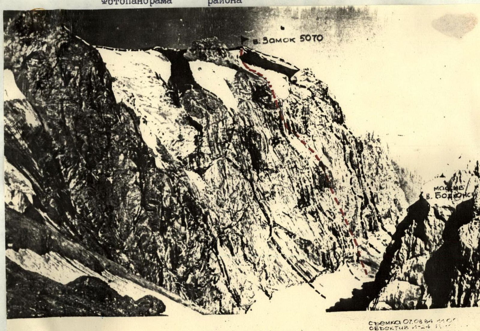
Tactical Actions of the Team
The start date of the ascent — August 10, 1987 — was determined by the regulations of the USSR Championship, as well as the need to coordinate actions with the team "Moldavian SSR", going on a parallel route (a variant of Shramko's route). On August 8, 1987, a weather forecast was received via radio communication, indicating a deterioration in weather on August 10–11, 1987, which forced the team to plan a three-variant tactical plan, taking into account different degrees of weather deterioration and route conditions, as well as reserve equipment and supplies. Due to normal weather conditions (the weather deteriorated 2 hours before reaching the summit), the first variant of the tactical plan was implemented. This variant involved passing the route with one overnight stay above the middle of the wall section and reaching the summit on the second day at 17:00. In case of bad weather:
- the second variant provided for two overnight stays (under the "finger" and under the upper bastion);
- the third variant — three overnight stays, when it would be necessary to move along icy rocks in poor weather conditions.
The route was completed from August 10 to 11, 1987, with an exit to the summit at 16:30 in 20 hours 30 minutes of moving hours, in accordance with the planned time schedule for days and sections of the route. Considering the strong and even team composition and the variability of the tactical plan, the work of the leading rope teams was organized by sections:
- on the 1st day — the Rusyaev-Odintsov rope team;
- on the 2nd day — the Kirievsky-Lapko rope team;
- on the 3rd day — the Igolkin-Rykshin rope team.
Due to the uniformity of the route (the average steepness and complexity approached the maximum), the following tactics were applied throughout:
- the first climber, ascending, organized the rope fixings, along which the other rope teams moved;
- the second rope team carried equipment and leveled the rope fixings;
- the third rope team dismantled them.
All participants were provided with double insurance: a rope fixing and lower (upper) insurance through intermediate points with an "Elita" rope (FRG, UIAA). The first climber worked in galoshes. The direction of movement and points of rope fixing, insurance organization were chosen from a safety perspective. The route was mainly passed by free climbing. The key sections of the route on the first day were:
- a vertical smooth slab with a crack and a cornice (sect. R10–R11);
- an overhanging internal corner-chimney with a waterfall and ice formation (sect. R13–R15).
This section, called the "finger" by the team, was overcome by a "pendulum" swing on a driven bolt hook and a single use of ITO. The key section of the second day was the upper bastion with overhanging rocks and cornices (sect. R21–R22, R24–R27). The direction of movement on the macro-relief was organized to ensure the shortest path to the summit, which was the first ascent via the NNE wall. The bivouac equipment was designed for joint and separate overnight stays. The bivouac was organized on a good scree ledge, protected from hanging ice icicles at the upper bastion — behind an overhanging wall (sect. R16). The movement regime along the route was continuous.
— The descent from the summit — first east along the ridge, then south along snowy and scree slopes and further along the trail to the base camp.
Safety measures for the route passage were:
- high individual physical, technical, and psychological preparation of team members;
- correct tactical plan;
- material support, including modern equipment;
- availability of modern equipment — ice axes, in case of icing of the upper part of the route and descent;
- presence of a qualified safety group under the route with a team doctor, having a specific plan of action in case of an emergency situation.
Observation of the team was carried out using 12x binoculars. Communication with observers via "Lastochka" radio was regular and stable. On the route, two hot meals and "pocket" food were provided throughout the day from high-calorie natural products at a rate of 350 g per person per day for four days.
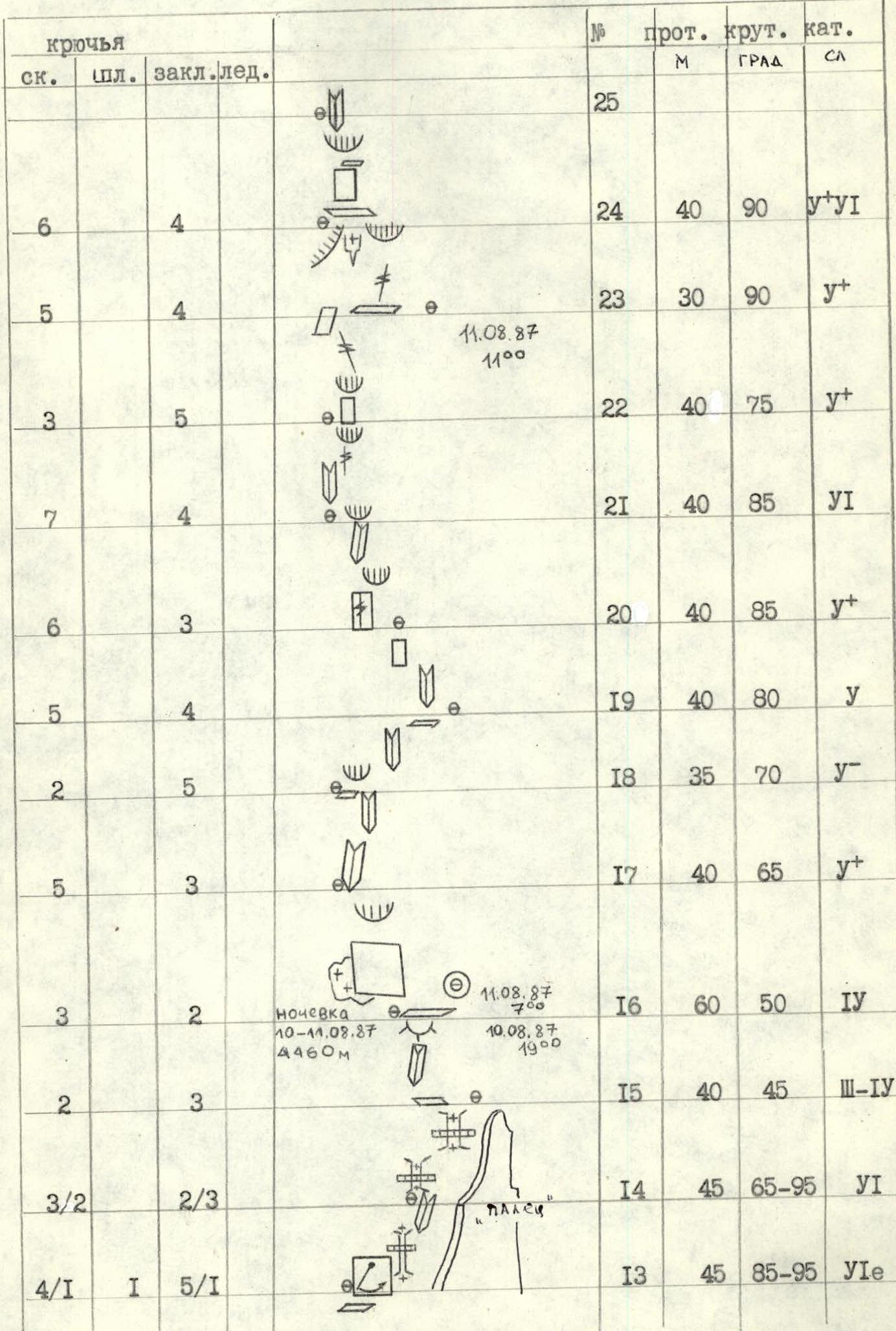
Route diagram in UIAA symbols M 1:20000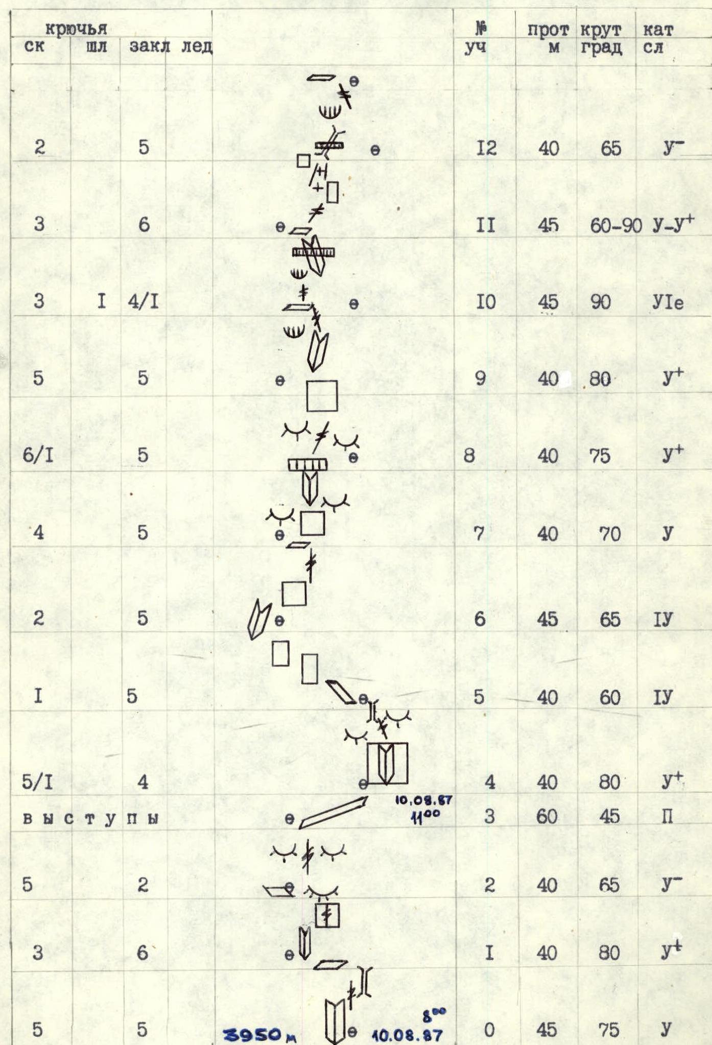
| Rock | Bolt | Chock | Ice | Sect. | Length, m | Slope, deg | Complexity cat. | Notes |
|---|---|---|---|---|---|---|---|---|
| 5 | 5 | R0 | 45 | 75 | 5 | |||
| 3 | 6 | R1 | 40 | 80 | 5 | |||
| 5 | 2 | R2 | 40 | 65 | 5 | |||
| ledges | R3 | 60 | 45 | 2 | ||||
| 5/1 | 4 | R4 | 40 | 80 | 5 | |||
| 1 | 5 | R5 | 40 | 60 | 4 | |||
| 2 | 5 | R6 | 45 | 65 | 4 | |||
| 4 | 5 | R7 | 40 | 70 | 5 | |||
| 6/1 | 5 | R8 | 40 | 75 | 5 | |||
| 5 | 5 | R9 | 40 | 80 | 5 | |||
| 3 | 1 | 4/1 | R10 | 45 | 90 | 6 | ||
| 3 | 6 | R11 | 45 | 60–90 | 5 | |||
| 2 | 5 | R12 | 40 | 65 | 5 | |||
| 4/1 | 1 | 5/1 | R13 | 45 | 85–95 | 6 | "Finger" | |
| 3/2 | 2/3 | R14 | 45 | 65–95 | 6 | |||
| 2 | 3 | R15 | 40 | 45 | 3–4 | |||
| 3 | 2 | R16 | 60 | 50 | 4 | Overnight stay (10–11.08.1987, 4460 m) | ||
| R17 | 40 | 65 | 5 | |||||
| 2 | 5 | R18 | 35 | 70 | 5 | |||
| 5 | 3 | R19 | 40 | 80 | 5 | |||
| 6 | 3 | R20 | 40 | 85 | 5 | |||
| 7 | 4 | R21 | 40 | 85 | 6 | |||
| 3 | 5 | R22 | 40 | 75 | 5 | |||
| 5 | 4 | R23 | 30 | 90 | 5 | |||
| 6 | 4 | R24 | 40 | 90 | 5–6 | |||
| 6 | 4 | R25 | 40 | 65 | 6 | |||
| 6 | 5 | R26 | 40 | 80 | 6 | |||
| 4 | 5 | R27 | 40 | 70 | 3–2 | |||
| 1 | R28 | 50 | 20–30 | 2 | ||||
| R29 | Summit (11.08.1987, 16:30) |
Route Description by Sections
1st day. August 10, 1987. Section R0. The route begins along an external corner with smoothed walls. The vertical crack is bypassed on the left. 45 m, 75°, 5 complexity cat. Section R1. From a convenient ledge for insurance organization, move right-up along an internal corner to a vertical wall with a crack. 40 m, 80°, 5 complexity cat. Section R2. "Ram's foreheads" with a crack leading to a scree ledge. 40 m, 65°, 5 complexity cat. Section R3. Along the ledge, traverse right. Insurance is organized using ledges. 60 m, 2 complexity cat. Section R4. From the ledge, move left onto a wall with an internal corner. Good friction. The internal corner leads to smoothed rocks with a crack, further turning into a chimney. Places for insurance organization are limited. 40 m, 80°, 5 complexity cat. Section R5. Smoothed walls, alternating with ledges. 40 m, 60°, 5 complexity cat. Section R6. A heavily destroyed internal corner, turning into a monolithic rock wall at the top. 45 m, 65°, 4 complexity cat. Section R7. A slab with a monolithic internal corner, with steepness reaching vertical at the top. 40 m, 75°, 5 complexity cat. Section R8. A cornice with a 70 cm overhang is overcome by free climbing. Above the cornice — a monolithic smoothed slab with a crack. 40 m, 75°, 5 complexity cat. Section R9. A steep internal corner, bypassing a rusty overhang. 40 m, 80°, 5 complexity cat. Then traverse right along a 50 cm wide ledge, 20 m, 3 complexity cat. Section R10. Ascend along an overhanging crack by free climbing. Exit into an internal corner with a cornice in the middle part. ITO uses a bolt hook. 25 m, 90–95°, 6 ITO. Section R11. A monolithic wall is overcome left-up at an angle of 45°. Then enter a couloir, its walls are smoothed, mossy, and partly covered with ice. Water flows from above. In the right part of the couloir, a vertical chimney with a plug. 45 m, 60–90°, 5 complexity cat. Section R12. Ascend along the chimney, at the top — pass through an overhang and exit onto a gray monolithic slab. Overall direction of movement — left-up. 40 m, 65°, 5 complexity cat. Section R13. Ascend along a monolithic vertical slab right-up for 15 m. Here a bolt hook is driven for a pendulum swing right into a wet chimney with ice. In the middle part, the chimney overhangs. Climbing is extremely difficult. 45 m, 85–95°, 6 ITO. Section R14. A vertical, partly overhanging chimney. Ice is present at the bottom. Walls are wet. At the top, a plug. 45 m, 85–95°, 6 complexity cat.
2nd day. August 11, 1987.
Section R15. A strongly dissected internal corner, leading right onto a scree ledge under a rock bastion. A convenient place for overnight stay. Control tour. 40 m, 45°, 3–4 complexity cat.
Section R16. Move along smooth slabs with snow from right to left. Enter an internal corner along a small ledge. 60 m, 50°, 4 complexity cat.
Section R17. Move along internal corners filled with ice. Then along a 10-meter wall — exit onto a ledge under a cornice. 40 m, 85°, 5 complexity cat.
Section R18. The cornice is bypassed on the right along a crack, then along a steep wall — exit onto a ledge. Climbing is complex. Many loose stones. 35 m, 70°, 5 complexity cat.
Section R19. From the ledge, ascend along a sheer wall — 8 m with a minimal number of holds. Then move in balance along an inclined slab. 30 m, 75°, 5 complexity cat.
Section R20. A wall with a crack, and then a cornice are passed by free climbing. 20 m, 90°, 5 complexity cat. Then along an internal corner, ascend to a small ledge. 20 m, 80°, 5 complexity cat.
Section R21. An overhanging internal corner with few holds, climbing is extremely difficult. 10 m, 90°. Do not relax. Then a smooth slab with a crack rests against a cornice. Holds are small, smoothed. Friction is poor. 20 m, 80°, 6 complexity cat. The cornice is passed from left to right. Difficult, psychologically challenging. 10 m, 85°, 6 complexity cat.
Section R22. Then a slab leads under an overhang. 20 m, 70°, 5 complexity cat. The overhang is passed by free climbing. Climbing is complex. Then along a crack and a small "tooth". "Icicles" overhang on the left. 20 m, 80°, 5 complexity cat.
Section R23. A key place. Exit onto "icicles" in an arc from right to left. The wall overhangs. Holds are small. After 8 m, a crack begins. Passed by free climbing. 12 m, 95°, 5 complexity cat. Then traverse left onto a ledge. "Icicles" are below us.
Section R24. A smooth slab. 15 m, 90°, 5 complexity cat. Passed in the right part on friction. Holds are smooth. Difficult. Then a cornice with good holds and a crack entering an internal corner. 25 m, 90°, 6 complexity cat. Insurance is organized in a hanging position. Snow started falling, graupel.
Section R25. Along the internal corner for 8 m, 90°, 6 complexity cat. Through a cornice to the next internal corner with a crack. Passed by free climbing, there are loose stones. Careful climbing. 10 m, 90°, 6 complexity cat. Then a flattening. Along a smooth slab to a large cornice on the left. 20 m, 75°, 5 complexity cat.
Section R26. Before us is a wall 10 m, 80°, 5 complexity cat., leading under a cornice. The cornice ends with a smooth slab at the top. Holds are sloping. "Khookonogi" are used. 10 m, 90°, 6 complexity cat. Then right to an internal corner with a crack. 20 m, 70°, 6 complexity cat. Rocks are unstable, wet. The pre-summit tower is visible.
Section R27. Along wet, unstable rocks to the base of the pre-summit tower. 40 m, 70°, 5 complexity cat. Fog. Snowfall.
Section R28. Along an ice-snow slope 20–30° exit onto a ridge and further along the ridge to the summit at 16:30. There is no note in the summit register. Fog, snow, graupel. Leave our note and descend along the eastern ridge towards Pahamber peak. Further descent along snowy slopes and scree on Cg, then along the trail to Alaudin lakes.
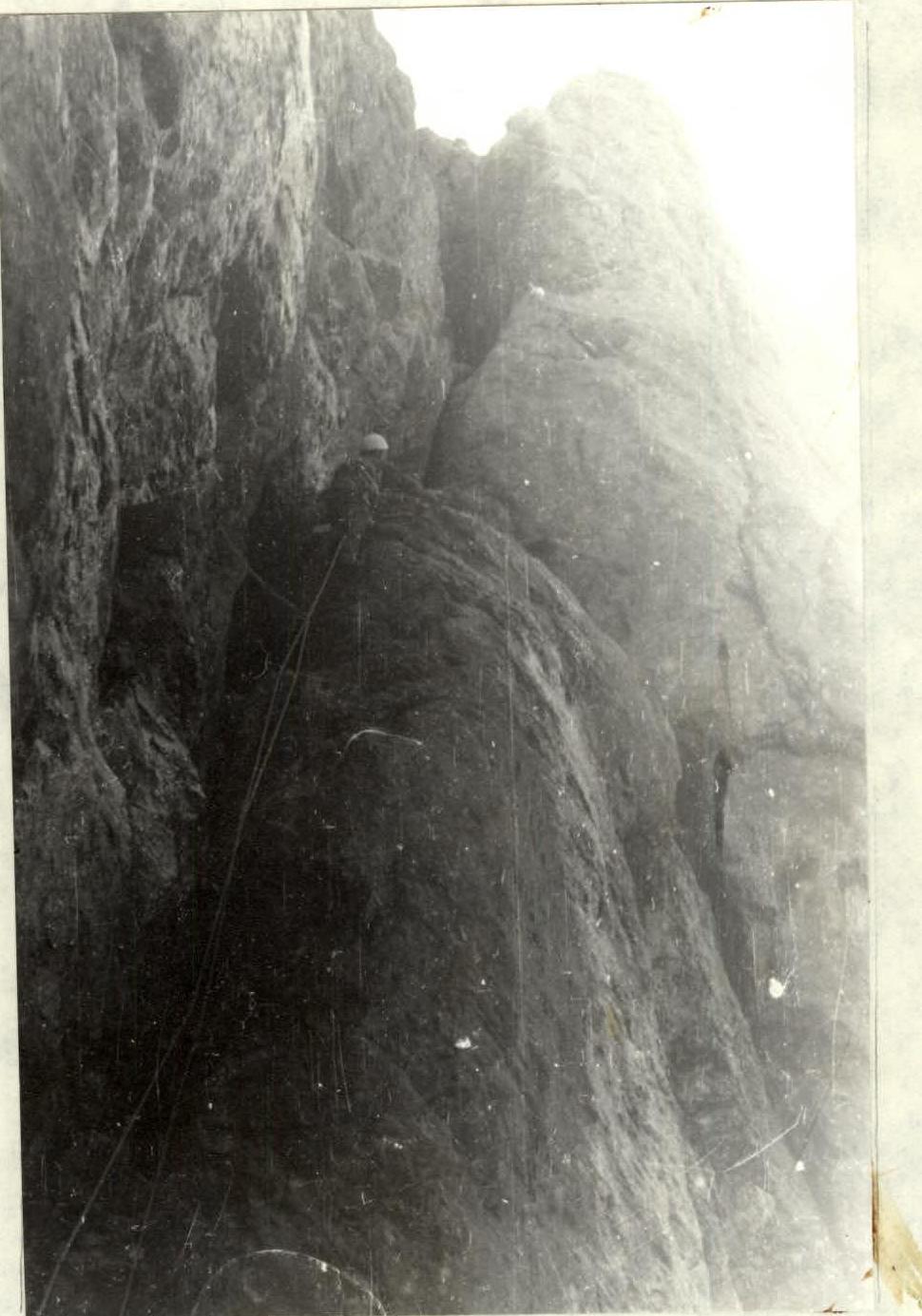
Photo — 7. Section R9–R10. Along an internal corner, bypassing a rusty overhang.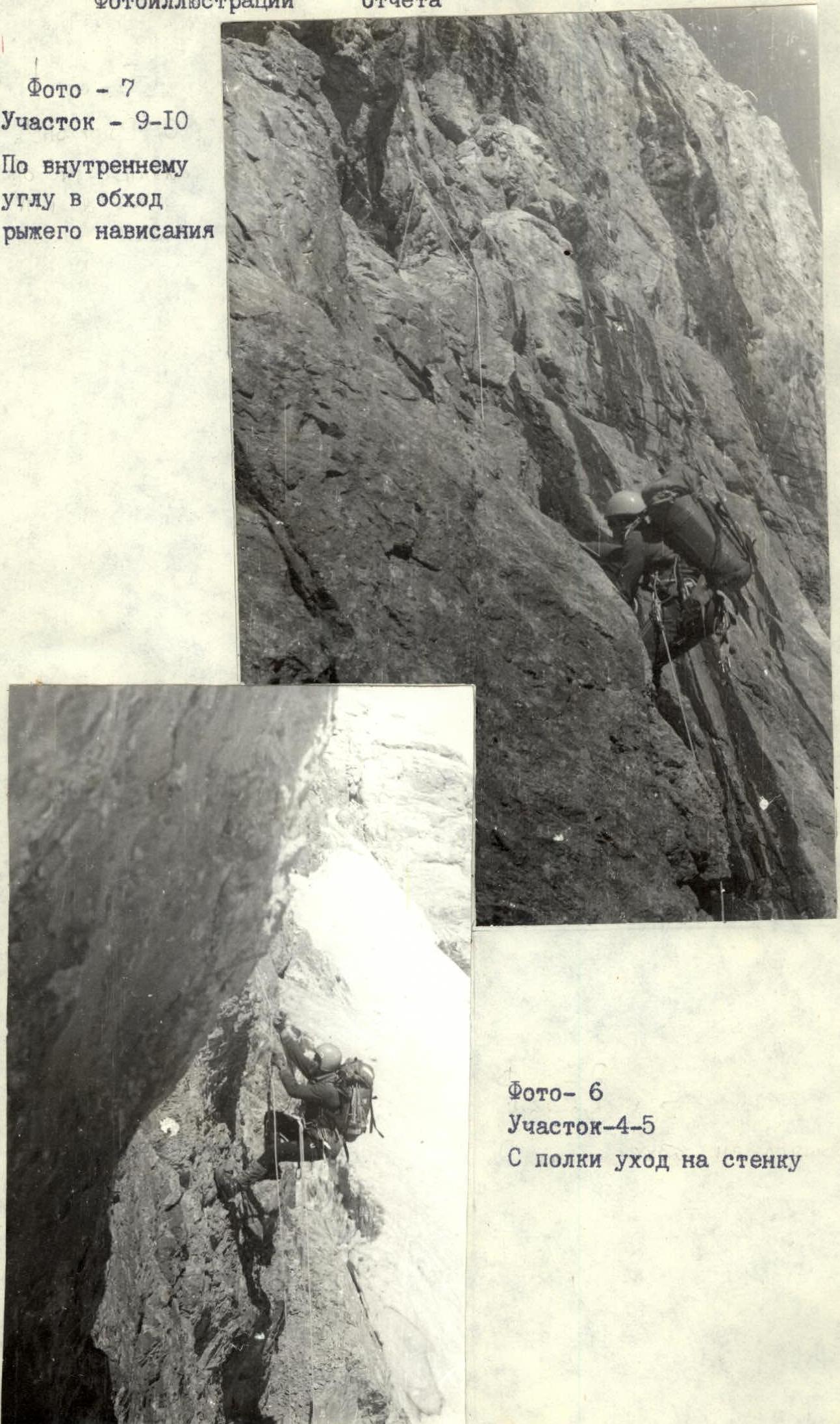 Photo — 8. Section R13–R14. Overcoming a wet chimney with ice.