Ascent Passport
- Ascent class: technical
- Ascent area: Pamir-Alai, Zeravshan Range
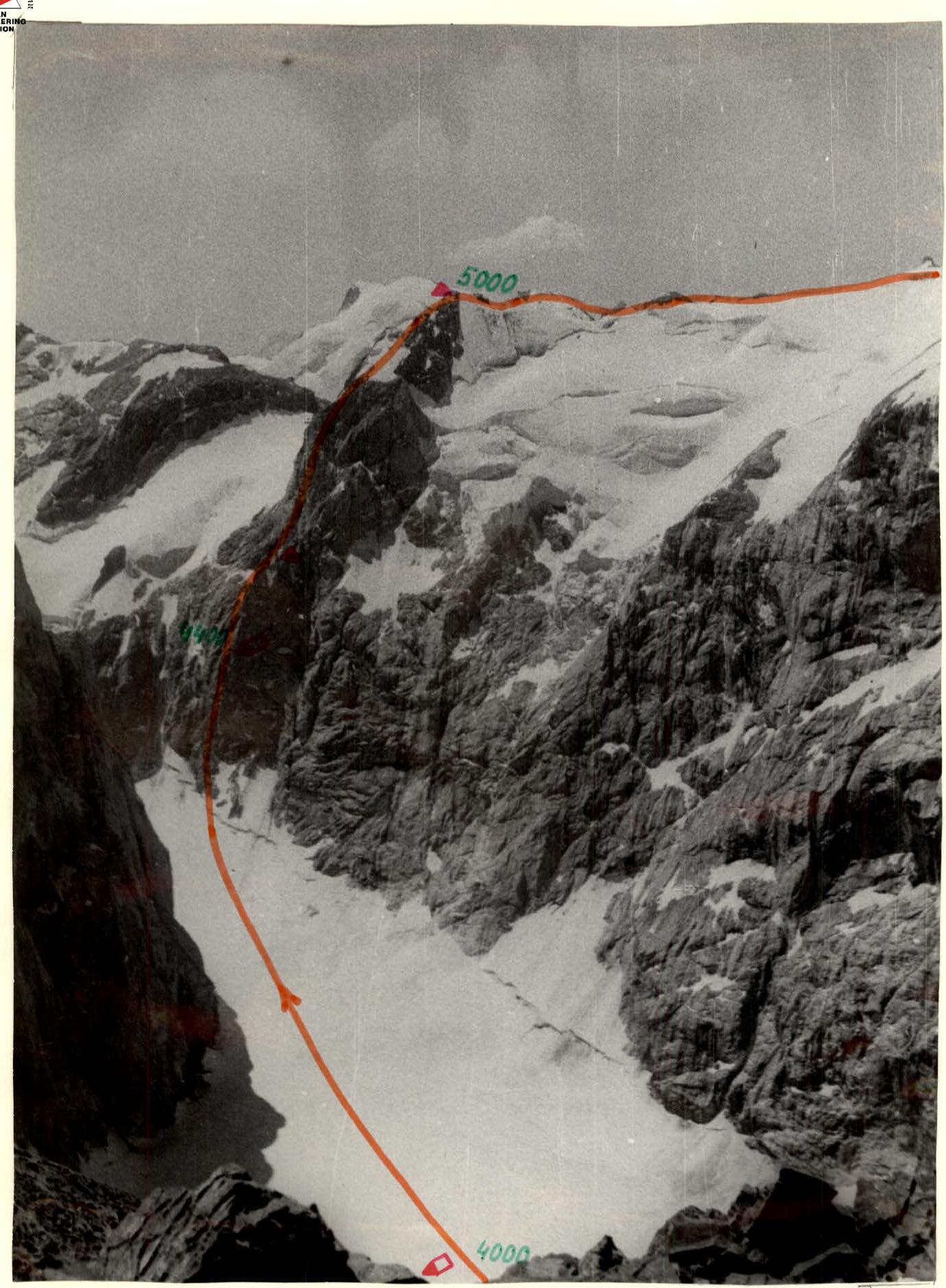
- Peak, its height, ascent route: Zamok, 5070 m, via the Eastern counterfort of the NNE wall, third ascent
- Proposed difficulty category: 5B
- Route characteristics: route length: 1100 m, height difference: 900 m, average steepness 70°, length of sections: fifth category – 280 m, sixth category – 35 m
- Pitons driven: for belaying, for creating ITO: rock 106, ice 2, bolt 1 (used someone else's)
- Number of climbing hours: 18 hours, climbing days – two
- Number of bivouacs and their characteristics: one – semi-reclining
- Team name: LOSSRSO "Burevestnik", SKB LIAP No.0.
- Participants' full names, their sports qualification: Barulin Boris Aleksandrovich, Candidate Master of Sports Khitrov Mikhail Vasilievich, Candidate Master of Sports
- Coach: Troshchinenko Leonid Andreevich, Master of Sports
- Date of departure on the route and return: July 9–10, 1979
Brief explanation of the main characteristics table, order of route passage
From the moraine site under the western wall of Bodkhona peak, it takes 40 minutes to approach the route. Steep firn slope. The route starts in the left part of the counterfort. (Section R0–R1) leads under the counterfort. From the randkluft through large-block rocks of medium difficulty (section R1–R2) – exit to a ledge. Along the ledge to the left 7 m to a vertical inner corner (section R2–R3), up the corner 15 m of difficult climbing, then through steep smoothed slabs (section R3–R4) and stepped rocks (section R4–R5) to the base of a steep inner corner (section R5–R6). After the corner, traverse right-up along a slab (section R6–R7) to the base of a rusty sheer wall. The wall is one of the key sections of the route. There are few cracks for driving pitons, the relief is smoothed. The wall (section R7–R8) is passed using ITO. Here, " закладки" are mainly used. The wall ends with smoothed slabs (section R8–R9). Along the slabs, we exit to a niche under a cornice. Above are several tiers of cornices. Maneuvering between cornices, the third cornice has to be overcome head-on, using ITO. We exit under a sheer narrowing chimney (section R10–R11). The base of the chimney is filled with ice. Using ITO, through the left part of the chimney – exit to the counterfort ridge. 50 m further, under the base of a rock wall, we find a triangular site for two, there is ice. Bivouac. From the site to the left along steep rocks (section R13–R14), then up-right to the counterfort ridge. Along the left side of the counterfort (section R14–R15), we exit to a snowy saddle in the ridge under the base of the second bastion, the first ascenders' site, control cairn. Time 11:00, snack. From here along a sheer, partly overhanging wall (section R15–R16) – exit to a rock gully (section R17–R18). The gully has many loose stones, rockfall hazard. Further left-up, crossing the gully, – exit to the counterfort ridge (section R18–R19). Along the left edge of the counterfort, through steep smoothed rocks – movement to the base of a destroyed wall (rockfall hazard), leading to the base of the summit tower (section R19–R20). Further along a wide inner corner turning into a cleft (very difficult climbing, few places for pitons) (section R20–R22) – exit to the summit rock outcrop. From there along a snowy, destroyed ridge (simultaneous movement) – 30 minutes to the counterfort summit. Sites, control cairn. This is the eastern summit of Zamok. A simple path along snowy and talus slopes leads to the main summit. At 16:00, we start descending into the Pайхамбер valley. At 18:00, the group returned to the camp on Bolshoe Alaudinskoye Lake.
Table of main route characteristics
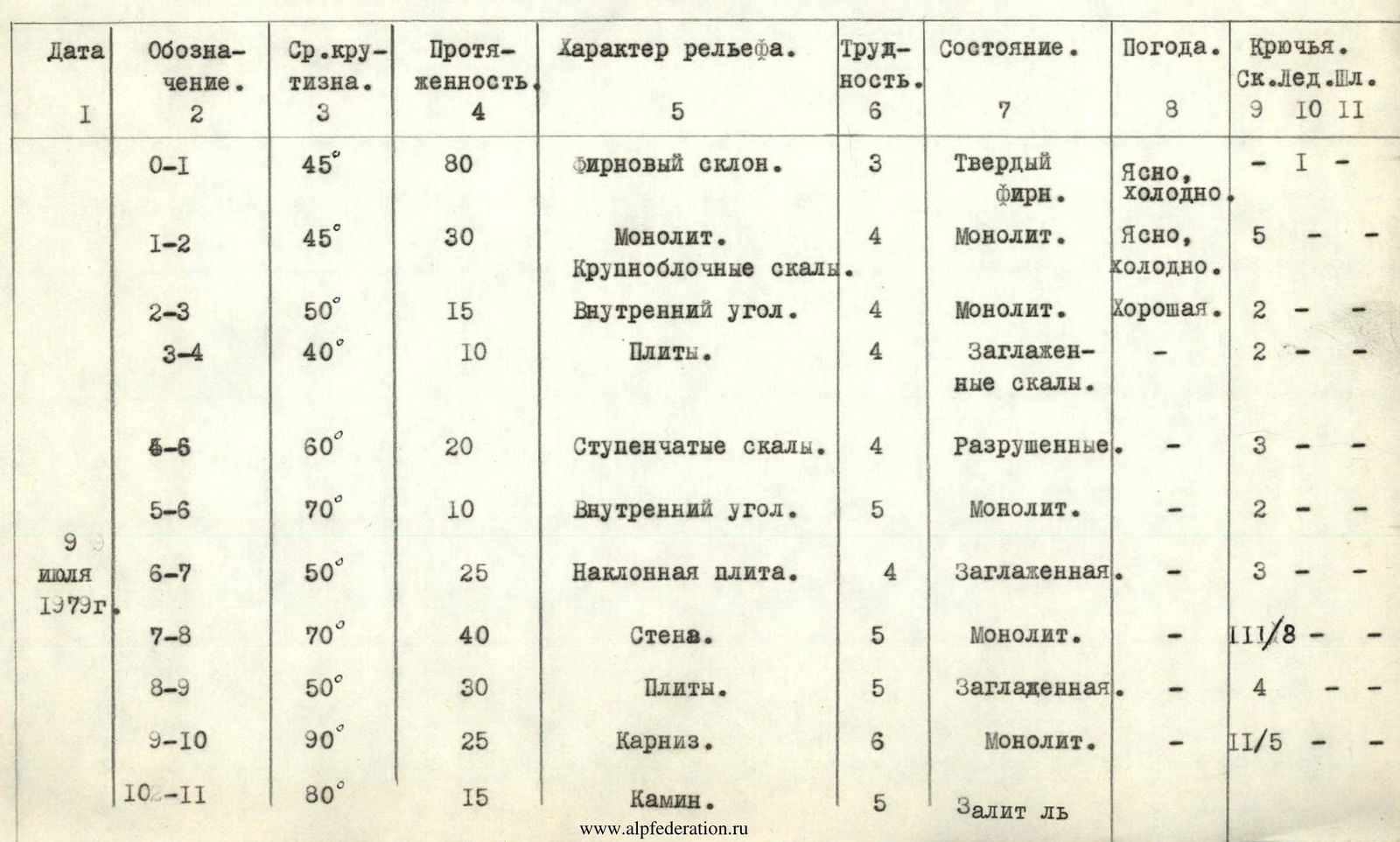
| Date | Designation | Avg. steepness, ° | Length, m | Relief character | Difficulty category of section | Condition | Weather | Rock pitons | Ice pitons | Bolt pitons |
|---|---|---|---|---|---|---|---|---|---|---|
| July 9, 1979 | R0–R1 | 45 | 80 | Firn slope | 3 | Hard firn | Clear, cold | - | 1 | - |
| R1–R2 | 45 | 30 | Monolithic. Large-block rocks | 4 | Monolith | Clear, cold | 5 | - | - | |
| R2–R3 | 50 | 15 | Inner corner | 4 | Monolith | Good | 2 | - | - | |
| R3–R4 | 40 | 10 | Slabs | 4 | Smoothed rocks | - | 2 | - | - | |
| R4–R6 | 60 | 20 | Stepped rocks | 4 | Destroyed | - | 3 | - | - | |
| R5–R6 | 70 | 10 | Inner corner | 5 | Monolith | - | 2 | - | - | |
| R6–R7 | 50 | 25 | Inclined slab | 4 | Smoothed | - | 3 | - | - | |
| R7–R8 | 70 | 40 | Wall | 5 | Monolith | - | 11/8 | - | ||
| R8–R9 | 50 | 30 | Slabs | 5 | Smoothed | - | 4 | - | - | |
| R9–R10 | 90 | 25 | Cornice | 6 | Monolith | - | 11/5 | - | ||
| R10–R11 | 80 | 15 | Chimney | 5 | Filled with ice | Good | 1/3 | - | - | |
| Departure time – 8:00 | ||||||||||
| Time of stopping for bivouac – 20:00. Climbing time for the day – 12 hours. Bivouac semi-reclining for two. | ||||||||||
| July 10 | R11–R12 | 45 | 25 | Slabs | 4 | Smoothed | - | 3 | - | - |
| R12–R13 | 45 | 50 | Counterfort | 4 | Destroyed | - | 5 | - | - | |
| R13–R14 | 80 | 30 | Wall | 5 | Monolith | Clear | 6 | - | - | |
| R14–R15 | 50 | 160 | Counterfort | 4 | Monolith | - | 12 | - | - | |
| R15–R16 | 80 | 30 | Wall | 5 | - | - | 1/5 | - | - | |
| R16–R17 | 100 | 10 | Cornice | 6 | - | - | 2/2 | - | - | |
| R17–R18 | 50 | 70 | Gully | 4 | Destroyed | - | 6 | - | - | |
| R18–R19 | 60 | 80 | Counterfort | 5 | Destroyed | Good | 10 | - | - | |
| R19–R20 | 60 | 60 | Stepped rocks | 4 | Destroyed | - | 8 | - | - | |
| R20–R21 | 75 | 20 | Inner corner | 5 | Monolith | - | 5 | - | - | |
| R21–R22 | 90 | 20 | Cleft | 5 | Monolith | - | 4 | - | - | |
| R22–R23 | 30–45 | 240 | Ridge | 3 | Snowy | - | 3 protruding | - | - |
Departure time – 7:00. Summit reached at 16:00. Climbing hours – 8 hours.
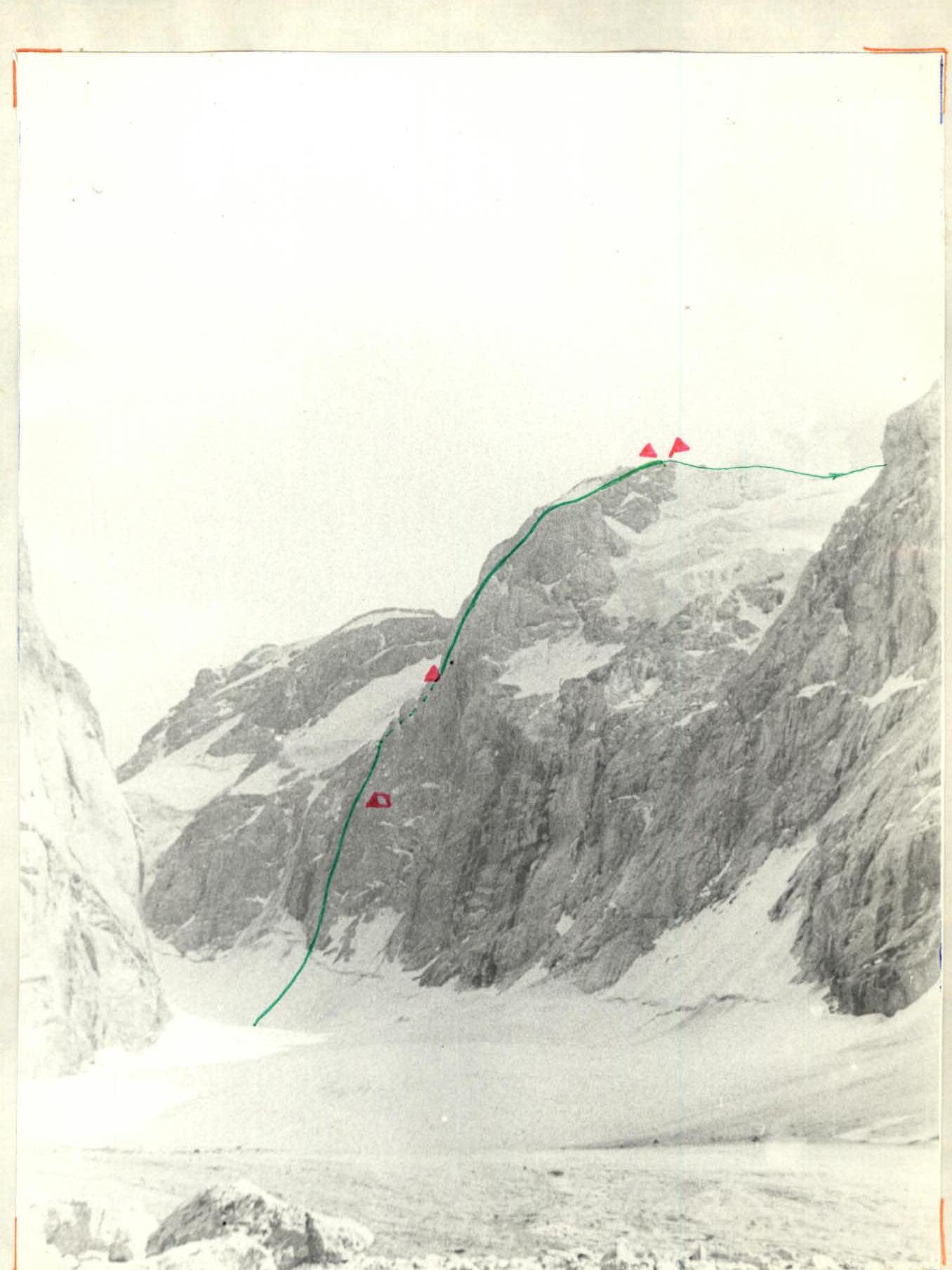
Route profile
Visible part of the route Invisible part