ASCENT DOCUMENT
- Climbing capsule: Skalny
- Climbing area, ridge: 5.3. Zaravshan ridge
- Peak, its height, ascent route: peak Diemar (4000 m) via the north face, category 5B difficulty
- Proposed difficulty category: 5B
- Route characteristics: height difference 900 m, length of sections with 5th-6th category difficulty 379 m
- Average steepness 66°
- Other removable protection points hammered:
- rock T22 — 38
- for creating intermediate anchor points (rock) — 7
- chocks — 4
- Number of climbing hours: 20
- Number of anchor points and their characteristics: one, details
- Surname, name, patronymic of the team leader, participants, and their qualifications
- Captain Apporov Vladimir Ivanovich — Master of Sports of the USSR
- Trebinov Dmitry Alekseevich — Candidate Master of Sports
- Rabinov Felix Grigorievich — Candidate Master of Sports
- Demidkova Elizaveta Dmitrievna — public sector worker
- Team coach: Ivanyov V.K.
- Dates of starting and finishing the route:
- July 14, 1960
- July 15, 1960
TABLE OF MAIN CHARACTERISTICS OF THE ASCENT ROUTE
on peak Diemar via the north face, category 5B difficulty, unclassified.
Height difference 3100–4000 m, +900 m. Including 800 m continuous wall with an average steepness of 68°.
Route length 1800 m, including 1200 m on the wall.
No piton hooks were used.
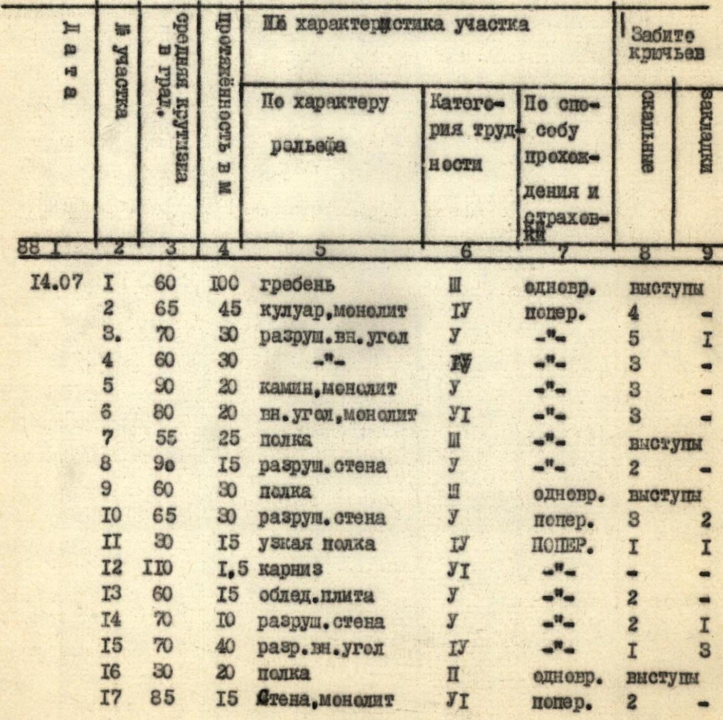
| Section No. | Date | Average steepness in degrees | Length in m | Terrain characteristics | Difficulty category | Method of passage and belay | Rock pitons hammered | Chocks |
|---|---|---|---|---|---|---|---|---|
| R18 | 50 | 15 | ledge | 3 | simultaneous | outcrops | ||
| R19 | 70 | 80 | dihedral, monolith | 5 | — | 2 | 5 | |
| R20 | 40 | 20 | broken ridge | 3 | — | 1 | outcrops | |
| R21 | 75 | 30 | wall | 5 | — | 4 | 2 | |
| R22 | 50 | 30 | ledge | 3 | simultaneous | 2 | outcrops | |
| R23 | 65 | 80 | edge | 4 | alternating | 4 | outcrops | |
| 15.07 | R24 | 60 | 60 | edge | 3 | simultaneous | 1 | 2 |
| R25 | 70 | 20 | wall | 5 | alternating | 3 | 2 | |
| R26 | 60 | 20 | edge | 4 | alternating | 1 | 1 | |
| R27 | 25 | 40 | wall | 5 | — | 7 | 5 | |
| R28 | 60 | 15 | broken wall | 5 | — | 3 | — | |
| R29 | 70 | 30 | wall | 5 | — | 5 | 2 | |
| R30 | 50 | 10 | slab, monolith | 4 | — | 2 | — | |
| R31 | 70 | 30 | wall | 5 | — | 5 | 2 | |
| R32 | 65 | 80 | dihedral | 5 | — | 10 | 2 | |
| R33 | 60 | 12 | slab, monolith | 5 | — | 2 | — | |
| R34 | 120 | 2,5 | overhang | 6 | — | — | — | |
| R35 | 65 | 15 | slab, monolith | 5 | — | 3 | 1 | |
| R36 | 80 | 30 | chimney | 6 | — | 6 | — | |
| R37 | 85 | 10 | wall, monolith | 6 | — | 2 | 1 | |
| R38 | 75 | 25 | crack | 6 | — | 3 | 4 | |
| R39 | 30 | 5 | ledge | 2 | — | 1 | — | |
| R40 | 100 | 15 | dihedral | 6 | — | 4 | — | |
| R41 | 80 | 20 | wall | 6 | — | 5 | — | |
| R42 | 30 | 5 | ledge | 2 | — | 1 | — | |
| R43 | 75 | 40 | wall | 5 | — | 5 | 1 | |
| R44 | 30 | 500 | ridge | 1 | simultaneous | — | — |
Total: On the first day: 716.5 m covered, 53 rock pitons hammered, 15 chocks placed. On the second day: 984.5 m covered, 69 rock pitons hammered, 23 chocks placed.
ROUTE PROGRESSION ORDER
August 13. According to the tactical plan, the approach to the route is completed. We set up a tent under a large rock, quickly prepare a hearty dinner, and it's time to sleep – tomorrow is an early start and a busy working day.
July 14. Morning. We had breakfast and packed our backpacks within 40 minutes. We start moving. After half an hour of walking up a dry riverbed, we reach the base of a destroyed ridge. The difficulty of this section allows us to move without being tied up, but in a tight group – it's safer. An hour of such climbing on the ridge – and we're under the wall. Stones are flying down a large couloir on the left, but they're not a threat to us. We quickly get dressed, tie ourselves together, and hang our pre-assembled gear.
8:00. Rabinov F. starts moving. About 100 m (R0–R1) of simultaneous movement along the ridge with belay through outcrops, which turns into a wall slightly to the left of a small rock amphitheater. 45 m (R1–R2) down the right side of the couloir into the amphitheater under an overhang. Pitons come into play.
The next 30 m (R2–R3) on a steep, heavily destroyed dihedral again lead under an overhang, which is bypassed on the right, and then along a moderately difficult dihedral to a small shoulder with a huge rock. Here we decide to leave the first control point.
While writing a note, the first climber continues working:
- 20 m of difficult climbing on the right wall of a chimney (R3–R4), which turns into a dihedral (R4–R5)
- We have to climb along the right monolithic side – very difficult climbing, with few places to hammer pitons
But these meters are overcome, the rope is secured – it's faster and safer this way.
Along a ledge (R5–R9) with a 15 m heavily destroyed wall almost in the middle, we move forward. It's already 11:45, and there's a convenient spot with water.
We decide to have a snack with hot tea. We plan to move at 13:30.
From this point, the path logically leads upwards to the left because:
- the ledge we're on ends, and stones are flying along it;
- 30 m wall (R9–R10) is heavily destroyed;
- the rocks are covered with clay, which doesn't facilitate quick passage.
Further to the right along a narrow ledge on icy rocks for 15 m (R10–R11). At the end of the ledge – a 1.5 m overhang (R11–R12) – extremely difficult climbing on wet monolithic rocks and then up to the left along a wet slab to the base of a destroyed wall (R12–R14). Above the wall begins a 40 m dihedral (R14–R15) of moderate difficulty, which we climb to a rocky shoulder and then along a scree slope to a 15 m steep monolithic wall (R15–R16). The limited number of small holds – extremely difficult climbing, despite the first climber's assistance; passing this section in the second rope requires the use of a fixed rope.
We move along moderately difficult rocks to the left under a large overhang to an inclined dihedral (R18–R19). Here we find a control cairn left by the first ascenders with a note from a lost group. This means we're on the right track.
We change the lead rope. Very difficult maneuvering along an 80 m monolithic dihedral, which constantly ejects rocks, leads to a destroyed ridge (R19–R20), followed by a very steep, heavily destroyed wall (R20–R21) – a handrail.
Further along a ledge 30 m to the right to a shoulder of the edge.
The weather starts to deteriorate: clouds appear, a cold wind picks up. Another 80 m up the edge (R21–R22) of moderate difficulty – and the weather is about to worsen. We decide to change our tactical plan and stop for the night at 18:00. We quickly set up a site and rush into the tent – it's starting to drizzle, which stops after 40 minutes, but it's too late to continue.
July 15. The morning is very cold, with strong winds. A brief deliberation – we decide that leaving at 8:00 is unreasonable. At 7:00, with the sunrise, we start moving along the route.
60 m of moderately difficult climbing along the edge (R23–R24) leads under a 20 m wall (R24–R25).
- Climbing is difficult, with support from left to right, exiting onto the edge (R25–R26).
- After 20 m, we approach the base of a 40 m wall (R26–R27).
- A crack runs through the center of the wall, which we follow for further progress.
- Very difficult climbing on the wall (R27–R29) with an exit to the right along a very narrow ledge.
- Using a fixed rope, the rest of the group quickly climbs up the edge to a ledge, while the first climber storms the next heavily destroyed wall (R27–R29).
- Again, difficult maneuvering requiring great care.
- Under an overhang – another point where the rope is secured.
- We bypass the overhang along a slab on the left, under a 30 m wall (R30–R31), along which we move to the base of an inclined dihedral (R31–R32).
- The difficulty remains high.
- Along the dihedral for 80 m to a slab under an overhang (R32–R34).
The difficulty of the section is determined by the limited possibility of organizing belay points and numerous loose rocks. Here, we can feel that this is the upper part of the wall.
Along the slab for 12 m and to the left 2.5 m to an overhang on a very steep slab (R34–R35). Overcoming the overhang requires great ingenuity and resourcefulness with extremely difficult climbing.
After 15 m of difficult climbing along the slab, we find ourselves in front of a large 30-meter chimney (R35–R36). This is the start of the key section. The chimney is so large that we have to climb along its left wall, then move to the right, and at the top, overcome a lip. After the chimney, the path doesn't become easier: the rocks remain monolithic, and it's very difficult to organize belay. After 10 m of wall, we still have to climb 25 m along a crack (R37–R38) to a wide ledge, where we can gather together and catch our breath. 60 m of extreme climbing for the first, and a handrail behind for the rest. Although it's not hot, we decide to have a quick snack with tea. There's a snow patch nearby and traces of a site – the first ascenders' bivouac. Here, as before the start of the key section, we leave a note.
The snack is over – we can continue working. Extreme climbing continues: along a 15 m overhanging dihedral and a 20 m wall (R39–R41), we climb up a ledge using the first rope hung. The handrail in the lower part hangs and swings 4 m away.
The last 40 m along a steep, destroyed wall (R42–R43) – the first climber finishes it under the rain, the rest climb up difficult rocks on the handrail. Before us lies a wide ridge, presenting no technical difficulties. Lightly loaded, we quickly move towards the summit.
At 13:25, we're on the summit, leave a note, and quickly head back down. The rain has stopped, but it's very cold.
At 19:00, we descend to the "Artuch" alpine camp. With a good mood, we start climbing up the trail and reach our base camp at 21:00.