Ascent Passport
- Ascent class — rock climbing.
- Ascent area, ridge — Fann Mountains, Zarafshan Ridge.
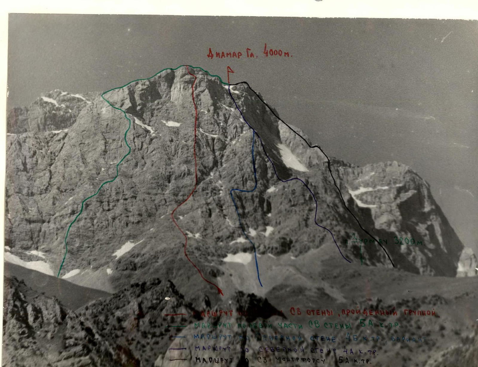
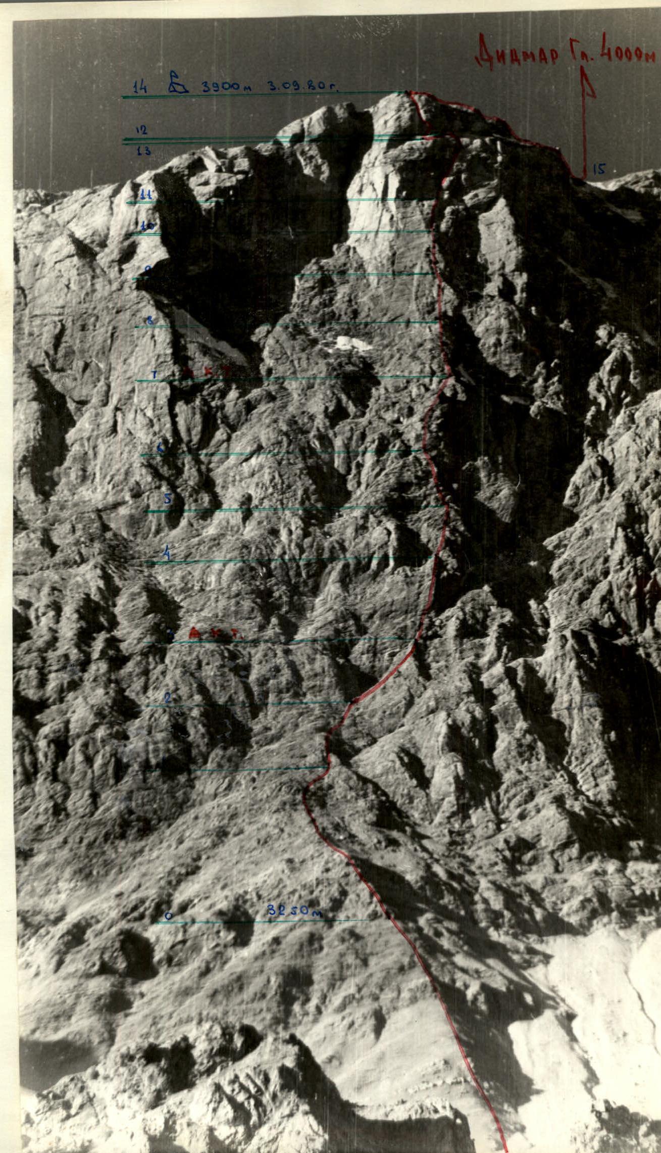
- Peak, its height, ascent route: p. DIAMAR GLAVNY (4000 m) via the center of the NE wall, 3rd ascent of the route.
- Proposed difficulty category: — 5B.
- Route characteristics: elevation gain — 750 m. length of sections with 5–6 difficulty category — 560 m. average steepness of the entire route — 65 degrees. average steepness of the wall section — 75 degrees.
- Pitons hammered in: rock pitons — 91. including for creating intermediate anchor points — 4. bolt pitons — 1. ice screws — 0.
- Number of climbing hours — 16.
- Number of overnight stays and their characteristics: one overnight stay — on the ridge, comfortable, safe.
- Full names of participants and their qualification: Babeshko V.P. — Candidate for Master of Sports, Valiulin Z.A. — Candidate for Master of Sports.
- Team coach: Mumdzhi T.M., Master of Sports of the USSR, instructor-methodologist 1st category.
- Date of departure and return: departure — September 3, 1980, return — September 4, 1980.
Route Profile
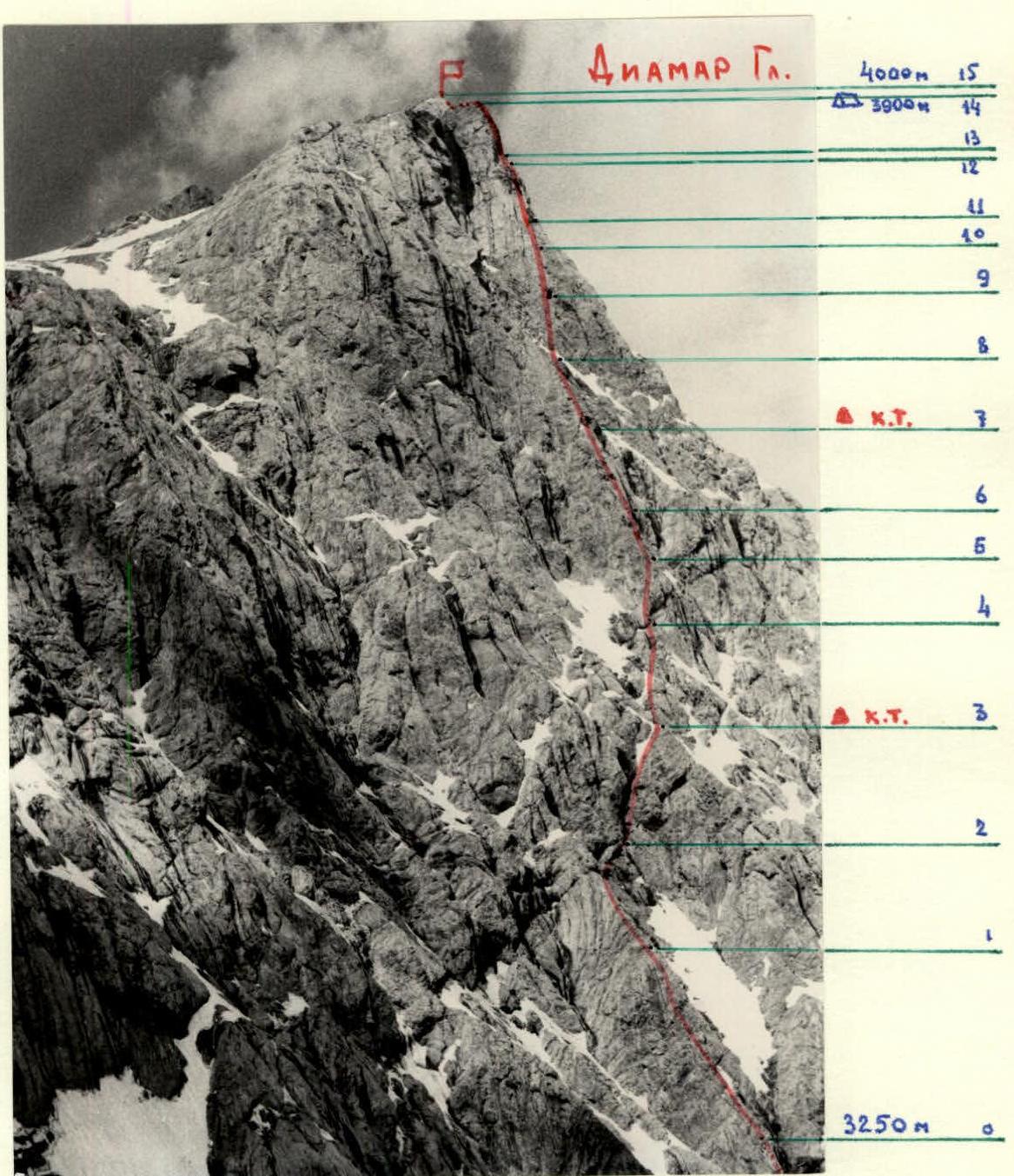
To p. Diamar Glavny via the center of the North-East Wall. From the Artuch alpine camp, go up the Zierat gorge to Chukurak Lake, 30 minutes. Then, move up to the right along a side gorge leading to Zurmech Pass.
The journey from Chukurak Lake to the base of Zurmech Pass takes 1.5–2 hours. There is a bivouac site here. Water and firewood are available.
From the bivouac, ascend initially along a large scree couloir, then along a moderately steep, crumbling rock ridge to the base of the central part of the northeast wall, 45 minutes.
A good landmark for the route is a large inner corner in the upper part of the wall with a sheer right face-“mirror,” clearly visible from below and from a distance. A vertical line drawn down through this corner leads directly to the start of the route.
Brief explanation of the table
Most of the route goes through the central rock bastion of the northeast wall.
Ascend along a crumbling ridge, then move right to a small rock wall with an inner corner. Climb up through the inner corner, then move right along crumbling rocks to exit into a large triangular depression at the base of a steep wall. Then, move up and to the right through a large inner corner, followed by a chimney to a small rock shelf (sections R0–R3). The 1st control point is located here.
Initially, climb up and to the right through the chimney, then vertically up a steep rock pillar. From its top, ascend a monolithic rock wall of triangular shape. Then, move left and up along crumbling rocks, followed by a rock ridge to a small horizontal scree shelf. On both sides are large rock couloirs-gullies. Climb up and to the right along a wall with varied terrain to a large snow-covered shelf-terrace (sections R3–R7). The 2nd control point is here.
Climb up a steep ridge to the base of a steep, crumbling wall broken by two vertical chimneys. Ascend the left chimney vertically, then follow a steep monolithic ridge, and subsequently an inner corner to the base of a large overhanging white wall. Climb up and to the right along the wall, then through an inner corner under a large yellow overhang. The overhang is traversed on the right via a crack, exiting onto a large rock shelf (sections R7–R12).
Move left along the shelf to a large vertical chimney that leads to the pre-summit ridge (sections R12–R14).
Follow a relatively easy, scree-covered ridge to reach the summit. Descend from the summit to Saryshakh Glacier and then follow a trail back to the Artuch alpine camp.
TABLE OF MAIN ROUTE CHARACTERISTICS
