Ascent Passport
I. Ascent class — rock.
- Ascent area — Zaravshan range, Fann Mountains.
- Peak — Gornoe Ekho, height — 4094 m. Ascent route — via the Eastern ridge, partially explored.
- Estimated difficulty category — 3A.
- Route characteristics: height difference — 600 m, sections of 5th and 6th difficulty categories are absent, average steepness — 40°. The route is combined.
- Pitons hammered: for belaying: rock — 5, ice — 2, chocks used — 5.
- Number of climbing hours — 6 hours.
- The route is completed without overnight stays.
- Leader: Belova V.P. — 2nd sports category
Team members:
- Smirnov A.S. — 2nd sports category
- Zimovets V.I. — 2nd sports category
- Nurieva A.G. — 2nd sports category
Team coach: Solovey O.M., Candidate Master of Sports, 2nd category instructor-methodologist.
II. Date of departure on the route — August 30, 1983.
Date of return — August 30, 1983.
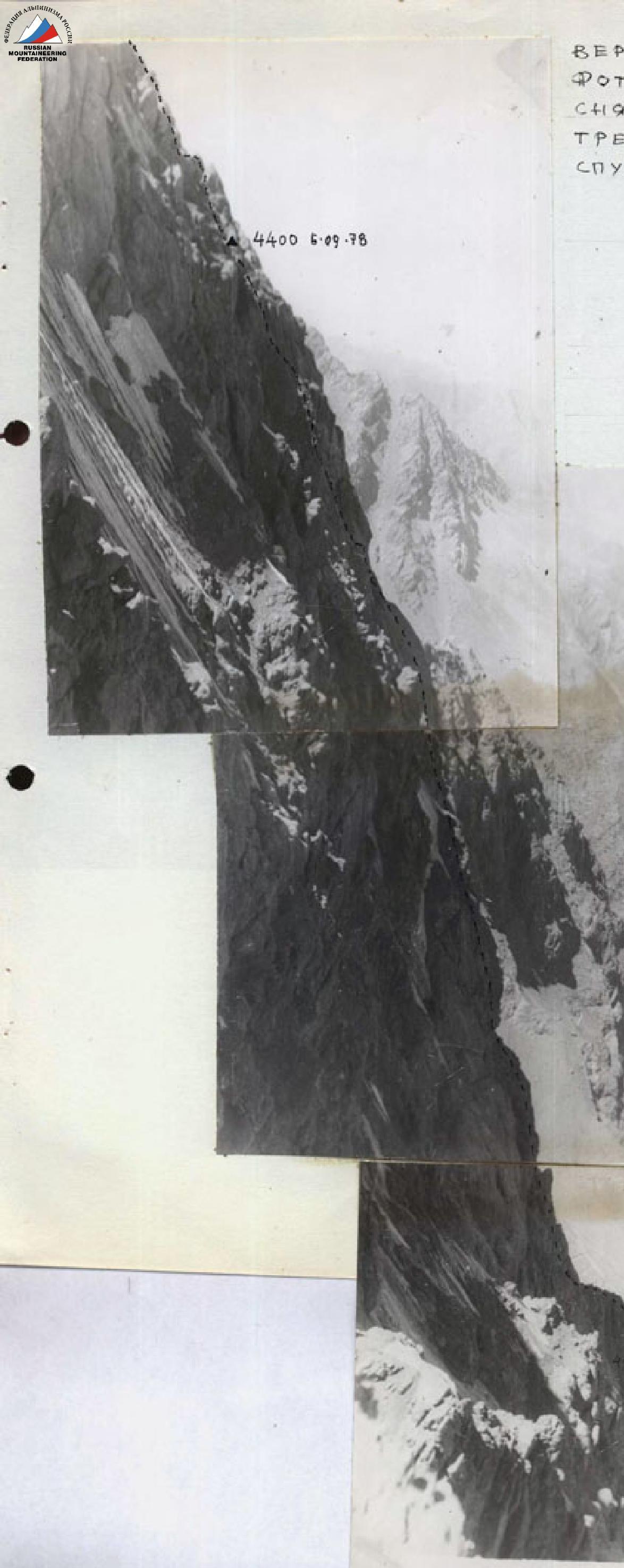 VERTICAL PHOTOPANORAMA TAKEN FROM THE EASTERN RIDGE ON THE DESCENT ROUTE.
 V. Popadya, 4094 m.

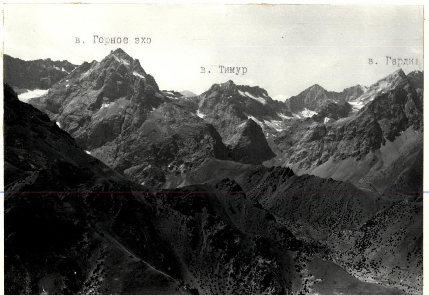
PHOTOPANORAMA OF THE ASCENT AREA (view from the north)
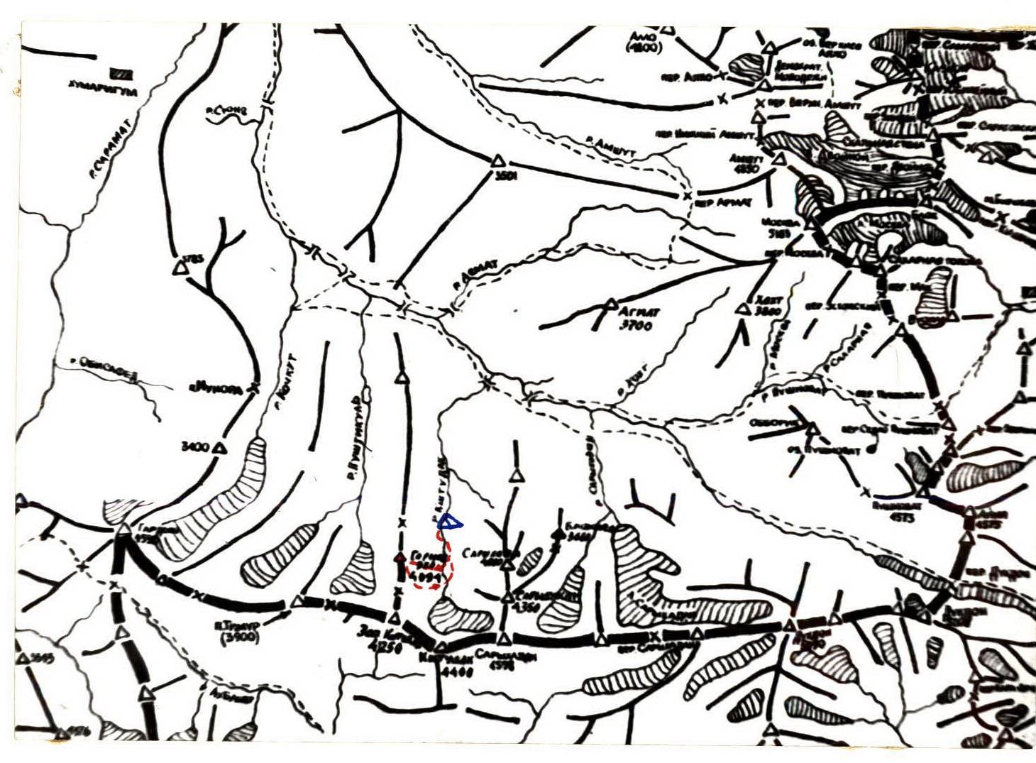
MAP OF THE ASCENT AREA.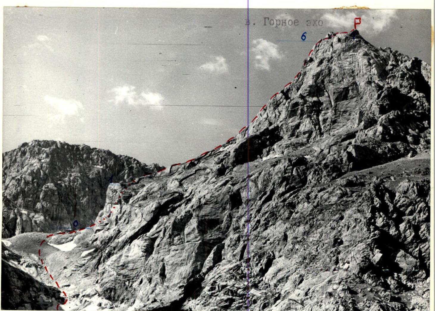 Route via the Eastern ridge 3A category, partially explored.
Scheme of the route to v. Gornoe Ekho via the E. ridge 3A category.
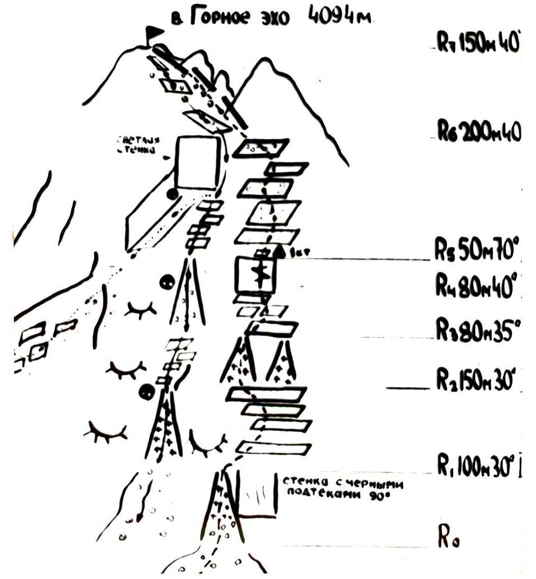 SCHEME OF THE ASCENT ROUTE in UIAA symbols.
Brief description of the approach and ascent route
Ascent
From the base camp on the Kishtudak River, up the scree through the "ram's foreheads" to the moraine of the Kishtudak glacier. Further along the large scree and snowfield, bypassing the beginning of the ridge, to a wide crevice (couloir) in the vertical wall with black streaks. From the base camp, about 2 hours.
Section R0–R1. Ascent through the couloir:
- initially along steep slabby blocks,
- then on ice and simple rocks.
Exit to a wide rock shelf.
Section R1–R2. Ascent from the shelf to the left along rough slabby rocks, arranged in layers, with easy scree in the direction of the tower on the ridge. Simultaneous movement. Exit to two parallel couloirs formed by narrow vertical ridges.
Section R2–R3. Ascent through the left couloir (can be done via the right one) on ice with exposed rocks to a wide shelf. Simultaneous movement.
Section R3–R4. From the shelf, traverse to the right, then to the left along a narrow oblique shelf-crack, ascent under the tower, on which two cracks are clearly visible, on a slab covered with ice, to a small site.
Section R4–R5. Ascent along the tower to a small shelf 8–10 m and exit through the right crack to the back side of the tower. Difficult climbing, rope protection! Exit to a narrow shelf and from it to the shoulder. Control point.
Section R5–R6. Exit along inclined scree rock shelves to the pre-summit ridge. Simultaneous movement.
Section R6–R7. Movement along the pre-summit ridge, then along rock shelves on the left side. Exit to the summit. Ascent time from the start of the route is 5.5–6 hours.
Descent along the ascent route to section R6 and turn right down along the rock scree shelves towards the "Timur" pass West Kishtudak or slightly to the left — into the gap in the ridge into the couloir, then:
- "rappel" 20 m,
- descent through the couloir,
- "rappel" 40 m to a snowfield,
- along the snowfield 40 m to scree,
- further down to the base camp.
Descent time is 2–2.5 hours.
Table of main characteristics of the ascent route
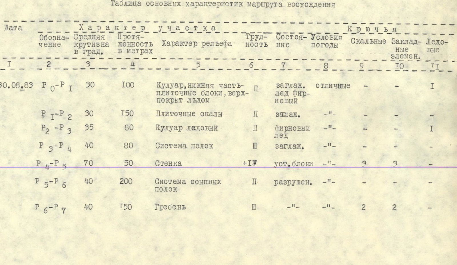
| Date | Designation | Average steepness, ° | Length, m | Terrain characteristics | Difficulty | Condition | Weather conditions | Rock pitons | Chocks | Ice pitons |
|---|---|---|---|---|---|---|---|---|---|---|
| 30.08.1983 | R0–R1 | 30 | 100 | Couloir, lower part – slabby blocks, upper part covered with ice | 1 | smooth | excellent | 1 | ||
| R1–R2 | 30 | 150 | Slabby rocks | 1 | smooth | – | ||||
| R2–R3 | 35 | 80 | Ice couloir | 1 | firm snow | – | 1 | |||
| R3–R4 | 40 | 80 | System of shelves | 3 | smooth | – | ||||
| R4–R5 | 70 | 50 | Wall | 4 | stable blocks | – | 3 | 3 | ||
| R5–R6 | 40 | 200 | System of scree shelves | 1 | broken | – | ||||
| R6–R7 | 40 | 150 | Ridge | 3 | – | – | 2 | 2 |