
Ascent Passport
- Ascent class — technical.
- Ascent area, ridge — Fann Mountains, Zarafshan Ridge.
- Peak, its height, ascent route: peak Gardish, 4590 m, via the northern wall, first ascent.
- Proposed difficulty category — 5B.
- Route characteristics: length of sections with 5–6 difficulty category — 1000 m, height difference — 1230 m, average steepness — 63°.
- Pitons driven: for belaying: rock — 171, ice — 5, climbing protection — 15. for creating I.T.O.: rock — 17, climbing protection — 2.
- Number of overnight stays and their characteristics — 3: 1st — on a moraine, comfortable, safe; 2nd — laid out on a rock shelf, comfortable, safe; 3rd — laid out on a rock shelf, safe, slept semi-reclined.
- Number of walking hours — 36 hours.
- Surname, name, patronymic of the leader, participants, and their qualifications: Mumdzhi Timur Memetovich — Candidate Master of Sports, leader; Golubev Nikolai Nikolaevich — Candidate Master of Sports; Dzhbraev Yuri Georgievich — Candidate Master of Sports; Andreev Leonid Aleksandrovich — Candidate Master of Sports; Parkhomenko Alexander Leonidovich — Candidate Master of Sports; Dronov Yuri Vladimirovich — 1st sports category.
- Team coach — Shumilov Oleg Ivanovich.
- Date of departure to the route and return: departure to the route — September 3, 1978; return — September 6, 1978.
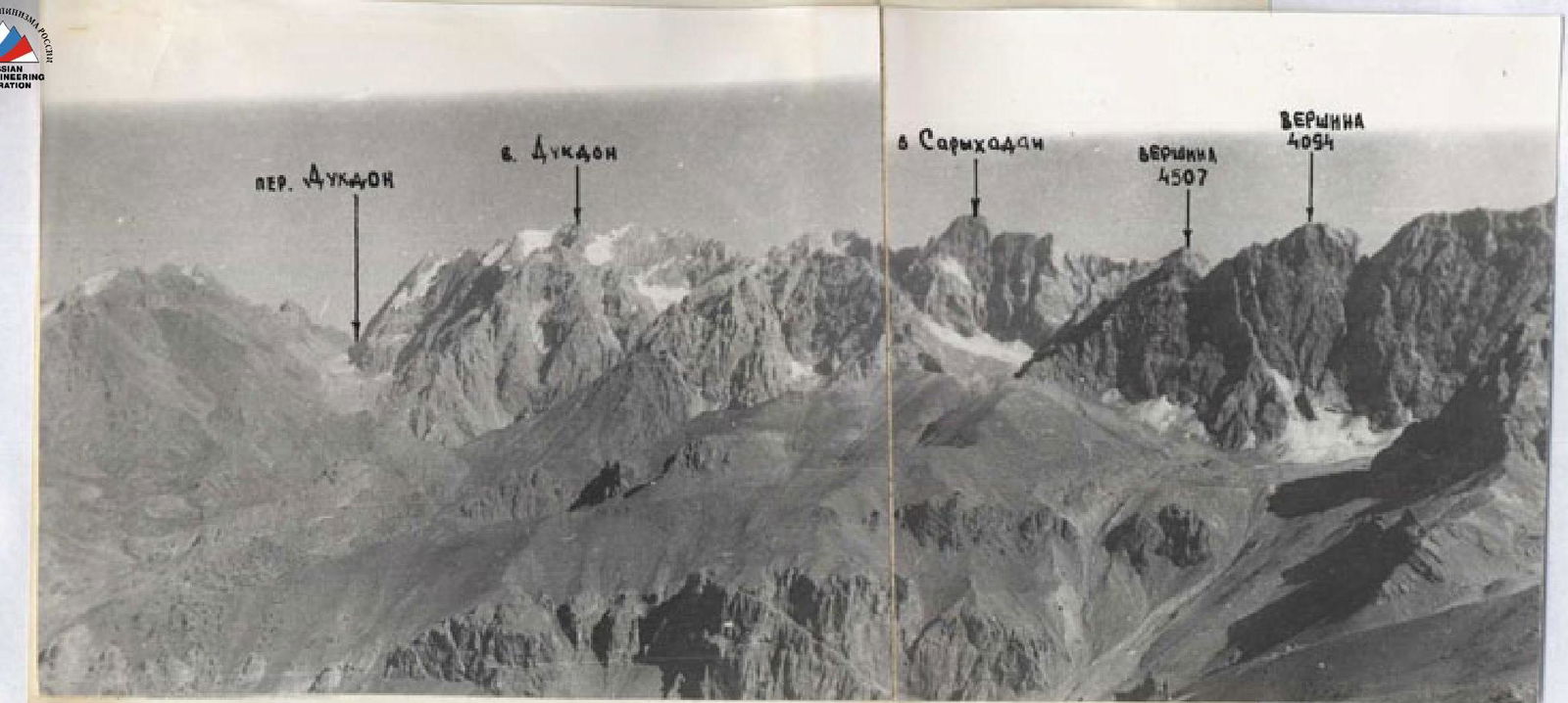
Panorama of the ridge from Dukdr pass to Gardish peak
The Gardish massif from the north. Taken from a helicopter on September 5, 1978.
| Section | Height, m |
|---|---|
| R26 | 4590 |
| R25 | |
| R24 | |
| R23 | |
| R22 | 4400 |
| R21 | |
| R20 | |
| R19 | |
| R18 | |
| R17 | |
| R16 | |
| R15 | |
| R14 | |
| R13 | |
| R12 | |
| R11 | |
| R10 | |
| R9 | 3850 |
| R8 | |
| R7 | |
| R6 | 3660 |
| R5 | |
| R4 | |
| R3 | |
| R2 | |
| R1 | |
| R0 | 3370 |
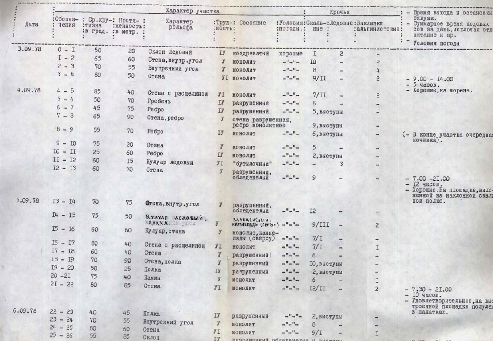
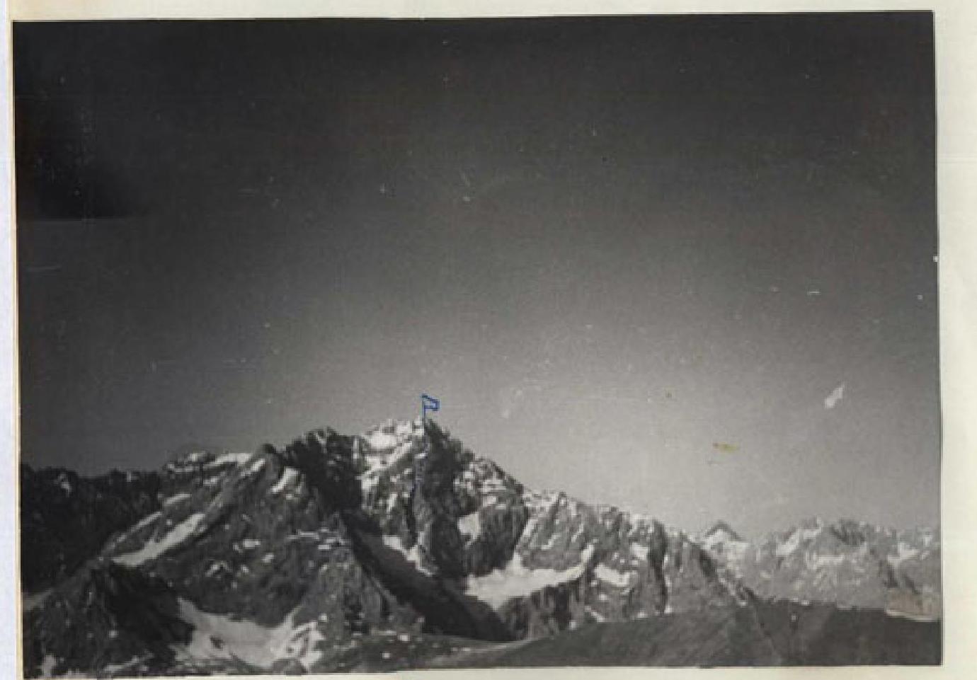
Photo taken from the north.
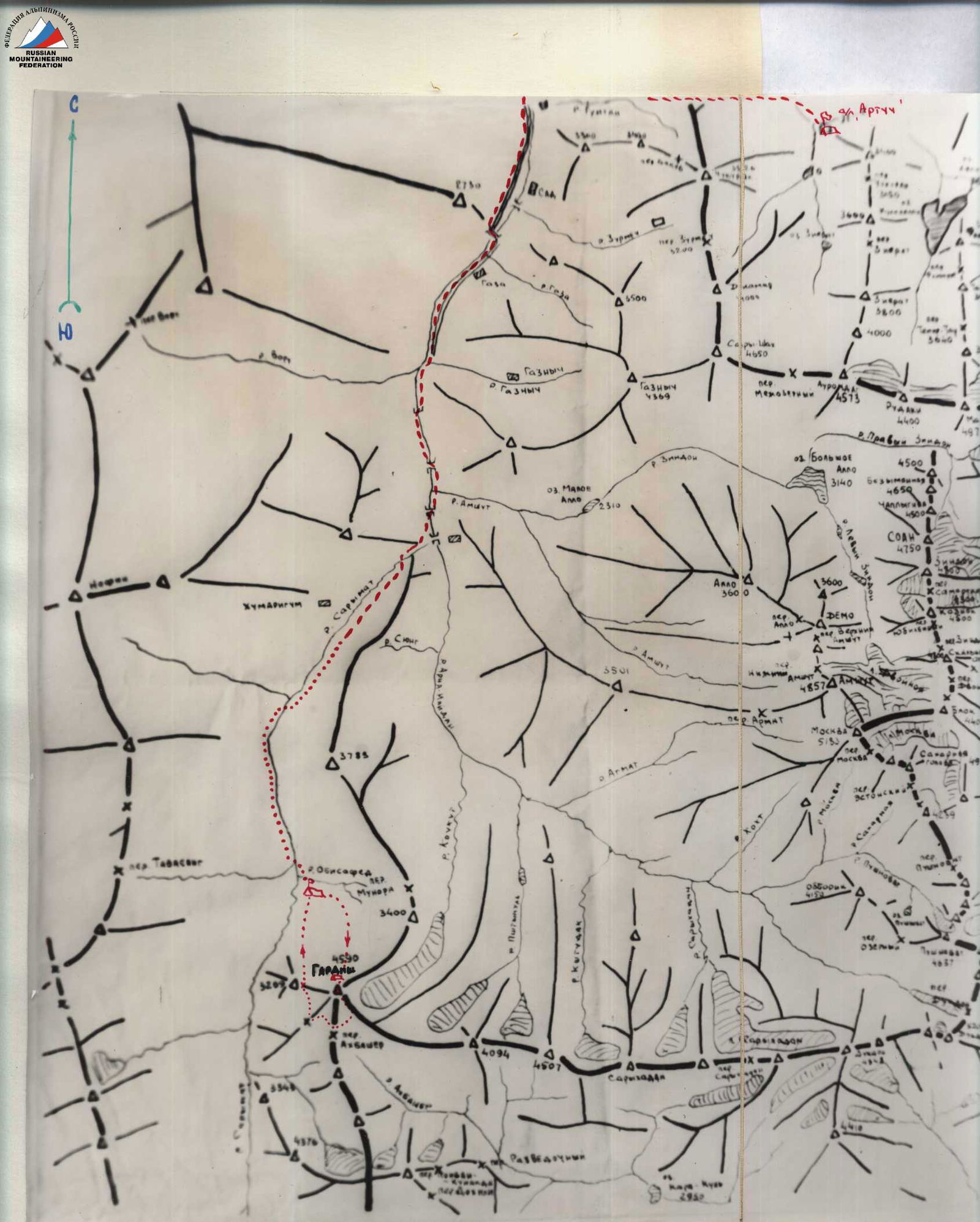
AREA MAP-SCHEME
Table of main route characteristics
| Date | Designation | Avg. steepness, ° | Length, m | Terrain character | Difficulty | Terrain condition | Weather conditions | Rock | Ice | Climbing protection | Time of departure and stop for bivouac | Total time of walking hours per day, excluding rest, food, etc. | Weather conditions |
|---|---|---|---|---|---|---|---|---|---|---|---|---|---|
| September 3, 1978 | R0–R1 | 50 | 20 | Ice slope | 4 | porous | good | 1 | 2 | – | |||
| R1–R2 | 65 | 60 | Wall, internal angle | 5 | monolith | – | 10 | – | 2 | ||||
| R2–R3 | 70 | 55 | Internal angle | 5 | monolith | – | 8 | – | 4 | ||||
| R3–R4 | 80 | 50 | Wall | 6 | monolith | – | 9/11 | – | 2 | from 9:00 to 14:00 | 5 hours | Good, on moraine. | |
| September 4, 1978 | R4–R5 | 85 | 40 | Wall with crack | 6 | monolith | – | 7/11 | – | 2 | |||
| R5–R6 | 50 | 70 | Ridge | 4 | destroyed | – | 6 | – | – | ||||
| R6–R7 | 45 | 75 | Edge | 4 | destroyed | – | 5, ledges | – | – | ||||
| R7–R8 | 65 | 90 | Wall, edge | 5 | wall destroyed, edge monolithic | – | 9, ledges | – | – | ||||
| R8–R9 | 55 | 70 | Edge | 4 | monolith | – | 6, ledges | – | – | (At the end of the section, another overnight stay). | |||
| R9–R10 | 75 | 20 | Wall | 5 | monolith | – | 5 | – | – | ||||
| R10–R11 | 25 | 60 | Edge | 4 | monolith | – | 2, ledges | – | – | ||||
| R11–R12 | 60 | 15 | Ice couloir | 6 | "bottled" | – | 3 | – | – | ||||
| R12–R13 | 60 | 70 | Wall | 5 | destroyed, iced | – | 9 | – | – | from 7:00 to 21:00 | 12 hours | Good. On a site laid out on an inclined rock shelf. | |
| September 5, 1978 | R13–R14 | 70 | 75 | Wall, internal angle | 5 | destroyed, iced | – | 12 | – | – | |||
| R14–R15 | 75 | 50 | Ice couloir, shelf | 5 | iced. Rockfall (from above) | – | 9/111 | – | 2 | ||||
| R15–R16 | 60 | 60 | Couloir, wall | 5 | monolith, rockfall (from above) | – | 7/1 | – | – | ||||
| R16–R17 | 80 | 40 | Wall with crack | 6 | monolith | – | 7/1 | – | 1 | ||||
| R17–R18 | 60 | 40 | Wall | 5 | destroyed | – | 6 | – | – | ||||
| R18–R19 | 70 | 90 | Wall, shelf | 5 | destroyed | – | 10, ledges | – | – | ||||
| R19–R20 | 50 | 25 | Shelf | 4 | destroyed | – | 2, ledges | – | – | ||||
| R20–R21 | 75 | 40 | Chimney | 5 | monolith | – | 6 | – | – | ||||
| R21–R22 | 80 | 85 | Wall | 6 | monolith | – | 12/11 | – | 2 | from 7:30 to 21:00 | 13 hours | Satisfactory, on a constructed site, semi-reclined in tents. | |
| September 6, 1978 | R22–R23 | 40 | 45 | Shelf | 4 | destroyed | – | 2, ledges | – | – | |||
| R23–R24 | 70 | 55 | Internal angle | 5 | monolith | – | 8 | – | – | ||||
| R24–R25 | 80 | 60 | Wall | 6 | monolith | – | 9/1 | – | 1 | ||||
| R25–R26 | 55 | 85 | Slope | 4 | destroyed, iced | – | 4, ledges | – | – | from 8:00 to 14:00 | 6 hours | Ascent to the summit. |
Brief explanation
To the table of main route characteristics
The Gardish peak as an object of ascent was chosen by us in previous years. It looks good from the peaks of the West Fann Ridge. At that time, the ascent route was preliminarily planned along the center of the northern wall. The route is so logical and unambiguous that clarifying it through direct observation and study of the northern wall did not significantly change the initially chosen option for passing it.
September 3 From the bivouac on the Gardish glacier moraine along the glacier to the bergschrund at the base of the large rock triangle, which divides the upper hanging glacier of the northern slopes of the Gardish massif in two, — 30 minutes. Section R0–R1:
- Through the bergschrund;
- overcoming a steep ice wall 2 m;
- further along the ice slope to the left part of the rock triangle. Section R1–R2: Along steep plate-like rocks, then along a large stepped internal angle turning into a chimney, under a small rock overhang at the base of a steep vertical crevice. Section R2–R3:
- Up the crevice;
- then along a highly dissected sheer wall to a large inclined rock terrace;
- along it to the base of a monolithic sheer wall. Section R3–R4: Along the wall vertically upwards to a rock block-overlay of oval shape. Holds are small. Climbing is very difficult using ladders. We descend down on the suspended ropes to the bivouac on the moraine.
September 4 We ascend along the fixed ropes to the end of section R3–R4. Section R4–R5:
- Bypassing the rock block on the right along a shelf, we exit to a large sheer internal angle;
- up the vertical chimney of its right face;
- two rock plugs are overcome using artificial points of support;
- climbing is very difficult, mostly on friction;
- exit to a rock shelf. Section R5–R6: Further along a wide, highly dissected rock ridge to the top of the large rock triangle. Section R6–R7: Along the destroyed rock edge of light gray color, further along the highly destroyed rocks of the edge of dark red color in the direction to the base of the large ice couloir. The end of the section is prone to rockfall (stones fall along the couloir), as individual stones may fall ricocheting off the left side of the steep ice couloir. Section R7–R8: Up to the left along the destroyed rock wall of red color to a steep narrow edge of light gray color, limiting on the right (orographically) the steep ice couloir. Section R8–R9: Again up along the monolithic sharp edge to an almost horizontal rock shelf near the junction of two ice couloirs. On the Section, we organize a bivouac, as safe overnight stays are not expected soon. We lay out a site for two tents. A control cairn is also set up here. In the remaining daylight, we process the further path. Section R9–R10: Along the sheer monolithic wall of the edge upwards to its flattening part. Section R10–R11: Along a non-steep but sharp edge to the junction of two steep ice couloirs. Section R11–R12: We cross the left ice couloir (almost along the line of junction of two couloirs) from right to left upwards. Very steep. Ice is hard ("bottled"), greenish in color. Section R12–R13: Along smoothed rocks to the left upwards. Further along an internal angle, iced and turning into a narrow steep ice groove. The groove leads to a large inclined rock shelf sprinkled with scree of rocky material. Leaving the suspended ropes, we descend down for an overnight stay.
September 5 We pass along the fixed ropes the section processed the previous day. Section R13–R14:
- A bit to the right along the shelf;
- then up a steep vertical chimney. The chimney leads to a sheer wall;
- along a narrow crevice up the wall under a large rock overhang of red color. Section R14–R15:
- Along a narrow shelf to the right under the overhang to the "neck" of the large ice couloir (the couloir is maximally narrowed here);
- along the ice and rock outcrops to an inclined not wide shelf at the base of the rock massif dividing the upper part of the large ice couloir in two;
- to the right along the shelf, then up to an oblique vertical crevice-chimney. Section R15–R16: First along the crevice-chimney, further along dissected rocks and along the couloir to an oblique overturned wide crevice. (Rockfall is possible on the section from above.) Section R16–R17: From the oblique crevice to the left upwards along the sheer wall. Climbing is very difficult, holds are small. Ladders are used for passage. Section R17–R18: Further to the right upwards along an oblique crevice in the wall to the base of a steep vertical chimney. Section R18–R19:
- From the chimney to the right upwards along a narrow shelf;
- then vertically upwards along the red wall under an overhang. Section R19–R20:
- From under the overhang to the right upwards along a scree inclined shelf;
- to a steep monolithic rock ascent. Section R20–R21:
- Upwards along steep rocks of the large internal angle;
- then along a vertical white chimney;
- to a large sheer wall block of light gray rocks. Section R21–R22: Along the steep monolithic wall vertically upwards. The wall is smooth, holds are small. Climbing is on friction, ladders are used. In the middle part of the wall, there is a horizontal ledge from which a steep crevice with ice goes upwards. Along it up to a scree inclined shelf. On the shelf, we organize a bivouac — a small site where two tents can hardly fit.
September 6 Section R22–R23:
- Along the scree iced shelf to the right upwards;
- to a rock split in the wall. Section R23–R24:
- To the left upwards along a destroyed internal angle;
- then along an iced couloir;
- to a sheer gray wall. Section R24–R25:
- Upwards along the wall through a large destroyed rock lens ("overlay"). Difficult, dangerous;
- the ropes are thrown to the left from the "overlay" to the smooth sheer of the wall;
- exit to a large scree shoulder. Section R25–R26:
- Along the destroyed rock slope, iced and stuck together with flow ice;
- exit to the summit.
Descent from the summit along the ridge to the east to a saddle composed of monolithic inclined gray slabs. Further to the south, first along a scree slope, then along slabs (40 m of sport descent) and along a steep monolithic step-like wall to the left of a steep couloir filled with ice (3 × 40 m descent "Dulfer") to the upper reaches of the Karakul gorge. Through the Akhbasher pass to the Sarymat gorge. The descent from the summit and the passage through the Akhbasher pass to the confluence of the Sarymat and Obisafed rivers took 6 hours.
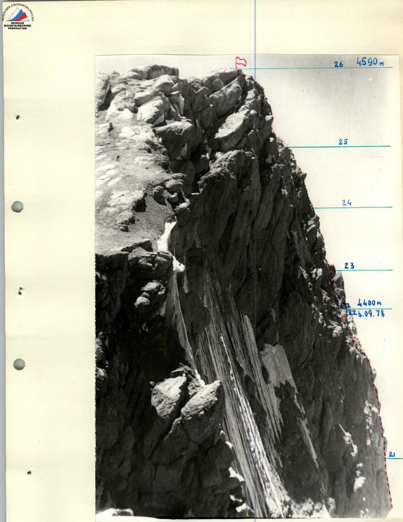
Photo of the profile of the upper part of the route. Taken from the SE ridge of peak Gardish
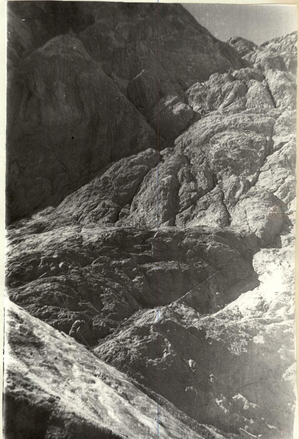
Section R1–R2
View from north-northwest.

Profile and height marks on the route
View of the route from NW, from below from the approaches. The sign Φ shows the location on the E ridge of the vertical panorama shooting of the profile — see next page.
Comments
Sign in to leave a comment