INTERNATIONAL ALPINISM AND TOURIST CENTER "VERTIKAL-ALAUDIN" www.fany.ru↗
Peak Bodhona East, via the North Face (B. Bogdanov's route, 1991)
Ascent Passport
Technical Grade. Pamir-Alay, Fann Mountains. Peak Bodhona East, via the North Face (B. Bogdanov's route, 1991) Difficulty category — 6B, first ascent.
Ascent characteristics:
- Elevation gain — 1770 m, wall section — 1650 m
- Length — 2866 m, wall section — 1976 m
- Length of sections with 5-6 difficulty grade — 701 m (6th grade — 375 m)
- Average steepness of the main route — 60°, section R0–R28 — 65°, section R34–R53 — 70°
- Pitons used: rock 41/10, chocks 124/20, bolted 3/0, ice 32/0
- Total climbing hours — 67.5 hours
- Number of days — 7
Nights:
- 1st-6th — lying on platforms made of snow
MSU Team, R.V. Khokhlov Alpine Club. Team coach — Rufina G. Arefieva.
Team members:
- Leader: Boris B. Bogdanov, Master of Sports
- Participants: Sergei V. Antonov, Candidate for Master of Sports
- Alexei S. Boldyrev, Candidate for Master of Sports
- Sergei L. Menshenin, Candidate for Master of Sports
- Boris N. Burykin, Candidate for Master of Sports
Departure to the route: July 17, 1991 Summit: July 22, 1991 Return: July 23, 1991
Sverdlovsk Region, 1991
2005–2006 MATC "Vertikal-Alaudin" Copyright
Brief Overview of the Climbing Area
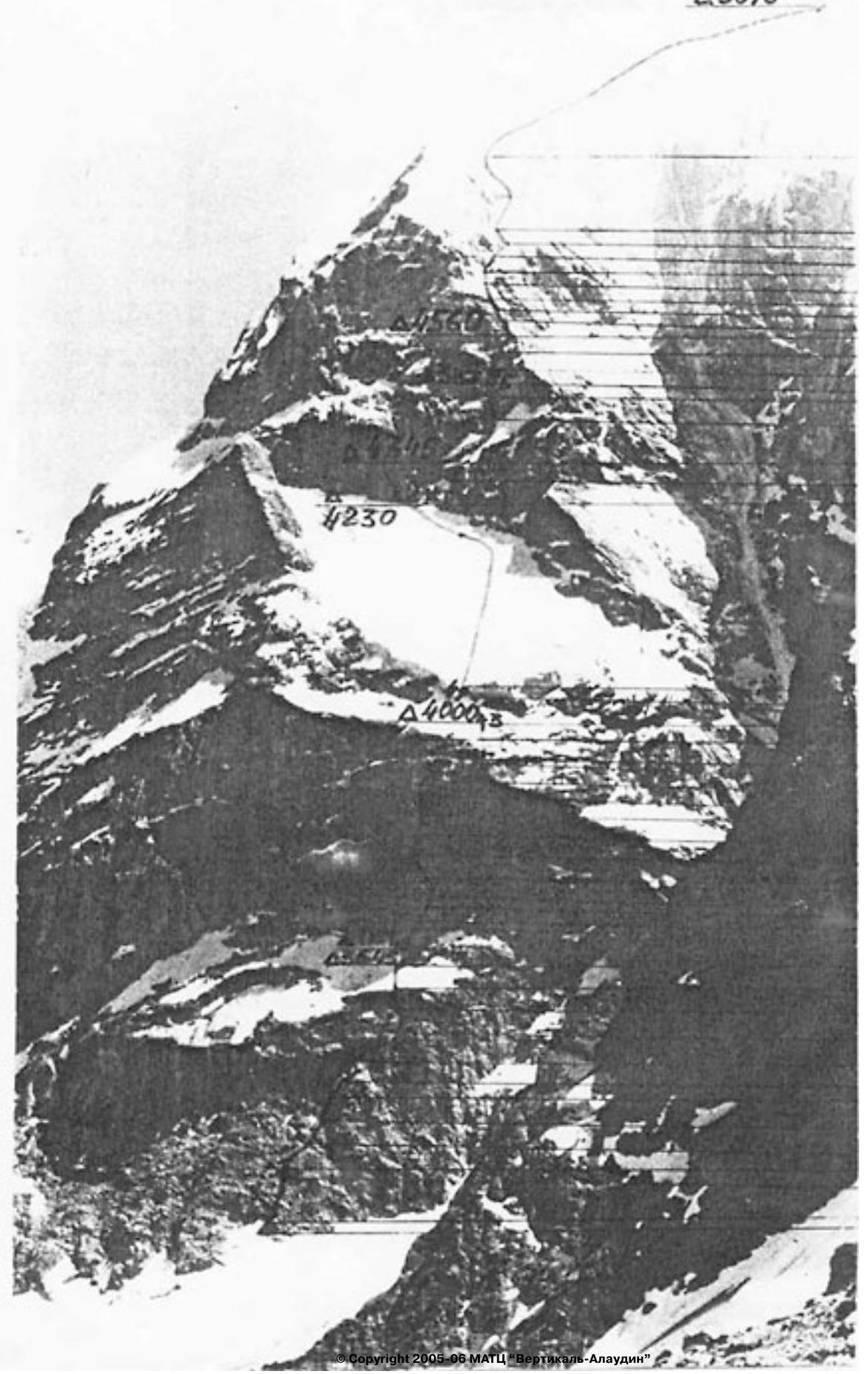
Peak Bodhona East is located in the well-known area of Alaudin lakes in the Fann Mountains. It is situated north of the Chapdara peak. The approach from the base camp on the lakes through the Talbas pass takes 3-4 hours. Nights under the route are spent on the median moraine of the glacier.
Preparation for the Ascent
The team had visited the Alaudin lakes area in 1987 and 1988. During that time, the North Face of Bodhona East was considered as a potential object for a first ascent. In 1990, the face was thoroughly examined by the team's coach. After this, it was decided to register this face for the Moscow City Championship.
Preparation for the championship included two components: 1) physical and technical training and 2) equipment preparation. Joint training sessions were conducted on the Sparrow Hills, in Krylatskoe, and on a climbing wall at MSTU. A gathering was held in Crimea. By the championship, a set of equipment meeting all modern requirements was prepared. In the Fann Mountains, acclimatization and training ascents (up to 5B category) were made. The entire team passed physical standards with excellent marks. Thus, the team was fully prepared for the ascent. Given the highly unstable weather that season, it was decided to start the ascent regardless of the weather.
Tactical Actions of the Team
The team approached the route on July 15, 1991, in the afternoon. The remainder of the day was spent observing the face and finalizing the route plan.
On July 16, 1991, the Boldyrev-Antonov rope began processing the route. They processed 5 ropes. Meanwhile, other team members observed the route, primarily the serac zone. In the lower part of the route, icefalls were not dangerous. As they approached the glacier, the danger increased, but the route was laid out such that all icefalls passed to the side.
On July 17, 1991, the team departed in full strength. The Menshenin-Boldyrev rope led. They quickly reached the intended overnight spot — a large snow ledge. They began further processing but were halted by rain. The rocks became very wet and difficult to climb. Only 3 ropes were processed (instead of 4), and it was decided to set up camp. On a narrow ledge under a slight overhang, they flattened a spot for the tent. The overnight stay was comfortable and lying down. They managed to dry out a bit. Rain continued for the rest of the day and half the night.
On July 18, 1991, the weather was good in the morning. They quickly passed the fixed ropes. The Boldyrev-Bogdanov rope led. The most challenging section of the lower wall began:
- steep,
- water flowed in places,
- climbing was extremely difficult, but they hadn't yet used any artificial aids.
By 16:00, the most challenging ropes were passed, but the wall was almost completely flooded with water. This made movement even on relatively simple sections very difficult. Due to this, they couldn't directly approach the serac zone and had to traverse 2 ropes to the right under waterfalls. Then, via simple rocks, they reached a snow slope leading to the serac zone. It was about to get dark, so they decided not to process the ice wall further and instead set up camp. On a small snow ridge, a spot for the tent was dug out for a lying down overnight stay.
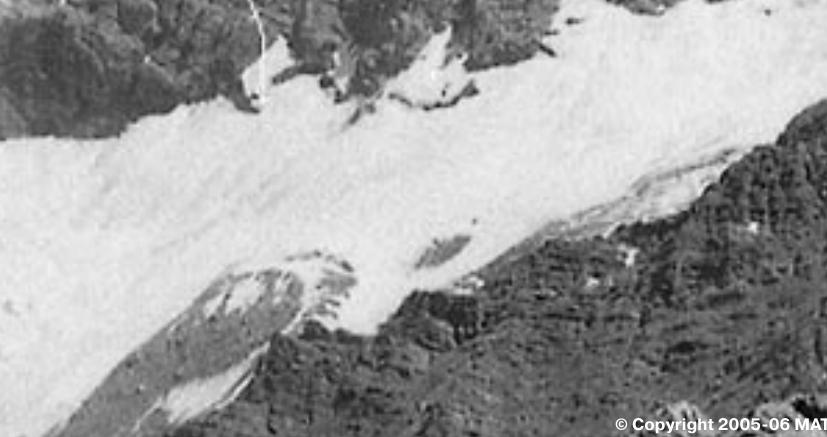
On July 19, 1991, they passed the ice wall. Menshenin-Burykin worked on it. The wall:
- overhung (photo 4),
- was covered with a crust of rotten ice.
This significantly complicated and slowed down the passage. Nevertheless, the wall was passed, and the team moved quickly up towards the glacier. The glacier wasn't very steep, but the ice was covered with a thin layer of snow. Crampons got stuck, and utmost attention was required to avoid slipping. They had to rotate ice axes and move alternately. They reached the bergschrund and followed it to the left (only there could they organize reliable protection). Eventually, they exited into a recess under an overhanging wall. Here, they decided to set up camp. The spot was comfortable, with a lying down overnight stay. They reached the campsite by 17:00. At that time, the snow had become very slushy and didn't hold. Under these conditions, they decided not to process further (rocks buried in snow) and to pass this section in the morning when it was colder, wearing crampons.
On July 20, 1991, as planned, they fairly quickly passed two ropes and emerged under the "black wall." It represented tiles that faced downwards and crumbled under hands. Organizing reliable protection was practically impossible. Boldyrev passed this section via free climbing from left to right. Further, along a snow-ice slope (a thin layer of snow on ice), they approached the upper part of the wall. It was cold. The rocks were covered in ice. Climbing and organizing protection were very challenging. Boldyrev climbed half a rope, and a strong storm began:
- thunderstorm,
- snow pellets in bursts,
- streams of snow flowed down the wall.
Under these conditions, Boldyrev climbed another half rope to a more or less suitable belay point and descended. They descended another two ropes and set up camp. They chopped out a snow ridge and shaped a platform for the tent. All this was done in stormy weather. Snow fell until dark.
On July 21, 1991, they departed early in the morning. After yesterday's bad weather, the wall was icy, and all holds were covered with snow. They quickly passed the fixed ropes and warmed up a bit. Further, due to the state of the route, they began almost purely artificial climbing. Menshenin-Burykin led. An internal corner after two ropes turned into "negative rubble." Difficult free climbing followed. Then, via a small ice couloir and slope, they exited onto the right edge of the wall. They passed the "negative rubble" and ice in stormy conditions — again snow pellets. Therefore, they processed only half a rope and set up camp. Again, they shaped a platform and had a lying down overnight stay.
On July 22, 1991, they departed at 7:00. It was cold. There was ice and snow on the rocks. Boldyrev-Burykin led. Sections of snow alternated with sections of ice. Therefore, Boldyrev walked in galoshes, and Burykin in crampons, and they had to constantly switch leads, which significantly slowed down their movement. By 13:00, they passed the edge and moved right onto a snow-ice slope. The slope was quite long (5 ropes) and required alternating movement. At 15:00, bad weather began: snow pellets and strong wind. By 16:00, they reached the pre-summit ridge. The bad weather intensified. The ridge:
- was gentle,
- but very long,
- had cornices on one side,
- dropped steeply towards Chapdara on the other,
- deep snow alternated with ice under a thin layer of snow, complicating movement.
The bad weather ended at 19:00, but the wind was still strong. It got dark. Only at 20:45 did they reach the summit. 30 meters from the summit, they set up camp. They expanded the platform and had a lying down overnight stay. It was very cold.
On July 23, 1991, at 8:00, they began descending towards Peak Bodhona Main. By 12:00, they completed the descent onto the glacier under the Zamok peak. At 16:00, they were back at the camp on Alaudin lakes.
General conclusions:
- The team worked cohesively and confidently, and if not for the weather, there would have been no deviations from the tactical plan.
- The physical and technical preparation of the participants corresponded to the route taken, with a significant reserve of capabilities felt.
- The team used the entire arsenal of modern technical means on the route: UIAA ropes, "friends," "skyhooks," hook-nuts, and curved chocks.
- Communication with the base camp, where the rescue team was located, and with observers under the route was stable and regular.
- The route turned out to be technically and physically challenging, combined, requiring the application of the highest mountaineering techniques.
- In our opinion, it is no easier than the 6B route on Chapdara via Solonnikov.
Description of the Route by Sections
Section R0–R1. The route begins to the right of Kudinov's route, from a snow patch that rises highest on the wall. The bergschrund is overcome via a snow bridge. Then, from left to right, there's a series of small walls and ledges leading to the top of a slab.
Section R1–R2. An internal corner turning into a wall. Further, via a crack, there's an exit onto rocks resembling sheep's foreheads.
Section R2–R5. A wall leads under a cornice, which is bypassed on the right via a smooth slab.
Section R5–R8. Via an internal corner, there's an exit into an inclined chimney, and through it — onto sheep's foreheads.
Section R8–R10. An internal corner turning into a crack leads again onto sheep's foreheads.
Section R10–R11. Via a slab with a crack, there's an exit onto a large snow ledge.
Section R11–R12. Via snow, bypassing a recess — an approach under the rocks. In the recess, there's a convenient spot for an overnight stay.
Section R12–R15. Via an internal corner and slab — an approach under an overhang. To the right, along a ledge under the overhang — a difficult traverse.
Section R15–R18. A small section of sheep's foreheads leads under an overhang with a crack. The overhang is passed using artificial aids. Further, there's a series of small walls leading onto a wide inclined ledge.
Section R18–R19. Along the ledge, a traverse to the left towards an internal corner, through it — to the next ledge, and along it, a traverse to the left to the end.
Section R19–R21. From the ledge, via a wet wall (live rocks!) — into a wet internal corner, and through it — to a small ledge.
Section R21–R23. From the ledge, via an internal corner — bypassing a cornice on the left. Further, a vertical internal corner leads onto a narrow ledge under a slab.
Section R23–R25. From the ledge, via the right side of the slab, there's an exit onto its top. From here, via vertical slabs with few holds — under a cornice. Under the cornice — a difficult traverse to the right onto a small (for one person) ledge.
Section R25–R29. From the ledge, via wet steep slabs, bypassing an overhang on the right — an exit onto a wide wet ledge. Above the ledge — an overhang, through which water flows continuously. A traverse to the right through two waterfalls — 2 ropes.
Section R29–R32. Via slabs covered with live rocks, snow, and ice — an exit onto a snow slope, which leads under the ice wall (edge of the glacier). On the slope, an overnight stay is possible.
Section R32–R33. A 25-meter ice wall overhangs, covered with a crust of rotten ice. Ice screws hold poorly.
Section R33–R34. Glacier. A thin layer of snow on the ice. Movement directly upwards — towards the bergschrund. Under the cover of the bergschrund — to the left under an overhanging wall. In the recess, there's a convenient spot for an overnight stay.
Section R34–R35. From the right part of the recess, via rocks covered with snow and ice — an exit under the black wall.
Section R35–R36. The black wall consists of tiles that crumble under hands. Reliable protection is impossible. Along the wall to the right — onto a snow ridge. Here, an overnight stay is possible.
Section R36–R37. A snow-ice slope leads to the upper part of the wall.
Section R37–R39. An internal corner leads under an overhang, which is passed directly. Further, via snow-covered slabs — under the base of an internal corner.
Section R39–R42. A frozen internal corner (artificial aids) ends with an overhang. Through the overhang — onto slabs.
Section R42–R44. "Negative rubble." Vertical snow-covered slabs with live rocks. It's challenging to organize protection.
Section R44–R47. A traverse to the right under the base of an ice internal corner, up through it, and further along a snow slope to the right — onto the edge of the wall. Here, there's a convenient ledge for an overnight stay.
Section R47–R51. First, via icy slabs, then through an icy internal corner turning into a chimney, further via snow-covered slabs — an exit into a snow-ice couloir.
Section R51–R52. Via the couloir — into an ice internal corner.