I. Climbing category — technically challenging. 2. Climbing area — Fan Mountains. 3. Route — peak S. Bodhona (5300) via N. wall, 5B category of difficulty (Kudinov I.B. route, 1968) — 2nd ascent. 4. Climbing characteristics:
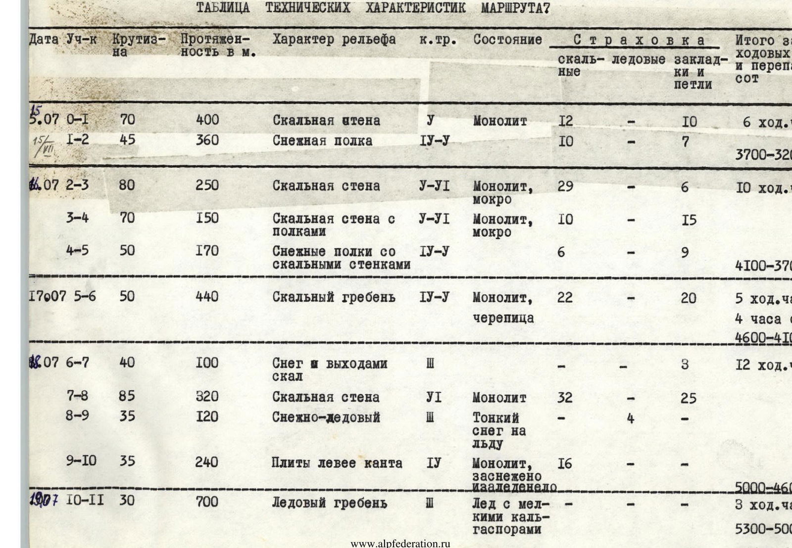
route length — 3270 m, height difference — 2100 m, average steepness — 75°, length of complex sections — 520 m — VI category of difficulty.
- Pitons used:
rock (including chocks) — 292, ice — 4
-
Total climbing hours — 40 h
-
Number of nights — 4 (all comfortable)
-
Number of climbing days — 5
-
Team of LGS DSO "Spartak"
-
Team coach — Kolchin A.A., MSМК.
-
Team members:
Razumov Yuri Mikhailovich — team leader, CMS
- Kolchin Alexander Alexandrovich — MSМК
- Isachenko Gennadiy Ivanovich — CMS
- Silin Boris Mikhailovich — CMS
- Climbing dates — July 15, 1979 – July 19, 1979
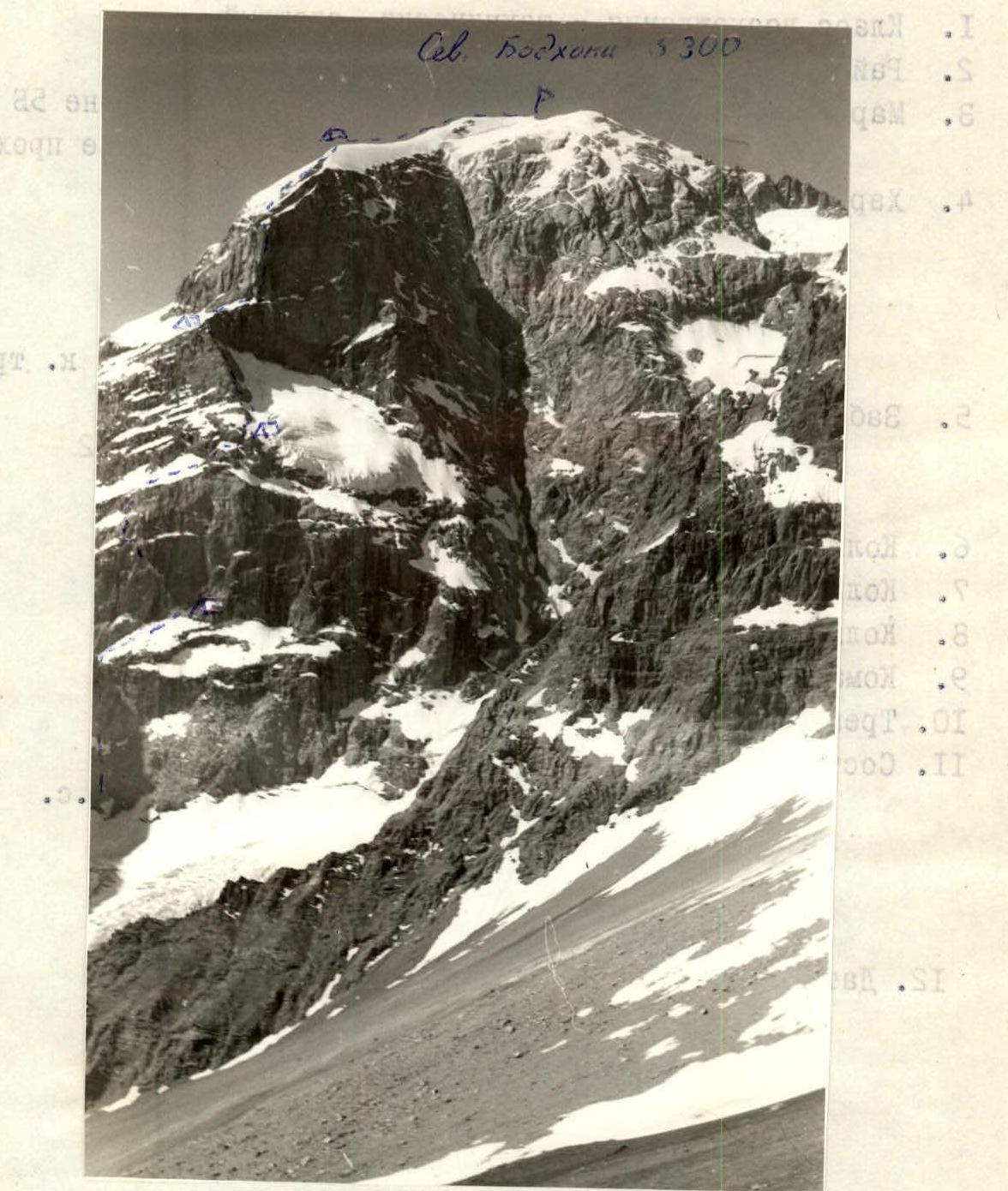
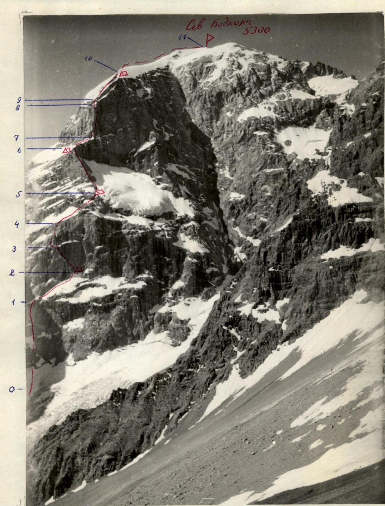
Route to peak Sev. Bodhona via N. wall.
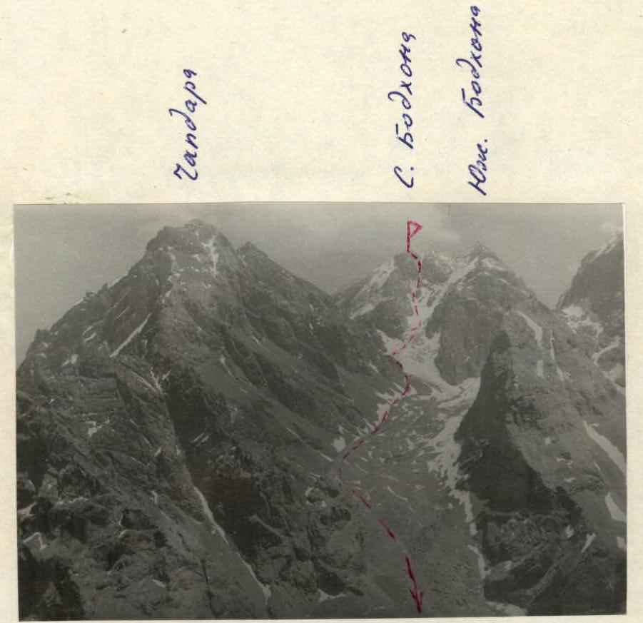
General view of Bodhona massif from the west. All peaks of the massif and the descent route from the N. peak are visible.
Description
of the route to peak Sev. Bodhona via N. wall (Kudinov's route, 1970). The N. wall of peak Sev. Bodhona is bisected by a giant couloir. To the left of the couloir, in the center of the wall, there is a hanging glacier. To the left of the glacier, at its level, there is a ridge that drops down to the glacier with a wall divided by a large snow shelf into two ascents. The route goes:
- along this wall,
- then along the ridge,
- straight up the second wall, where the ridge ends.
The first ascent of the lower wall is done on the left side, where the rocks are less steep than in the center. Above the right part of the wall hangs the aforementioned glacier, and from the eastern ridge of the peak, to the left of the route, another glacier hangs. Falling ice from it limits the route on the left.
The base of the route is a bergschrund:
- according to our altimeter, it is at an altitude of 3200 m
- according to Kudinov's estimates — 3300 m.
After the first ascent (R0–R1, 400 m, V category of difficulty) the route goes along a steep snow shelf to the right and up to the highest point of the shelf, after which the shelf begins to descend. There is a good bivouac site there (3700 m).
On the shelf (R1–R2, 360 m, IV–V category of difficulty):
- belay via ice axe,
- in some places via rock pitons,
- in some places from a rappel.
To reach the bivouac site from the bergschrund takes 6 climbing hours.
The second ascent of the wall is overcome via a large crack to the left and up from the bivouac (R2–R3, 250 m, V–VI category of difficulty).
This section is a series of very difficult walls, but with good ledges between them. In several places, the route passes under waterfalls from the right wall. It is recommended to climb this section in the morning, before the waterfalls gain strength. The crack leads to a shelf. Along the shelf to the left 25 m. Then to the right and up to the next large snow shelf (R3–R4, 150 m, V–VI category of difficulty).
Along the snow shelves with rock walls to the right and up (R4–R5, 170 m, IV–V category of difficulty).
The main landmark on this section is the beginning of the ridge. On the ridge is the second bivouac site (altitude 4100 m).
In total, 10 climbing hours were spent on section R2–R5 during the day.
Along the ridge, the first 2–3 ropes are relatively easy. Then it gets more difficult, up to V category of difficulty.
(R5–R6, 440 m, IV–V category of difficulty).
Before the upper bastion, there is a good platform. Here is a bivouac site and a control cairn in a tin can on the wall near the platform. The day's progress. On the same day, we managed to process 4 ropes of the upper bastion.
From the bivouac site to the bastion:
- 100 m of snow with rock outcrops
(R6–R7, 100 m, III category of difficulty).
On the bastion, there is a seemingly sheer counterfort, which is a continuation of the ridge. It divides the bastion wall into NE and NW walls.
The first ascenders climbed slightly to the left of the ridge. We chose a route slightly to the right. The detour to the right and up is the base of the counterfort, then to the left and up along the stream (between the stream and the ridge, with an exit to the ridge). The last rope of this section is straight along the ridge.
Section R7–R8: 320 m, VI category of difficulty.
Further:
- Section R8–R9: 120 m, III category of difficulty, 3 ice pitons — along a snow-ice slope;
- Section R9–R10: 240 m, IV category of difficulty — to the wall leading to the edge of a rocky-snow-ice slope.
The rocks are like tiles, in some places snow-covered and iced. The path goes along the edge until it reaches the icy summit ridge.
Two ropes along the ridge and on its right side — on a scree platform is a bivouac site. Altitude — 5000 m.
During the day (12 hours), sections R6–R10 were climbed.
From the bivouac site to the summit along the icy ridge (R10–R11, 700 m, III category of difficulty, 3 hours).
Descent from the summit 40 m along the W ridge towards Chapdara and to the left into the couloir. After descending 40 m — traverse to the left and then down into the large couloir descending from the saddle between the N peak and the large gendarme (the gendarme is marked as the central peak of the Bodhona massif on some maps).
The descent is mostly sporty until the glacier. Further:
- down to the icefall,
- along it to the right and down under the slopes of Chapdara,
- along the snowfields down to the trail.
The descent to the trail takes 4–5 hours.
Table of technical characteristics of the route
Route assessment
The route is very long, for 5 climbing days. (The first ascenders took 7 days).
The route is combined — it includes:
- extensive rock sections of 6 category of difficulty
- sections of alpine complex steep snow
- ice sections requiring crampons and ice pitons
Out of all 5B category of difficulty routes climbed by participants, it seemed the most technically challenging and very demanding in terms of endurance. It is practically on par with Chapdara via Solonikov's route and Krukol via Timofeev's route, 6 category of difficulty. It should be noted that the route is safe. At no point on the route were there any spontaneous rockfalls.
Our group, like the first ascenders, did not climb the S peak, which is the destination of most classified routes.
We believe that the route should be named: "Bodhona, N peak via N wall", and the names of routes via the SW wall and W ridge should be clarified — they lead to the S peak.