Ascent Certificate
I. Ascent category — technically challenging. 2. Ascent region — Fann Mountains. 3. Route — peak S. Bodkhona (5300 m) via N. wall, 5B category of difficulty (Kudinov I.B.'s route, 1968, 3rd ascent) 4. Ascent characteristics:
route length — 3270 m, height difference — 2100 m, average steepness — 75°, length of challenging sections — 520 m, 6th category of complexity.
- Pitons hammered in:
rock (including stoppers) — 220, ice — 4
- Total climbing hours — 40 h
- Number of bivouacs — 4 (all convenient)
- Number of climbing days — 5
- Team of LGS DOO "Spartak"
- Team coach — Kolchin A.A., Master of Sports of International Class II. Team composition:
Kruglov Evgeny Mikhailovich — team leader, Candidate for Master of Sports Zhukov Sergey Yakovlevich — Candidate for Master of Sports Malinovsky Andrey Igorevich — 1st sports category Neplokhov Andrey Dmitrievich — 1st sports category 12. Ascent dates — July 21, 1979 – July 26, 1979

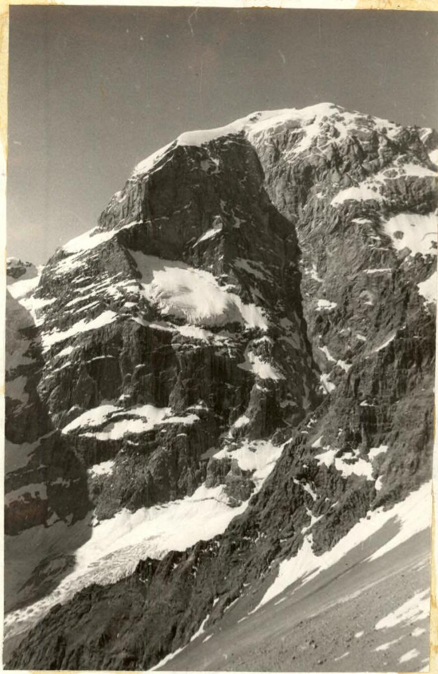
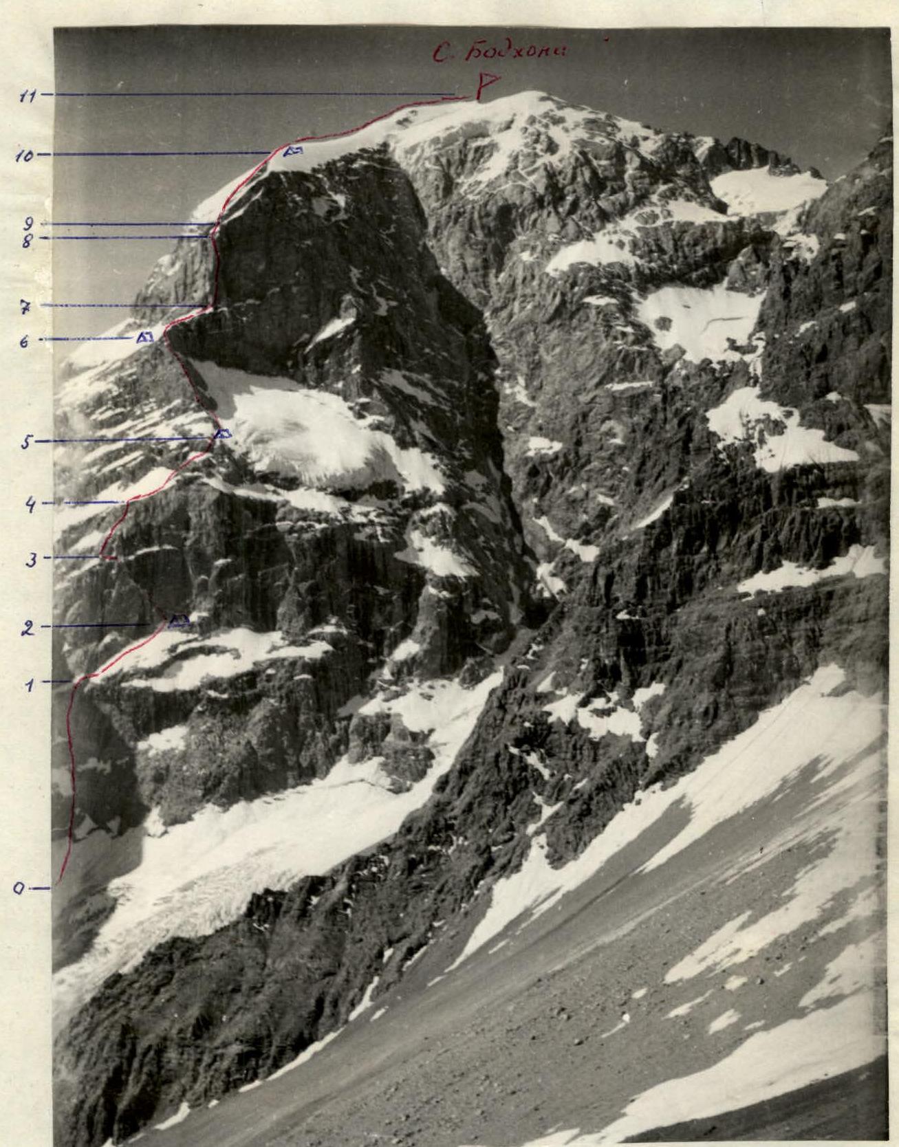
Route to peak S. Bodkhona via N. wall.
Description
of the route to peak S. Bodkhona via N. wall (Kudinov's route, 1970)
The northern wall of peak S. Bodkhona is bisected by a giant couloir into two parts. To the left of the couloir, in the center of the wall, there is a hanging glacier. To the left of the glacier, at its level, there is a ridge that drops down to the glacier with a wall divided by a large snow shelf into two ascents.
The route goes:
- along this wall,
- then along the ridge,
- straight up the second wall that the ridge abuts.
The first ascent of the lower wall is done in the left part, where the rocks are somewhat less steep than in the center. Above the right part of the wall hangs the aforementioned glacier, and from the eastern ridge of the peak to the left of the route, another glacier hangs. The falling ice from it limits the route on the left.
The base of the route is a bergschrund:
- According to our altimeter — 3200 m
- According to Kudinov's estimates — 3500 m
After the first ascent (section R0–R1, 400 m, 5) the route goes along a steep snow shelf to the right and up to the highest point of the shelf, after which the shelf begins to descend. There is a good bivouac spot there (3700 m).
On the shelf (section R1–R2, 360 m, 4–5):
- belay via ice axe,
- in places via rock pitons,
- in places from a running belay.
To the bivouac from the bergschrund — 6 h.
The second ascent of the wall is overcome by a large exfoliation to the left and up from the bivouac (section R2–R3, 250 m, 6). This section is a series of very difficult wall sections but with good ledges between them. In several places, the route goes under waterfalls from the right wall. It is recommended to pass this section in the morning, before the waterfalls gain strength.
The exfoliation leads to a shelf. Along the shelf to the left 25 m. Then to the right and up to the next large snow shelf (section R3–R4, 150 m, 5–6).
Along the snow shelves with rocky wall sections to the right and up (section R4–R5, 170 m, 4–5). The main landmark on this section is the beginning of the ridge. On the ridge is the second bivouac (height 4100 m).
In total, 10 climbing hours were spent on section R2–R5 for the day.
Along the ridge, the first 2–3 ropes are relatively easy, then it gets progressively harder up to 5 (section R5–R6; 440 m, 4–5).
Before the upper bastion — a good platform. Here is a bivouac and a control cairn in a cairn on the wall by the platform. On the same day, we managed to process 4 ropes of the upper bastion.
From the bivouac to the bastion 100 m of snow with rock outcrops (section R6–R7, 1).
On the bastion, there is a seemingly sheer counterfort that is a continuation of the ridge. It divides the bastion wall into NE and NW walls. The first ascendants climbed slightly to the left of the ridge. We chose a route slightly to the right.
The detour to the right and up — the base of the counterfort, then to the left and up along a stream (between the stream and the ridge, with an exit to the ridge). The last rope of this section — straight along the ridge.
Ascent sections:
- Section R7–R8, 320 m, 6
- Section R8–R9, 120 m, 4, 3 ice pitons
- Section R9–R10, 240 m, 4–5
Then along a snow-ice slope to a wall leading to the edge of a rocky-snowy-icy slope. The path goes along the edge until it reaches the icy summit ridge. Two ropes along the ridge and on its right side — to a talus platform for a bivouac. Height — 5000 m.
For the day (12 h) sections R6–R10 were passed.
From the bivouac to the summit along the icy ridge (section R10–R11, 700 m, 3, 3 h).
Descent from the summit 40 m along the W ridge towards Chapdara and to the left into a couloir. Having descended 40 m, traverse to the left and then down into a large couloir descending from the saddle between the N peak and a large gendarme (the gendarme is marked on some maps as the central peak of the Bodkhona massif). The descent is mostly downclimbing to the glacier. Then down to the icefall and along it to the right and down under the slopes of Chapdara and along snowfields down to the trail.
The descent to the trail takes 4–5 h.
TABLE OF TECHNICAL CHARACTERISTICS OF THE ROUTE
| Date / Section | Steepness, ° | Length, m | Terrain characteristics | Category of difficulty | Condition | Belay (rock) | Belay (ice) | Belay (stoppers and slings) | Total for the day (climbing hours, height difference) |
|---|---|---|---|---|---|---|---|---|---|
| July 22 R0–R1 | 70 | 400 | Rocky wall | 5 | Monolith | 12 | - | 10 | 6 h |
| R1–R2 | 45 | 360 | Snow shelf | 4–5 | — | 10 | - | 7 | 3700–3200 = 500 m |
| July 23 R2–R3 | 80 | 250 | Rocky wall | 5–6 | Monolith, wet | 29 | - | 6 | 10 h |
| R3–R4 | 70 | 150 | Rocky wall with shelves | 5–6 | Monolith, wet | 10 | - | 15 | — |
| R4–R5 | 50 | 170 | Snow shelves with rocky wall sections | 4–5 | — | 6 | - | 9 | 4100–3700 = 400 m |
| July 24 R5–R6 | 50 | 440 | Rocky ridge | 4–5 | Monolith, overlapping slabs | 22 | - | 20 | 5 h + 4 h recon., 4600–4100 = 500 m |
| July 25 R6–R7 | 40 | 100 | Snow with rock outcrops | 1 | — | - | - | 3 | 12 h |
| R7–R8 | 85 | 320 | Rocky wall | 6 | Monolith | 32 | - | 25 | — |
| R8–R9 | 35 | 120 | Snow-ice | 4 | Thin snow on ice | - | 4 | - | — |
| R9–R10 | 35 | 240 | Slabs to the left of the edge | 4–5 | Monolith, snowed, iced | 16 | - | - | 5000–4600 = 400 m |
| July 26 R10–R11 | 30 | 700 | Icy ridge | 3 | Ice with small calgasporas | - | - | - | 3 h, 5300–5000 = 300 m |