Passport
I. Technical Class 2. Fann Mountains 3. Bodhona Peak, via the left part of the western wall, Zhitenev's route 4. Height difference: 965 m, length 1120 m. Length of sections: 6th cat. diff. – 540 m, 5th cat. diff. – 210 m. Average steepness of the route is 85°. 5. Number of pitons:
| rock | bolt | chock | ice screws | 'friends' |
|---|---|---|---|---|
| 231 | 18 | 150 | 3 | 41 |
| 9 | 0 | 2 | 0 | 0 |
X — use of previously hammered pitons.
- Team's moving hours: 45 hours and days — 4.
- Overnights: after processing — under the route, 1st bivouac on a snow shelf, 2nd bivouac, 3rd bivouac on a scree shelf.
- Leader: Mikheev Alexander Borisovich — Candidate Master of Sports Participants:
- Gostishchev Sergey — Candidate Master of Sports
- Myakotnikov Alexey Alekseevich — 1st sports category
- Pupyrhev Konstantin Valerievich — 1st sports category
- Sysoletin Nikolay Egorovich — 1st sports category
- Chashchin Sergey Anatolievich — 1st sports category
- Coach: Kubonina Tamara Vasilievna — Master of Sports of the USSR
- Route processing: July 19, 1989.
Departure on the route: July 21, 1989. Summit: July 24, 1989. Return: July 24, 1989.
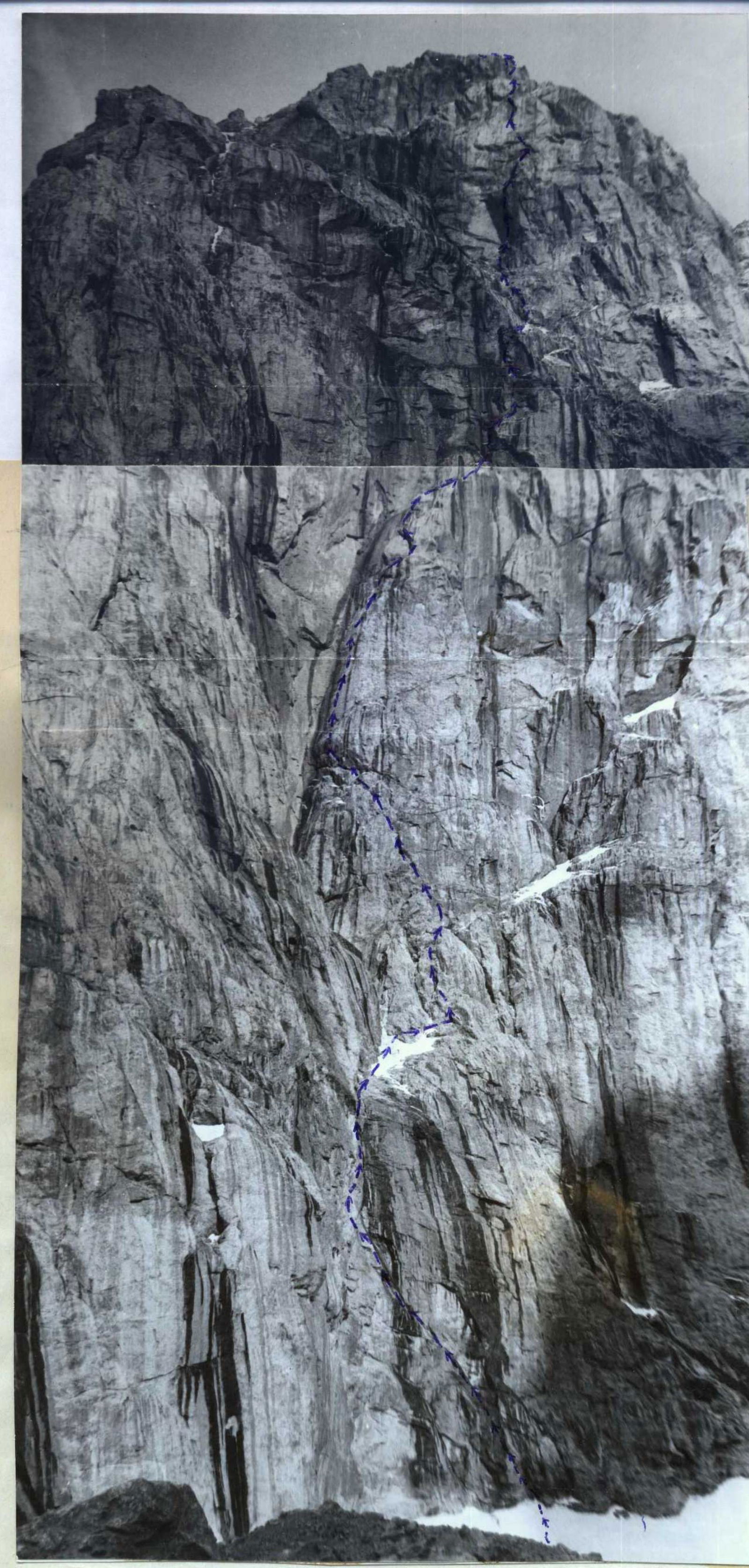
Photo from the Morena glacier of Bodhona, July 18, 1989, distance 15 km, lens "Helios-44M", focal length 2/58.
Route Diagram
Route diagram in UIAA symbols. Number of pitons: rock (RP) 231/9, bolt 18, ice screws 3, chocks 150/2, 'friends' 41.
| RP | BA | IA | Chock | FR | cat. diff. of section | Length | Steepness | Section # |
|---|---|---|---|---|---|---|---|---|
| 5 | - | - | 2 | 1 | III | 200 | 35 | 33 |
| 10 | - | - | 6 | 2 | AeII | 40 | 90 | 32 |
| 10 | - | - | 5 | 3 | AeII | 40 | 90 | 31 |
| 9 | - | - | 7 | 2 | AeII | 30 | 100 | 30 |
| 11 | 1 | - | 5 | 1 | AeII | 30 | 95 | 29 |
| 10 | - | - | 6 | 1 | AeIII | 25 | 100 | 28 |
| 8 | - | - | 6 | 2 | AeI | 40 | 90 | 27 |
| 8 | - | 1 | 5 | 1 | VI | 40 | 85 | 26 |
| 5 | - | - | 4 | - | V | 40 | 70 | 25 |
| 8 | 1 | - | 4 | 2 | AeIII | 30 | 90 | 24 |
| 10 | 2 | - | 5 | 1 | AeIII | 30 | 95 | 23 |
| 8 | - | - | 4 | 2 | VI | 35 | 80 | 22 |
| 6 | 1 | 1 | 4 | 2 | I | 35 | 75 | 21 |
| 5 | - | - | 5 | - | V | 30 | 80 | 20 |
| 4 | - | - | 4 | - | V | 30 | 70 | 19 |
| 7 | - | - | 5 | 1 | AeII | 20 | 85 | 18 |
| 6 | 1 | - | 4 | 2 | AeII | 25 | 85 | 17 |
| 7 | 2 | - | 5 | 1 | AeII | 25 | 85 | 16 |
| 8 | 2 | - | 4 | 2 | AeII | 20 | 80 | 15 |
| 10 | - | - | 5 | 4 | AeII | 20 | 90 | 14 |
| 4 | - | - | 2 | 1 | IV | 15 | 30 | 13 |
| 4 | - | - | 4 | 1 | V | 30 | 80 | 12 |
| 6 | 2 | - | 4 | 2 | VI | 35 | 90 | 11 |
| 5 | - | - | 5 | 1 | V | 30 | 75 | 10 |
| 4 | - | 1 | 4 | 1 | V | 30 | 80 | 9 |
| 5 | - | - | 2 | - | III | 80 | 40 | 8 |
| 7 | - | - | 4 | 1 | AeI | 30 | 90 | 7 |
| 10 | 2 | - | 5 | 2 | AeII | 35 | 90 | 6 |
| 6 | - | - | 4 | 1 | AeII | 15 | 75 | 5 |
| 8 | 2 | - | 5 | 1 | AeII | 15 | 75 | 4 |
| 7 | 1 | - | 7 | - | AeII | 10 | 75 | 3 |
| 9 | - | - | 6 | - | AeII | 25 | 90 | 2 |
| 10 | 1 | - | 5 | 1 | AeII | 20 | 85 | 1 |
Description of the Route by Sections
Section R0–R1: approach under the wall via steep firn. Need to approach in the morning, as stones start flying during the day. Section R1–R4: smooth walls, covered with flow ice. Climbing is difficult, use ITO. Section R4–R8: inclined slab. Water flows down the slab. There are belay points (bolts). Use ITO when passing. Section R8–R9 — snow-ice inclined shelf. At the beginning of the shelf — a control cairn. Section R9–R12 — difficult climbing on destroyed rocks. Very prone to rockfall. There are bivouac sites. Section R12–R19 — a smooth, slightly inclined slab and the rest of the wall form a large internal angle. Climb the slab, along the center of which runs a crack.
- Start — vertical wall — is passed on ITO.
- Further — along the crack.
- Use 'friends'.
- The entire section is shot with ice flying from the Bodhona dome.
- Need to use ITO.
Section R19–R22 — chimneys covered with flow ice alternate with overhanging sections. Prone to rockfall. Easy climbing alternates with ITO passage. Between R23 and R24 there is a good bivouac site.
Section R28–R32 — Bastion — an overhanging rock, along the center of which passes a chimney, sometimes narrowing, sometimes expanding, covered with flow ice. Climbing is very difficult. Use of ITO.
Section R32–R33 — Scree shelves. Easy rocks are found. Lots of snow. 2 hours walk to the summit.
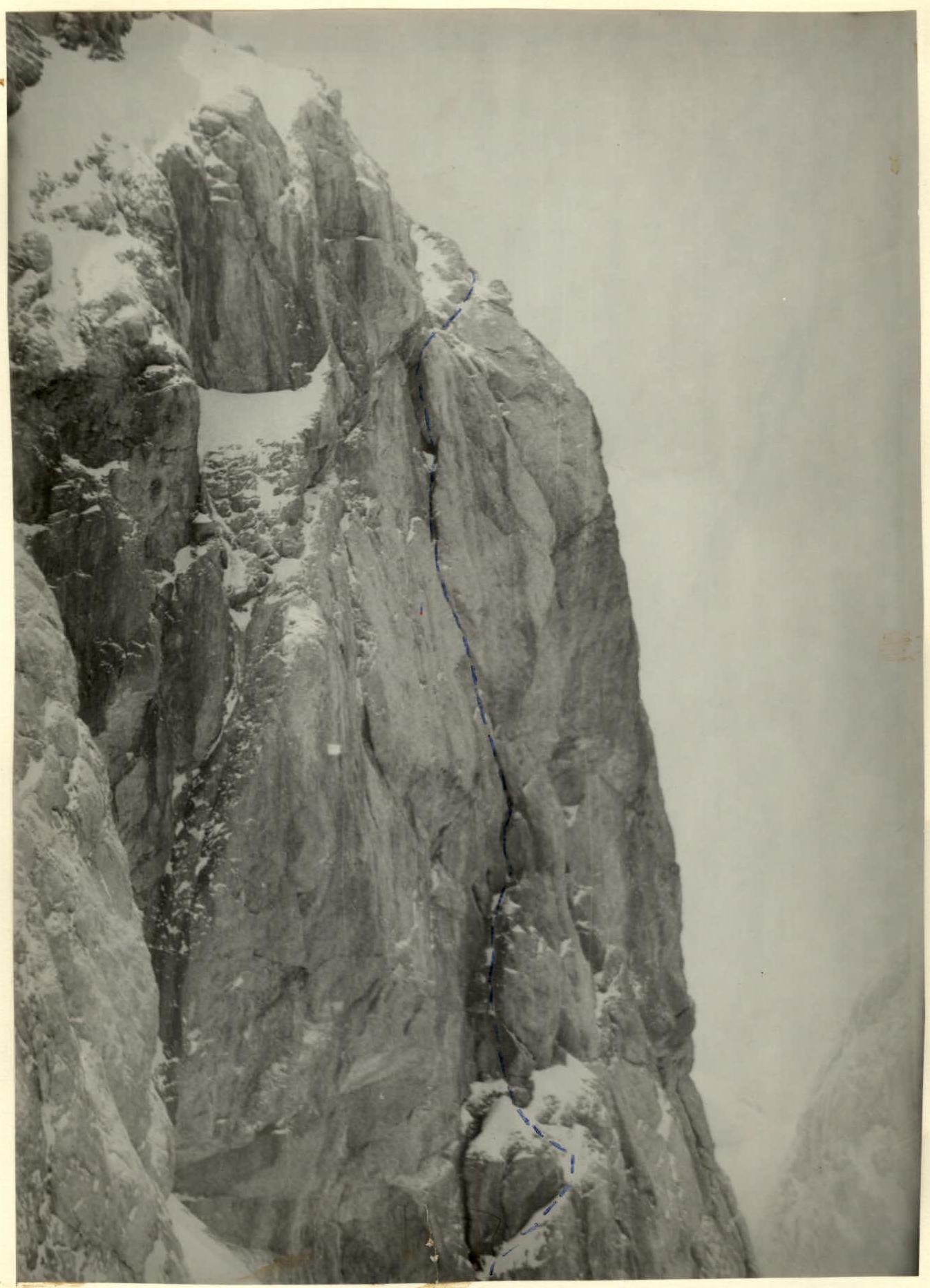
Bastion. Upper part. Shot from the beginning of the descent — Gulynev's route.