Ascent Log
- Ascent class: technical
- Ascent area: Gissar Ridge
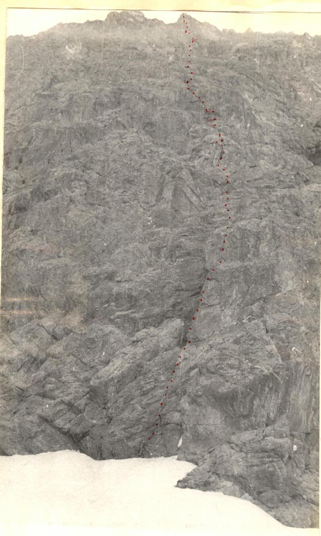
- Peak, its height, and ascent route: Mt. Aurondagh, 4573 m, via the Central North wall
- Difficulty category: 5B, second ascent
- Route characteristics: total elevation gain 978 m, average steepness 73°, technical sections 80°, route length 1197 m and sections by difficulty category (m)
| Difficulty Category | Length (m) |
|---|---|
| 1 | — |
| 2 | — |
| 3 | 270 |
| 4 | 139 |
| 5 | 716 |
| 6 | 72 |
-
Pitons used: for belaying: rock 121 ice 17 bolted — for creating I.T.O.: 4
-
Total travel time: 20 hours
-
Number of bivouacs and their characteristics: 1 — semi-reclined
-
Surname, name, patronymic of the leader and participants, and their sports qualification:
- Kompaneyets Igor Vasilievich — leader, Candidate for Master of Sports
- Burenin Yuri Alexandrovich — participant, Candidate for Master of Sports
- Samsonov Vladimir Anatolievich — participant, 1st sports category
- Khan Viktor Irgonovich — participant, 1st sports category
-
Date of departure on the route: June 28, 1978, and return from the route: June 29, 1978
-
Team coach: Master of Sports of the USSR Kiselev Anatoly Mikhailovich
AURONDAGH
Table of Main Route Characteristics
route: Mt. Aurondagh via the center of the North wall elevation gain: including technically complex section: average steepness: including technically complex section: Number of pitons used: – rock — 121 – ice — 17 – bolted — —
June 28–30
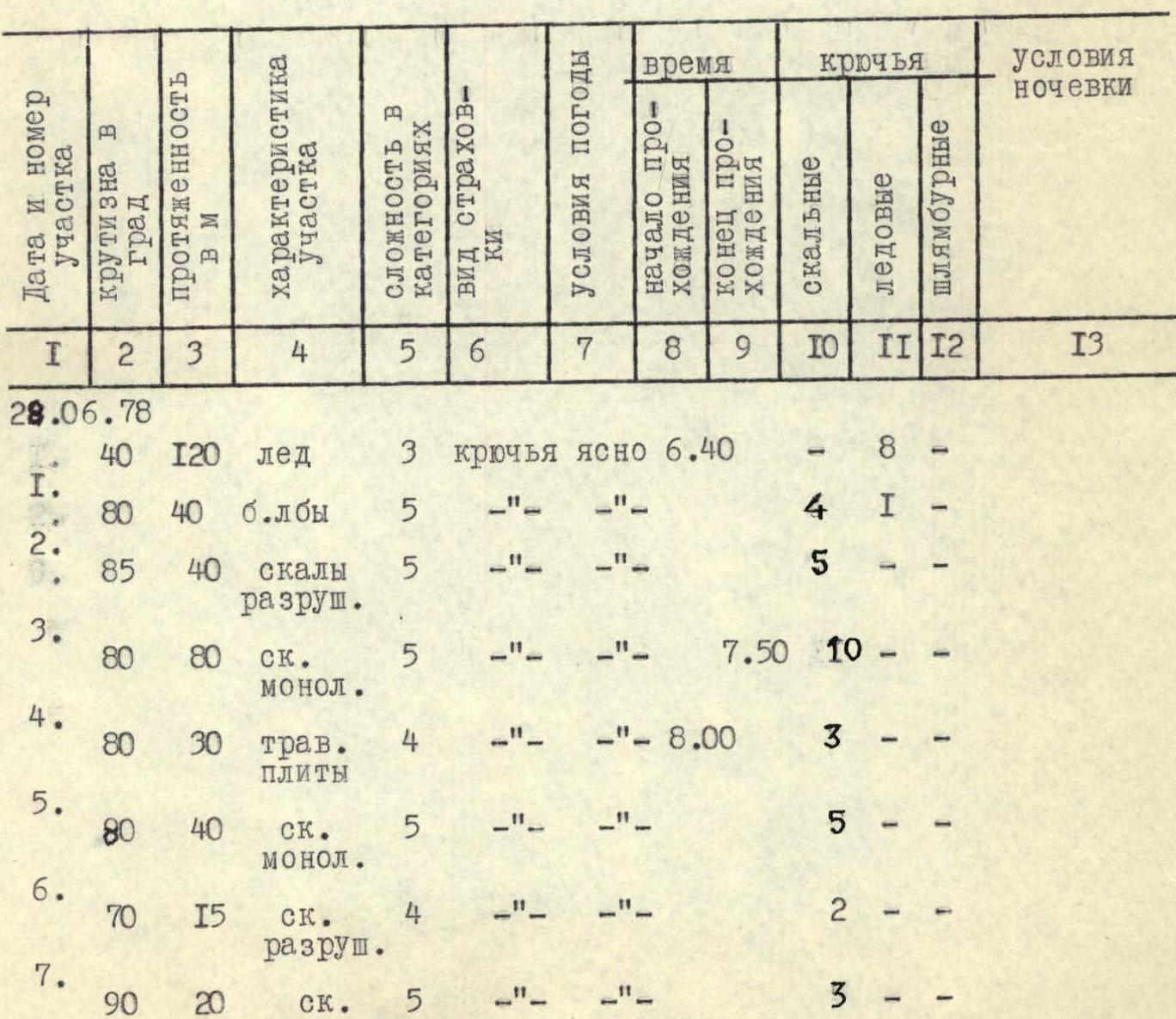
| Date and Sec. No. | Steepness (°) | Length (m) | Section Characteristics | Diff. Cat. | Belay Type | Weather Conditions | Start Time | End Time | Rock Pitons | Ice Pitons | Bolted | Bivouac Conditions |
|---|---|---|---|---|---|---|---|---|---|---|---|---|
| 28.06.78 | ||||||||||||
| 40 | 120 | ice | 3 | pitons | clear | 6:40 | — | 8 | — | |||
| R1 | 80 | 40 | "ram's foreheads" | 5 | " | " | 4 | 1 | — | |||
| R2 | 85 | 40 | crumbly rock | 5 | " | " | 5 | — | — | |||
| R3 | 80 | 80 | monolithic rock | 5 | " | " | 7:50 | 10 | — | — | ||
| R4 | 80 | 30 | grassy slabs | 4 | " | " | 8:00 | 3 | — | — | ||
| R5 | 80 | 40 | monolithic rock | 5 | " | " | 5 | — | — | |||
| R6 | 70 | 15 | crumbly rock | 4 | " | " | 2 | — | — | |||
| R7 | 90 | 20 | crumbly rock | 5 | " | " | 3 | — | — | |||
| R8 | 90 | 35 | chimney | 5 | pitons | clear | 1 | — | — | |||
| R9 | 90 | 40 | chimney | 5 | " | " | 11:10 | 3 | — | — | ||
| R10 | 85 | 15 | crumbly rock | 5 | " | " | 11:15 | 2 | — | — | ||
| R11 | 85 | 40 | grassy wall | 6 | " | " | 10 | — | — | |||
| R12 | 80 | 30 | crevice | 5 | " | " | 3 | — | — | |||
| R13 | 75 | 40 | crumbly rock | 5 | " | " | 3 | — | — | |||
| R14 | 80 | 15 | monolithic | 5 | " | " | 3 | — | — | |||
| R15 | 92 | 2 | monolithic | 6 | " | " | 3 | — | — | |||
| R16 | 85 | 50 | inner corner | 5 | " | " | 10 | — | — | |||
| R17 | 90 | 20 | crevice | 5 | " | " | 3 | — | — | |||
| R18 | 75 | 10 | crumbly rock | 4 | " | " | 1 | — | — | |||
| R19 | 90 | 3 | monolithic rock | 5 | " | " | 1 | — | — | |||
| R20 | 85 | 17 | crumbly rock | 5 | " | " | 3 | — | — | |||
| R21 | 85 | 25 | crumbly rock | 5 | " | " | 16:40 | 4 | — | — | ||
| R22 | 65 | 10 | talus, ledges | 5 | " | " | 17:10 | 2 | — | — | ||
| R23 | 60 | 5 | ledges | 4 | " | " | — | — | — | |||
| R24 | 80 | 35 | inner corner | 4 | " | " | 3 | — | — | |||
| R25 | 85 | 40 | crumbly rock | 5 | " | " | 5 | — | — | |||
| R26 | 75 | 10 | grassy ledges | 5 | " | " | 2 | — | — | |||
| R27 | 80 | 15 | crumbly rock | 5 | " | " | 3 | — | — | |||
| R28 | 80 | 20 | crumbly rock | 5 | " | " | 20:10 | 4 | — | — | ||
| 29.06.78 | sitting | |||||||||||
| R29 | 70 | 30 | ice | 5 | " | cloudy | 7:00 | — | 8 | — | ||
| R30 | 75 | 4 | grassy ledges | 5 | " | " | 8:00 | 1 | — | — | ||
| R31 | 80 | 40 | monolithic rock | 4 | " | " | 8:00 | 6 | — | — | ||
| R32 | 80 | 10 | grassy ledges | 5 | pitons | cloudy | 2 | — | — | |||
| R33 | 90 | 5 | crevice | 6 | " | " | 2 | 11 | — | |||
| R34 | 90 | 15 | grassy ledges | 6 | " | " | 6 | — | — | |||
| R35 | 90 | 10 | monolithic rock | 6 | " | " | 10:40 | 5 | 11 | — | ||
| R36 | 75 | 17 | monolithic rock | 5 | " | " | 10:40 | 3 | — | — | ||
| R37 | 75 | 5 | grassy ledges | 5 | " | " | 1 | — | — | |||
| R38 | 80 | 15 | monolithic rock | 5 | " | " | 1 | — | — | |||
| R39 | 80 | 4 | grassy ledges | 4 | " | " | 1 | — | — | |||
| R40 | 80 | 30 | crumbly rock | 5 | " | " | 12:10 | 3 | — | — | ||
| R41 | 65 | 150 | ridge | 3 | rock outcrops | " | 12:10 | 12:30 | 1 | — | — | |
| R42 |
Approach to the Route (June 27, 1978)
The team left the base camp at 12:00. Passing through the Artuch tourist camp, they ascended along the trail to Lake Chukurak by 13:00. They reached Lake Ziyarat, located in the same valley upstream, by 14:00. From Lake Ziyarat, the ascent up the left part of the long, steep talus slope to the glacier took 1.5 hours. They set up camp on the rightmost moraine of the glacier, directly opposite the North wall of Mt. Aurondagh, by 17:00. The approach from the camp to the wall took 30 minutes.
Brief Explanations for the Table (June 28, 1978)
They left the camp at 6:00 and began working on the wall at 6:40.
- Initially, they ascended steep ice to the "ram's foreheads" between two waterfalls.
- Then, they went up smooth rock slabs covered with thin ice and water.
- To reach the first bastion, they moved one rope length up the right part of the wall.
- The first bastion was climbed by first traversing left and then going straight up.
- 1st control cairn.
They traversed across slabs to an inner corner. Then, they moved another rope length up and to the right through a slight overhang and one rope length under chimneys. Two consecutive chimneys led them to a rock outcropping. Initially, they went up and then made a difficult traverse to the right. Then, they ascended 30 m to the left and up through a crevice. At this point, they pulled up their backpacks for 60 m. Then:
- they ascended under an osypnoy inner corner — one rope length,
- 15 m up through an overhang — exit to an inner corner,
- along which 50 m to convenient ledges.
Through a crevice with a cornice at the exit, they moved up the ledges for 30 m, then 3 m up and to the left, and 17 m up and to the right. Then, they moved 25 m up and to the left again, exiting into a small talus-filled couloir. The third control cairn. From the cairn, they traversed left along an osypnoy ledge to a small grotto. Then, they moved left and up through a large inner corner, and to the left across dirty slabs — two rope lengths. Another rope length up a wall led them to a convenient ledge. Then, they moved left behind a rock, then right into an inner corner, and left again to the base of a steep ice couloir. Here, they set up a sitting bivouac at 20:30 on June 28, 1978.
They started working again at 7:00. They ascended 30 m up the ice wall of the couloir and across osypny ledges to the left onto a shoulder under the pre-summit bastion. Another rope length up led them under a red triangle with quartz outcroppings. Then, they moved along a ledge leftward along a slab and through a crevice, using ladders. A traverse to the right under a quartz "lens" included a 10 m extremely problematic section. At the top, they found the 5th control cairn.
From the cairn, they ascended 17 m straight up through crevices to the top of the triangle ("sail"). Then:
- they traversed 5 m to the right,
- encountered another cornice,
- and then moved up to a ledge. From the ledge:
- they went 4 m to the right,
- then left and up along an outer corner,
- exiting onto the ridge. Opposite the exit, a small grotto in the rock was visible.
Along the ridge, staying on the right side, they reached the summit. They were on the summit by 12:30. At 13:00, they began their descent via the 3B category route.