Ascent Passport
- Ascent class: technical
- Ascent area: Pamir-Alay (Fann Mountains)
- Peak: Aurondag, 4573 m, via the center of the northeast wall's "triangle"
- Estimated difficulty category: 5B
- Route characteristics:
- Elevation gain: 1000 m
- Average slope: 75°. Section lengths:
- R3 — 500 m
- R4 — 200 m
- R5 — 550 m
- R6 — 300 m
- Pitons used: 203 rock pitons for belaying, 16 rock pitons for ITO; 10 ice pitons; no bolt pitons.
- Total climbing time: 39.5 hours
- Number of bivouacs: 3: 1 — snow platform, reclining; 2 — rocky ridge with snow; 3 — under a cornice in a couloir, sitting.
- YEFREMOV NEOFIT LAVRENT'EVICH — CMS — team leader; ANDREEV SERGEY VADIMOVICH — CMS; BALAKIN ANATOLY VALENTINOVICH — CMS; MONAENKOV YEVGENIY IVANOVICH — CMS.
- Team coach: DEMMENKO ALEKSANDR STEPANOVICH — MCMS.
- The team started the ascent on June 13, 1978, and returned to base camp on June 17, 1978.

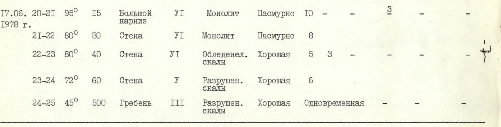
Table
Characteristics of the route to peak AURONDAG via the center of the NE wall, estimated 5B category.
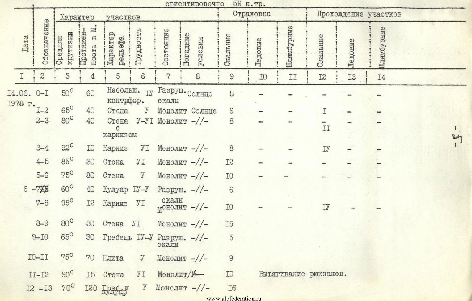

| Date | Section | Average slope | Length, m | Terrain/section characteristics | Difficulty | Condition | Weather | Belay (rock) | Belay (ice) | Belay (bolts) | Climbing (rock) | Climbing (ice) | Climbing (bolts) |
|---|---|---|---|---|---|---|---|---|---|---|---|---|---|
| June 14, 1978 | R0–R1 | 50° | 60 | Small counterfort | U | Destroyed | Sun | 5 | |||||
| R1–R2 | 65° | 40 | Wall | U | Monolith | Sun | 6 | I | |||||
| R2–R3 | 80° | 40 | Wall with cornice | U–VI | Monolith | 8 | II | ||||||
| R3–R4 | 92° | 10 | Cornice | VI | Monolith | 8 | IV | ||||||
| R4–R5 | 85° | 30 | Wall | VI | Monolith | 12 | |||||||
| R5–R6 | 75° | 80 | Wall | U | Monolith | 10 | |||||||
| R6–R7 | 60° | 40 | Couloir | IV-U | Destroyed | 6 | |||||||
| R7–R8 | 95° | 12 | Cornice | VI | Monolith | Rocks | 10 | IV | |||||
| R8–R9 | 80° | 30 | Wall | VI | Monolith | 15 | |||||||
| R9–R10 | 65° | 30 | Ridge | IV-U | Destroyed | Rocks | 5 | ||||||
| R10–R11 | 75° | 70 | Slab | U | Monolith | 9 | |||||||
| R11–R12 | 90° | 15 | Wall | VI | Monolith | 10 | Pulling backpacks | ||||||
| R12–R13 | 70° | 120 | Couloir | U | Monolith | 16 | |||||||
| June 15, 1978 | R13–R14 | 80° | 50 | Chimney with a plug | VI | Monolith | Overcast | 10 | 2 | ||||
| R14–R15 | 60° | 40 | Ridge and internal corner | U | Destroyed | Overcast | 7 | ||||||
| R15–R16 | 85° | 40 | Wall | Destroyed | Wind, snow grains | 15 | 3 | ||||||
| R16–R17 | 70° | 70 | Couloir | IV-U | Icy | Wind, snow | 7 | 3 | |||||
| June 16, 1978 | R17–R18 | 55° | 70 | Snow-ice ridge | III-IV | Destroyed | Overcast | 4 | 4 | ||||
| R18–R19 | 75° | 80 | Wall | U | Monolith | Fog, Overcast | 11 | ||||||
| June 17, 1978 | R19–R20 | 85° | 80 | Couloir | VI | Destroyed | Rain with snow | 16 | Pulling backpacks | ||||
| R20–R21 | 95° | 15 | Large cornice | VI | Monolith | Overcast | 10 | 3 | |||||
| R21–R22 | 80° | 30 | Wall | VI | Monolith | Overcast | 8 | ||||||
| R22–R23 | 80° | 40 | Wall | VI | Icy | Good | 5 | 3 | |||||
| R23–R24 | 72° | 60 | Wall | U | Destroyed | Good | 6 | ||||||
| R24–R25 | 45° | 500 | Ridge | III | Destroyed | Good | Simultaneous |

Departed at 7:30, reached bivouac at 15:30. Climbing time: 7 hours. Night's rest was sitting under a large cornice at the end of a couloir. Control point №2.
Departed at 7:30, reached the summit at 14:00. Descended to a moraine bivouac by 19:00. Climbing time: 11 hours 30 minutes.
SUMMARY:
- Total pitons used on the route: 219 rock, 10 ice, 16 for ITO
- Team captain MVO: (Yefremov N. L.)
Explanation of the table
Description of the route to peak Aurondag via the center of the NE wall, estimated 5B category.
June 13, 1978. Departed from the gathering camp of the USSR Climbing Federation, located below Kulikolonskie lakes, and approached the peak in 3.5 hours. Overnight location.
June 14, 1978. Departed from the moraine bivouac at 6:00. Reached the NE wall of peak Aurondag via the glacier in 1.5 hours. The wall looms like a huge black "triangle"; the route goes through the center of this "triangle". A small counterfort protruding from the lower part of the wall marks the beginning of the route.
- Along this counterfort — 40 m of moderately difficult rock climbing (R0–R1)
- Then, upwards to the right — one rope length of difficult climbing (R1–R2) with few cracks.
- Upwards to the right along the wall, skirting a hanging section, and left along an inclined ledge, bypassing a cornice on the right — entering under the 2nd large cornice (R2–R3) — 40 m of complex climbing.
- From under the cornice, left and down, then straight up and right onto an inclined ledge (R3–R5) — one rope length.
A total of 160 m was covered. From here begins the section of large cornices.
- From the inclined ledge, left and up to the right edge of a large couloir, and along its edge under a large red cornice. Here is the 1st control point. 280 m covered (R6–R7).
- Bypassing the cornice on the right along the overhanging wall (R7–R8), exiting left and up, and reaching a ridge (R9–R10) on the left side of the second large red cornice — 50 m.
- Up along the ridge to a huge gray slab extending to the right.
- Along the slab to the slab's comb (R10–R11) — complex climbing, 70 m.
- From the comb, straight up along a vertical wall and a small overhang — 15 m, with backpacks being pulled up.
- From here, left and up under the wall towards a snowy comb — 60 m.
- Then, right and up — 50 m along a crack and 10 m left along a steep couloir (R12–R13) to the bivouac site, a small snow platform.
June 15, 1978. From the bivouac site at 8:00.
- Straight up — 50 m (R13–R14) to the start of a chimney with a "live" plug at its top, few places for piton placement.
- Then up along a poorly defined comb — 40 m to an internal corner (R14–R15).
- Along the overhanging corner using artificial holds — very difficult climbing, approaching a wall on the left along a ledge.
- The wall is heavily destroyed, hazardous.
- Up the wall — 40 m to the start of a snowy comb (R15–R16).
- Along the boundary between snow and rocks to the next wall, and up the wall and a wide rocky couloir (R16–R17), rocks heavily smoothed and covered with ice, exiting onto a snowy ridge — to the second bivouac site (R16–R17).
June 16, 1978. From the bivouac site at 7:30.
- Along the snowy ridge — 70 m with rocky outcrops (R17–R18) under the wall.
- Along the wall (R18–R19) right and up towards a large couloir — 80 m, a section of complex climbing (R19–R20).
- For the first 40 m — pulling up backpacks.
- Then along the large couloir (R20–R21) — 80 m under the base of a large yellow cornice.
- Climbing in the couloir is complicated by wet rocks, which are partially overhanging, and numerous loose rocks.
At 14:00, the weather finally deteriorated: fog, wet snow. Forced to stop under the large cornice and organize a sitting bivouac. One pair continued processing. Here, a second control point was left.
June 17, 1978. From the bivouac site at 7:30.
- Along the pre-fixed ropes — 40 m, a complex exit from under the cornice to the left (R21–R22) and, with a subsequent traverse, exiting onto a ledge.
- Then left and up onto icy rocks (R22–R23) — very complex 40 m, passing between a giant icicle and the wall, leading away from the wall's corner.
- From here, up — two rope lengths along complex, destroyed rocks (R23–R24) with an exit onto a straightforward ridge leading to the summit.
- Along the straightforward ridge (R25) to the summit of peak Aurondag — 30 minutes.
Descent towards the pass between peak Zierat and peak Aurondag via the route of 3B category (along the North Ridge) to a moraine bivouac took 4 hours.
General conclusion on the route
The route along the Northeast wall to peak Aurondag is interesting and logical.
The route is tense and lengthy, requiring participants to have good physical and technical preparedness.
The slope of key sections ranges from 80° to 95°. Technically, the route is complex, necessitating careful equipment selection and mastery of advanced rock climbing techniques and tactics of modern wall climbing.
The entire route should be climbed in rubber boots (galoshes or "vibram" type boots).
The chimney section in the upper part of the wall must be climbed one by one to avoid accidental rockfall, snow, and ice.
There are sections with verglas, significantly complicating the route.
It is recommended to climb this route in the second half of the season.
Bivouac sites are available on the route as described. For insurance and self-insurance, 220 rock and 10 ice pitons were used on the route. For creating artificial holds, 16 rock pitons were used.
Backpacks were repeatedly pulled up on complex rock terrain.
Based on experience from ascents of 5B and 6 categories in the Caucasus and Fann Mountains (peak Jailyk via the South wall of the SW counterfort 5B, peak Ullutau-Chana Main via the North wall 5B, peak Ushba via the SE ridge 5B, peak Mikhirgi 5B, peak Zindon via the North wall 6 category), the team members believe that the route to peak Aurondag via the NE wall corresponds to the 5B category and can be recommended for teams with sufficient experience in climbing peaks of 5B category.