- The ascent class is technical.
- The ascent area is the Fan Mountains, Zarafshan Range.
- The peak, its height, and the ascent route: peak Amshut, 4850 m, via the center of the north wall, first ascent.
- The proposed category of difficulty is 5B.
- Characteristics of the route: height difference — 1050 m, route length — 1200 m, length of sections 5–6 — 1150 m, including sections 6 — 280 m, average steepness of the route — 70°.
- Number of pitons driven: rock pitons — 205, including for ITO — 11, chocks — 115, including for ITO — 5, bolt pitons — 2.
- Number of walking hours to the summit — 35 hours.
- Number of bivouacs and their characteristics: two bivouacs — one semi-reclining, one reclining.
- Name of the team leader, participants, and their qualifications: Mumdzhi T.M., Master of Sports of the N Soviet Union — team leader, Dronov Yu.V., Candidate for Master of Sports, Fevziev R.F., Candidate for Master of Sports, Babeshko V.P., Candidate for Master of Sports, Valiulin E.A., Candidate for Master of Sports, Smirnov G.K., Candidate for Master of Sports, Gornostaev V.V., Candidate for Master of Sports, Tishchenko V.I., 1st sports category.
- Team coach — Mumdzhi T.M., Master of Sports of the N Soviet Union, instructor-methodologist of the 1st category.
- Date of departure and return: departure on the route — July 26, 1980, return — July 28, 1980.
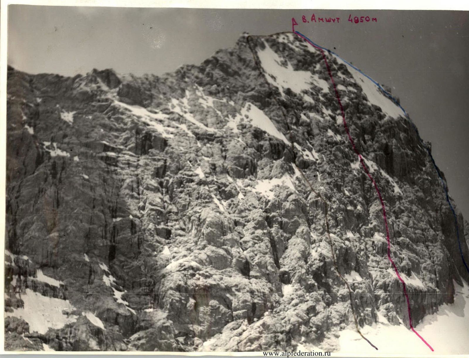
- ROUTE TAKEN BY THE TEAM ON PEAK Amshut VIA THE CENTER OF THE NORTH WALL IN 1980.
- ROUTE FROM PASS Amshut 5B CATEGORY OF DIFFICULTY TO PEAK Amshut 1974.
- ROUTE VIA THE LEFT PART OF THE NORTH WALL 5B (NOT CLASSIFIED), 1980.
- The ascent class is technical.
- The ascent area is the Fan Mountains, Zarafshan Range.
- The peaks, their heights, and the ascent route: Amshut (4850 m), Moscow-Zerafshanskaya (5183 m), Sakharnaia golova (4970 m) — traverse with ascent via the center of the north wall, first ascent.
- The proposed category of difficulty is 5B.
- Characteristics of the route (traverse): height difference — 4450 m, route length — about 4000 m, length of sections 5–6 — 1400 m, average steepness of the route — 50°, average steepness of the wall section — 70°.
- Number of pitons driven: rock pitons — 220 pieces, chocks — 120 pieces, ice pitons — 14 pieces, bolt pitons — 2 pieces.
- Number of walking hours — 54.
- Number of bivouacs and their characteristics:
four bivouacs:
- one semi-reclining,
- three reclining.
- Name of the team leader, participants, and their qualification: Mumdzhi T.M., Master of Sports of the N Soviet Union — team leader, Dronov Yu.V., Candidate for Master of Sports, Devziev R.F., Candidate for Master of Sports, Babeshko V.P., Candidate for Master of Sports, Valiulin E.A., Candidate for Master of Sports, Smirnov G.K., Candidate for Master of Sports, Gornostaev V.V., Candidate for Master of Sports, Tishchenko V.I., Candidate for Master of Sports, 1st sports category.
- Team coach — Mumdzhi T.M., Master of Sports of the N Soviet Union, instructor-methodologist of the 1st category.
- Date of departure and return:
departure on the route — July 26, 1980, return — July 30, 1980.
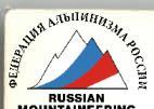
- TRAVERSE OF PEAKS COMPLETED BY THE TEAM IN 1980.
- ROUTE FROM PASS Amshut 5B CATEGORY OF DIFFICULTY TO PEAK Amshut, 1974.
- ROUTE VIA THE LEFT PART OF THE NORTH WALL 5B CATEGORY OF DIFFICULTY (NOT CLASSIFIED) TO PEAK Amshut, 1980.
- ROUTE VIA THE NORTH WALL 5B–6 CATEGORY OF DIFFICULTY (NOT CLASSIFIED) TO PEAK Moscow (Shumilov's route)
- TRAVERSE OF PEAKS SAKHARNAIA GOLOVA — Moscow — Block 5B CATEGORY OF DIFFICULTY
Preparation for the Ascent and its Implementation
The north wall of peak Amshut has long attracted our attention as a potential ascent route. We began studying it back in 1976, and by the time we started the ascent, we had a fairly comprehensive understanding of both the north wall of peak Amshut and the subsequent traverse of this mountain massif to peak Sakharnaia golova.
The team was both technically and physically prepared for the challenging north wall of peak Amshut. The subsequent traverse of the peaks was relatively straightforward. In the current season, before embarking on the traverse, team members had completed several training and competitive ascents, including one or two ascents of 5B category of difficulty. The team has significant experience with ascents of the highest category of difficulty, including routes of category 6.
We also had the most modern equipment:
- lightweight nylon tents and backpacks
- lightweight down gear
- nylon ropes
- titanium carabiners
- a wide range of pitons and chocks, etc.
The selection of food for the ascent was also well-planned, considering both variety and weight, as well as caloric content.
On July 22 of the same year, the main group of 14 people was at Lake Bol'shoe Allo.
The following plan was drawn up for the ascent and traverse:
- July 24 — transition of the main group to the base of the north wall of peak Amshut, setting up a storm camp.
- July 25 — observation of the wall to choose a safe ascent route and safe bivouac locations on the route.
- July 26 — passage of the lower rock bastion of the central part of the north wall of peak Amshut.
- July 27 — passage of the middle part of the route.
- July 28 — passage of the upper part of the route, exit to peak Amshut, and descent to the saddle between peaks Amshut and Moscow.
- July 29 — ascent to peak Moscow and descent to the saddle between peaks Moscow and Sakharnaia golova.
- July 30 — ascent to peak Sakharnaia golova, descent via the ascent route to the saddle, and further descent into the Akhbasoi valley, returning via pass Dvoinyi to the Zindon valley.
- July 31 — return to the base camp at Lake Bol'shoe Allo.
Visual observation (also using a 12x field binocular) of the north wall of peak Amshut, detailed study of the lower part and the entire central part of the wall vertically, observation of the pattern of rockfall, and examination of the base of the wall — all this allowed us to choose a safe ascent route via the center of the north wall and locations for protected bivouacs. To ensure safety, the route was planned vertically, with bivouacs under overhangs. Along the entire length of the route planned for ascent, only two sections are relatively hazardous due to the possibility of direct rockfall:
- the first section — a firn slope approximately 30 m long after the lower rock bastion,
- the second section — a snow-ice slope approximately 20–30 m long in the middle part of the wall.
These sections were decided to be traversed quickly and individually (using top-rope protection and observation), and after 16:00, when the entire wall from base to summit is in shadow (in the early hours of the morning, only the summit snow-ice dome is illuminated, and rockfall is possible). The snow-ice slope at the approach to the start of the route is also relatively hazardous. Therefore, it is safest to approach the start of the route either before sunrise or after sunset. The slope directly at the base of the wall is safe.
Overall, the route via the center of the north wall to peak Amshut is quite steep, with numerous overhangs and cornices, and safe passage is entirely feasible.
The team's tactics for traversing the route directly were as follows:
- all participants move using a double rope,
- movement is as vertical as possible,
- organization of belay points and re-clipping under the protection of rock overhangs and cornices,
- passage of unprotected sections of the route is done in turn.
The total weight of equipment, food, fuel, etc., taken on the ascent was about 100 kg. Considering that ropes (8 pieces), carabiners, chocks, and most of the pitons were put to use from the start of the ascent, the initial weight of the team members' (8 people, one without a backpack) backpacks was 10–12 kg. This weight allowed the team to work efficiently, without needing to pull up backpacks even on complex, lengthy sections of category 6, which were typically traversed using top-rope protection with two ascenders ("chest–leg").
Observation of the ascent and radio communication were handled by a group consisting of:
- Murzin A.V., 1st sports category
- Medovskii V.A., 1st sports category
- Atrushkevich A.M., 1st sports category
- Trusenkov V.V., 1st sports category
- doctor Treshkin A.U., 2nd sports category
- Seidukova D.A., 2nd sports category — radio operator.
Radio communication with the climbers was maintained using the "Vitalka" radio station, and information on the ascent's progress was transmitted to the base camp at Lake Bol'shoe Allo and the KSP area three times a day using the "Karat-M" radio station.
On the Amshut — Moscow traverse section, radio communication with the team was maintained from the storm camp. On July 30, the day of the team's ascent to peak Sakharnaia golova, a separate ascent was organized to peak Skal'naya stena from pass Dvoinyi via a 4A category of difficulty route for a group consisting of:
- Atrushkevich A.M., leader
- Trusenkov V.V.
- Treshkin A.U.
- Seidukova D.A.
The purpose of this ascent was to maintain radio communication with the team using the "Vitalka" radio station and transmit information to the storm camp and further to the base camp and KSP.
Description of the Route (Traverse) Passage
July 26. Early rise. At 5:00, the first rope team, Fevziev–Valiulin, departs for the route. The approach via the glacier and then the firn slope to the wall, where the route is to begin, takes 30 minutes. Another half hour later, the next rope team, Dronov–Babeshko, sets out. By 7:00, the entire team is under the wall, directly at the start of the route.
By this time, the first rope team has already completed the first rope length of very difficult climbing up the steep wall with a vertical crack transitioning into an internal corner (section R0–R1). The second rope team, Dronov–Babeshko, prepares to move. The crack and internal corner are dry, but by the time the rest of the group passes, everything is wet. However, this does not hinder progress upward, as the ascent is made via freely hanging fixed ropes, secured only in places, using two ascenders and top-rope protection.
From a small rock ledge — movement upward via a steep internal corner to the left part of a large cornice — "proboscis" (section R1–R2). The section is completely steep, with some negative inclination.
From under the cornice, a 5 m traverse left leads to a steep rock wall. The rock is monolithic, with no cracks. For protection, a bolt piton is driven, to which a can of condensed milk with a note is then attached — "this is the 1st control point."
Via a steep, convex rock wall:
- very difficult traverse left (on friction and micro-holds) 8 m,
- then upward 12 m via the wall to a narrow rock ledge under a cornice.
(Section R2–R3). This section, like the previous one, is traversed by the rope team Fevziev–Valiulin.
The next rope team, Dronov–Babeshko, moves forward. First along a narrow ledge, then directly via a steep traverse under a cornice to the right 10 m. Very difficult, even without a backpack. Then vertically upward another 10 m via a steep wall under the next overhanging rocks (section R3–R4).
Another 5 m directly under overhanging rocks and under them via a steep inclined slab, traverse left 15 m, and via a deep, steep crack, exit to a rock ledge-shoulder where two people can stand (section R4–R5). A convenient location for belay.
Again, a steep, smooth wall with waterfalls to the left moves upward. The lead is still with the rope team Dronov–Babeshko. There are practically no holds or cracks. 40 m of very difficult climbing leads to a large inclined slab-shelf covered in snow (section R5–R6). At the exit, a bolt piton is driven for protection.
Upward via the snow-covered slab, then via a series of internal corners to an inclined scree shelf at the base of a large rock cornice (sections R6–R8, approximately 100 m long). Climbing on this section is significantly easier than on the previous ones. 10 m to the left of the shelf is a powerful waterfall originating from the middle part of the wall.
The first rope team reaches the scree shelf, where a bivouac is planned for 14:30. Only by 18:00 does the last rope team arrive. By this time, two small platforms for semi-reclining bivouac are set up on the scree shelf, and tea is prepared.
A very challenging section of the route has been completed. There is plenty of time to rest. We discuss the past working day and prepare for the next. The further path from the bivouac is not visible, but it is well-studied from below. Soon, a second tea is brewed, drowning out the roar of the waterfall, which soon subsides. After a hearty dinner, we fall asleep.
July 27. At 7:00, the first rope team, Gornostaev–Tishchenko, who worked last the previous day, departs from the bivouac.
To the right, bypassing the cornice, and then via an internal corner — exit to the base of a destroyed wall. Upward via the wall to a small overhang. Passed "en face."
Then again via a destroyed wall composed of vertical blocks, with an exit to a small scree terrace under a rock cornice, where everyone can gather.
Sections R8–R10, approximately 90 m long.
To the left is visible the start of a large couloir-waterfall. Above the couloir is a large snow-ice, fan-shaped mulde.
The rope teams change. The rope team Babeshko–Mumdzhi moves forward.
Under the cornice — traverse right via a strongly destroyed rock ledge with an exit under a large, deep internal corner. Upward via its left edge, overcoming a small cornice on its left side. Then via a steep, extended wall with an overhang in the middle to a rock ledge-shelf.
(Sections R10–R12, approximately 180 m long).
To the right upward under the overhang and again upward via the left edge of a larger internal corner to an overhanging wall, which is passed "en face." Very difficult. Then via a smoothed slab-like wall upward to a large snow shelf. Along this shelf, we approach a convex, monolithic rock wall cut by grooves. Upward via the wall to a rock ledge under a large rock cornice.
(Sections R12–R15).
Approximately 300 m of the route has been traversed.
It's already late. Here, our second bivouac is planned. We set up two platforms for reclining bivouac. Here, we also establish the second control point.
July 28. Again, departure at 7:00. The first rope team to move is Valiulin–Smirnov.
Directions for passage:
- First, left along the ledge,
- then upward via an internal corner with accretion ice, bypassing overhanging rocks,
- further via a monolithic wall upward to a steep chimney-crack filled with ice,
- passed via the right edge of the chimney.
(Sections R15–R17, approximately 130 m long). Very difficult.
Again upward to the right via the wall, then via an internal corner with an overhang in the upper part, exit again to a steep internal corner with smooth edges and filled with ice. A very challenging section.
(Sections R17–R20, approximately 120 m traversed).
Further, the rocks become somewhat gentler. Upward via a slab-like, smoothed wall to the right of a large, steep pre-summit glacier. And via smoothed, местами с натёчным льдом rocks through a small overhang at the end, exit to the pre-summit ridge.
(Sections R20–R22, approximately 150 m long).
Via a straightforward, snow-covered ridge, ascend to peak Amshut. (Section R22–R23). Time — still 16:00. There's plenty of daylight. We can rest and snack before starting the descent via the ridge toward peak Moscow.
At 17:00, we begin the descent via the sharp ridge to the saddle between peaks Amshut and Moscow. The ridge is initially not very steep. Then its steepness increases on average to 60°. The final sections of the ridge are traversed by organizing rappels.
By 20:30, we are on the saddle. A well-deserved rest awaits us before the next working day.
July 29. The massif of peak Moscow has significant glaciation from the north. This massif has three independent peaks:
- Eastern,
- Central,
- Western.
The peaks are separated by significant saddles. The highest peak of the Moscow massif is the Western (Main) peak.
From the bivouac on the saddle, the path to peak Moscow initially involves ascent via an ice slope (glacier cover): first steep (traversed in crampons, alternately), then gentle and extended. We reach the saddle between the Western and Central peaks. Further via steep ice in crampons, ascend to the Central peak. The upper part of the ascent is steep, traversed with alternating belay. Descent from the Central peak and ascent to the Western peak — via a straightforward, snow-covered ridge. By 12:00, we are on the Main peak. We observe a rare sight — colorful clouds.
At 13:00, we begin the descent from peak Moscow toward peak Sakharnaia golova (to the saddle). The first half of the ridge is not very steep, with occasional complex sections. The second half of the ridge is steep and very destroyed — we descend, organizing rappels. By 17:00, we are on the saddle between peaks Moscow and Sakharnaia golova.
July 30. From the bivouac on the saddle, we depart at 8:00. We bypass a small peak-ridge to the right, following the path, and exit to the saddle between it and peak Sakharnaia golova via a couloir filled with ice. Further to peak Sakharnaia golova leads a steep, monolithic ridge (edge), becoming gentler toward the summit. We reach the summit by 11:00. We admire the panorama and rest.
At 12:00, we begin the descent via the ascent route, and by 14:00, we are at the bivouac located on the saddle between peaks Moscow and Sakharnaia golova.
At 16:00, we begin the descent into the Akhbasoi valley and, via pass Dvoinyi, return to the base camp at Lake Bol'shoe Allo by 21:00, accompanied by observers who joined us on the Moscow glacier.
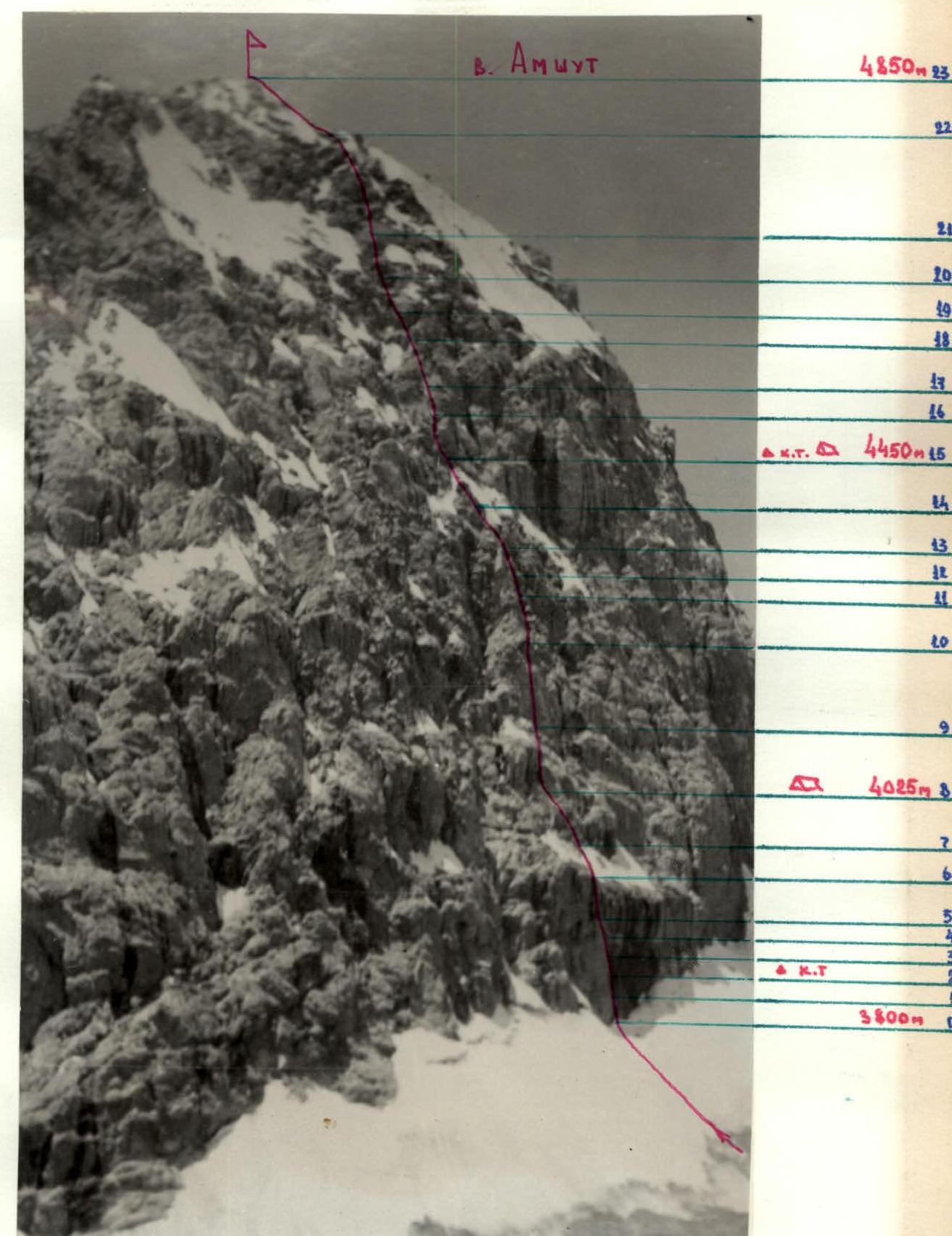
Profile of the Route to Peak Amshut via the Center of the North Wall
List of Equipment Taken on the Route (Traverse)
| № | Name of Equipment, Clothing | Quantity | Used on Sections / Applied | Total Weight |
|---|---|---|---|---|
| 1 | Main rope | 8x40 m | R0–R31 | 24 kg |
| 2 | Spare rope | 1x50 m | on descents | 1 kg |
| 3 | Titanium carabiners | 45 pieces | R0–R31 | 2.3 kg |
| 4 | Various titanium pitons | 40 pieces | R0–R31 | 1.5 kg |
| 5 | Titanium ice screws | 10 pieces | R24–R28 | 0.7 kg |
| 6 | Chocks | 20 pieces | R0–R31 | 1 kg |
| 7 | Nylon extension loops | 10 pieces | R0–R31 | 0.5 kg |
| 8 | Lightweight tent | 2 pieces | on bivouacs | 3 kg |
| 9 | Rock hammers | 3 pieces | R0–R31 | 1.2 kg |
| 10 | Ice axes | 1 piece | R24–R28 | 0.8 kg |
| 11 | Down sleeping bag | 1 piece | on bivouacs | 2 kg |
| 12 | Lightweight down jackets | 8 pieces | on the route | 8 kg |
| 13 | Down "leg" sleeping bags | 4 pieces | on bivouacs | 3.2 kg |
| 14 | "Ovel'" stove | 2 pieces | on bivouacs | 1 kg |
| 15 | Fuel | 3 liters | on bivouacs | 2.4 kg |
| 16 | Helmets | 8 pieces | R0–R31 | 3.2 kg |
| 17 | Personal gear | 8 sets | R0–R31 | 12 kg |
| 18 | "Vitalka" radio station | 1 piece | for radio communication | 0.5 kg |
| 19 | Homemade backpacks | 8 pieces | R0–R31 | 3.2 kg |
| 20 | Titanium crampons | 2 pairs | R24–R28 | 0.6 kg |
| 21 | Various ladders | 4 | R0–R23 | 0.4 kg |
| 22 | First aid kit | 1 set | 1 kg | |
| Total weight | 73.5 kg |
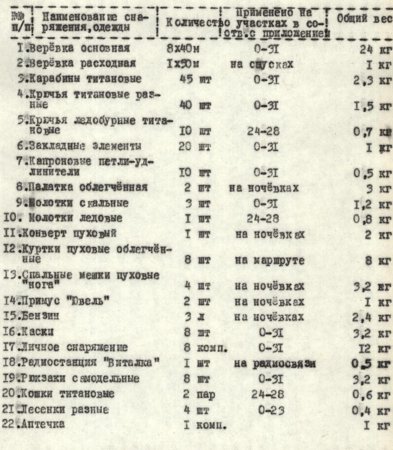
Table of Main Characteristics of the Route-Traverse of Peaks Amshut, Moscow, Sakharnaia golova with Ascent via the Center of the North Wall
| Date | Designation | Average Steepness in ° | Length in m | Relief Character | Difficulty | Condition | Rock Pitons | Chock Pitons | Ice Pitons | Time of Departure and Bivouac Setup |
|---|---|---|---|---|---|---|---|---|---|---|
| 26.07 | R0–R1 | 85 | 30 | wall with crack | 6 | monolithic | 10 | 3 | 4 | Departure – 5:00 |
| R1–R2 | 90 | 30 | internal corner | 6 | monolithic | 3 | 4 | 6 | 2 | |
| R2–R3 | 65 | 20 | wall | 6 | monolithic | 6 | 1 | 1 | ||
| R3–R4 | 85 | 20 | wall with ledge | 6 | monolithic | 9 | 3 | |||
| R4–R5 | 85 | 20 | wall | 6 | monolithic | 7 | 2 | |||
| R5–R6 | 85 | 40 | wall | 6 | monolithic | 11 | 2 | 4 | 1 Stop.–18:00 | |
| R6–R7 | 45 | 30 | slope | 4 | firn | 2 | Working hours – 13. | |||
| R7–R8 | 60 | 70 | wall | 5 | destroyed | 6 | Bivouac good, semi-reclining. | |||
| 27.07 | R8–R9 | 65 | 45 | wall | 5 | monolithic | 12 | 7 | ||
| R9–R10 | 80 | 40 | wall, cornice | 6 | monolithic | 8 | 6 | 1 | ||
| R10–R11 | 65 | 95 | wall | 5 | destroyed | 10 | 8 | |||
| R11–R12 | 75 | 90 | internal corner | 5 | monolithic | 12 | 12 | Departure – 7:00 | ||
| R12–R13 | 80 | 30 | wall, cornice | 6 | destroyed | 10 | 10 | Stop.–20:00 | ||
| R13–R14 | 70 | 70 | wall, edge | 5 | destroyed | 8 | 6 | Working hours – 13. | ||
| R14–R15 | 70 | 90 | wall, internal corner | 5 | monolithic | 6 | 7 | Bivouac good, reclining. | ||
| 28.07 | R15–R16 | 70 | 100 | wall | 5 | destroyed | 12 | 4 | ||
| R16–R17 | 80 | 30 | internal corner | 6 | monolithic | 10 | 5 | |||
| R17–R18 | 70 | 60 | wall | 5 | monolithic | 8 | 7 | |||
| R18–R19 | 60 | 50 | slope | 5 | firn, ice | 4 | 2 | |||
| R19–R20 | 80 | 20 | wall | 6 | monolithic | 6 | 7 | |||
| R20–R21 | 70 | 50 | wall | 5 | monolithic | 5 | 2 | |||
| R21–R22 | 60 | 50 | wall | 5 | destroyed | 12 | 14 | Departure from bivouac – 7:00 | ||
| R22–R23 | 50 | 40 | ridge | 3 | destroyed | 12 | 14 | Arrival on peak Amshut – 16:00 | ||
| R23–R24 | 50 | 500 | ridge | 4 | destroyed | 8 | Stop.–20:30 | |||
| Working hours – 13. | ||||||||||
| 29.07 | R24–R25 | 45 | 50 | slope | 4 | ice | 4 | |||
| R25–R26 | 20 | 400 | slope | 2 | firn | Departure – 8:00 | ||||
| R26–R27 | 40 | 200 | slope | 3 | ice | 2 | ||||
| R27–R28 | 45 | 60 | slope | 4 | ice | 8 | ||||
| R28–R29 | 30 | 400 | ridge | 2 | snow | Arrival on peak Moscow – 12:00 | ||||
| R29–R30 | 50 | 800 | ridge | 4 | destroyed | 6 | Stop.–17:00 | |||
| Working hours – 8. | ||||||||||
| 30.07 | R30–R31 | 55 | 600 | ridge | 4–5 | monolithic | 14 | 5 | Arrival on peak Sakharnaia golova – 11:00 | |
| Descent via the ascent route. | ||||||||||
| Departure on the route – 7:00. | ||||||||||
| Working hours – 7, including descent. |
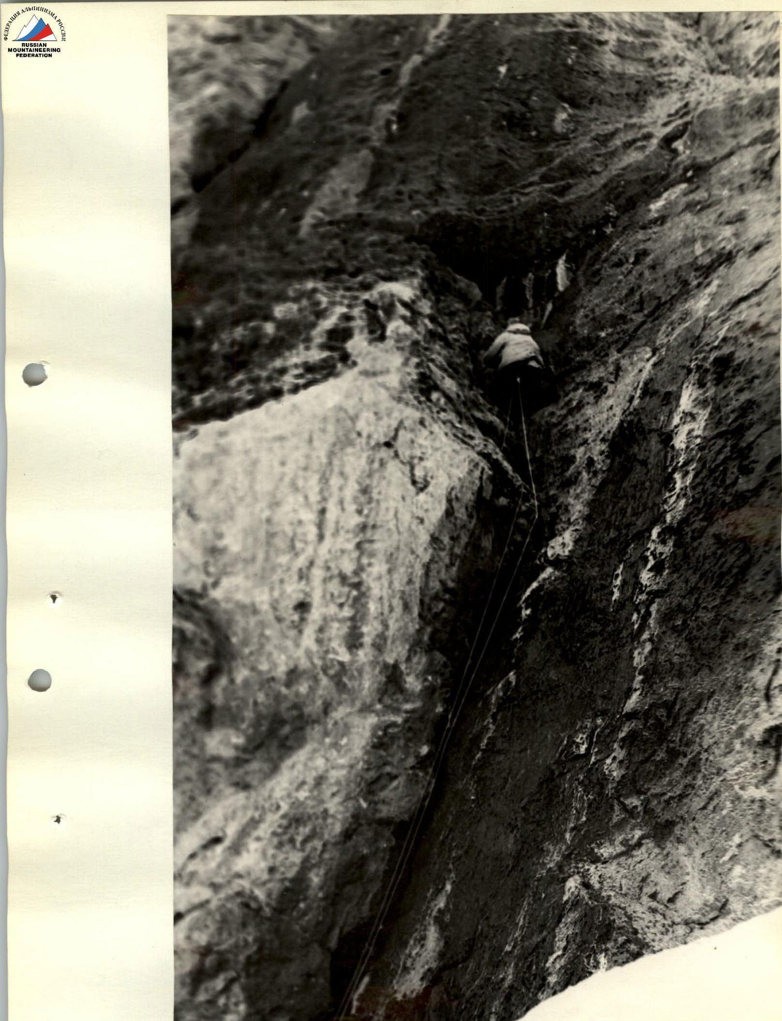
Second half of section R0–R1. Exit under the cornice.
PASSAGE OF SECTION R5–R6