Ascent Passport
- Ascent class: rock
- Ascent area: Pamir-Alay, Zeravshan Range, Fann Mountains
- Peak, its height, and ascent route: peak Alaudin (4237 m) via the southern counterfort.
- Estimated difficulty category: 3–6
- Route characteristics: height difference – 800 m; average steepness – 60°; section lengths: I – 110 m; II – 285 m; III – 240 m; IV – 55 m; V – 17 m; VI – 0 m.
- Pitons driven: for belaying for creating intermediate anchors rock – 22, ice – 0, bolt – 0
- Number of climbing hours: 7 hours.
- Number of nights and their characteristics: —
- Surname, name, patronymic of the leader and participants, their sports qualification:
-
- Zhitnyy Evgeniy Vasil'evich – 1st sports category (leader)
-
- Fesenko Aleksandr Ivanovich – 1st sports category
-
- Makoviy Vladimir Grigor'evich – 2nd sports category
-
- Epel'baum Anatoliy Grigor'evich – 1st sports category
-
- Bondarenko Nikolay Vladimirovich – 1st sports category.
-
- Team coach: Stadnik Vladimir Fedorovich – Candidate Master of Sports.
- Date of departure and return: July 4, 1979
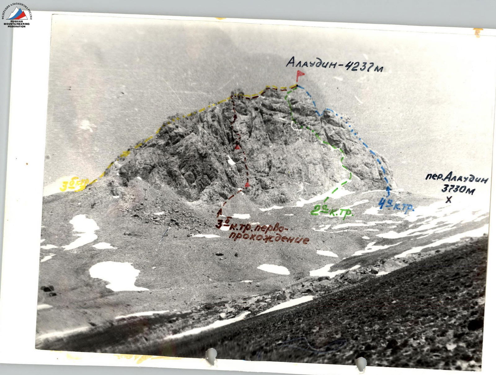
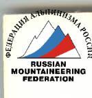
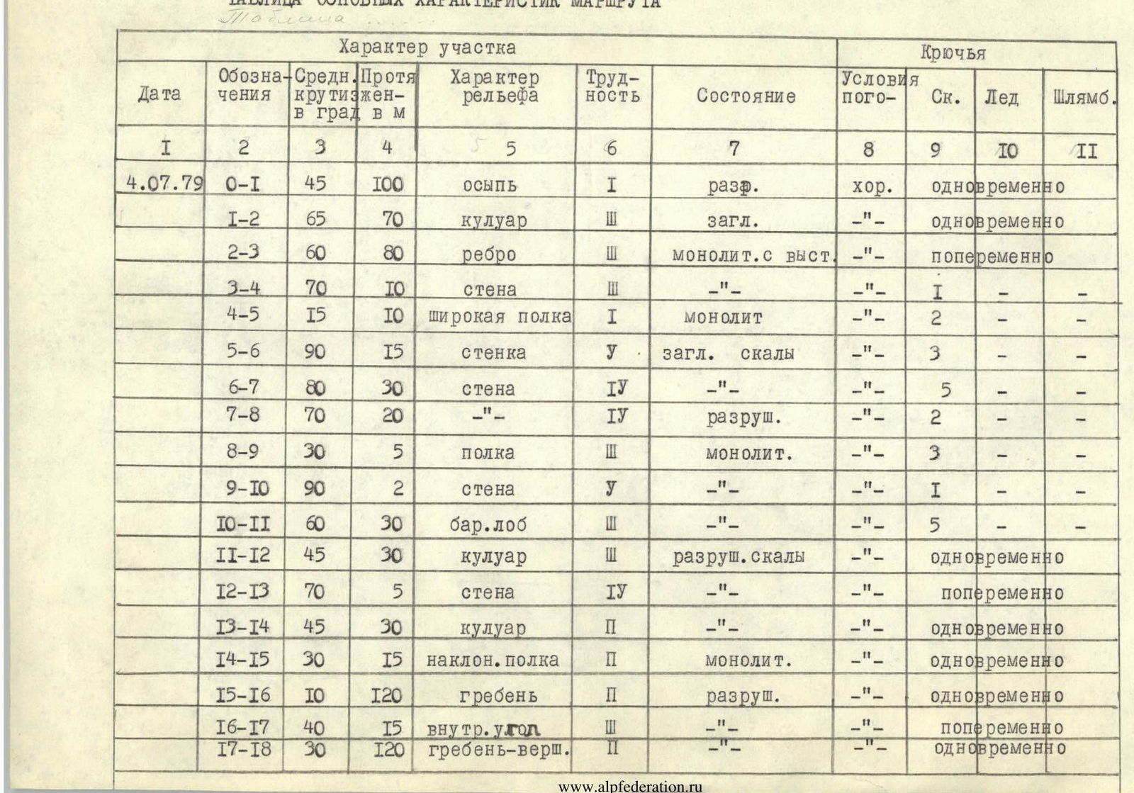
TABLE OF MAIN ROUTE CHARACTERISTICS
| Designation | Average steepness in degrees | Length in m | Terrain character | Difficulty | Condition | Weather conditions | Rock Pitons | Ice Pitons | Bolt Pitons |
|---|---|---|---|---|---|---|---|---|---|
| 4.07.1979 R0–R1 | 45° | 100 | scree | 1 | destroyed | good | simultaneous | – | – |
| R1–R2 | 65° | 70 | couloir | 3 | smooth | – | simultaneous | – | – |
| R2–R3 | 60° | 80 | edge | 3 | monolithic with ledges | – | alternating | – | – |
| R3–R4 | 70° | 10 | wall | 1 | – | – | 1 | – | – |
| R4–R5 | 15° | 10 | wide ledge | 1 | monolithic | – | 2 | – | – |
| R5–R6 | 90° | 15 | wall | 5 | smooth rocks | – | 3 | – | – |
| R6–R7 | 80° | 30 | wall | 4 | – | – | 5 | – | – |
| R7–R8 | 70° | 20 | – | 4 | destroyed | – | 2 | – | – |
| R8–R9 | 30° | 5 | ledge | 3 | monolithic | – | 3 | – | – |
| R9–R10 | 90° | 2 | wall | 5 | – | – | 1 | – | – |
| R10–R11 | 60° | 30 | "ram's foreheads" | 3 | – | – | 5 | – | – |
| R11–R12 | 45° | 30 | couloir | 3 | destroyed rocks | – | simultaneous | – | |
| R12–R13 | 70° | 5 | wall | 4 | – | – | alternating | – | |
| R13–R14 | 45° | 30 | couloir | 2 | – | – | simultaneous | – | |
| R14–R15 | 30° | 15 | inclined ledge | 2 | monolithic | – | simultaneous | – | |
| R15–R16 | 10° | 120 | ridge | 2 | destroyed | – | simultaneous | – | |
| R16–R17 | 40° | 15 | internal corner | 3 | – | – | alternating | – | |
| R17–R18 | 30° | 120 | ridge-summit | 3 | – | – | simultaneous | – |
 EXPLANATION OF THE TABLE
The start of the route is to the left of the counterfort, where a scree cone is visible, and along it, pressing against the rocks on the left along the way and traversing to the right in the upper part, exit to the shoulder (R0–R1). The 1st control cairn is located on the platform. Further up along the wide couloir with smoothed rocks, exit to the edge, which will lead to the left part of the wall of the southern counterfort (R1–R2; R2–R3; R3–R4). The 2nd control cairn is located on the ledge under the wall (R4–R5). Via an oblique crack with an overhang to the right and upwards, exit to smoothed rocks (R5–R6). Key location. Piton belay! Possible assistance. Further traverse to the left along complex rocks (R6–R7). Then up and to the left, and along an inclined ledge, exit under a 2-meter wall (R7–R8; R8–R9). The wall is overcome directly (R9–R10). Further ascent along rocks like "ram's foreheads" to the right and upwards in the direction of the gate formed by two gendarmes (R10–R11; R11–R12). Overcoming a 5-meter wall, exit into a destroyed couloir (R12–R13; R13–R14). The couloir leads under a rock tower, which is bypassed on the left (R14–R15). Further along the destroyed ridge, overcoming несложных rocks, exit to the summit (R15–R16; R16–R17; R17–R18). Descent via route 2A category of difficulty.