PASSPORT
I. Technical class 2. Pamir-Alay, Zeravshan ridge 3. p. Adam-Tash, 4700 m, via N face, E edge 4. 5B cat. dif., third ascent 5. Route characteristics: elevation gain 630 m, length 980 m, sections of 5-6 cat. dif. 380 m average steepness of the main part of the route 75° 6. Pitons used: rock 10/3 bolts 3/2 chocks 130/9 7. Climbing hours: 17 h, days 2 8. Overnight bivouac, in bivouac bags 9. Participants: Kuznetsov Alexander Vladimirovich CMS; Pavelyev Anatoly Nikolaevich CMS 10. Coach: Zakharov Nikolai Nikolaevich II. Departure to the route: August 1, 1986 summit: August 2, 1986 return: August 2, 1986 12. Sports club "Yenisei"
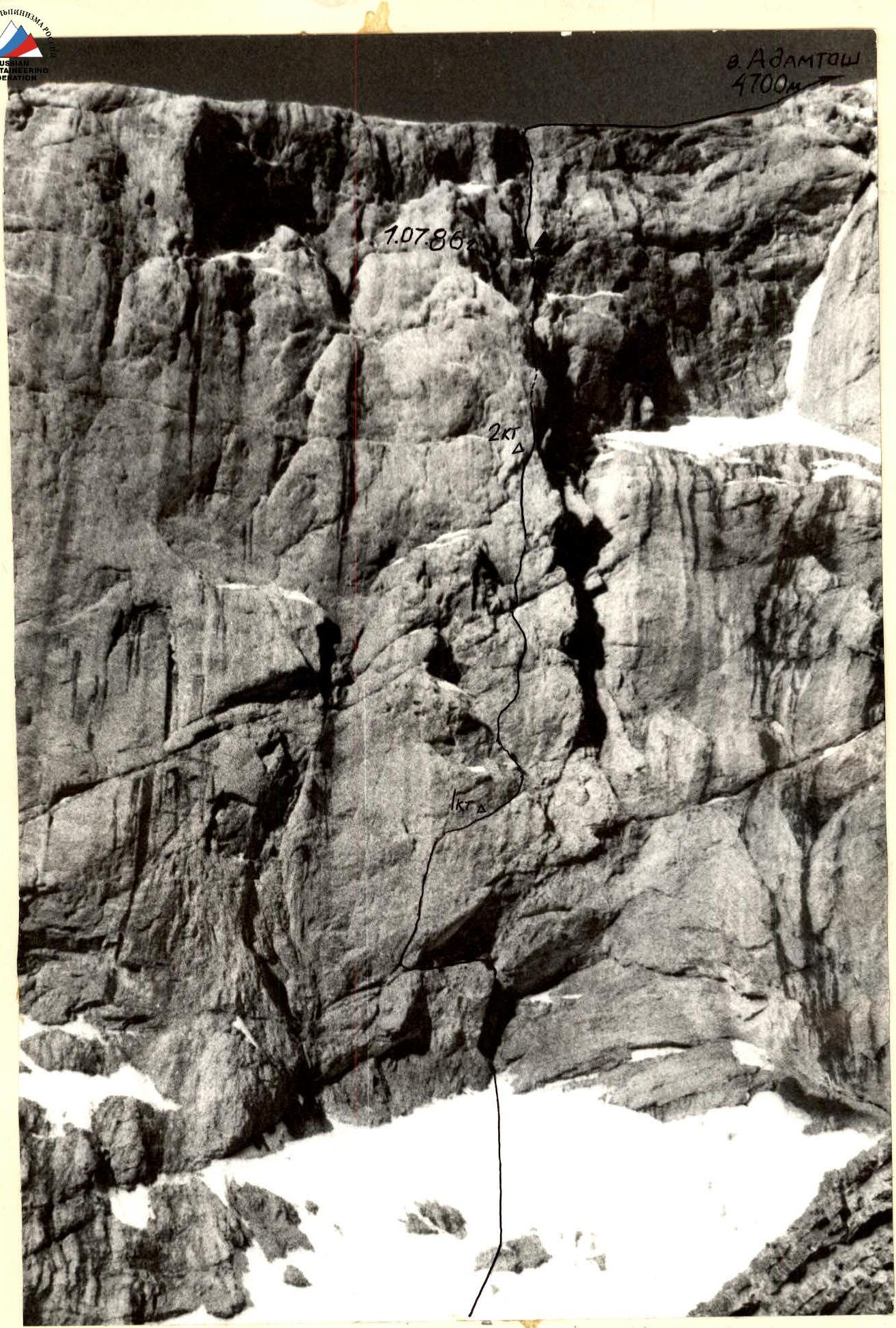
General photo of the summit. Taken on June 30, 1986 at 17:00. "Industar" lens, Φ = 50 mm. Distance 600 m.
BRIEF DESCRIPTION OF THE ROUTE BY SECTIONS
R0–R1. Inner corner, heavily destroyed. R1–R2. Traverse up left on a vertical wall, approach to the crevice through an overhang. R2–R3. Crevice in a vertical wall, monolith. "Friends" and large chocks are used. R3–R4. Traverse right on an inclined ledge. R4–R5. Wall, left face of the buttress. R5–R6. Ridge, left face, monolith. R6–R7. Transition to an inner corner, then up the corner, rocks are destroyed, icy, exit to a snowy ledge under overhanging rocks. R7–R8. Vertical wall with an overhang, monolith. R8–R9. Wall, moving up left towards a large inner corner. Snow, ice. R9–R10. Wall, ends in an inner corner, then a chimney. Ice, snow. Exit to scree fields. Further via route 4a
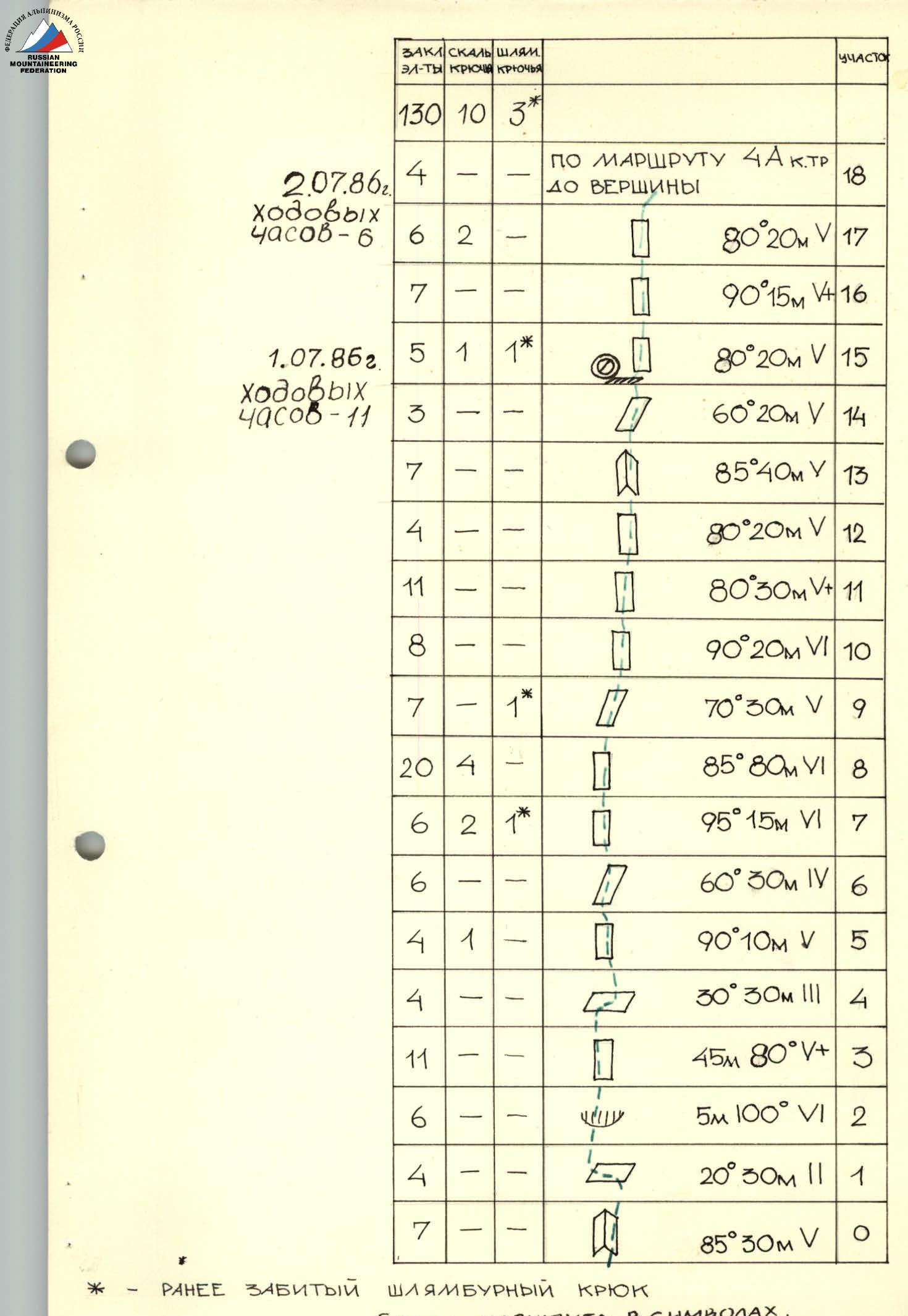
CHOCKS ROCK BOLTS EQUIPT PITONS SECTION 130 10 3* July 2, 1986, 6 climbing hours: 4 - - via route 4A cat. dif. R18 6 2 - 80° 20 m (5) R17 7 - - 90° 15 m (5+) R16 July 1, 1986, 11 climbing hours: 5 1 1* 80° 20 m (5) R15 3 - - 60° 20 m (5) R14 7 - - 85° 40 m (5) R13 4 - - 80° 20 m (5) R12 11 - - 80° 30 m (5+) R11 8 - - 90° 20 m (6) R10 7 - 1* 70° 30 m (5) R9 20 4 - 85° 80 m (6) R8 6 2 1* 95° 15 m (6) R7 6 - - 60° 30 m (4) R6 4 1 - 90° 10 m (5) R5 4 - - 30° 30 m (3) R4 11 - - 45 m 80° (5+) R3 6 - - 5 m 100° (6) R2 4 - - 20° 30 m (2) R1 7 - - 85° 30 m (5) R0
-
- PREVIOUSLY DRIVEN BOLT ROUTE SCHEME IN SYMBOLS.