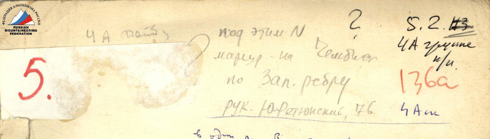
Report
on the first ascent to Peak "Chelyabinsk" via the eastern side, category 4A difficulty (approximate).
Group leader: Vyacheslav Savovich Marchenko — 1st sports category Participants: Gennadiy Georgievich Chavka — 1st sports category Alexander Ivanovich Savchenko — 1st sports category Vasily Konstantinovich Alexandrov — 1st sports category
Group coach: Mikhail Mikhailovich Zakhzhiy
The ascent was made on July 18, 1977.
Leningrad
1977
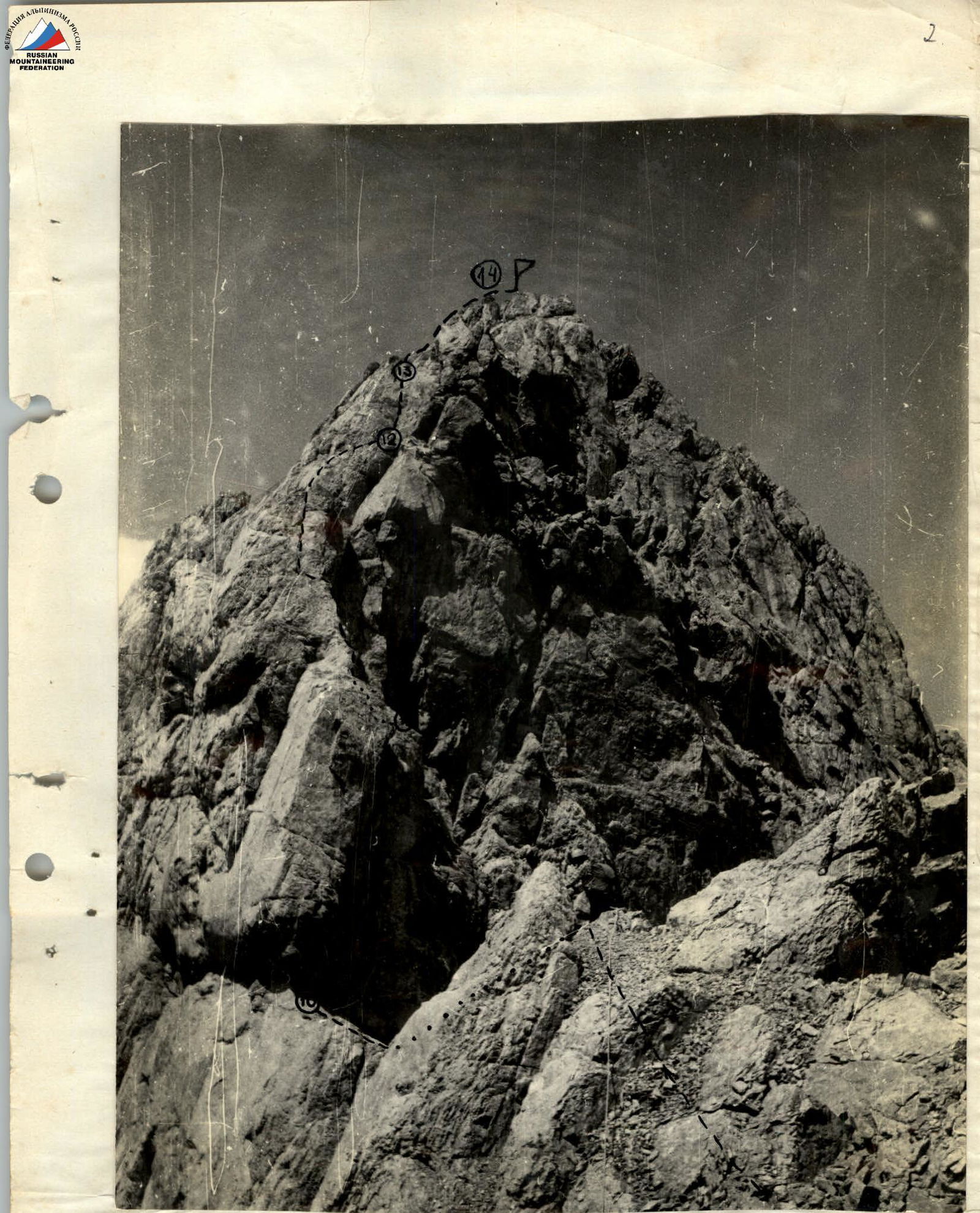
Ridge section R10–R13
Brief description of the approach to the route and explanations for Table I
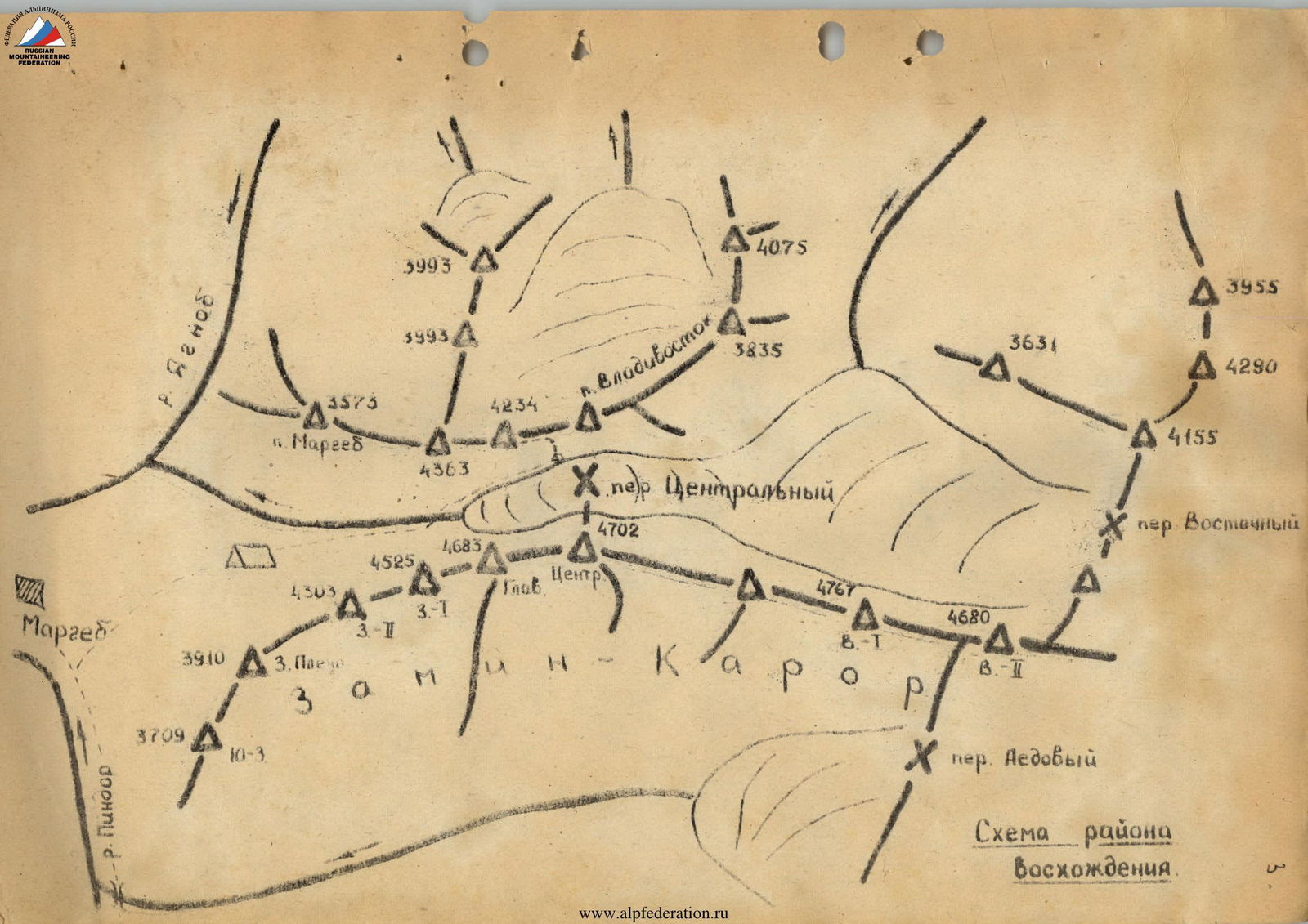
The ascent to the summit is made from a bivouac located below the Central Pass. From the base camp, ascend to the Central Pass along the stream, then along the moraine on the right (orographically) part of the glacier. A second path, recommended by climbers, goes to the left. This path is particularly preferable in the second half of summer when snow bridges over the stream melt. From the base camp, immediately cross the stream and ascend the steep grassy slope opposite the Yaghnob wall. Climb the slope to the saddle between two rocky towers. Then, along grassy ledges to the left of the rocky ridge and along the moraine, proceed to three large stones, 300–400 m short of the pass. The approach for the night takes about 3 hours.
From the night's stop, ascend directly up along the scree and snow towards the yellow overhanging rocks at the lower part of the counterfort.
The lower part of the route generally follows an inclined groove crossing wet slabs with trickles. At the top, the groove leads to an internal angle turning into a chimney.
Through simple, destroyed rocks, enter a wide inclined (section R0–R1) ledge below the yellow overhanging rocks. Traverse 15 m left along the ledge under a vertical crack. Then, 15 m up the crack to an inclined groove. Along the groove, crossing wet slabs for 80 m to the base of the internal angle (section R2–R3). Up the internal angle for 40 m to an inclined rock with smoothed walls (section R3–R4). Through a chimney for 20 m under overhangs (section R4–R5). Bypassing the overhangs to the right, exit into a couloir. Then, 60 m up the slabs on the right wall of the couloir to the left, exit onto a scree ledge. On the scree ledge, there's a control cairn (section R5–R6).
From the control cairn, ascend along slabs, a wide scree ledge, and destroyed rocks to an internal angle (section R6–R8). Up the left wall of the internal angle for 80 m to exit onto the ridge, 40 m to the right of the section.
Section R8–R9
its lowest point. Then, move left along the ridge through a gendarme to a vertical wall with a crack filled with pitons (400 m) (section R9–R10). On the ridge under the wall, there's a convenient area for setting up belay (section R10–R11). Up the crack directly for 20 m. Then, traverse right along a ledge to bypass an overhang. From the ledge, up and left along steep, destroyed rocks to exit onto the ridge before a rise (section R11–R12). Further, up an internal angle formed by smoothed slabs on the left side of the ridge, onto a ledge under a light-gray slab. Up the slab for 7 m and to the left to continue along the ridge.
Ascend along the ridge and heavily destroyed rocks to the shoulder. From here, through a slight depression in the ridge with two gendarmes, bypassed to the left, exit onto the summit. The summit is composed of dark-gray, heavily destroyed blocks (section R13–R14).
Descend via the ascent route. The group took 9 hours for the ascent. The descent took 6 hours.
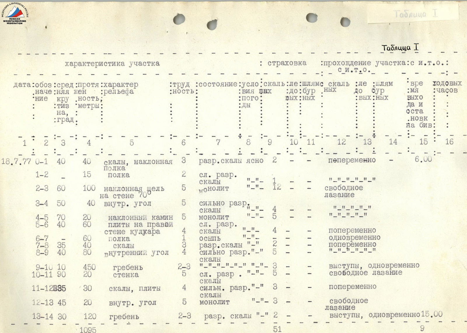
Table I
Characteristics of the section:
- belay
- passage of the section: with ITD (Intermediate Technical Difficulty)
- with ITD
Brief geographical description of the ascent area. Gissar Ridge.
The Gissar Ridge is an extensive latitudinal mountain system of significant height, connected to the east with the Alay Ridge, and primarily composed of granites and granodiorites. Typical for Pamir-Alay, there are also sections with a predominance of sedimentary rocks — limestones and marbles. They are marked by steeper walls.
The sufficiently developed modern glaciers of the Gissar Ridge are but a faint trace of the great glaciation that once covered the now-flourishing valleys with a cold carapace. The former size of the glaciers is silently testified to by the preserved terminal and ground moraines and the abundance of lateral spurs and ridges with deep gorges between them. The entire current ice cover of the Gissar Ridge, mainly located on the northern and western slopes, is in a state of retreat. The accumulation areas are mostly small, and the replenishment of glaciers occurs through avalanches and ice falls from summit domes and slopes. The climate here is analogous to that of the Fann Mountains: continental, with a small amount of precipitation annually (on average 250 mm). From July to the end of September, with rare deviations, there is stable sunny weather. Winds come here dried out and infrequently; relative calm is sometimes interrupted by the "Afghani" — a wind carrying dense reddish or gray haze and increased cloudiness. Thunderstorms are possible, usually not prolonged but with strong discharges (a known incident with climbers in 1969).
In October, cold winds and snowfalls begin. Winter conditions are harsh. Administratively, the vertices of interest are located on the territory of the Ayni district of the Leninabad region of the Tajik SSR.
Historical excursus
The development of the Zamin Karor massif began in 1969. L. Lapshin’s group made an ascent to the main summit via a category 2B route from the south. In the same year, V. Petrov’s group passed a category 4B route on the north wall to the Western shoulder. In 1970, L. Lapshin’s group completed a category 5B route on the northwest wall to the 2nd western summit. In 1971, on the Central summit via the north counterfort, a category 5B route was made by Akopdzhanyan's group. By the 1977 season, there were 12 classified routes on Zamin Karor.
Sports characteristics of the ascent object.
To the north of Zamin Karor, the ridge of the massif rises deeply, downwards from the "dugobi" — the confluence of the Yaghnob and Pindrr rivers. In the western part, the red peak "3753" rises, followed by "3 camels" — smooth, steep ascents — and, finally, a pillar-like ascent before the nodal summit of the northern massif — peak "4364" (Peak Chelyabinsk). Behind it, a even ridge through a slight elevation of the still unvisited peak "4234" leads to peak "Vladivostok", the first to be mastered in the northern massif. Here, the ridge sharply drops to the Central Pass (3750 m), compressed on the opposite side by the wall of Zamin Karor. The walls are composed of marmoreal limestones, местами сильно заглаженными. Zamin Karor faces north with sheer and overhanging monolithic rocks, and to the south with more sloping rocks. The rocky walls of the northern massif, on the contrary, are more gentle to the north and smooth and weakly dissected from the south.
To the north of Zamin Karor, the massif contains 4 distinctly expressed peaks: Peak Margeb (3573 m), Peak Chelyabinsk (4363 m), peak "4234 m", and Peak Vladivostok (4257 m). By the 1977 season, routes were classified: category 2B on Peak Margeb, category 4B via the Western ridge on Peak Chelyabinsk, and category 3B from the South on Peak Vladivostok.
Until the summer of 1977, the paths to Peak Vladivostok via the South wall and East ridge, and the traverse of the peaks Margeb – Chelyabinsk – "4234" – Vladivostok remained unattempted. We chose the unattempted eastern ridge to peak "4234" with an exit to the ridge via the South wall for the ascent. The route is purely rock. The rocks on the wall section are monolithic, pleasant for climbing. There are cracks and grooves allowing for reliable piton belays. The eastern ridge leading to the summit is heavily destroyed. To the south, the ridge drops with sheer walls in the form of monolithic smoothed slabs (average steepness 70–80°). The northern slopes are more destroyed. Individual sections of the northern slope are covered with snow. The first half of the route is a pure wall ascent (length 350–400 m, average steepness 60–70°). The steepness of the second half decreases sharply. The path is purely ridge-like. On the ridge, several gendarmes are encountered, which are passed head-on. When passing one of the gendarmes, a wall with a steepness of 90° (20 m) is encountered. The pre-summit part of the ridge is a jumble of destroyed rock blocks, passed with medium-difficulty climbing.
Despite the fact that the second half of the route does not present significant technical difficulty overall, the abundance of technically complex sections on the first wall half and the overall length of the route allow us to conclude that the route is not weaker than analogous category 4A routes (for example, in comparison with the route to R0–R3 shoulder of Zamin-Karor via R10–R3 ridge, category 4A).
This gives grounds to assume that the route passed may correspond to category 4A.
Group preparation
The group arrived in the Yaghnob area as part of a gathering of the Leningrad regional council of the "Burevestnik" sports society. A significant pre-camp preparation preceded the summer season in the mountains.
The autumn-winter period included general camp preparation: cross-country runs, ski races. In spring and summer, at rock gatherings, group participants underwent special rock climbing preparation. In the Yaghnob area, active acclimatization, rock, snow, and ice training were conducted, and training and sports ascents of categories 4–5 were made.
Documents and photographic materials were obtained at the "Varzob" alpine camp. The group leader and participants, before making the first ascent, repeatedly ascended to the Central Pass and made an ascent to Peak Vladivostok via a category 3B route.
List of group participants:
| № | Surname, Name, Patronymic | Year of birth | Sports qualification | Home address |
|---|---|---|---|---|
| 1 | Marchenko Vyacheslav Savovich | 1951 | 1st sports category | 188510, Lomonosov, Leningrad region, Krasnogo Flota st., 16–31 |
| 2 | Chavka Gennadiy Georgievich | 1942 | 1st sports category | Leningrad, Nekrasovskiy pr., 422, apt. 19 |
| 3 | Savchenko Alexander Ivanovich | 1952 | 1st sports category | Leningrad, Nevsky pr., 27/18, apt. 18 |
| 4 | Alexandrov Vasily Konstantinovich | 1951 | 1st sports category | Leningrad, Varshavskaya st., 22, apt. 69 |