Ascent Passport
- ASCENT CLASS — rock climbing
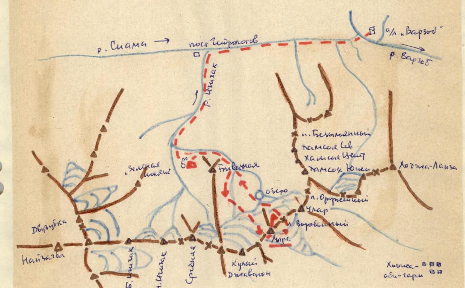
- ASCENT REGION — Pamir-Alay, Igizak area
- PEAK, ASCENT ROUTE — Hyrс, via the cleft in the western wall buttress
- EXPECTED DIFFICULTY CATEGORY — 3B–4B
- ROUTE CHARACTERISTICS: 1000 m elevation gain, ice and rock, main section is rock with an average steepness of 75° and a length of 200 m, 4th difficulty category.
- 15 rock pitons hammered in for belaying
- MOVING TIME — 8 hours for a team of two
- NUMBER OF NIGHTS —
- PARTICIPANTS' FULL NAMES — Kadmensky A.G. (1st sports category), Furman V.I. (Candidate for Master of Sports)
- DATE — August 25, 1978
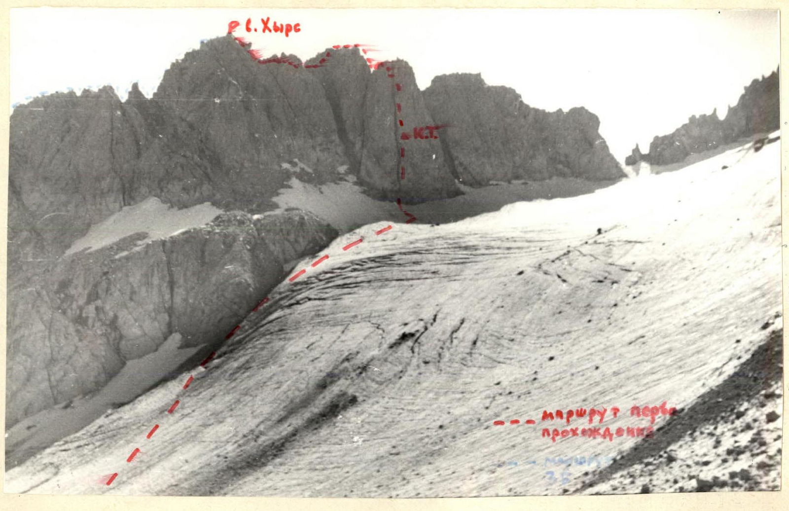
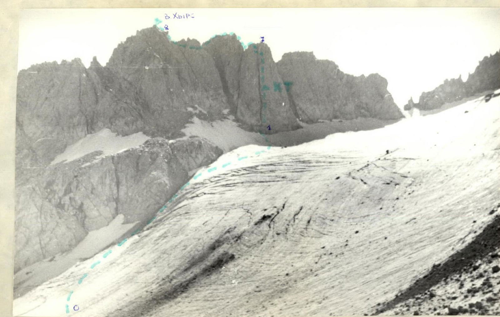
Peak Hyrс from the west from the Kulay-Javanon glacier cirque
Characteristics of the Climbing Area and Object
Peak Hyrс is located in the southwestern spurs of the Gissar Range. The first ascent route was laid along the western buttress of Hyrс from the Kulay-Javanon glacier. At the time of the ascent, the route was primarily rock climbing. However, at the beginning of summer, the key section of the route — the cleft in the wall of the 3rd buttress — may be partially filled with ice.
Area Map and Diagram
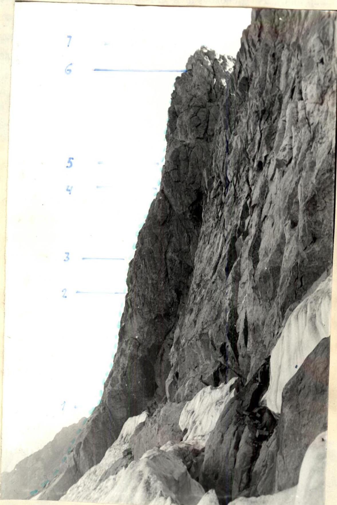 Profile of the Western buttress of Hyrс
Route Description by Sections
Section R0–R1. (see Table of Main Route Characteristics)
From the lake under the Kulay-Javanon glacier, ascend left along the snowfield under the slopes of Hyrс and then along the boundary between rocks and ice to the upper terrace of the glacier. Along the glacier in the direction of the western buttress adjacent to the northern sub-summit ridge of Hyrс (see photo and route diagram). A characteristic trough-shaped gap in the ridge, from which a wide black streak descends, remains to the right. Cross from the glacier to the rocks (destroyed, loose stones) at the base of the buttress via a bridge and ascend to a wide ledge. From the ledge, ascend vertically up a cleft 1.5–2 m wide that splits the wall of the western buttress of Hyrс.
Section R1–R2. The first 50 m are traversed along the steep edges of the cleft. There are sufficient holds, and camming and friction are widely used.
Section R2–R4. The next 10 m, where the steepness of the cleft increases (in places — slight overhanging), are traversed "head-on." Twenty meters higher, in the left wall of the cleft, there is a control cairn in a tin can on a piton. Belaying is piton-based, and it is convenient to jam oneself in the cleft while belaying. Above the cairn (20 m), a second overhanging section (section R4–R5) about 10 m long is visible in the form of a characteristic tooth against the sky. It is traversed "head-on."
Section R5–R6. Twenty meters up — a ledge. Here the cleft ends in a small rock cirque where one can stand and gather one's wits. Be cautious — loose stones pose a danger to climbers below.
Section R6–R7. From the ledge, ascend left up and right along a steep wall (10 m) and then left up onto a rocky ridge (20 m). Belaying is piton-based. The total height of the wall section of the buttress is about 200 m with an average steepness of 75°.
Section R7–R8. Along the ridge, descend left to a saddle (20 m). The first "mandarin" (sub-summit) is traversed "head-on" (40 m) over large boulders, from which descend left onto ledges that follow the left (in the direction of travel) side of the ridge and lead into a gap under the summit tower. Ascend onto the tower — one rope length. The summit. The path from the lake took the team about 4.5 hours.
The most convenient descent option is to return to the saddle in the ridge before the sub-summit and descend left (in the direction of travel) down a simple scree gully. Then, under the slopes of Hyrс, descend to Vorobьиный pass. Thus, the route from the bivouac under Biвуачная peak took the team 7.5 hours.
GEAR FOR A TEAM OF TWO
| 1. Main rope | 50 m |
|---|---|
| 2. Rock pitons | 10 pcs |
| (thin and channel) | |
| 3. Hammers | 2 pcs |
| 4. Carabiners | 10 pcs |
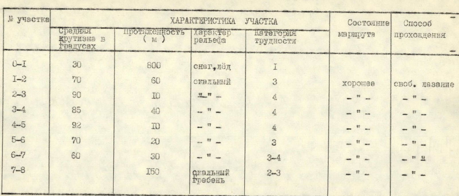
Table of Main Route Characteristics
| Section | Average Steepness in Degrees | Length (m) | Terrain Type | Difficulty Category | Route Condition | Climbing Method |
|---|---|---|---|---|---|---|
| R0–R1 | 30 | 800 | snow, ice | 1 | ||
| R1–R2 | 70 | 60 | rock | 3 | good | free climbing |
| R2–R3 | 90 | 10 | " | 4 | " | — |
| R3–R4 | 85 | 40 | " | 4 | " | — |
| R4–R5 | 92 | 10 | " | 4 | — | " |
| R5–R6 | 70 | 20 | " | 3 | " | — |
| R6–R7 | 60 | 30 | " | 3–4 | — | " |
| R7–R8 | 150 | rocky Ridge | 2–3 | — | " |