
Ascent Record
- Ascent type — rock climbing.
- Ascent area — Igizaki, Gissar Ridge.
- Peak — Khyrс, 3760 m, from Kulay Djavanom glacier via the shortest route.
- Estimated difficulty category — 2B.
- Route characteristics: elevation gain — 350 m, average steepness — 65°.
- Number of pitons driven — 17, number of chocks — 9.
- Total climbing hours:
- approach from "Zelyonaya Polyana" bivouac — 2–2.5 hours,
- ascent to the summit — 3 hours,
- descent from the summit to "Zelyonaya Polyana" bivouac — 2.5 hours.
- Overnight stay possible on the ridge.
- Ascent made by a team of two instructors: Igolkin V.I., Candidate for Master of Sports, 455000 Magnitogorsk, ul. Mamina 37–18. Kudryashov V.S., Candidate for Master of Sports.
- Departure from "Zelyonaya Polyana" bivouac — June 27, 1981, return on the same day.
Table of main characteristics of the first ascent route to Khyrс peak from Kulay Djavanom glacier via the shortest route, 2B category.
| Date | Section characteristics | Weather conditions | Notes | |||||||
|---|---|---|---|---|---|---|---|---|---|---|
| section designation | Average steepness | Length | Terrain characteristics | Difficulty | Condition | Variable cloudiness, occasional rain, +5…+10° | Rock pitons | Chocks | ||
| June 27, 1981 | R0–R1 | 60° | 90 m | Firn slope | 2 | Firm, местами | via ice axe | In the middle of R2–R3 section, a control tour | ||
| R1–R2 | 75° | 40 m | Internal corners, walls | 3 | Monolithic — « — » | 4 | 2 | |||
| R2–R3 | 75° | 40 m | 3 | — « — » slightly damaged | 4 | 3 | ||||
| R3–R4 | 65° | 80 m | 2 | 4 | 2 | |||||
| R4–R5 descent | 60° | 70 m | Walls, internal corners on the ridge | 2 | -"- | 1 | 2 |
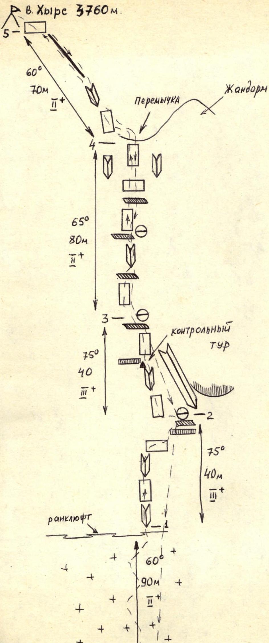 Ascent route diagram to Khyrс peak, 3760 m.
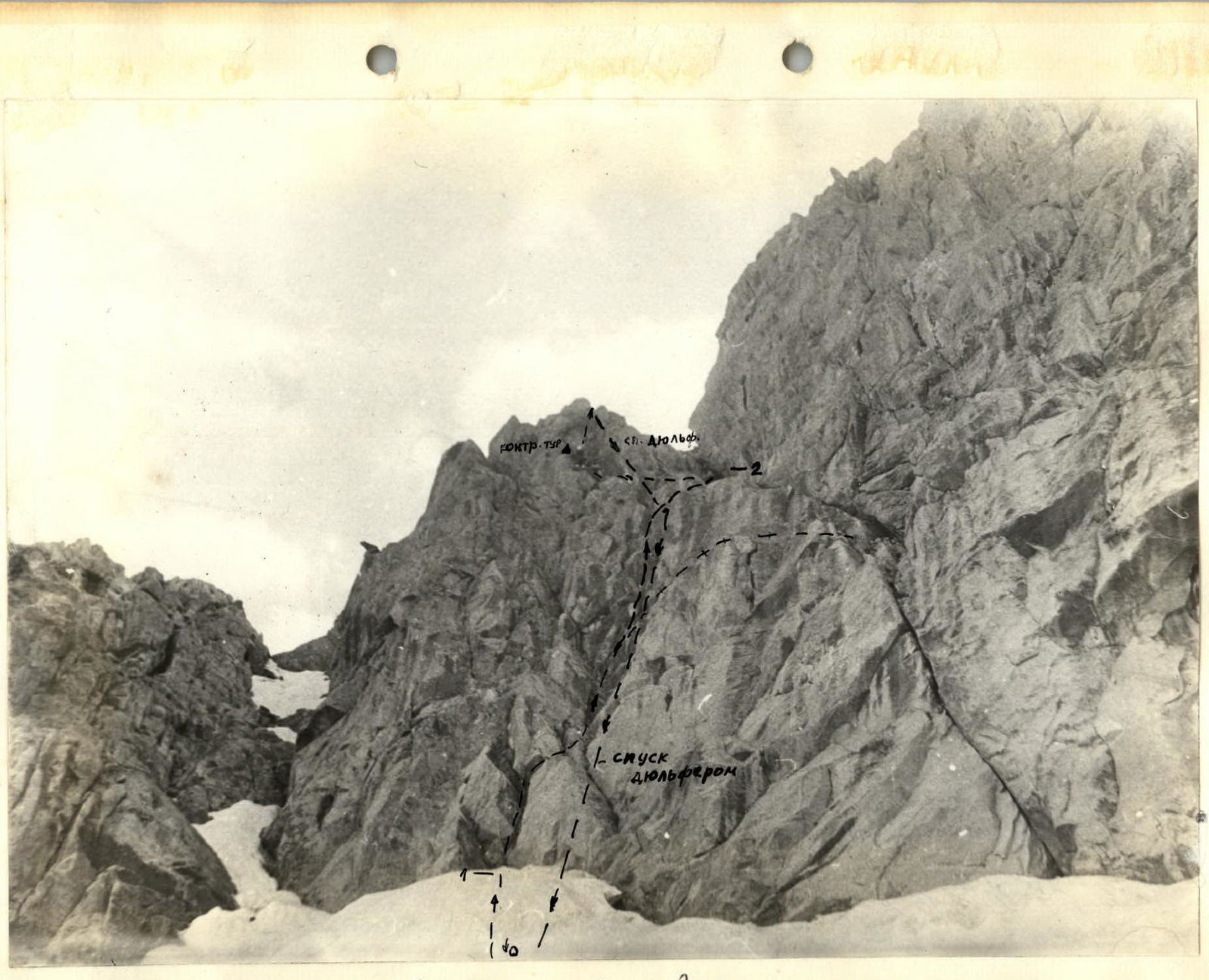
Photo 2. Start of the route. A climber is seen near the control tour.
Route Description
From "Zelyonaya Polyana" bivouac, go upstream along the stream flowing from the left cirque to the old moraine of Ular glacier. Then turn right into the cirque of Kulay Djavanom glacier. Approaching the steep western slope of the glacier, descending from the saddle between Khurs peak and Maly Kulay Djavanom peak, ascend this slope to reach the foot of the Western wall of Khyrс peak.
The massif of Khyrс peak is a narrow ridge, 1 km long, stretching from north (from Vorobьиный pass) to south (saddle between Maly Kulay Djavanom peak). There are routes to the summit:
- 3A category via Vorobьиный pass;
- via the Western wall, 3B category, to a gendarme south of the summit, and then along the ridge to the summit.
A new route, estimated as 2B category, is proposed via the Western wall from Kulay Djavanom glacier cirque by the shortest path, leading directly to the summit.
On the Western wall, the route is located as follows. Khyrс peak is not prominent from Kulay Djavanom glacier, so it's necessary to approach the Western wall and find a characteristic 3B category route (via a crack between two black sheer couloirs). 40–50 m to the left of the left black couloir, a slanting crack (from right to left) crosses the entire wall. The route starts 10–15 m to the left of this crack.
Section R0–R1. Ascend a firm firn slope for 90 m; the second half of the section is an ice slope covered with a thin (5–10 cm) layer of firn.
- In the middle of the slope, there is a covered crevasse.
- The slope ends with a rancleuft 1–1.5 m wide, with small bridges leading to the wall rocks.
- A challenging transition to the rocks.
Section R1–R2. After crossing the rancleuft, exit onto monolithic, weakly fractured, and smoothed rocks. The start is challenging due to difficulties in organizing intermediate belays. By the end of summer, the firn may melt 3–5 m below, further complicating the start of the route.
Begin ascending via an internal corner. After 15–20 m, the rocks become more pronounced, with more cracks for belaying.
Ascend another 6–7 m vertically to a sheer wall:
- move right with a 6–7 m ascent through a steep outcrop overhanging the wall, first reaching a small ledge (with pitons and a rappel loop);
- then ascend right-upwards for 6 m to a good ledge under the overhanging right wall, where belaying is possible from a rock outcrop in a crack.
Section R2–R3. Traverse left along the ledge for 3 m, behind a wall outcrop, and then ascend a smooth slab for 12 m to reach a sheer internal corner. Ascend the corner for 7 m to a small overhang. Here, on a piton, is a control tour. The overhang is passed on the right via an internal corner. Then, ascend a sheer wall for 5 m to exit onto a ledge. Further, ascend via small walls to outcrops, where belaying is possible.
Section R3–R4. Move upwards, choosing the simplest terrain sections in the direction of the saddle between a gendarme on the right and the summit tower on the left. The terrain includes sheer walls alternating with ledges and internal corners. The rocks are slightly damaged, with some loose stones. The length to the saddle is 80 m. Before the saddle, there is a 6 m sheer wall. It is passed on the left.
Section R4–R5. Ascend along the ridge with varied terrain and monolithic rocks for 70 m to reach Khyrс peak.
Descent is possible via the ascent route (requiring 5–6 pitons) or via traditional routes: through the southeast slope and Vorobьиный pass or through the saddle between Khyrс peak's ridge and Maly Kulay Djavanom peak.
The route is challenging for 2B category but has a relatively short length. It is recommended as a training route for sports teams. In relatively good weather, the first ascenders (a team of two instructors) took 3 hours to ascend and 1.5 hours to descend via the ascent route. The approach to the route from "Zelyonaya Polyana" bivouac takes 2–2.5 hours. The route is recommended to be climbed in good weather.