Description
OF THE ASCENT ROUTE TO THE SUMMIT OF KHODZHA-LOKAN /"MECHTA", 4767/ VIA THE SOUTH-EAST RIDGE.
Dushanbe 1962
If you fly from Dushanbe to Moscow and the plane goes directly north, not through the Baysun pass, you can see this mountain.
Soon after takeoff, the southern folds of the Hissar range appear below. The Varzob River is under the plane. Dark gray rocks line the stream's banks. Higher up, mountains rise. Among the rocks, patches of snow appear. Ice... To the left, a tall, slender mountain on an icy pedestal emerges. Like the surrounding lower peaks, it is mostly dark gray, but stands out from its neighbors with its elegance and the fact that a huge bluish snow-ice "cushion" is "hanging" on its northeastern side, clinging to its "tip".
Climbers call this mountain Mechta...
In 1897, while traveling through the Pamir-Alay and reaching the upper reaches of the Khanaka River, Academician LIPSKY V.I. saw this peak and made the following note: "From the pass ... a high snowy ridge was visible, much higher than the one we were on... The main peak of this ridge, significantly rising above the ridge, is conical..., sharply distinguished by its height". (LIPSKY V.I. "Mountain Bukhara. Results of three years of travel in Central Asia in 1897-1899." St. Petersburg, 1902, part 1, p. 126).
This area began to attract the attention of mountaineers as the alpinism exploration of the Pamir-Alay began, particularly after the establishment of the Varzob alpine camp.
In June 1953, during one of the reconnaissance hikes, a group from the alpine camp ascended to the summit of Bakhubi (Udal'naya-Tadj.), located on the watershed of the Sioma and Maykhura rivers. A participant in this ascent, now an alpinism instructor A.G. SHUKUROV, recounts that, looking at the panorama that opened up from the summit, with a beautiful pyramid in the center, the group leader A.A. KUZNETSOV exclaimed, "This is a dream!"
The word "Mechta" became the temporary, conditional name for the peak. Soon, this name became so established that the new peak was referred to by no other name. Only at the end of 1957, when climbers managed to find a detailed map, it turned out that the peak had long had its "national" name - "Khodja-Lokan".
In recent years, the terms "Mechta" and "Khodja-Lokan" have been used in parallel.
The described peak is visible not only from an airplane or from close proximity. It can be seen from some places in Dushanbe, as well as from Pakhtaabad, Orjonikidzeabad, and other points in the Hissar valley. It is clearly visible from the peaks of the Fan Mountains and from most of the peaks in the area of the Varzob alpine camp.
The first attempt to ascend the peak was made in 1955 by a group led by SHILKIN (the group included, as far as we know, LUTSYK, SUBARTOVICH, BOGUSLOVSKY). The group wanted to ascend via the northern slope but returned from the route for unknown reasons. Eyewitnesses speculate that the climbers lacked ice pitons.
In the same year, another group ascended via a simpler route. They climbed via the western ridge. In the last days of August (25-27), the group consisting of:
- ROMASHEVSKY I.
- FRUSIN
- SHUKUROV A.
- PAN'KOV R. reached the summit.
The first ascenders rated the route via the western ridge as category 3B, and it was soon included in the classification table of peaks in the USSR.
In 1957, a group of instructors arrived at the Varzob alpine camp, claiming a first ascent via the northeast face of Mechta for the country's championship.
On August 5-6, Master of Sports ANDREEV V. and SOLOV'EV V., and 1st class climbers FEDOROV A. and FUZIK N. ascended via the rocky-icy northeast face. This route was rated as category 5A.
In the same year, Master of Sports VOLCHENKO V. and his group planned to ascend the same peak via a more challenging route - the steep southeast ridge, but this ascent did not take place.
The next ascent was made on September 15-17, 1959, by Dushanbe climbers MASHKOV V., KOLENKINA S., and SHUKUROV A. - participants in a gathering organized by the Central Council of the Tajikistan Sports Society, dedicated to the 30th anniversary of the Tajik SSR. The climbers repeated the route taken by ANDREEV V.'s group.
In the summer of the following year, participants from the Varzob alpine camp, 1st class climbers SARATOVKIN A., SEDEL'NIKOV V., KLIMENKO G., and GETMAN I., ascended via the category 3B route.
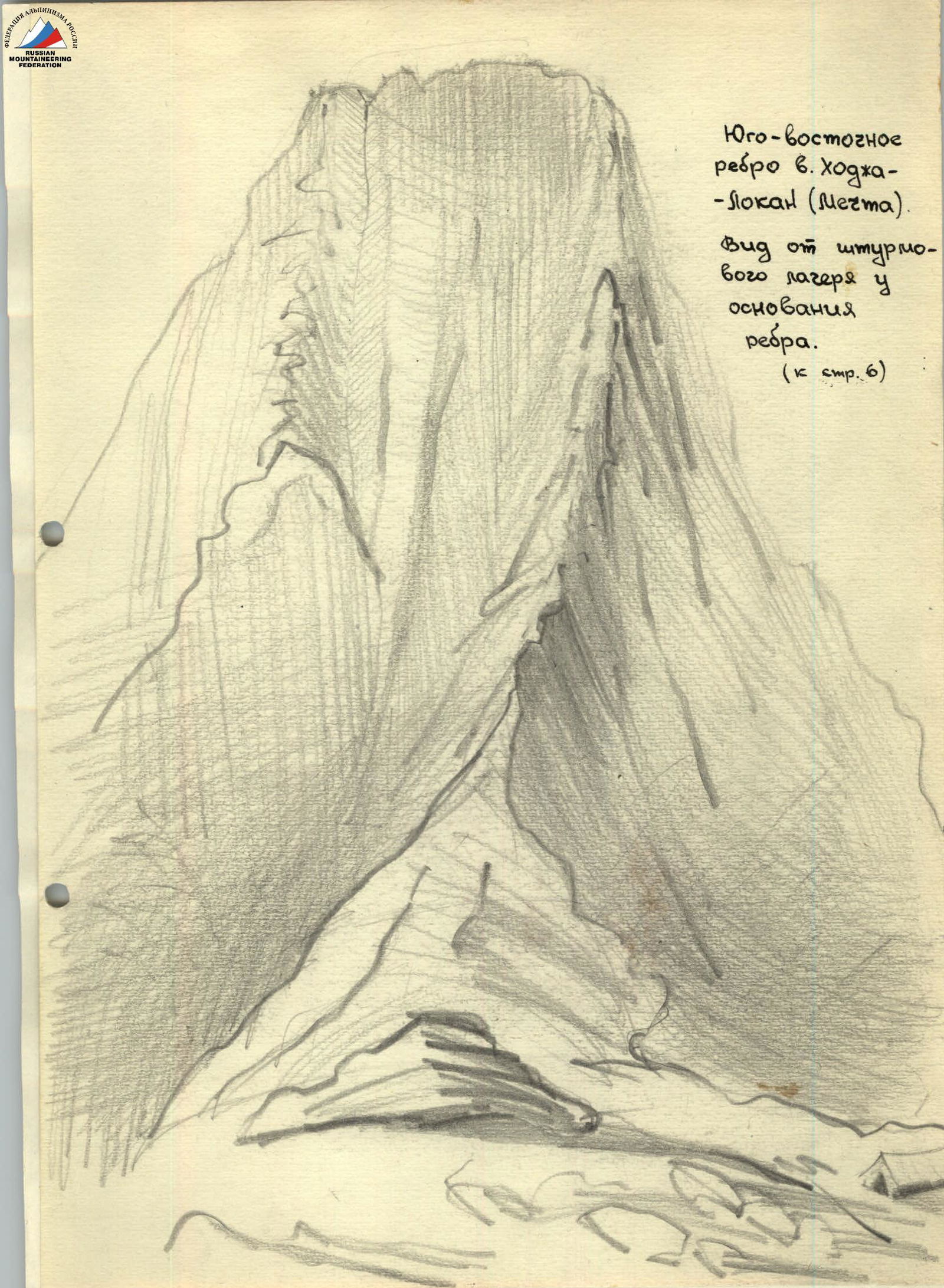
At a gathering organized by the Alpinism Federation of the Tajik SSR and the Central Council of the Tajikistan Sports Society in 1960, one of the groups ascended via the southeast ridge of Mechta, necessitating the creation of this description.
The peak Mechta (Khodja-Lokan):
- Has an elevation of 4767 meters above sea level;
- Is located at the end of one of the short southern spurs branching off from the Hissar range in its central part;
- The spur line drops off with the southeast ridge described below.
The peak is composed of gray granite with dikes of ultrabasic rock (olivinite).
The structure of the peak is shown in plan on diagram 1. Approaches to the described peak can be made via several paths, namely (see the attached map-scheme):
- Along the Karatag River and its tributary Pairon, which is called Kadam-Tash upstream.
- Along the Khanaka River, passing through a low pass (Khanaka) leading to the upper reaches of the aforementioned Kadam-Tash.
- Along the Sioma River, passing through the Chetyrekh pass.
All approaches made by Tajik climbers to the peak Khodja-Lokan were made separately via the third of the mentioned options. Here's its description. The Sioma River is a major right tributary of the Varzob River, which is called the Dushaminka River downstream, at the level of the republic's capital. Sioma flows into Varzob 300-400 meters above the Varzob alpine camp. At the level of the camp, a cable is stretched across the Varzob, on which a mольka (a type of cable car) operates, serving as the only means of crossing the river at this point (watch your fingers!).
After crossing and walking 300-400 meters upstream on the old road, climbers arrive at the confluence of Sioma and Varzob. A good trail goes up the right bank of Sioma. The right tributary Igizak (within 1.5-2 hours of walking) flows into Sioma not immediately, but a significant distance (200 meters) away - the two streams run parallel, separated by a ridge 40-60 meters wide.
Crossing Igizak to the ridge does not present difficulties. It is more challenging to cross Sioma. There are possibilities for a suspended crossing (there are trees and large stones on the banks), and when the water level is lower, it is possible to ford the river at the point of its wide spread.
The path continues upstream along the left bank of Sioma. The river valley becomes wider. The trail is well-defined. Twice, the valley is blocked by stone blockages, which are an obstacle for pack animals (for unloaded donkeys, the blockages are passable).
Within 8-10 hours after crossing, one can reach the edge of the vegetation; here, the moraines of the Big Sioma glacier begin. The elevation is about 3 thousand meters. Ahead - to the west - the valley is blocked by the ridge of the Kороны Siомы peaks, to the left of which is a depression - this is the Chetyrekh pass (see photo). The path to Khodja-Lokan lies through it.
Along the moraines and ice, it takes about an hour to reach the base of the steep ascent leading to the pass. Until mid-August, this ascent is snowy; later, it takes on the character of a small scree. Within 20-35 minutes, climbers ascend to the pass point, and from here, a good view of Mechta and the surrounding mountains opens up. Mechta is "as on a palm" (see photo).
From the pass, the ascent route via the NE wall (category 5A) is visible, and the left profile of the peak is the route described below. The elevation of the Chetyrekh pass is about 3500 meters above sea level.
From the pass, we descend along snowfields and large scree towards the base of Mechta. Soon, we reach the Kadam-Tash stream. We cross it via stones and then, trying not to lose elevation, move along, traversing the scree on the eastern slopes of the peaks located north of Mechta, and then Mechta itself.
Within 4-5 hours after passing the Chetyrekh pass, having overcome several counterforts descending from Mechta, we reach the base of the southeast ridge. Between this ridge and the last counterfort, a stream bursts out of the slope. 200 meters from this source, the sheer cliffs of Mechta begin.
At the base of the southeast ridge, there are several areas where, within 3-5 minutes of walking from the spring, excellent overnight stays can be arranged. From the overnight stay, a significant part of the ascent route is visible.
To accomplish the approach from the Varzob alpine camp to the described overnight stay, 2-2.5 days should be allocated.
A significant part of the ascent route runs literally along the "crest" of the southeast ridge. This ridge is between half a meter and several meters wide.
Climbers need to:
- Deviate to the left in several cases
- Deviate to the right only once
A few dozen meters to the left of the route, a steep couloir runs, turning into a concave wall at the top. Rockfalls and entire collapses have been repeatedly observed along this wall and couloir during the ascent, with some debris reaching the route line.
The upper part of the aforementioned concave wall is a "live" ridge 45-60 meters high. Thus,
 western ridge, route 3B
Mechta pass
northeast wall, route 5B
southeast ridge, described route
wall, lower part - couloir (rockfall hazard!)
Diagram 1 (to p. 4)
western ridge, route 3B
Mechta pass
northeast wall, route 5B
southeast ridge, described route
wall, lower part - couloir (rockfall hazard!)
Diagram 1 (to p. 4)
after overcoming the labor-intensive sheer part of the ridge, climbers must navigate this hazardous "live" ridge. After it, an icy ascent blocks the way to the summit. This is how the route along the southeast ridge proceeds to the highest point of Khodja-Lokan.
On the rocky part of the route, water is almost nonexistent. It is possible that in the first months of the climbing season, some ledges will retain snow remnants. Until mid-September, a small amount of snow remains on the ledge running from the large gap (see diagram 2) northward.
The described ridge is highly exposed to the southeast, over the Kadam-Tash valley; due to this, climbers experience significant emotional stress.
For convenience, the entire route should be divided into 5 unequal sections, namely (see diagram 2):
I. The stage where movement is along rocks of medium difficulty, with sections of simultaneous movement (length about 250-300 m). II. Difficult rocks to the large gap (about 500 m). III. Large gap - 2nd gap. Left-hand detour - difficult climbing (100 m). IV. Exceptionally difficult climbing (250 m). V. Hazardous rocks at the exit to the ridge (about 100 m). VI. Along the ridge to the summit (elevation gain about 125 m). Total elevation gain from the storm bivouac to the summit is about 1300-1400 meters.
The ascent proper begins with bypassing the rocky outcrops at the base of the southeast ridge. These rocks are bypassed on the left via couloirs filled with loose scree. The further path is logical, running near the line where the southern and eastern slopes meet. Sections of easy climbing alternate with rocks of medium difficulty. One should not deviate significantly to the left due to the high risk of rocks falling down a very steep couloir. Occasionally, ice fragments fly down.
The boundary between the first, relatively easy stage of the ascent, and the next is marked by a smoothed rock face 20 meters high (see diagram 3). At first glance, there seem to be two options, but it soon becomes clear that the chimney cannot be passed because the exit at the top is blocked by a huge plug protruding outward. To the left of the chimney, a crack runs upward to the right, with two notable stones:
- One stone, lying at the entrance to the crack, is the size and shape of a Pamir tent;
- The other, darker and smaller, is wedged into the crack with its sharp edge at a height of 4-5 meters.
The path runs through this crack. Climbing is difficult, and with a backpack, impossible, so here, for the first time, backpacks need to be pulled up with a rope. After passing through the chimney plug and overcoming a 3-4 meter wall, climbers reach a small platform where they can organize a reception for their backpacks. This section marks the beginning of the second stage of the ascent.
The path proceeds almost exactly along the ridge, which has the character:
- sometimes a slightly convex wall,
- sometimes an internal corner,
- sometimes a sharp external corner.
Large sections are occasionally interrupted by slabs with a southeastern exposure. Unfortunately, the first ascenders were unable to sketch (let alone photograph) each challenging section. Segments of the route without distinctive relief forms or memorable landmarks were not sketched, nor were those whose passage would not be facilitated by prior study of their descriptions.
Approaching the section depicted in diagram 4, climbers planned their route along the upper of two almost parallel ledges running left upward to the right, as the ascent via the lower ledge leads to a chimney filled with stones. However, the exit from the upper ledge to the upper part of the chimney proved very difficult due to the need to traverse 4-5 meters of a completely smooth wall. The difficulties here included passing part of the chimney filled with stones. The rock here has the character of schist with a vertical layer orientation, and in several cases, the upper stones protrude more than those below.
It is possible to drive 1-2 hooks into the left-hand wall of the chimney, used:
- as belay points,
- for support.
Backpacks need to be "pulled up".
Several short but labor-intensive sections on the logical path lead to an internal corner primitively depicted in diagram 5. The crack running along the corner is oriented such that one can insert a hand into it, but it is not possible to hold onto it. Apparently, the most advantageous approach in this case is a "human ladder": from a товарищ's shoulders, one can reach the upper edge of the corner.
The next interesting section is the one attempted to be depicted in diagram 6. It is a beautiful, smoothed rock face of yellow-gray color, 20-25 meters high. A distinctive feature of this section is the complete absence of cracks for driving hooks in the lower half of the wall.
The section has an overall steepness of at least 75-80°, and climbing here requires significant technical, physical, and mental effort. The possibility of driving hooks appears only in the upper part of the wall, where a vertical crack begins to emerge. Naturally, backpacks are "pulled up".
Next follow inclined (to the left along the route) slabs. The path, 15 meters long, runs along them, along their right edge adjacent to the wall. Then, about 30 meters of climbing along difficult rocks follows, where there are 2 convenient ledges for belaying.
The exit is onto a 1 × 1.5-meter platform, covered with stones and featuring a vertical needle-like protrusion 0.5-0.7 meters high. After this, ahead lies an interesting section (diagram 7), consisting of two overhanging walls separated by a 2-meter gap filled with some layered rock in a vertical plane.
One of these plates is the size of a large book; others are up to 10-15 cm thick, but together they form an interesting, though very dangerous, ladder 7-8 meters high.
Having reached the top, climbers find themselves on a section closest to the rockfall-prone couloir on the left. Here, the further route cannot be laid out other than along a smooth wall 25-30 meters high (diagram 8).
In the lower part of this wall, there is a two-meter stone block detached from the monolith, from the upper edge of which extremely difficult climbing begins. In the first half of the wall, climbing is somewhat easier due to a vertical crack, allowing for the placement of several hooks used for support.
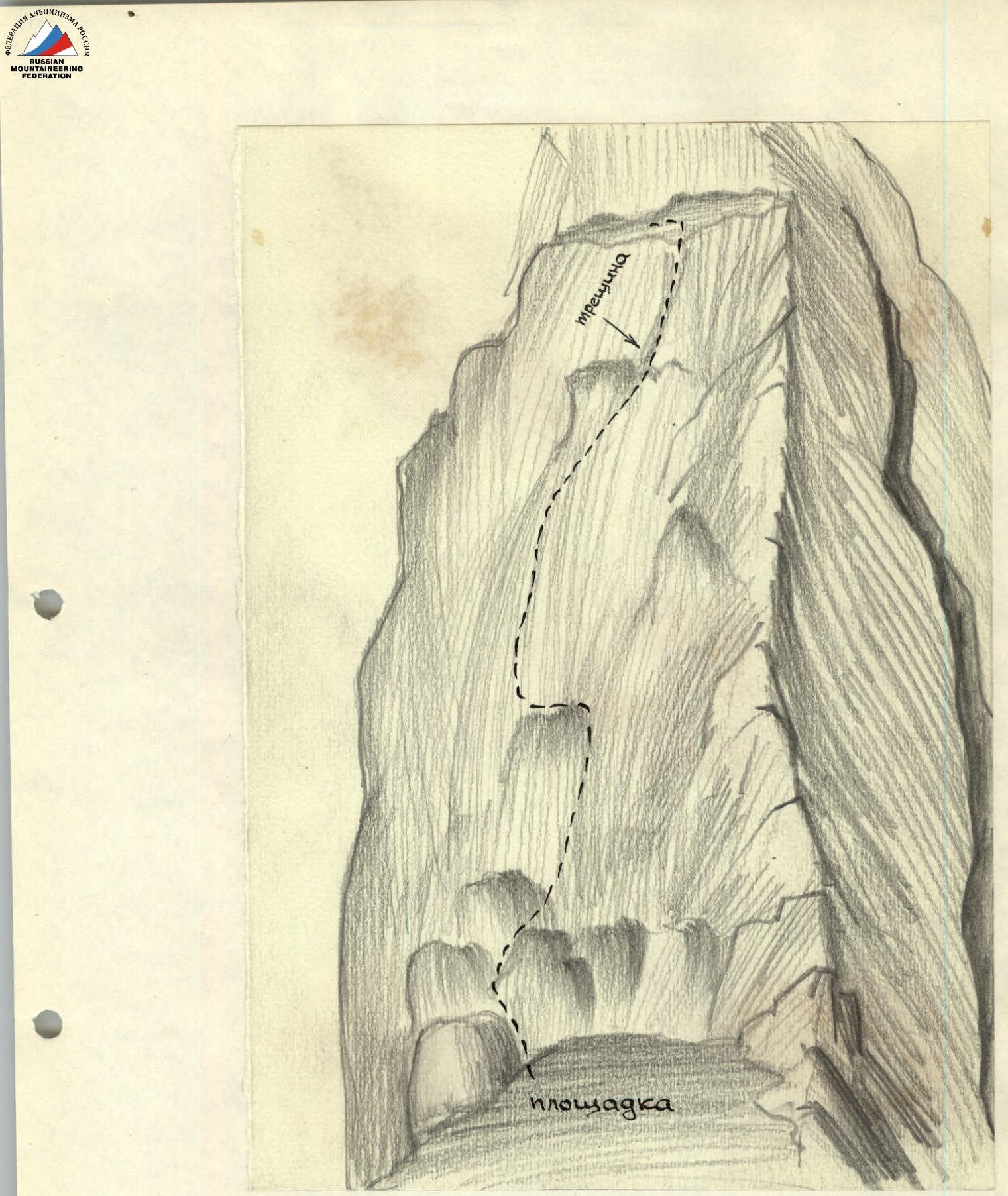 Diagram 7 (to p. 10)
 Diagram 8 (to p. 10)
In the upper part of the wall, the use of bolt hammers is desirable; however, the first ascenders did not have them. Climbing in this section is very difficult and no less dangerous. The smooth wall leads to a corner (marked + on diagram 8). This corner is formed by the overhanging rocks above and the wall on the right. To overcome this section, a ladder suspended on hooks driven into a wide crack is necessary (it is advisable to use wooden wedges).
The overhanging rocks above become somewhat gentler and turn into slabs leading to the base of the next challenging section (diagram 9). The height of this section is 45 meters; however, it can be divided into 2 parts, with a crack (+ on diagram 9) serving as an intermediate point.
The mentioned 2 sections of difficult climbing lead to a ledge, to the right of which climbers can exit into a large gap. Here, the second stage of the ascent ends (see diagram 2).
The next stage is approximately 100 meters high. This stage connects the large gap with a smaller gap. The route on this stage is chosen without much difficulty; there are several path options; all are challenging and run slightly to the left of the ridge line. The first ascenders began their path from the large gap along the route depicted in diagram 10.
The small gap (see diagram 2) is a wide ledge, above which stand solid walls. The next, IVth, most challenging stage of our ascent runs along these walls.
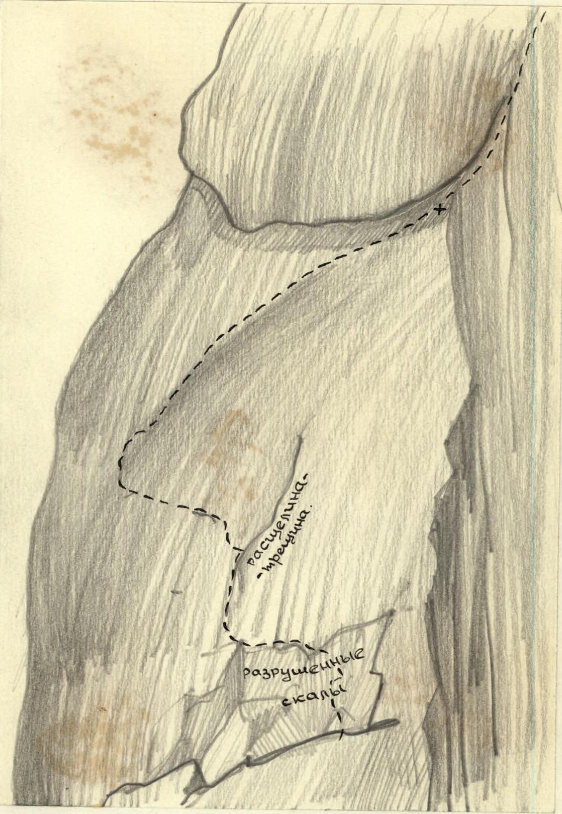 Diagram 9 (to p. 11)
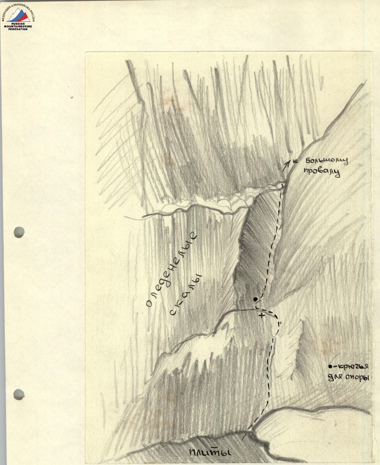 Diagram 10 (to p. 11)
Unfortunately, the first ascenders were unable to make drawings at this stage, as the further path was visible only for a short distance. The entire stage is a smooth, solid 250-meter wall, whose passage is very challenging due to the lack of holds. For this wall, the use of bolt hammers and ladders or platforms is recommended. Due to the fact that one section of the wall (a 30-meter overhang) was impassable for the first ascenders, they had to seek a detour. The climbers, leaving their backpacks on the ridge, pendulum-descended onto one of the ledges on the right along the route, then, after difficult climbing upward to the left, returned to the ridge 20 meters above the left backpacks. One of the climbers descended to the backpacks and, after pulling them up, ascended with the help of étriers and a Prusik knot. At this IVth stage of the ascent, backpacks had to be pulled up about ten times, which, after difficult climbing, represents a significant additional load. It took the duo of first ascenders 18 working hours to pass this stage. A bivouac is conducted "on the hooks". The first ascenders cannot indicate a place on the stage where a bivouac would be more convenient compared to other points on the stage.
The ascent of the southeast ridge of Khodja-Lokan, along which the route runs, changes its steepness at an elevation of approximately 4550 meters above sea level; closer to the summit, the ridge becomes more gentle. Here lies the boundary of our conditional stages - here, the stage of difficult climbing ends, and the path along the destroyed and therefore hazardous ridge crest begins. Not reaching 30 meters to the point of a sharp change in the ridge's steepness, climbers are forced to deviate to the left along the route, as an ascent along the steep ridge to the gentler part is impossible - a smooth wall (20 meters) above is "crowned" with huge overhanging stones. Deviating to the left, climbers find themselves on a ledge 0.5 to 1 meter wide and 15-20 meters long, which drops off with a concave wall, turning further into a wide but steep (75-80°) rockfall-prone couloir mentioned earlier. The couloir is "fed" by stones and ice fragments falling from the crumbling upper part of the southeast ridge. The ledge, onto which the climbers turned, abuts an overhanging wall. The further path is an ascent from the ledge to the ridge. The section is short but hazardous due to its "live" boulders. The first ascenders began their ascent from the ledge in its middle part, where, as it seemed, the danger was minimal. The length of the ascent (from the ledge to the ridge) was 50-60 meters. However, a direct exit to the ridge is not possible. It is necessary to traverse further to the left and only then, using the ice that cements the destroyed ridge, to reach the ridge line. Climbing here is emotionally charged, as below, if not considering the mentioned ledge, lies a wall turning into a couloir and dropping down not less than a kilometer.
The further path goes along a not very challenging ridge crest. The only serious obstacle on the final stage is an ice wall 50 meters long and with a steepness of 70°. The wall leads to an almost horizontal part of the ridge, after passing which climbers reach the highest point of the summit.
The descent is made along the western ridge via the category 3B route.
The further return is through the Mechta pass, category 2A.
The duo of first ascenders (two 1st class climbers) spent 36 working hours on the ascent along the southeast ridge, and 7 hours on the descent along the western ridge.
The group had 3 bivouacs during the ascent.
The ascent was made between September 15-20, 1960, in excellent weather. The route taken, in the opinion of the first ascenders, corresponds to category 5B.
Ascenders:
- MASHKOV Vladimir Sergeevich, born 1931, doctor, Sports Society "TADJIKISTAN"
- FADEEV Vladimir Sergeevich, born 1935, engineer, Sports Society "TADJIKISTAN".
Observers:
- PAN'KOV Rostislav Grigorievich, born 1932, engineer, Sports Society "TADJIKISTAN"
- AVER'YANOV Valery Konstantinovich, born 1937, student, "BUREVESTNIK"
- AKHMETSHIN Mingazim Kasymovich, born 1932, engineer, Sports Society "TADJIKISTAN"
- RYAZANOV Dmitry Konstantinovich, born 1935, laboratory assistant, Sports Society "TADJIKISTAN"
 Description compiled by V. MASHKOV