up 536 21.0289 Part 1 1036 1046 Ascent Report
Climb Category: Combined
Ascent Area: Gissar Ridge, Surkh-Kuh spur.
Peak, its height, and ascent route:
- Peak Surkh-Nu via the central counterfort of the southeastern wall
- Height: 2980 m
Estimated Difficulty Category: 3A
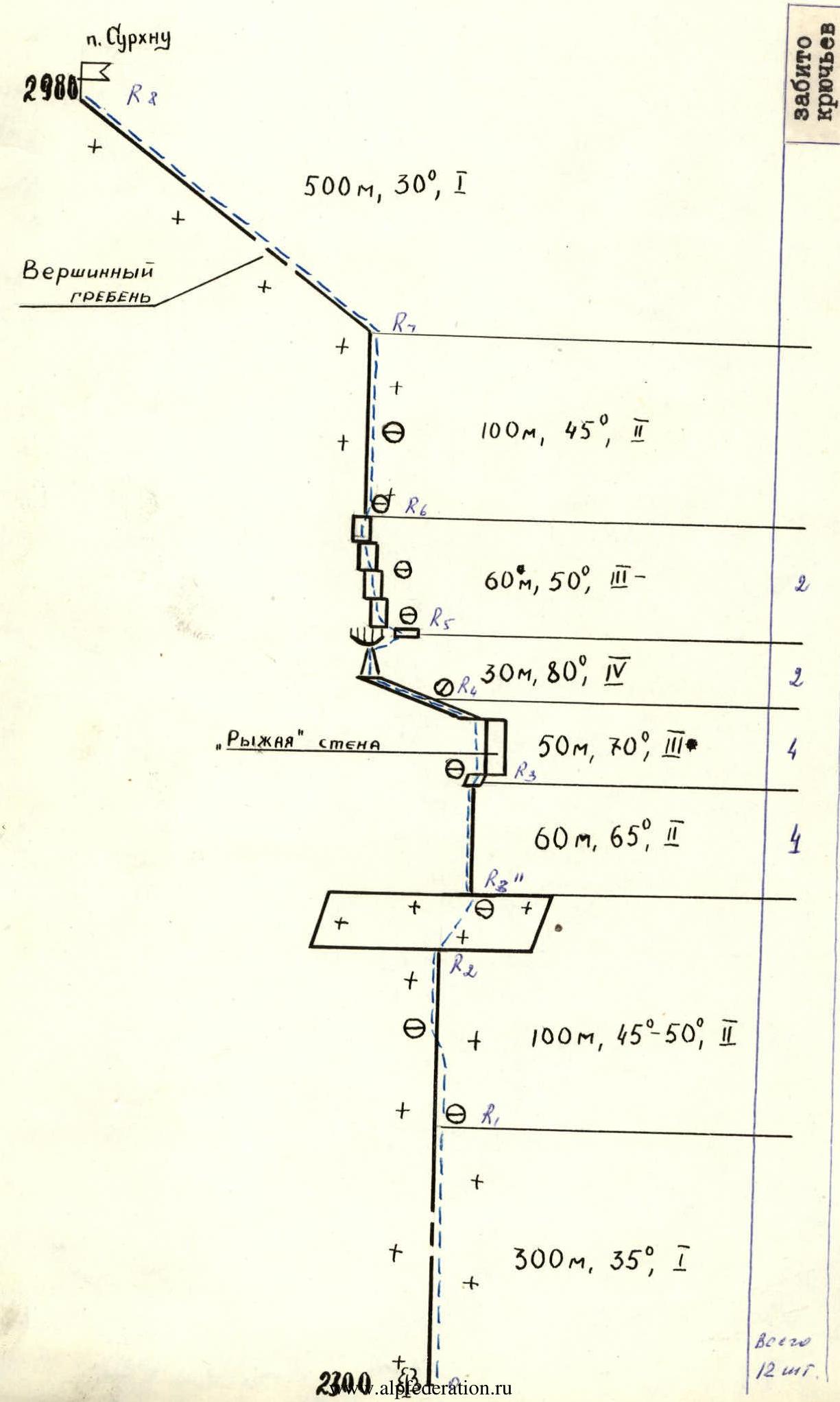
Route Characteristics: 680 m elevation gain, average slope 45° Section Lengths:
- 1: 800 m
- 2: 260 m
- 3: 110 m
- 4: 30 m
- 5: — m
- 6: — m
Pitons Hammered:
- For Belaying:
- Rock: 8
- Ice: —
- Bolt: —
- For Creating I.T.O.:
- Bolt: 2
Climbing Time: 9–10 hours
Number of Nights and Characteristics:
Leader's and Participants' Last Name, First Name, Patronymic, and Sports Qualification:
- Lorenz Evgeny Olegovich, 1st sports category
- Eisenberg Viktor Aromovich, Candidate Master of Sports
- Shcherba Anatoly Yakovlevich, 1st sports category
Team Coach: Rizaev Leonid Mukhamedovich
Departure and Return Dates: January 1, 1980, January 2, 1980.

Area Map
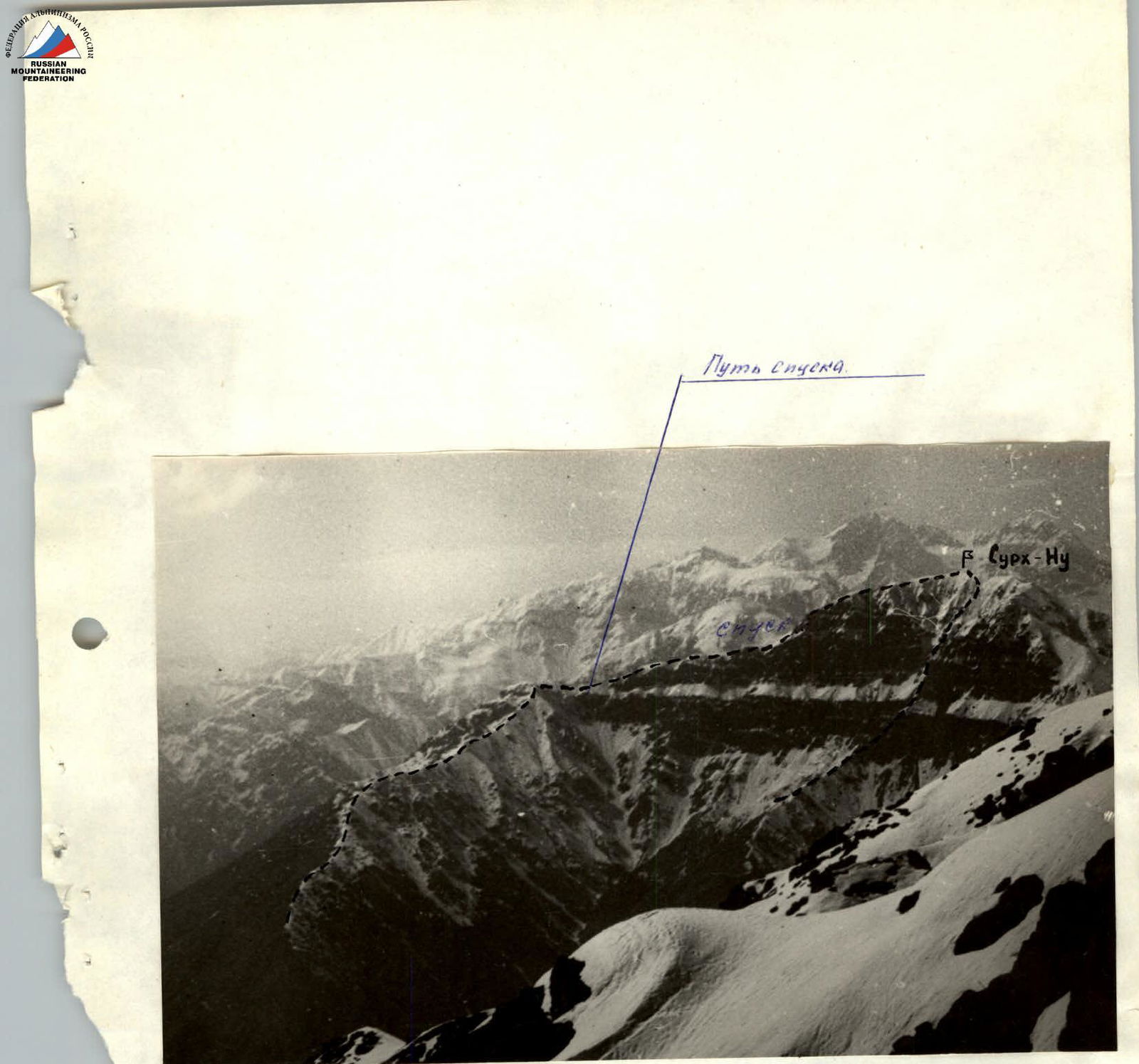
Profile Photo of the Route
Brief Route Description
- 0–I 300 meters up a snowy ridge to rock outcrops and then
- I–2 along a combined ridge to a wide ledge with a slope of 60–65 degrees. The ledge is covered with flow ice and is traversed from left to right upwards.
- 2–3"
- 3–8 The ledge leads to the base of the counterfort. We ascend to the upper part of it via несложным скалам. 60 m.
- 8–4 Above the counterfort is a "rusty" wall with a cleft, which is bypassed on the left along the rocks covered with ice. We ascend to a saddle between the wall and the counterfort, to an inclined ledge.
- 4–5 Along the ledge, moving left, we reach a gully. Up the gully under an overhanging slab and, bypassing it on the right, we reach a saddle-ledge.
- 5–6 Further, 60 m up rocks of block type. Flow ice is encountered. Climbing is of medium difficulty. The rocks lead to a snow-ice ridge.
- 6–7 The snow-ice ridge leads to the South pre-summit ridge of the right shoulder of the peak. Across the shoulder, we reach the Western Main ridge of the Surkh-Nu massif and follow it to the summit.
- 7–8
Recommendations
- The route is combined. Strong wind. Attention should be paid to the correspondence of the athletes' equipment.
- To the saddle (section R3–R4), several equivalent ascent paths are visible.
Peak Surkh-Nu via the central counterfort of the southeastern wall.
From the base camp located on the R2–R3 ridge of the peak, descend down to the stream and ascend along the long, gentle, forested in its lower part, central ridge. The ridge becomes gentler and then again steeply rises upwards (slope 45–50 degrees), leading to a wide, snowy ledge that cuts through the wall in its middle part across its entire width. Straight ahead, a counterfort stands out. 60 m up the несложным скалам of the counterfort to its top.
Key section. Directly above is a "rusty" rock with a wide vertical crack. The rock is bypassed on the left. Exit to a saddle between the rock "blade" and the rock massif. From the saddle, traverse the wall left upwards along a narrow, weakly expressed ledge to a steep gully 15 m long. Difficult. Up the gully under an overhanging slab and traverse right to a saddle. Difficult.
Further, 60 m up rocks of stepped structure. Climbing is of medium difficulty. Exit to a 100 m snow ascent with a slope of about 50 degrees and ascend to the summit ridge. Along the gentle summit ridge, 500 m to the summit.
Descent from the summit along the несложному R1–R3 ridge to the base camp. The ascent takes 8–9 hours.