Ascent Passport
I. Ascent category
- technical
- Ascent area
- Pamir-Alay, Gissar Ridge.
- Peak, its height, ascent route
- p. Studencheskaya 3792 m, via W wall.
- Estimated category of difficulty
- 5A
- Route characteristics
- the route is combined, height difference – 510 m.
- average steepness of the wall section 75°.
- length of sections with 5th cat. of diff. 230 m.
- Number of climbing hours (excluding descent) – 8 hours.
- Nature and number of bivouacs – no bivouacs
- Pitons hammered – rock 49 pcs., chocks 15 pcs.
- Team of a/l Varzob – group of instructors.
- Full name of the leader, participants, their qualification
- Kapitanov O.V. – MS, captain.
- Klestov Valery Iosipovich – CMS, participant.
- Kudryashov Valery Sergeevich – CMS, – "–"
- Kuleshova Elena Vasilievna – CMS, – "–"
II. Team coach – head of training Kapitanov Oleg Viktorovich.
12. Date of departure for the route and return August 28, 1981.
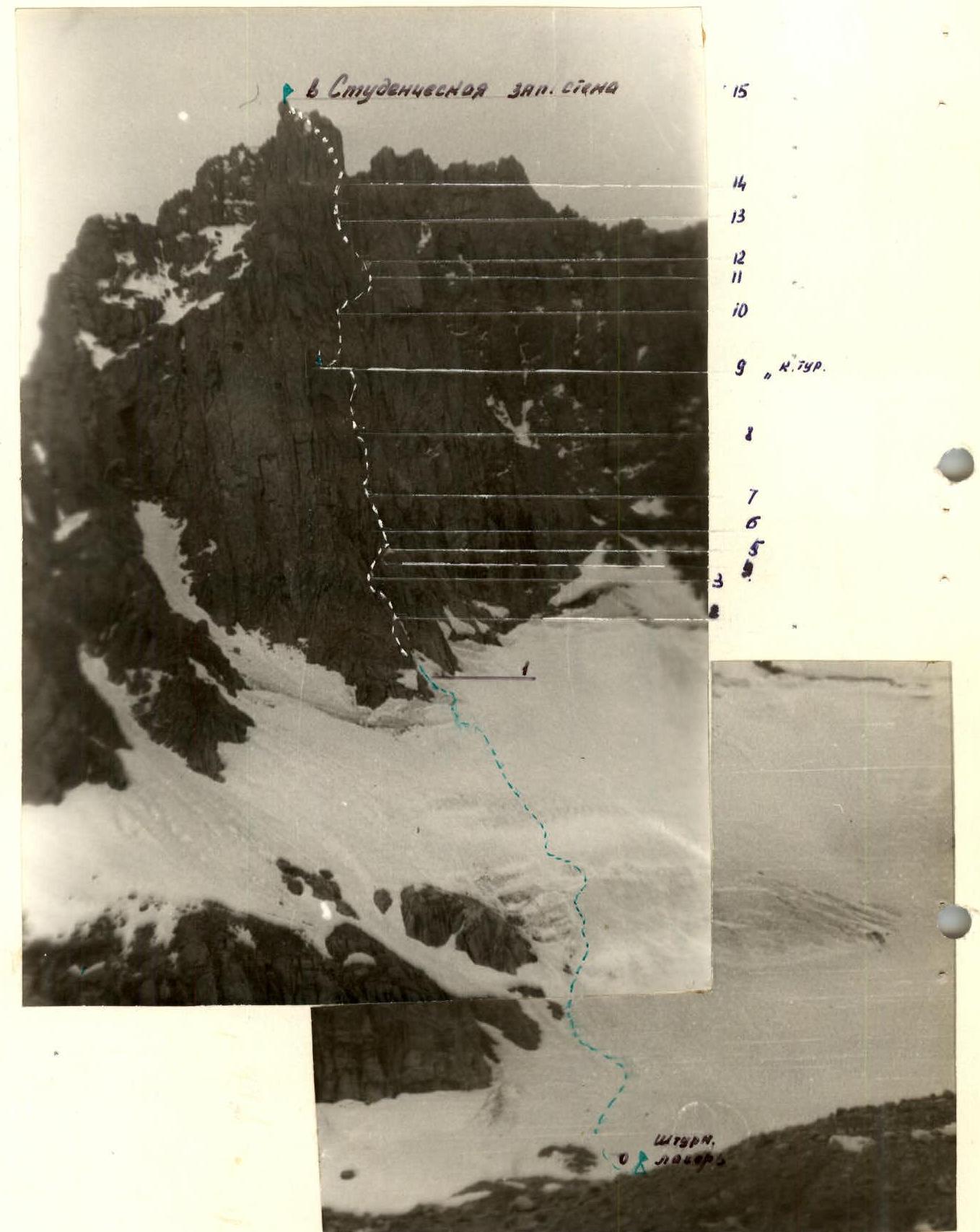
General view of the peak (semi-profile)

Map-scheme of the "Upper Siama" area
- — climbers' route
- Δ — assault camp
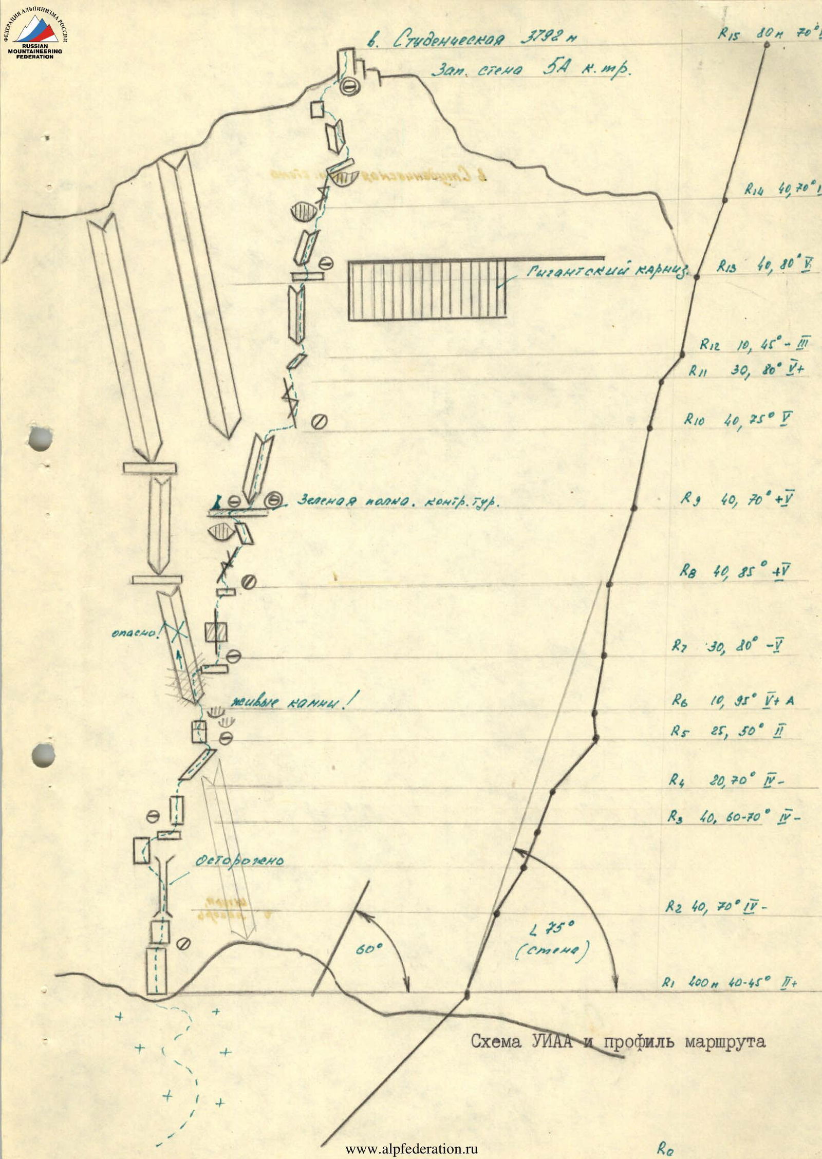
Table of main characteristics of the ascent route to p. Studencheskaya via W wall 5A cat. of diff.

Brief description of approaches and route sections
From the Upper Siama base camp, descend down the trail 350–400 m and cross to the right bank of the Siama River via a snow bridge. Then, downstream along the river, bypassing the gorge of the p. Festivalnaya massif, descend to the foot of p. Studencheskaya. — 1 hour. We go around the peak from the right and ascend via the old overgrown terminal moraine to the western slopes of the massif. Then, along the moraine ridges, we move towards the tongue of the glacier flowing from the p. Studencheskaya cirque. Here, on the moraine, it is most convenient to set up an assault camp. The entire approach to the bivouac from the Upper Siama base camp takes 2.5–3 hours.
The route is combined. It can be conditionally divided into 2 sections:
- 1st — ice-snow slope of the p. Studencheskaya glacier — 400 m
- 2nd — western wall of the peak — purely rock — 485 m.
The first part of the route does not present technical difficulties. Section R0–R1 is traversed with simultaneous movement in rope teams on crampons. The slope's steepness varies from 40 to 45°. The direction of movement is to the right of the protruding "ram's foreheads" on the left, bypassing crevasses. In the middle part, the glacier becomes slightly gentler, and the wall section of the route is clearly visible here. See photo I.
The left part of the western wall of the peak protrudes slightly in the lower part with a short, wide buttress. At the bottom, in the right part of the buttress, an internal corner is visible, separating the buttress from the wall in a direction from right to left upwards.
The route must be carefully examined, and landmarks must be identified: a giant corniche, a green ledge, etc. — see description and UIAA diagram.
The route begins under the base of the internal corner, which we reach by overcoming a relatively easy bergschrund.
Sect. R1–R2 Up the grey-colored wall, which has many loose rocks from melted snow, 40 m to the base of the internal corner.
Sect. R2–R3 Up the corner. The corner in the lower part resembles a chimney. Its walls have loose slab-shaped rocks, so it is advisable to exit the corner after 20 m onto the wall and move along it to the left towards the beginning of the corner, i.e., its upper part. Further progress is only possible after the entire group exits the corner, as the lower climbers can be hit by falling rocks. The group can regroup on a small inclined ledge.
Sect. R3–R4 From the ledge, up a 15-meter wall to the base of a ledge consisting of inclined slabs with a steepness of 50°. The slabs have rocks on them. We ascend from left to right, bypassing a rock bastion.
Sect. R4–R5
Sect. R5–R6 In the right part of the ledge, we move upwards to the left along a wall with an overhang. Climbing is complex, using artificial climbing aids. Through the overhang, we enter an internal corner descending from the peak ridge.
Sect. R6–R7 The corner is destroyed. Movement along it (safe) is not more than 20–25 m, and then to the right onto a ledge. Further ascent along the corner is visible but is very dangerous and not recommended for our followers.
Sect. R7–R8 An external corner descends to the ledge. Up the right edge of the corner along a crack, with a transition after 20 m to its left edge. Between cornices — through an overhang, using artificial climbing aids — into an internal corner.
Sect. R8–R9 The internal corner is wide. We traverse it with free climbing, possibly using artificial climbing aids if necessary. In the upper part of the corner — a corniche. We bypass it on the right along slabs and exit onto a wide, scree-covered ledge with sparse grass. Here, it is possible to set up a bivouac.
Sect. R9–R10 Along the ledge to the right — into an internal corner of yellow color, to its upper part. Climbing is complex. The corner is closed by an overhang. From under the overhang, we traverse to the right onto a small ledge.
Sect. R10–R11 From the ledge, up an internal corner with a crack to the left, bypassing a giant corniche — onto a ledge. The ledge is wide. Convenient place for belay.
Sect. R11–R12 From the ledge, the further path upwards is visible — to the left along a rust-colored corner.
Sect. R12–R13 Along the corner — complex climbing. Few cracks. The upper part of the corner is closed by a corniche. We bypass it on the right with free climbing.
Sect. R13–R14 Also an internal corner. Holds are reliable. Climbing is calm. From the corner, we exit onto a balcony — the upper part of a giant corniche.
Sect. R14–R15 Then, along a system of walls, ledges, and internal corners, bypassing the summit tower, keeping to the right, we ascend to the summit. On the summit, it is possible to set up a bivouac.
Descent from the summit to the northeast via a route of 3A cat. of diff.
Recommendations
Team size not more than six people.
Rope length 40 m.
Universal set of pitons, set of chocks №1–ГТ.
Departure for the route not later than 8:00–9:00 am.
Descent from the summit — 2 hours.
Bivouacs are possible on the "green ledge" R9–R10 or under the summit tower; it is also possible to set up a bivouac on the summit.
 UIAA diagram and route profile
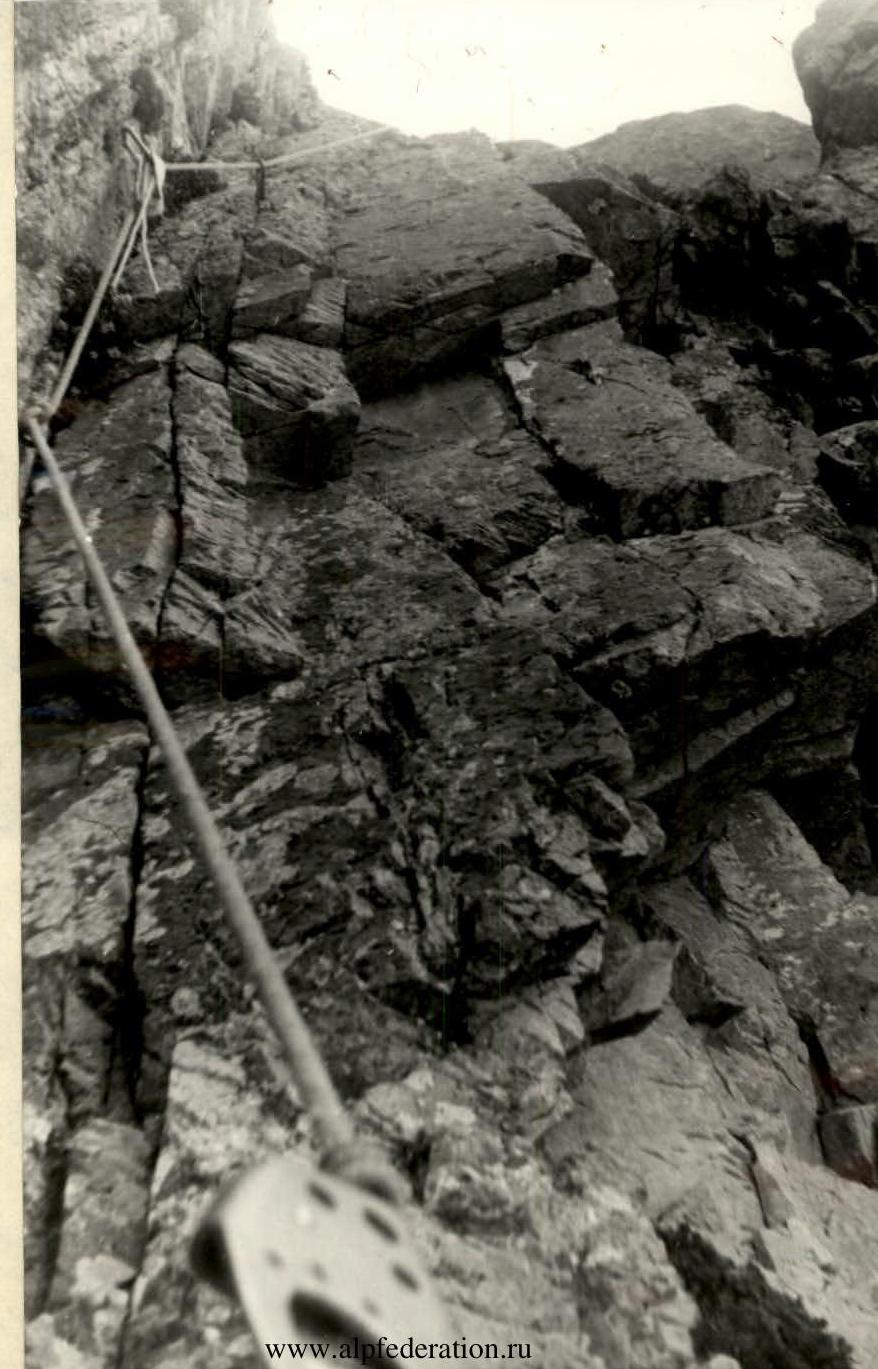 Section R7–R8
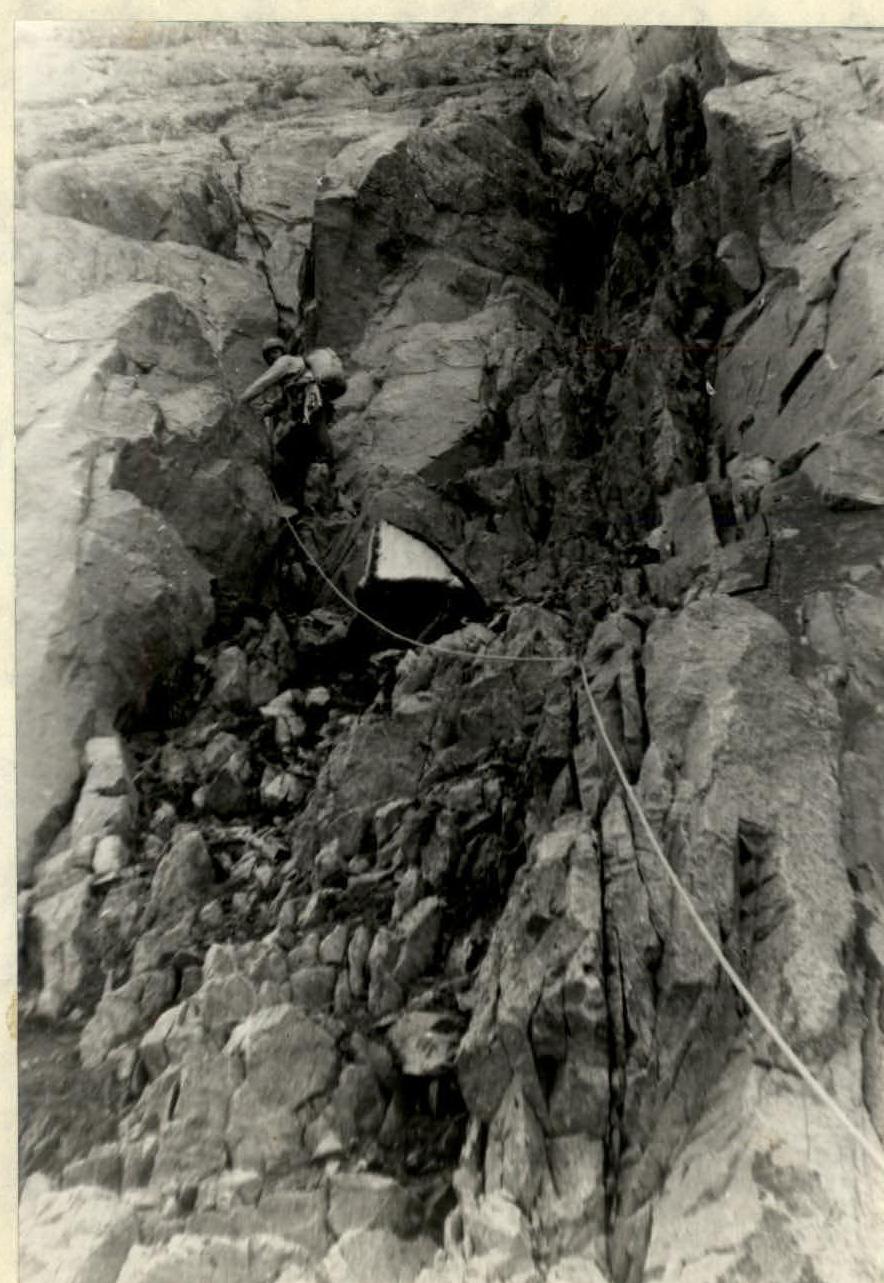 Section R8–R9
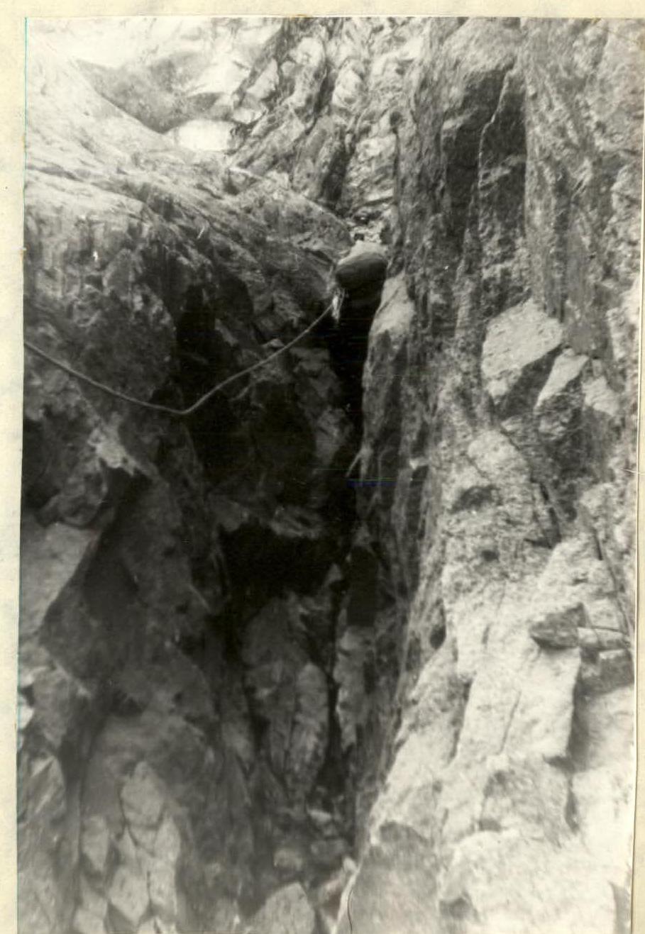 Section R14–R15. Section R2–R3