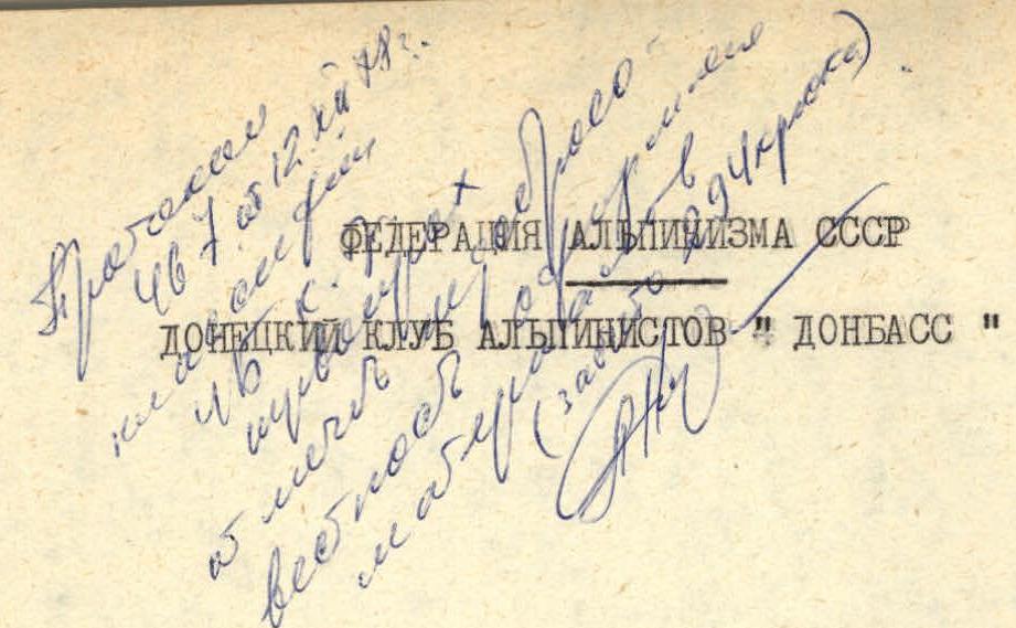
REPORT
On the ascent of peak Siyoh (4100 m) Pamir-Alay, Hissar Range, Osman-Tala mountains 27.06.1978–28.06.1978
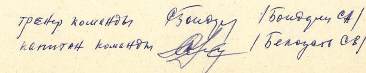
Team members:
- Belousov S.V. — 1st sports category, team leader
- Bezrukov L.D. — participant
- Bratanov A.A. — participant
- Olefir V.V. — participant
- Skalaukhov A.P. — participant
- Somsikov A.S. — participant
Coaches:
- Bondarets S.A. — Candidate Master of Sports
- Sivtsov B.G. — Master of Sports of the USSR, Honored Coach of the Ukrainian SSR
Donetsk — 1978
Route characteristics
| Date | Designation | Average steepness | Length in m | Terrain characteristic | Difficulty category | Condition | Obstacles | Avalanche risk | Sections with "falls" |
|---|---|---|---|---|---|---|---|---|---|
| 27.06.1978 г. | R0–R1 | 30° | 40 | "Sheep's foreheads" | 2А | dry, sunny | 0 | 0 | 0 |
| R1–R2 | 30° | 250 | Snow | 2А | passable in the morning. Rocks! | 0 | 0 | 0 | |
| R2–R3 | 50° | 8 | Ice | 3 | Firm | 0 | 2 | 0 | |
| R3–R4 | 35° | 180 | Snow | 1 | Firm | 0 | 0 | 0 | |
| R4–R5 | 25° | 120 | Snow | 1 | Firm | 0 | 0 | 0 | |
| R5–R6 | 45° | 40 | Ice wall | 3 | Firm | 0 | 5 | 0 | |
| R6–R7 | 30° | 120 | Snow-ice | 2Б | Firm | 0 | 2 | 0 | |
| R7–R8 | 30° | 280 | Snow | 2А | Firm | 0 | 0 | 0 | |
| R8–R9 | 65° | 10 | Wall | 4А | Firm | 3 | 0 | 0 | |
| R9–R10 | 40° | 30 | Slab | 3А | Firm | 4 | 0 | 0 | |
| R10–R11 | 30° | 80 | Smooth slabs | 2Б | "Live" rocks | 14 | 0 | 0 | |
| R11–R12 | 25° | 40 | Snow-ice | 3А | Loose | 7 | 0 | 0 | |
| R12–R13 | 35° | 20 | Snow | 3А | Firm | 5 | 0 | 1 | |
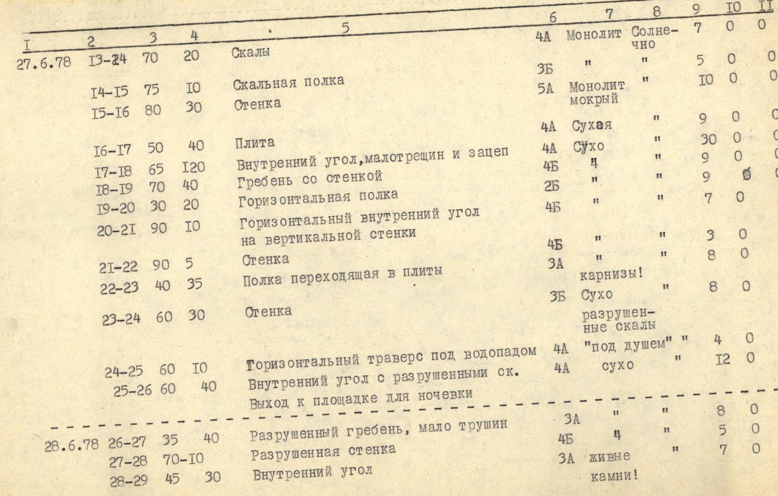
| 27.06.1978 г. | R13–R24 | 70° | 20 | Rocks | 4А | Monolith, sunny | 7 | 0 | 0 |
| R14–R15 | 75° | 10 | Rock ledge | 3Б | 5 | 0 | 0 | ||
| R15–R16 | 80° | 30 | Wall | 5А | Monolith, wet | 10 | 0 | 0 | |
| R16–R17 | 50° | 40 | Slab | 4А | Dry | 9 | 0 | 0 | |
| R17–R18 | 65° | 120 | Inner corner, few cracks and holds | 4А | Dry | 30 | 0 | 0 | |
| R18–R19 | 70° | 40 | Ridge with a wall | 4Б | 9 | 0 | 0 | ||
| R19–R20 | 30° | 20 | Horizontal ledge | 2Б | 9 | 0 | 0 | ||
| R20–R21 | 90° | 10 | Horizontal inner corner on a vertical wall | 4Б | 7 | 0 | 1 | ||
| R21–R22 | 90° | 5 | Wall | 4Б | 3 | 0 | 0 | ||
| R22–R23 | 40° | 35 | Ledge turning into slabs | 3А | Cornices! | 8 | 0 | 0 | |
| R23–R24 | 60° | 30 | Wall | 3Б | Dry, broken rocks | 8 | 0 | 0 | |
| R24–R25 | 60° | 10 | Horizontal traverse under a waterfall | 4А | "Under a shower" | 4 | 0 | 0 | |
| R25–R26 | 60° | 40 | Inner corner with broken rocks | 4А | Dry | 12 | 0 | 0 | |
| 28.06.1978 г. | R26–R27 | 35° | 40 | Broken ridge, few cracks | 3А | 8 | 0 | 0 | |
| R27–R28 | 70° | 10 | Broken wall | 4Б | 5 | 0 | 0 | ||
| R28–R29 | 45° | 30 | Inner corner | 3А | "Live" rocks | 7 | 0 | 0 | |
| R29–R30 | 50° | 40 | Ridge | 3Б | Monolith, "live" rocks! Sunny | 11 | 0 | 0 | |
| R30–R31 | 60° | 20 | Broken inner corner | 3Б | Dry | 5 | 0 | 0 | |
| R31–R32 | 85° | 10 | Chimney | 4Б | 8 | 0 | 0 | ||
| R32–R33 | 60° | 60 | Inner corner | 4А | 18 | 0 | 0 | ||
| R33–R34 | 50° | 10 | Snow slab | 4А | 5 | 0 | 0 | ||
| R34–R35 | 55° | 30 | Broken rock wall | 4Б | Cornices! | 6 | 0 | 0 | |
| R35–R36 | 35° | 10 | Ledges under the wall | 3А | Dry | 5 | 0 | 0 | |
| R36–R37 | 85° | 30 | Inner corner | 5А | 9 | 0 | 1 | ||
| R37–R38 | 50° | 70 | Broken ledge | 3Б | "Live" rocks! | 17 | 0 | 0 | |
| R38–R39 | 40° | 40 | Broken rocks | 3А | Exit to a | 8 | 0 | 0 | |
| R39–R40 | 35° | 50 | Snow with rock "islands" | 3Б | 10 | 0 | 0 | ||
| R40–R41 | 50° | 10 | Snow on ice | 3Б | Ice is loose | 4 | 0 | 0 | |
| R41–R42 | 50° | 8 | Inner corner | 3А | Dry | 2 | 0 | 0 | |
| R42–R43 | 15° | 80 | Broken summit ridge | 1Б | 0 | 0 | 0 |
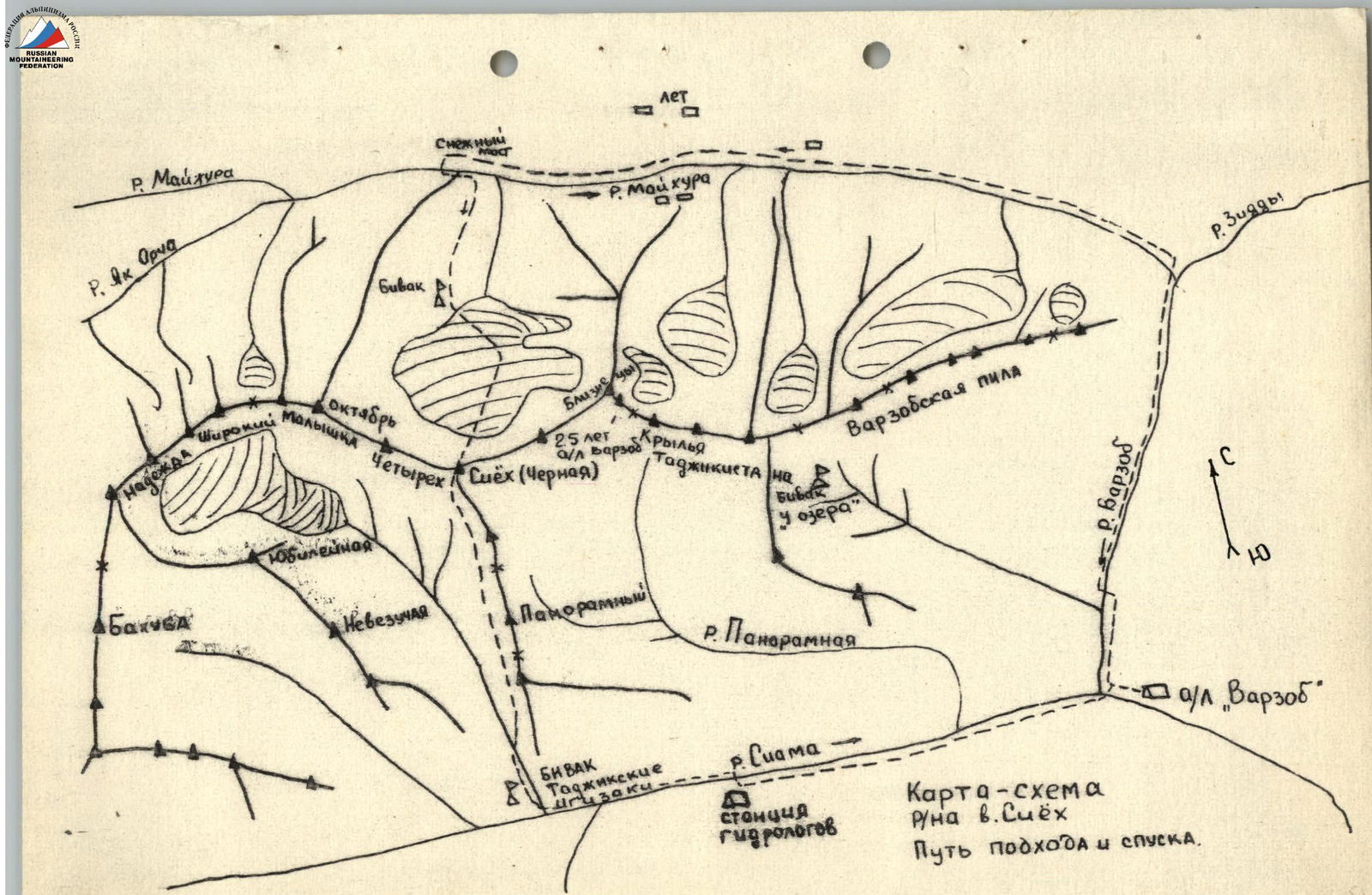
Approach to peak Siyoh
From the Varzob camp, drive 2 km upstream along the Varzob River and turn left at the hydrologists' station. Then follow the dirt road along the Maykhura River. At 10–12 km from the station, the first clearly defined closed gorge is located on the left side of the route. Cross the Maykhura River via a snow bridge located 300–400 m above the entrance to the gorge, and then follow a good trail on the right side of the gorge to reach the beginning of the snowfields (good overnight stays). From the snow bridge, it takes 1.5 hours. From the overnight stay:
- follow the talus and simple snow slope towards the left glacier
- to two nearby streams running down the "sheep's foreheads" (1 hour)
Start of the route.
Brief explanation for Table 1
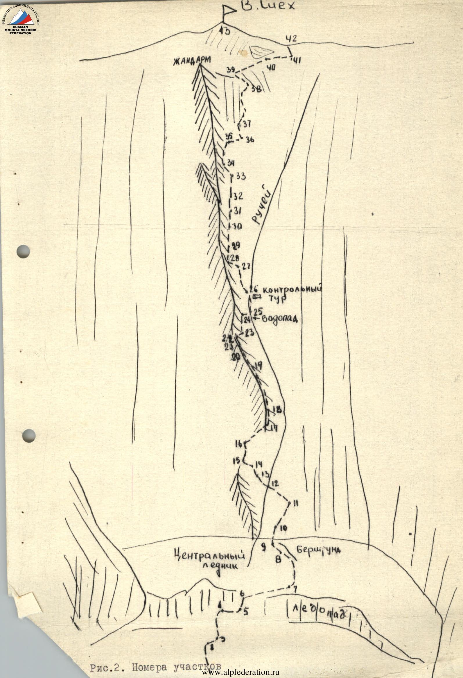
Sect. R0–R1. Traverse "sheep's foreheads" upwards to the right with intermittent belay. Sect. R1–R2. Ascend the snowy slope towards the ice wall. Be cautious, as individual rocks may fall! Traverse this section early in the morning. Sect. R2–R3. Traverse the ice wall from left to right (pitons). Sect. R3–R4. Ascend the snowy slope towards the central glacier's icefall (1.5 hours). Sect. R4–R5. Traverse upwards to the right towards the center of the icefall to the ice wall. Sect. R5–R6. Ascend the ice wall with crampons and piton belay. Sect. R6–R7. Traverse from left to right towards peak Chetyrekh, following snow bridges with intermittent belay. Towards the end of summer, traversing this section may become more challenging. The section ends on the right part of the glacier under the icefall. Sect. R7–R8. Ascend the snowy slope to the left and upwards, below the bergschrund, to its end near the rocks of C-3 counterfort of peak Siyoh. Sect. R8–R9. Ascend the wall to the left and upwards. Monolith with good holds. Sect. R9–R10. Simple climbing on slabs to the right and upwards with good holds. Sect. R10–R11. Straight up between two snowfields towards the wall with a waterfall, following monolithic slabs with small talus. Sect. R11–R12. Traverse to the left to cross the stream and follow a snow-ice slab to reach the rocks. Sect. R12–R13. Ascend to the left and upwards through the snow. Sect. R13–R14. Ascend to the left and upwards through broken rocks towards a vertical monolithic wall. Sect. R14–R15. Traverse to the left towards an inner corner with a water seep. Sect. R15–R16. Ascend a complex, wet wall at the boundary with the inner corner to reach an inclined slab at the base of which the counterfort begins (key location). Sect. R16–R17. Ascend the inclined slab to the right and upwards to approach the base of the counterfort. A stream is located on the right. Sect. R17–R18. Ascend through a smooth inner corner on the right part of the counterfort. Sect. R18–R19. Exit onto the ridge with good holds. Bypass the snow cornice on the right. Sect. R19–R20. Bypass a vertical wall on the counterfort's ridge to the left, following good ledges that turn into a horizontal inner corner. Sect. R20–R21. An inner corner on a vertical wall, turning into a crack (key location), leads to a convenient platform. Sect. R21–R22. Ascend from the platform to the left and upwards along a vertical wall with good holds. Sect. R22–R23. Traverse from the left edge of the ridge to the right between two snow cornices, following inclined slabs (be cautious). Sect. R23–R24. Ascend through broken rocks on the right part of the counterfort, without good cracks, to reach the waterfall. Sect. R24–R25. Traverse the waterfall to the right towards a good ledge. Sect. R25–R26. Ascend through an inner corner to the left and upwards to reach a good ledge. A stream feeding the waterfall is nearby, CONTROL CAIRN. Overnight stay location. 12 hours from the start of the route. Sect. R26–R27. Ascend from the overnight stay through broken rocks upwards. Sect. R27–R28. Cross the stream from left to right and traverse the wall to the left and upwards into an inner corner. Sect. R28–R29. Ascend through a broken inner corner upwards onto a ridge. Sect. R29–R30. Ascend along the ridge, on its right part, to the right and upwards. Sect. R30–R31. Ascend through an inner corner with broken rocks ("live" rocks) straight up. Avoid entering a small couloir that separates a gendarme from the ridge on the left. Sect. R31–R32. Ascend to the right of the ridge. Sect. R32–R33. Vertical red walls of the counterfort remain on the left. Ascend parallel to them through an inner corner towards a snow slab. Sect. R33–R34. Traverse to the left and upwards across a snow slab under a rock wall. Sect. R34–R35. Ascend a broken wall located to the right of the vertical counterfort walls to the right and upwards. Exit onto a platform with a snow cornice. Sect. R35–R36. From the platform, traverse along a ledge on the right part of the counterfort to an inner corner. The inner corner is not visible from the platform. Sect. R36–R37. Ascend through monolithic red rocks of the inner corner with good cracks for pitons, upwards onto the counterfort. Sect. R37–R38. Ascend to the right and upwards through strongly broken, brittle rocks along a ledge to approach a gendarme. Sect. R R38–R39. Bypass the gendarme on the right through broken black rocks with snow sections, "live" rocks! Sect. R39–R40. Traverse a snowy ridge between the gendarme and the summit ridge on its right part. Piton belay on rock "islands". Be cautious, avoid stepping on cornices! Sect. R40–R41. Bypass a large cornice on the ridge on the right, following a snow-ice slab, and exit onto the ridge of peak Siyoh. Sect. R41–R42. Traverse through a short inner corner to the right part of the ridge. Sect. R42–R43. Exit onto the summit through a simple, broken ridge. A geodetic sign is located on the summit. Previously, no mountaineering groups had ascended to the summit.
Descent from peak Siyoh
Return to the point where you exited onto the ridge. Descend along the southern slope of peak Siyoh to the right and downwards through broken rocks and talus (category 1 difficulty, 300–400 m) to a simple snowfield, and then into the gorge (1 hour). Follow the stream along the trail to its mouth. Cross the stream via the hydrologists' bridge. Continue along the left bank of the Siama River to the cableway. Cross the river here. Cross the lateral tributary via a bridge located above the hydrologists' station. Follow the right bank of the Siama River until it merges with the Varzob River. Cross the bridge, and the Varzob camp is on the right. 4–5 hours from the summit to the camp.
Table 2. Equipment, clothing, footwear taken for the ascent of peak Siyoh
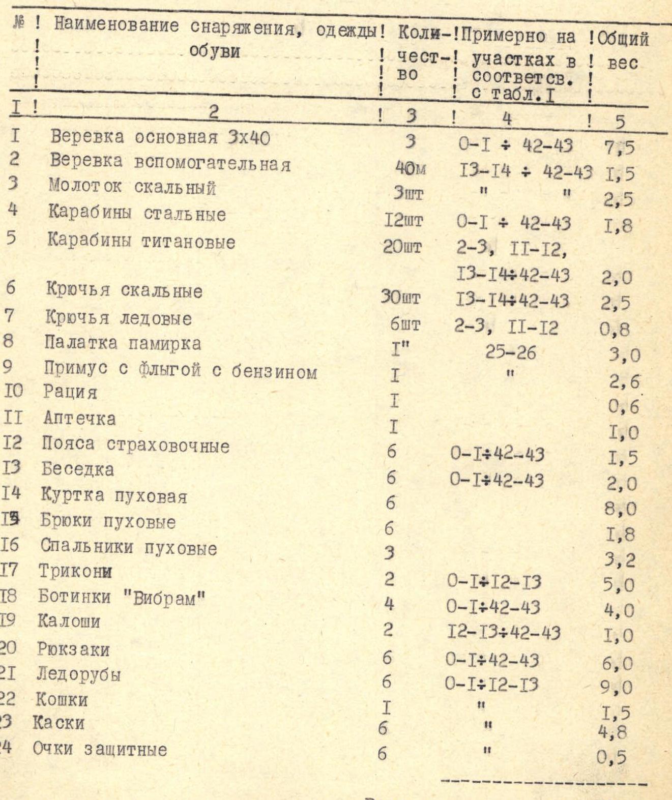
| № | Name of equipment, clothing, footwear | Quantity | Sections (corresponding to Table 1) | Total weight |
|---|---|---|---|---|
| 1 | Main rope 3х40 m | 3 pcs. | R0–R1, R42–R43 | 7.5 kg |
| 2 | Auxiliary rope | 40 m | R13–R14, R42–R43 | 1.5 kg |
| 3 | Rock hammer | 3 pcs. | 2.5 kg | |
| 4 | Steel carabiners | 12 pcs. | R0–R1, R42–R43 | 1.8 kg |
| 5 | Titanium carabiners | 20 pcs. | R2–R3, R11–R12, R13–R14, R42–R43 | 2.0 kg |
| 6 | Rock pitons | 30 pcs. | R13–R14, R42–R43 | 2.5 kg |
| 7 | Ice screws | 6 pcs. | R2–R3, R11–R12 | 0.8 kg |
| 8 | Pamir tent | 1 pc. | R25–R26 | 3.0 kg |
| 9 | Primus stove with a canister of gasoline | 1 pc. | 2.6 kg | |
| 10 | Radio | 1 pc. | 0.6 kg | |
| 11 | First aid kit | 1 pc. | 1.0 kg | |
| 12 | Belay belts | 6 pcs. | R0–R1, R42–R43 | 1.5 kg |
| 13 | Harness | 6 pcs. | R0–R1, R42–R43 | 2.0 kg |
| 14 | Down jacket | 6 pcs. | 8.0 kg | |
| 15 | Down pants | 6 pcs. | 1.8 kg | |
| 16 | Down sleeping bags | 3 pcs. | 3.2 kg | |
| 17 | Tricon | 2 pcs. | R0–R1, R12–R13 | 5.0 kg |
| 18 | "Vibram" boots | 4 pcs. | R0–R1, R42–R43 | 4.0 kg |
| 19 | Galoshes | 2 pcs. | R12–R13, R42–R43 | 1.0 kg |
| 20 | Backpacks | 6 pcs. | R0–R1, R42–R43 | 6.0 kg |
| 21 | Ice axes | 6 pcs. | R0–R1, R12–R13 | 9.0 kg |
| 22 | Crampons | 1 pc. | 1.5 kg | |
| 23 | Helmets | 6 pcs. | 4.8 kg | |
| 24 | Protective glasses | 6 pcs. | 0.5 kg | |
| Total: | 74.7 kg |
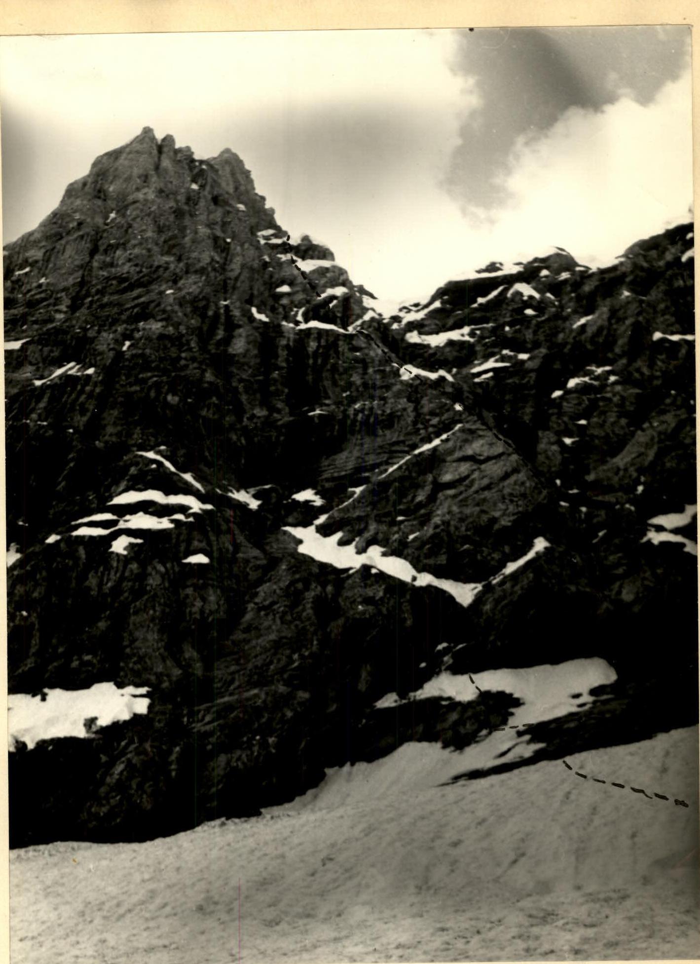
Fig. 2. Section numbers
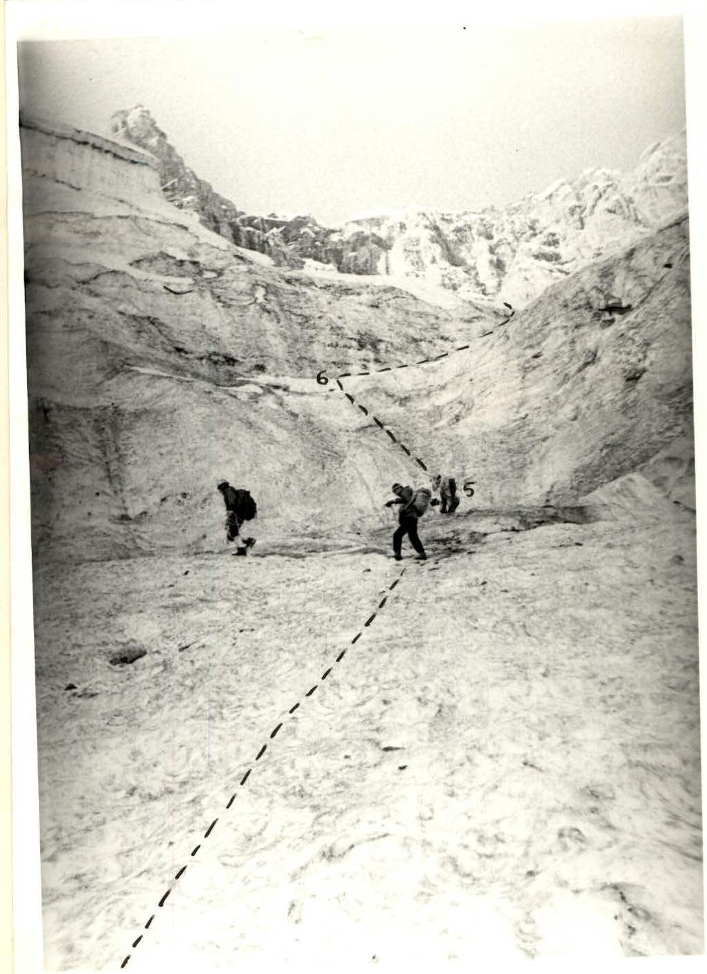
Photo 2. Route profile (rocky part)

Photo 3. Glacier traverse

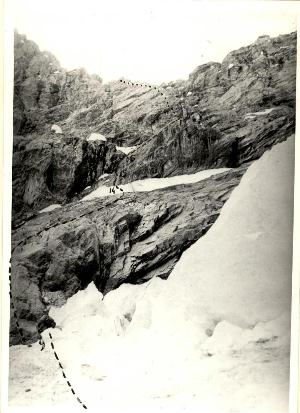
Photo 6. Start of the rocky part of the route